March 2022 Severe Weather Events - March 12th, 2022
←
→
Page content transcription
If your browser does not render page correctly, please read the page content below
March 2022 Severe Weather Events
                                       March 12th, 2022
        In the early hours of March 12, 2022, a line of storms approached the FL peninsula. A well-
forecasted event, conditions were highly favorable for severe storms to develop.

As the line of storms approached, what little convective inhibition remained quickly eroded as warm,
moist air was pumped northeastward. Mixed-Layer Convective Available Potential Energy (MLCAPE)
values quickly increased to over 1000 J/KG.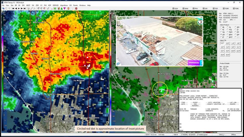
In contrast to many cool-season systems, the parent trough axis associated with the surface cold front
remained in trail, and did not lift northward until later into the day. Thus, shear values remained high
due to a very dynamic atmosphere above.
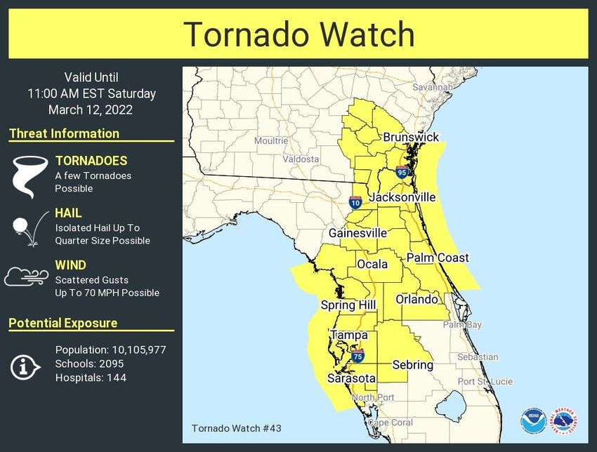
The atmosphere was both primed for supercells and tornadoes. Derived calculations for supercell
potential (SCP) and tornado potential (STP) indicated a significant risk for rotating storms and tornadoes.
The highly sheared environment also supported faster winds aloft being mixed to the surface as
thunderstorms moved by.

Just after 3:30AM on the 12th, a tornado watch was issued for a large portion of central and northern
Florida in the region where tornadoes were most likely to occur. Subsequent discussions and products
highlighted the continued risk for storms across the area through the day.
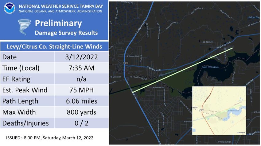
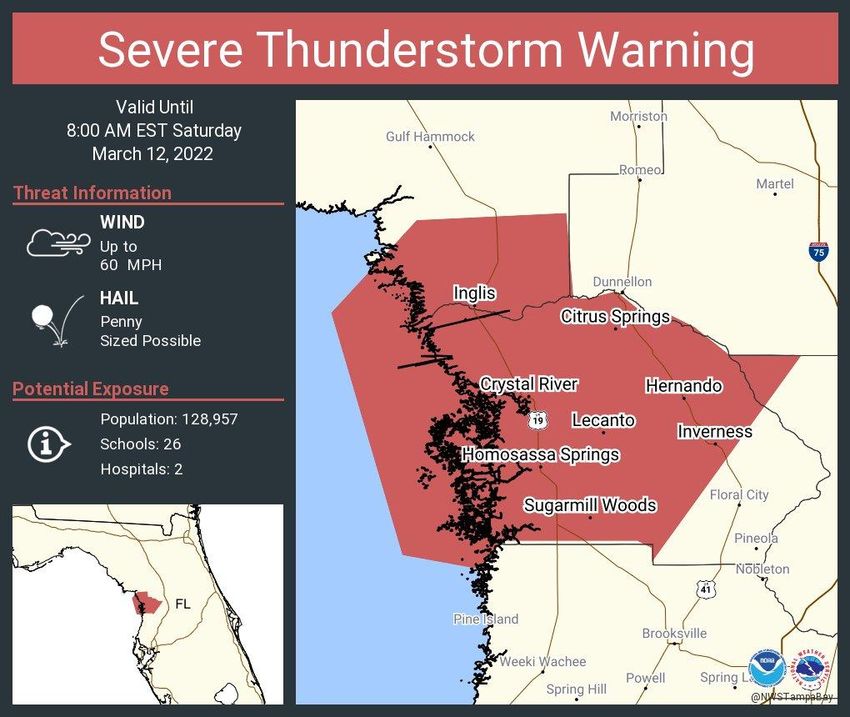
The first severe thunderstorm warning was issued shortly after 7AM for portions of the Nature Coast.

In association with these storms, straight-line wind damage occurred across Northern Citrus and
Southern Levy County, near Inglis, FL.
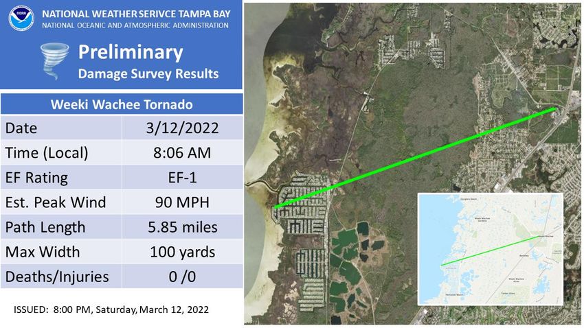
Just over a half an hour later, the first tornado warning of the day was issued

This storm produced an EF1 tornado as it passed through the Weeki Wachee area. Additional wind
damage occurred with this storm as it continued to trek inland.

As the line continued to propagate southward, additional severe weather occurred.
Public Information Statement
National Weather Service Tampa Bay Ruskin FL
505 PM EST Sat Mar 12 2022

...PEAK WIND GUSTS FOR MARCH 12 2022...

A line of strong to severe thunderstorms moved across West Central
and Southwest Florida today ahead of cold front. Strong gusty winds
accompanied these storms, but in many areas the strongest winds
occurred after the storms moved through behind the cold front.
Below is a list of some of the top wind gusts for today.
Max Wind
Station Name               County           ID       Provider     Speed(mph)

Clam Bayou Nature Park     Pinellas         XCBN     WXFLOW         65
Weeki Wachee               Hernando         XWKI      WXFLOW        63
Tampa Bay Cut J            Tampa Bay        XTAM      WXFLOW        59
Sarasota Bay Marker 17     Gulf of Mexico   XSRB      WXFLOW        54
1.9 NE Belleair            Pinellas         0579W    WXSTEM         53
Belleair                   Pinellas         EW6508    CWOP          52
Skyway Fishing Pier        Tampa Bay        XSKY      WXFLOW        52
Brooksville                Hernando         KBKV      ASOS          51
Clearwater Beach           Pinellas         FW1789   CWOP           50
2.9 W Crystal River        Citrus           0212W     WXSTEM        50
Sarasota-Bradenton Int'l   Manatee          KSRQ     ASOS           50
Cedar Key                  Levy             CKYF1     NOS-NWLON     49
St Pete-Clearwater Int'l   Pinellas         KPIE     ASOS           49
Spring Hill                Hernando         EW8085    CWOP          48
Seminole                   Pinellas         FW8592    CWOP          48
Venice                     Sarasota         KVNC      AWOS           47
St. Petersburg             Pinellas         SAPF1     NOS-NWLON     47
Desoto-Orange              Lee              XDSO     WXFLOW         47
Charlotte Harbor Yacht     Charlotte        XCHY      WXFLOW        47
New Pass Shoal Light       Gulf of Mexico   XLID      WXFLOW        47
Fort Myers - Page Field    Lee              KFMY     ASOS           46
St. Petersburg             Pinellas         KSPG      ASOS          46
St Pete Beach              Pinellas         EW8104    CWOP          46
Avon Park Af Range 1       Highlands        APRF1     RAWS          46
Grove City                 Charlotte        XGRV      WXFLOW        46
1 S Venice                 Sarasota         VENF1     NDBC          45
4.9 NW Masaryktown         Hernando         0209W     WXSTEM        45
Fort Myers - SW Int'l      Lee              KRSW     ASOS           44
Clearwater Beach Pier 60   Gulf of Mexico   CWBF1     NOS-NWLON     44
0.8 SE Cedar Key           Levy             1057W     WXSTEM        44
Winter Haven             Polk             KGIF     ASOS        43
Crystal Beach            Pinellas         EW2528   CWOP        43
22 SW Longboat Key       Gulf of Mexico   42013    NDBC        43
Old Port Tampa           Hillsborough     OPTF1    NOS-PORTS   43
Fort Myers               Lee              FMRF1    NOS-NWLON   42
1.9 W Bayshore Gardens   Manatee          0400W    WXSTEM      42
Dunedin Causeway         Pinellas         XDUN     WXFLOW      42
Griffin                  Polk             XGRF     WXFLOW      42
Punta Gorda              Charlotte        KPGD     ASOS        42
Clearwater               Pinellas         KCLW     AWOS        41
8 SE Saint Petersburg    Tampa Bay        MTBF1    NDBC        41
3.0 SE Cape Coral        Lee              0492W    WXSTEM      41
Polk City                Polk             AS291    CWOP        41
Tampa                    Hillsborough     KTPA     ASOS        40
Sebring Air Terminal     Highlands        KSEF     AWOS        40
1 W Fort Myers           Lee              FRTPC    AWS         40
Center Hill              Sumter           FW2402   CWOP        40
Chiefland                Levy             FW9298   CWOP        40
2 W Tarpon Springs       Gulf of Mexico   FHPF1    NDBC        40
1.2 SW Largo             Pinellas         0503W    WXSTEM      40
2.9 S Archbold           Highlands        1158W    WXSTEM      40
Belleair                 Pinellas         XBLA     WXFLOW      40
March 16th, 2022
Unlike the 12th, conditions on the 16th were much more conditional. The 12Z sounding launched by NWS
Tampa Bay captures this well:

A capping inversion was in place at 650mb, with dry air above. The main question was whether the cap
would erode in time, and if dry air would potentially limit convective growth. Temperatures at 500mb
were extremely cold (-13°C), meaning large hail was a very real possibility. However, it was conditional.
Storms would have to grow tall enough to be able to take advantage of this.

Low-level conditions were not particularly impressive at 12Z, but continued warm air advection at the
surface provided increased veering through the day and enhancements to low-level hodographs, such
that a weak and brief tornado was not out of the question in rotating supercells.
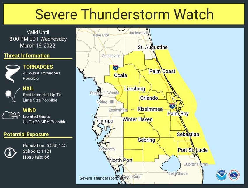
Eastern sections of West Central Florida were identified as the region of greatest risk. By afternoon,
increasingly favorable conditions had indeed materialized, and a Severe Thunderstorm Watch was
issued.

This was issued just as storms were beginning to develop. It wouldn’t take very long before cells
intensified, and hail became an issue, particularly in East Central Florida. However, one cell was able to
intensify over West Central Florida in Polk County.
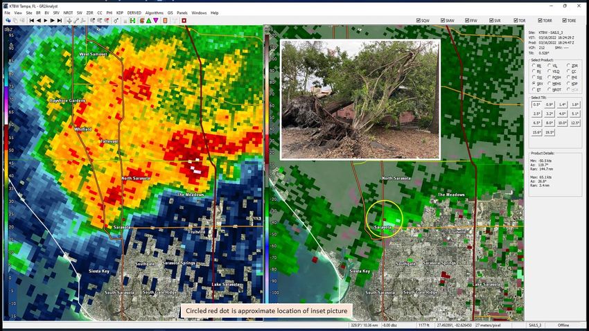
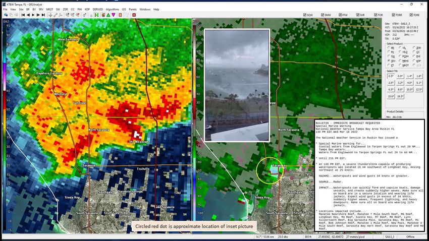
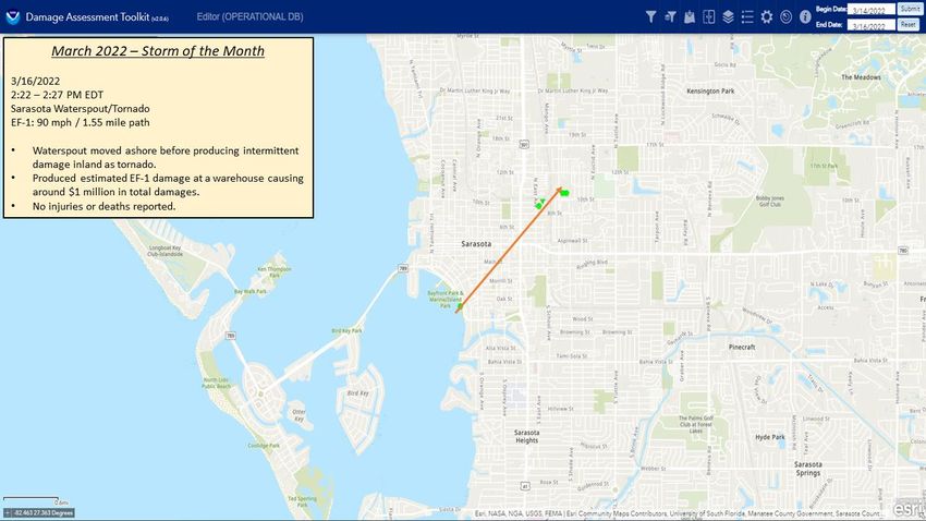
Large, severe hail is likely to have occurred in the area to the east of Lake Wales. Thankfully, this fell to
the east of the city, with the largest hail reported was only dime size. In the even more conditional
environment along the west coast, there was also a brief tornado touchdown in Sarasota, FL.
March 24th, 2022
March 24th was largely a null event. Several competing factors were at play that ultimately tipped in the
     direction of unfavorable. The factor that most likely contributed most greatly was moisture.
This analysis of Precipitable Water (PW) from 15Z on the 24th would suggest that more than sufficient moisture was present. However, too much of a good thing can be a bad thing. The PW value recorded in the 12Z sounding was a record, meaning more moisture was present in the atmosphere on this day than had ever been recorded. This created a scenario where two things ended up occurring that limited storms ability to grow severe: 1.) cloud cover was prevalent over much of the peninsula; this limited CAPE and weakened lapse rates, which created a scenario where depth was limited in most storms 2.) convection infrequently remained discrete; the multicellular modes were much more prevalent, which prevented convection from taking full advantage of an otherwise favorable environment
You can also read