Cape Reinga to Ahipara - Walking Difculties Medium , Hard - Walking Access Commission
←
→
Page content transcription
If your browser does not render page correctly, please read the page content below
Cape Reinga to Ahipara Walking Dif culties Medium , Hard Length 100.6 km Journey Time 4 days Region Northland Sub-Region Far North Part of Collections Te Araroa - New Zealand's Trail , Te Araroa - North Island
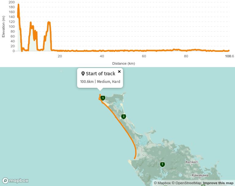
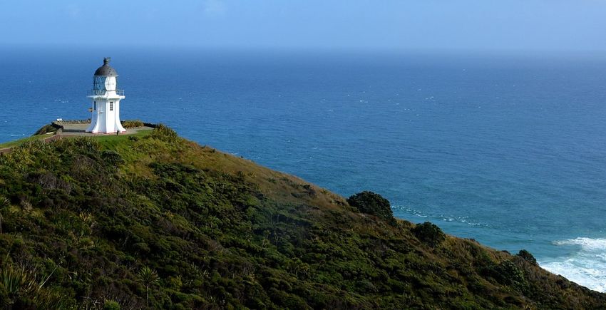
North to South

As Walkers pass through Kaitaia on their way North to start at Cape Reinga, they are
advised to call in to the i-SITE (Te Ahu Centre, Corner Matthews Avenue and South Road ),
where they can ll in Te Araroa Intentions Book. This is for their own safety on '90 Mile
Beach'. While there they can also nd out about accommodation in Kaitaia and transit to
Cape Reinga. Te Ahu is a large cultural centre with a library, computers, cafes and a
cinema.

There are limited locations where camping is allowed between Cape Reinga and Ahipara -
we suggest the following plan:

   Day One - Cape Reinga to Twilight Beach campsite (12km)
   Day Two - Twilight Beach campsite to Maunganui Bluff campsite (28km)
   Day Three - Maunganui Bluff campsite to Hukatere Lodge/Utea Park (30km)
   Day Four - Hukatere/Utea Park to Waipapakauri Holiday Park (17km) or Ahipara (a
   further 14km)

Please do not free camp in the Aupōuri Forest that runs alongside 90 Mile Beach, stick to
the above locations.

Generally, there is water available in these locations - in extremely dry times the tank at
Twilight Beach may run out so unless you are aware of recent rain, it is advisable to carry
enough water from Cape Reinga to reach Maunganui Bluff.

From Cape Reinga, the track heads towards the West Coast, leading you down past steep
cliffs and over rocks to the long, sweeping Te Werahi Beach. Note: You are best to set off at
a lowish tide to make the rock scrambling and stream crossing safer & easier. Carry enough
water for your rst day.

Beyond Te Werahi Beach, you will experience gorgeous peach-coloured dunes, unusual
dune grasses, and views of Cape Maria Van Diemen and Motuopao Island. You follow orange
marker posts over Hērangi Hill, pass the turnoff to Cape Maria Van Diemen and along
clifftops of ax and mānuka scrublands, before dropping down to Twilight Beach. Exit the
south end of Twilight Beach on the 4WD track next to the orange marker. Just above the
south end of Twilight Beach (12km from Cape Reinga) is a small campsite with toilet, water
supply and a covered area - recommend stopping here, then planning to reach Maunganui
Bluff (28km away) the following day. Please camp within the grassed area ONLY, not in the
pine trees.
The track climbs up and over Scott Point then drops down to Ninety Mile Beach, crossing a
swamp via a boardwalk and down a steep set of steps. While passing over Scott Point, you
will need to watch carefully for a quad motorbike track which veers right off the main 4WD
track. The marker may be very dif cult to see.)

    Note: If you come to a farm gate and a paddock, you will need to double back about 10
    minutes, as you have gone the wrong way.

Follow Ninety Mile Beach south for approximately an hour until you come to Te Paki
Stream mouth. This is a popular vehicle entrance/exit to the beach so be prepared for cars
and tourist buses around there and further south. From the stream mouth, it is 1 hour
upstream to the road should you wish to exit the beach here.

From Te Paki Stream, you walk down the beach to Ahipara. Try to time your walking to
avoid high tide as in parts the water can come all the way up to the dunes and make for
either wet feet or a need to walk in the hilly dunes.

Landmarks you’ll pass are The Bluff (40km from Cape Reinga), Hukatere (68km) and
Waipapakauri (85km).

Leave the beach at the Kaka Street boat ramp and nd your way into Ahipara village, a
popular holiday and sur ng hotspot at the southern end of Ninety Mile Beach and 14km
west of Kaitāia.

 Conditions:

 Track standard: tramping track

 Potential Hazards
      Vehicles on road or track on Ninety Mile Beach and Kaka St boat ramp
       Tides, waves and rivers - safer at low tide
       Small stream crossings
       Track exposed to sun, wind or cold
       Few water sources
       Steep drop-offs - take care on wet rocks - can be slippery
       Wild feral dogs
How to get here Northern Start: Cape Reinga Southern End: Boat ramp, Kākā Street, Ahipara Te Araroa's northern terminus in the North Island is at Cape Reinga, which is accessible by road. Kaitaia is the most northern gateway town to Cape Reinga, servicing a population of approximately 5200. An alternative is Kerikeri, which has the advantage of being on the trail should you want to leave gear. Tide times are important for coastal routes Track Elevation and Map
More information
Northland trail notes, including information about accommodation, transport and
resupplying

   Map 1
   Map 2
   Map 3
   Map 4
   Map 5
   Map 6
   Map 7

Cape Reinga

   Far North i-SITE Visitor Information Centre   - Te Ahu, Corner Matthews Avenue and
   South Road, Kaitaia - P: 09 408 9450 - E: kaitaia@visitnorthland.co.nz
   Department of Conservation Information Of ce       - 25 Matthews Ave, Kaitaia - P: 09
   408 6014 - E; kaitaia@doc.govt.nz

Kaitaia

   Far North i-SITE Visitor Information Centre   - Te Ahu, Corner Matthews Avenue and
   South Road, Kaitaia - P: 09 408 9450 - E: kaitaia@visitnorthland.co.nz
   Department of Conservation Information Of ce       - 25 Matthews Ave, Kaitaia - P: 09
   408 6014 - E: kaitaia@doc.govt.nz
Page last updated: Nov 10, 2021, 11:40 AM
You can also read