GRADE 10 NOVEMBER 2020 GEOGRAPHY P2 ADDENDUM (EXEMPLAR) - NATIONAL SENIOR CERTIFICATE
←
→
Page content transcription
If your browser does not render page correctly, please read the page content below
NATIONAL
SENIOR CERTIFICATE

      GRADE 10

NOVEMBER 2020

 GEOGRAPHY P2
   ADDENDUM
  (EXEMPLAR)

  This addendum consists of 9 pages.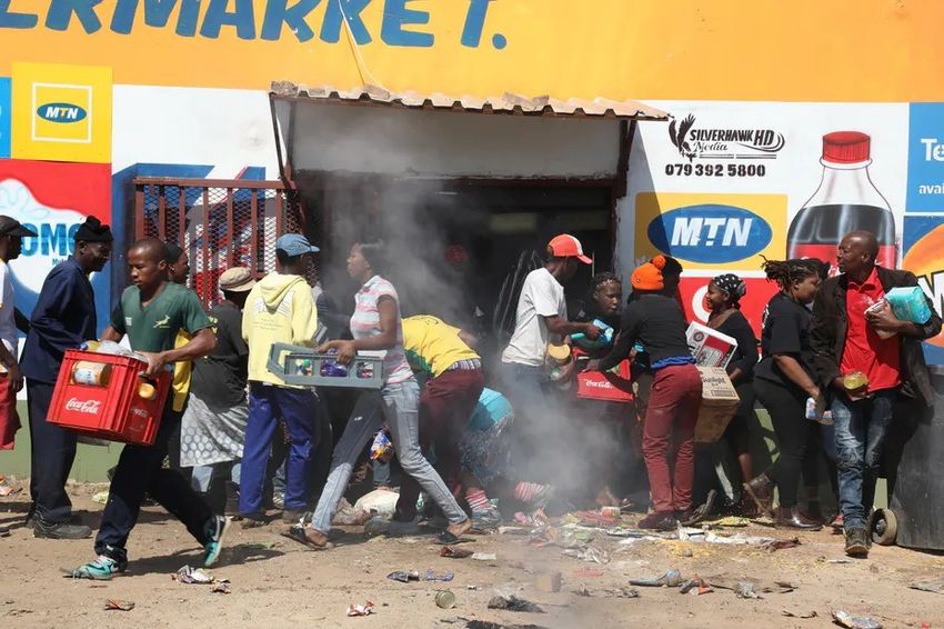
2                            GEOGRAPHY P2 (ADDENDUM)                (EC/NOVEMBER 2020)

 FIGURE 1.2:         POPULATION PYRAMIDS FOR DEVELOPED AND DEVELOPING
                     COUNTRIES

                     PYRAMID A                         PYRAMID B

                                                              [Source: Google Images]

 FIGURE 1.3 A: WORLD POPULATION DISTRIBUTION

                                                              [Source: www.bbc.co.uk]

Copyright reserved                                                    Please turn over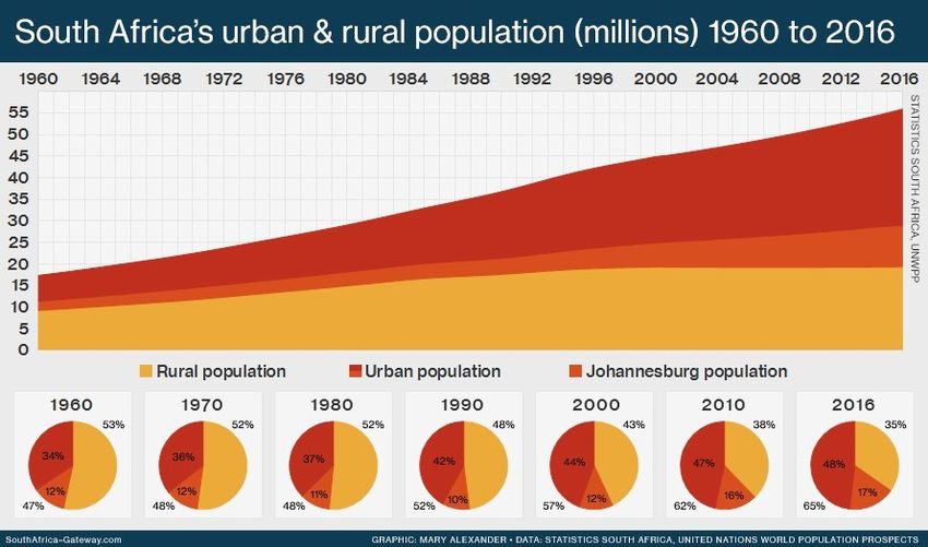
3                            GEOGRAPHY P2 (ADDENDUM)                          (EC/NOVEMBER 2020)

FIGURE 1.3B: WORLD’S HIGHEST POPULATED COUNTRIES

     COUNTRY         POPULATION          DENSITY          LAND AREA            FERTILITY
                                          (P/km2)            (km2)               RATE
    CHINA            1 439 323 776          153            9 388 211              1,7
    INDIA            1 380 004 385          464            2 973 190              2,2
    USA                331 002 651           36            9 147 420              1,8
    INDONESIA          273 523 615          151            1 811 570              2,3
                                                                     [Source: www.worldometers]

 FIGURE 1.4: XENOPHOBIA IN SOUTH AFRICA (2018)

 Foreign nationals have, yet again, been attacked, displaced and had their shops looted in
 South Africa. This is an unfortunate – but entirely unsurprising way to mark the anniversary
 of the 2008 xenophobic attacks during which tens of thousands were displaced and more
 than 60 people killed.

 Even before 2008, a handful of scholars and activists were urging the government to do
 more to protect those targeted for violence because of their geographic origins. Only after
 the 2008 melee did the government join civil society and international organisations in
 committing to ensure that such bloodletting would never happen again. But it has.

                                                                  [Source: www.wits.ac.za/news]

Copyright reserved                                                              Please turn over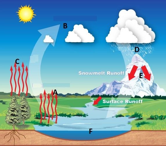
4                    GEOGRAPHY P2 (ADDENDUM)             (EC/NOVEMBER 2020)

 FIGURE 1.5: SOUTH AFRICA’S URBAN AND RURAL POPULATION

                                                   [Source: StatsSA (2016)]

 FIGURE 2.1: THE WATER CYCLE

                                                [Source: www.weather.gov]

Copyright reserved                                          Please turn over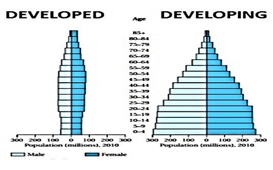
5 GEOGRAPHY P2 (ADDENDUM) (EC/NOVEMBER 2020)
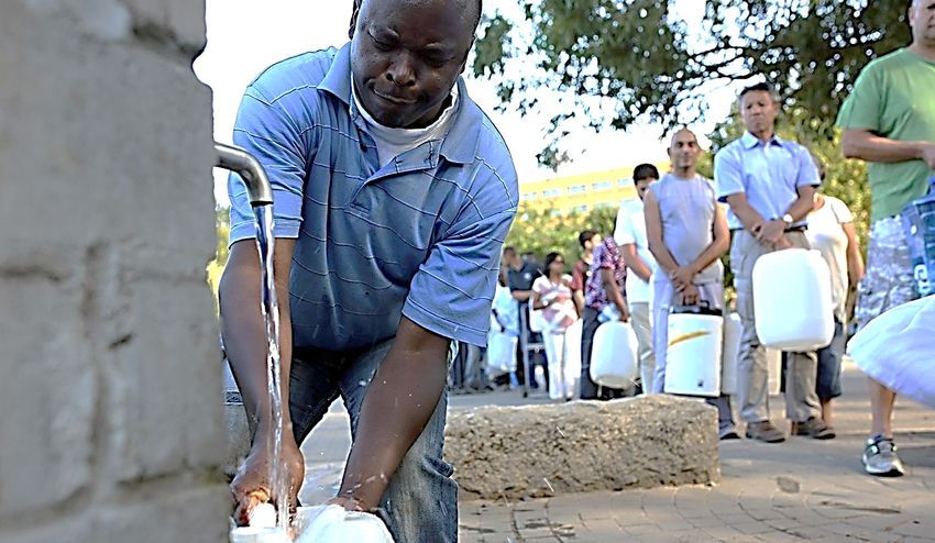
FIGURE 2.3: WAITING FOR DAY ZERO, CAPE TOWN
[source: Google Images]
Daily Maverick: 29 January 2018
Marelise Van Der Merwe
Cape Water Gate Explainer: What do we know about Cape Town’s disaster management
plan?
On Sunday morning, officials gathered at the disaster Risk Management Centre in
Goodwood, Cape Town, to brief media on preparations for day Zero. This followed hot on
the heels of the launch of the #Defeat Day Zero campaign in Athlone the previous week.
Information is trickling in bit by bit.
The date, as we know, can shift, but City officials have confirmed that it will kick in when
dam levels hit 13.5%. The member of Safety and Security said it would take approximately
two weeks to shut down water systems and similarly take a couple of weeks to activate
the water points and other disaster management systems, so those two processes would
overlap, although preparations were already underway.
It should be noted that Day Zero is not the day Cape Town ‘runs out’ of water. It is the day
officials move from Phase One preservation restrictions to Phase Two, what the City has
termed disaster restrictions.
Copyright reserved Please turn over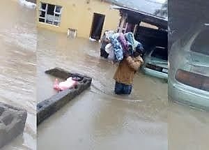
6                           GEOGRAPHY P2 (ADDENDUM)                        (EC/NOVEMBER 2020)

 FIGURE 2.4: FLOOD IN PORT ST JOHNS

 Residents evacuated amid heavy rainfall

 Port St Johns, on the Wild Coast in the Eastern Cape, has been battered by heavy rains
 and localised flooding, leading to large scale evacuations. The region of Green Farm,
 situated along the Mzimvubu River, which burst its banks on Monday, has been
 particularly hard-hit by flash flooding.

 According to SABC News, large portions of the low-lying rural settlements have been left
 inaccessible.
                                                           [Source: www.thesouthafrican.com]

Copyright reserved                                                           Please turn over
7 GEOGRAPHY P2 (ADDENDUM) (EC/NOVEMBER 2020)
FIGURE 2.5: CHANGE IN THE AMOUNT OF CAPE HORSE MACKEREL IN SOUTH
AFRICAN WATERS
[Source: www.statssa.gov.za]
List of words of some of the Afrikaans and English words and their translation that
appear on the topographical map.
ENGLISH AFRIKAANS
Landing strip Vliegveld
Furrow Voor
Caravan park Karavaanpark
Canal Kanaal
Sewerage works Rioolwerke
Golf course Gholfbaan
Excavation Uitgrawing
Nature reserve Natuurreservaat
Rifle range Skietbaan
Aerodrome Vliegveld
Ravine Kloof
Copyright reserved Please turn over8 GEOGRAPHY P2 (ADDENDUM) (EC/NOVEMBER 2020)
GENERAL INFORMATION ON SOMERSET WEST
Somerset West is a town in the Western Cape, South Africa. Organisationally and
administratively it is included in the City of Cape Town metropolitan municipality as a suburb
in the Helderberg area (formerly called Hottentots Holland), about 50 kilometres east of Cape
Town central city area, and bordering on Strand. The town is overlooked by the Helderberg
Mountain (meaning ‘clear mountain’).
Coordinates: 34° 07′ 56″ S, 18° 50′ 36″ E
[Source: https://www.weather-forecast.com]
Copyright reserved Please turn over9 GEOGRAPHY P2 (ADDENDUM) (EC/NOVEMBER 2020) FIGURE 3.3.4 Copyright reserved Please turn over
You can also read


