SOCIAL HOUSING DEVELOPMENT RATHELLLEN, FINISKLIN, CO. SLIGO - Mobility Management Plan
←
→
Page content transcription
If your browser does not render page correctly, please read the page content below

SOCIAL HOUSING DEVELOPMENT

RATHELLLEN, FINISKLIN, CO. SLIGO
Mobility Management Plan

                                     SHB3-FIN-CS-RPS-RP-004
                                   Mobility Management Plan at
                                                 Finisklin, Sligo
                                                          S4.P02
                                              7th February 2022

                                              rpsgroup.com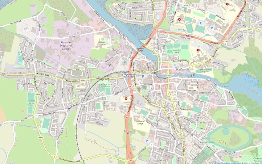
MOBILITY MANAGEMENT PLAN

Document status

Version      Purpose of document                     Authored by             Reviewed by              Approved by       Review date

S3.P01       Review and Comment                      PD                      PMGB                     DK                24/09/2021

S4.P02       Issue for Part 10 Planning              PD                      PMGB                     DK                07/02/2022

Approval for issue

DK                                                                                                    7 February 2022

© Copyright RPS Group Limited. All rights reserved.
The report has been prepared for the exclusive use of our client and unless otherwise agreed in writing by RPS Group
Limited no other party may use, make use of or rely on the contents of this report.
The report has been compiled using the resources agreed with the client and in accordance with the scope of work
agreed with the client. No liability is accepted by RPS Group Limited for any use of this report, other than the purpose for
which it was prepared.
RPS Group Limited accepts no responsibility for any documents or information supplied to RPS Group Limited by others
and no legal liability arising from the use by others of opinions or data contained in this report. It is expressly stated that
no independent verification of any documents or information supplied by others has been made.
RPS Group Limited has used reasonable skill, care and diligence in compiling this report and no warranty is provided as
to the report’s accuracy.
No part of this report may be copied or reproduced, by any means, without the written permission of RPS Group Limited.

 Prepared by:                                                           Prepared for:

 RPS                                                                    Sligo County Council

SHB3-FIN-CS-RPS-RP-0004 | Mobility Management Plan at Finisklin, Sligo | S4.P02 | 7th February 2022
rpsgroup.com                                                                                                                  Page i
MOBILITY MANAGEMENT PLAN

Contents
1        INTRODUCTION ......................................................................................................................................3
         1.1 Site Location...................................................................................................................................3
         1.2 Proposed Development ..................................................................................................................5
         1.3 Policy Background .........................................................................................................................6
2        RECEIVING ENVIRONMENT AND SITE ACCESSIBILITY....................................................................8
         2.1 Existing Road Network ...................................................................................................................8
         2.2 Public Transport Connectivity ........................................................................................................8
             2.2.1 Bus ....................................................................................................................................8
             2.2.2 Rail ....................................................................................................................................9
         2.3 Cycling Connectivity .....................................................................................................................10
         2.4 Walking Connectivity ....................................................................................................................12
3        TRAVEL PATTERNS, OBJECTIVES AND TARGETS .........................................................................14
         3.1 Local Census Data Review of Existing Travel Patterns ...............................................................14
         3.2 Local Census Data Review of Vehicles per Household ...............................................................15
         3.3 Travel Objectives and Targets .....................................................................................................16
         3.4 Modal Split Target ........................................................................................................................16
4        PARKING STRATEGY ..........................................................................................................................18
         4.1 Car Parking ..................................................................................................................................18
         4.2 Bicycle Parking .............................................................................................................................19
         4.3 Motorcycle & Mobility Scooter Parking ........................................................................................19
         4.4 Electric Vehicles ...........................................................................................................................19
5        PRELIMINARY ACTION PLAN .............................................................................................................20
         5.1 Monitoring and Management .......................................................................................................22

Figures
Figure 1-1: Site Location (Source: openstreetmap.org) .....................................................................................4
Figure 1-2: Site Boundary ...................................................................................................................................4
Figure 1-3: Site Layout .......................................................................................................................................5
Figure 2-2: Bus Stop 554751 on Sea Road, Route S2 ......................................................................................9
Figure 2-3: Bus Stop on Route S2 – Timetable ..................................................................................................9
Figure 2-4: Irish Rail, Sligo to Dublin Connelly Route Map ..............................................................................10
Figure 2-4: Existing Cycle Facilities Map (Source: openstreetmap.org) ..........................................................11
Figure 2-5: Sea Road, view to the south of existing footpath and advisory cycle lanes ..................................11
Figure 2-6: Far Finisklin Road, view to the west of existing cycle facilities ......................................................12
Figure 2-7: Finisklin Road, view to the east towards Sligo town of existing raised, two-way cycle
              facilities .........................................................................................................................................12
Figure 2-8: Existing Footpaths on First Sea Road (Left) and Sea Road (Right) ..............................................13
Figure 3-1: Census 2016 Small Area Population Statistic Areas (Source: https://cso.maps.arcgis.com) .......15
Figure 3-2: Census 2016 Small Area Population Statistic Data (Modal Split - 8 SAPS areas) ........................15
Figure 3-3: Census 2016 Small Area Population Statistic Data (Vehicles per Household - 8 SAPS
              areas) ...........................................................................................................................................15

Appendices
                  Existing Public Transport Maps

SHB3-FIN-CS-RPS-RP-0004 | Mobility Management Plan at Finisklin, Sligo | S4.P02 | 7th February 2022
rpsgroup.com                                                                                                                                               Page ii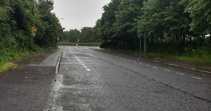
MOBILITY MANAGEMENT PLAN

1            INTRODUCTION
RPS are the appointed Civil and Structural Engineering advisors for the proposed residential development at
Rathellen, Finisklin, Co. Sligo. This project will deliver 39 houses and 24 apartments to Sligo County Council
Planning Authority. RPS have been commissioned to prepare a Mobility Management Plan (or Travel Plan)
as part of a planning application for the proposed social housing development.
The objective of this Mobility Management Plan (MMP) is to provide a co-ordinated approach to managing
travel demand for the proposed social housing development as well as identifying and actively promoting
sustainable travel for future residents. This MMP has gathered information on existing travel patterns in the
surrounding areas in order to set achievable and sustainable travel targets for the development. These
targets take account of existing and future transportation infrastructure around the proposed site. The
recommended measures (in the form of an action plan) will promote the attractiveness of walking, cycling,
public transport, and other travel alternatives while reducing dependence on the private car, especially single
occupancy journeys. MMPs have the overall aim of reducing CO2 emissions, traffic congestion and noise
pollution while increasing air quality, physical activity and overall wellbeing.
A fundamental element of a MMP is the appointment of a mobility manager (or champion) who will be
responsible for the revision and implementation of this ‘live’ plan after the occupation of the development.
The NTA Publication ‘Workplace Travel Plans: A Guide for Implementers’ highlights the importance of a
dedicated ‘mobility manager’ who can give their time on a regular basis to promote sustainable travel. The
appointed PPP consortium will be responsible for the appointment of a mobility manager.
RPS undertook a site visit of the external road network surrounding the Finisklin site on the 24th June 2021 to
assess the existing site accessibility in terms of public transport, cycling and walking.

1.1          Site Location
The proposed site is located at Rathellen, Finisklin, Sligo. The site is bounded to north by Far Finisklin Road,
to the west by Sea Road and to the south by the IDA Sligo Business Park. Access to the site is currently
from Far Finisklin Road to the north. The site location is shown in Figure 1-1 with the site boundary shown in
Figure 1-2.
The site is located on the outskirts of the predominantly industrial area of Finisklin, with large IDA parks in
the immediate vicinity. In the surrounding areas the site is served by local amenities including Sligo town
centre, shops, schools, churches, sports grounds, Mitchel Curley Park and the main Sligo train and bus
stations. In the wider area surrounding the site are IT Sligo, Doorly Park, and Strandhill town/beach for which
there are dedicated cycle facilities directly from the site.

SHB3-FIN-CS-RPS-RP-0004 | Mobility Management Plan at Finisklin, Sligo | S4.P02 | 7th February 2022
rpsgroup.com                                                                                              Page 3

MOBILITY MANAGEMENT PLAN

                                                                                    Finisklin Site
                                                                                        Site

                                  Figure 1-1: Site Location (Source: openstreetmap.org)

                                                                                                      Site boundary

                                                                                                        Proposed
                                                                                                        vehicular
                                                                                                         access

                                              Sea
                                              Road

                                                     Figure 1-2: Site Boundary

SHB3-FIN-CS-RPS-RP-0004 | Mobility Management Plan at Finisklin, Sligo | S4.P02 | 7th February 2022
rpsgroup.com                                                                                                    Page 4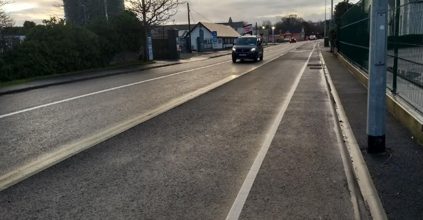
MOBILITY MANAGEMENT PLAN
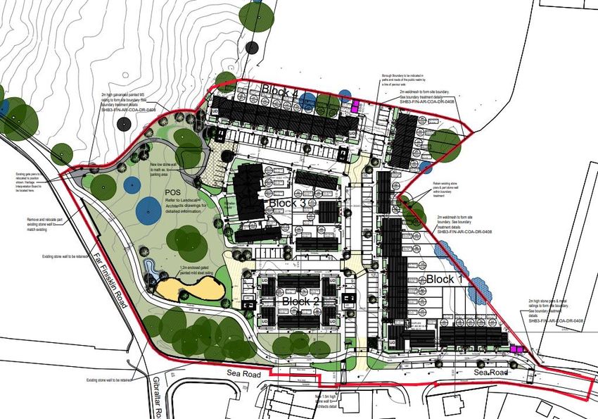
1.2 Proposed Development
The Social Housing PPP Programme consists of the design, construction, financing and maintenance of
approximately 1,500 homes in 3 project bundles on sites around Ireland to be delivered by Public Private
Partnership (PPP). The maintenance, upkeep and tenancy management services for each development will
be for a 25-year period following construction, and the homes will then be returned to Local Authority
ownership. The proposed Finisklin development is part of Bundle 3, consisting of six separate sites to be
delivered across four Local Authorities.
The Finisklin site is located on the disused Rathellen house site in Sligo. The proposed development
comprises 63No. units including:
• 18No. Duplexes
• 39No. New Houses
• 6No. Converted Houses in the existing Rathellen House
A number of units will be designed to universal design standards to accommodate visually, mobility or
sensory impaired residents. Vehicular, pedestrian and cyclist access to the site will be facilitated at two
points, one on Far Finisklin Road and one on Sea Road.
There are 100no. parking spaces proposed within the site boundary, of which 6No. are mobility impaired
parking spaces. This equating to a parking ratio of 1.58 per unit.
As part of future phases of the development, it is proposed to realign the high demand horizontal alignment
on Far Finisklin Road and provide dedicated cyclist and pedestrian facilities to tie into to the existing facilities
in the surrounding area. The proposed development layout is shown in Figure 1-3.
Proposed access
Proposed bus stops
Proposed
pedestrian crossing
Figure 1-3: Site Layout
SHB3-FIN-CS-RPS-RP-0004 | Mobility Management Plan at Finisklin, Sligo | S4.P02 | 7th February 2022
rpsgroup.com Page 5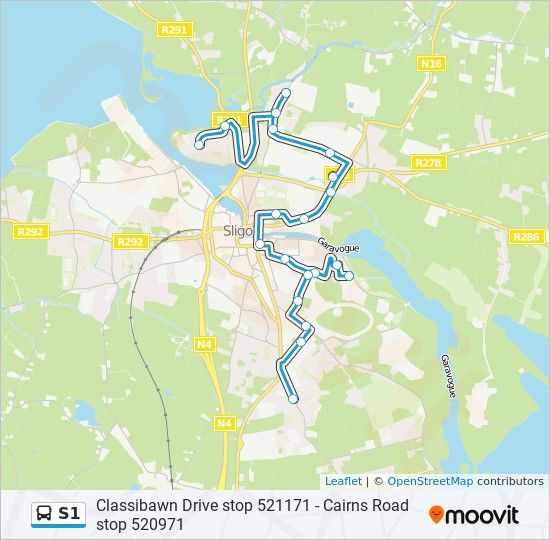
MOBILITY MANAGEMENT PLAN

1.3          Policy Background
Promoting and facilitating alternative modes of travel to single, private car occupancy is a key national policy.
This section reviews some of the national and local policy, plans and programmes relevant to this
development.
Smarter Travel ‘A Sustainable Transport Future. A New Transport Policy for Ireland 2009 – 2020 - The
Department of Transport, Tourism and Sport (DTTAS) launched this policy document as a vision for
sustainability in transport and it sets out five key goals: (i) to reduce overall travel demand, (ii) to maximise
the efficiency of the transport network, (iii) to reduce reliance on fossil fuels, (iv) to reduce transport
emissions and (v) to improve accessibility to transport.
A key target for 2020 was that 500,000 more people will take alternative means to work to the extent that the
total share of car commuting will drop from 65% to 45%. Alternatives such as walking, cycling and public
transport will be supported and provided to the extent that these will rise to 55% of total commuter journeys
to work. Achieving sustainable transport will require a suite of actions that will have complementary impacts
in terms of travel demand and emissions. Although the policy document contains 49 actions, they can be
grouped into essentially four overarching goals:
      –     Actions to reduce distance travelled by private car and encourage smarter travel, including focusing
            population and employment growth predominantly in larger urban areas and the use of pricing
            mechanisms or fiscal measures to encourage behavioural change.
      –     Actions aimed at ensuring that alternatives to the private car are more widely available, mainly
            through a radically improved public transport service and through investment in cycling and
            walking.
      –     Actions aimed at improving the fuel efficiency of motorised transport through improved fleet
            structure, energy efficient driving, and alternative technologies.
      –     Actions aimed at strengthening institutional arrangements to deliver the targets.
Project Ireland 2040 National Planning Framework 2018 - Sustainable mobility is a stated shared goal in
the National Planning Framework, including a move away from polluting and carbon intensive propulsion
systems. The framework has ten National Strategic Outcomes with Number 4 being ‘Sustainable Mobility
and a well-functioning integrated public transport system to enable mobility choices for citizens’. The
framework highlights that ‘enhancing the city-region like functions performed by Sligo in line with its statutory
development plan, activating the potential for further rejuvenation and renewal of its core and further
enhancing its connectivity in a national and regional context to ensure wider accessibility of relevant services
and amenities’ is a key future planning and development and place-making policy for the Northern and
Western Region.
Project Ireland 2040 National Development Plan 2018 to 2027 - This plan expands upon National
Strategic Outcome Number 4 to develop sustainable mobility. The plan identified Sligo as a regional centre
in the north-west. Several sustainable transport projects are identified for delivery by 2027 in Sligo to provide
additional sustainable travel options. These include fast, high-frequency electrified services on the
Maynooth/Sligo line and the completion of the Western Distributor Road.
Sligo County Development Plan 2017 to 2023 – This plan outlines the requirement of Mobility
Management Plans in Section 13.8.1 to promote sustainable land-use and transportation practices. It is the
policy of Sligo County Council in SP-TRA-3 to “encourage the shift from car use to more environmentally-
friendly modes of transport and ensure the provision of quality interchange facilities between road, rail, bus
and bicycle in relevant settlements.” The plan sets out its objective for sustainable transport in SO-TRA-1 to
“develop a strategy to promote and facilitate greater use of sustainable modes of travel such as walking and
cycling, in line with the Department of Transport’s Smarter Travel, Cycle and Walking Strategies.”
Sustainable Urban Housing: Design Standards for New Apartments December 2020 – This design
standard states that planning authorities must consider a reduced overall car parking standard and apply an
appropriate maximum car parking standard for intermediate urban locations. These intermediate urban
locations may include locations served by public transport or close to town centres or employment areas and
should be applied particularly for housing schemes with more than 45 dwellings per hectare net (18 per
acre).

SHB3-FIN-CS-RPS-RP-0004 | Mobility Management Plan at Finisklin, Sligo | S4.P02 | 7th February 2022
rpsgroup.com                                                                                               Page 6
MOBILITY MANAGEMENT PLAN

Making Residential Travel Plans Work, Department of Transport UK 2007 – This UK guidance document
provides a framework for residential specific mobility management plans. The content of this report has been
informed by the guidance document.

It is considered the above policy documents reinforce the need for an active modal shift away from private
car use to more sustainable forms of transport such as walking, cycling, public transport and innovative
vehicle use (carpooling or car sharing clubs).

SHB3-FIN-CS-RPS-RP-0004 | Mobility Management Plan at Finisklin, Sligo | S4.P02 | 7th February 2022
rpsgroup.com                                                                                           Page 7

MOBILITY MANAGEMENT PLAN

2            RECEIVING ENVIRONMENT AND SITE ACCESSIBILITY
2.1          Existing Road Network
The site is bounded to north by Far Finisklin Road and to the west by Sea Road. Far Finisklin Road is a local
road which extends from its junction with Gibraltar Road and Sea Road, to the east side of Finisklin Road. A
vehicular, pedestrian and cyclist access from the development will be provided on Far Finisklin Road. The
road in the vicinity of the site is a narrow rural road with no footpaths, however the carriageway is delineated
to indicate that cyclists and vehicles are to share the carriageway. The proposed development in its future
phases will realign Far Finisklin Road and provide dedicated cyclist and pedestrian facilities to tie into to the
existing facilities and provide continuity for pedestrians and cyclists. These existing facilities on Far Finisklin
Road provide pedestrian and cyclist connectivity to the adjacent IDA parks, Finisklin area and Sligo Town
centre. The posted speed limit in the area is 50kph.
Sea Road is a local road to the east of the site connecting Finisklin Road and the industrial parks, to Far
Finisklin Road and Gibraltar Road. It is approximately 300m in length and has a posted speed limit of 50kph.
Sea Road is a wide semi urban road with a footpath on its western verge. At the southern extents of the site,
Sea Road changes into a wide urban road with footpaths and advisory cycle lanes on both sides of the
carriageway.

2.2          Public Transport Connectivity
The site is currently served by some public transport facilities and non-motorised road user infrastructure.
These facilities will support the promotion of sustainable travel to future residents. The various transport
facilities in the vicinity of the site are discussed in the following sections.

2.2.1        Bus
The site is located directly adjacent to an existing Bus Eireann stop on Sea Road. Currently these are basic
bus stops, however two new inline bus stops, one with a bus shelter will be provided as part of the
development. This bus stop serves the Sligo Inner route S2 extending from Strandhill, through Sligo town
centre to Rosses Point as shown in Figure 2-1. The posted S2 timetable at the Sea Road bus stop is shown
in Figure 2-2.
The Sligo Inner route S2 serves a number of significant locations in Sligo town including Scoil Ursula
Secondary school, Mac Diarmada Train and Bus Station (Magheraboy Knappagh Road), Sligo General
Hospital and IT Sligo with an hourly frequency between 08:16 to 21:06. The full timetable and route
information are shown in Appendix A. The site is also located approximately 2.2km from the Sligo Bus
Station which equates to a 27-minute walk or a 7-minute cycle.

      Proposed bus shelter                                                     Site location

SHB3-FIN-CS-RPS-RP-0004 | Mobility Management Plan at Finisklin, Sligo | S4.P02 | 7th February 2022
rpsgroup.com                                                                                                 Page 8
MOBILITY MANAGEMENT PLAN

                                  Figure 2-1: Bus Stop 554751 on Sea Road, Route S2

                                       Figure 2-2: Bus Stop on Route S2 – Timetable
Sligo town is also served by a number of local link bus services coming from the surrounding rural areas of
north County Sligo, south Donegal, west County Sligo and south County Sligo. Transport for Ireland (TFI)
Local Link use bus services to connect rural areas of Ireland. TFI Local Link bus services are described as
‘affordable and available for anyone wishing to travel to or from their local town or village’. An overview map
and timetables for local link services are included in Appendix A.

2.2.2        Rail
The site is located approximately 2.2km from the MacDiarmada Train Station which equates to a 27-minute
walk or a 7-minute cycle.
This station serves the Sligo to Dublin Connelly Route with 7 departures Monday-Friday. It provides rail
connection to neighbouring commuter towns such as Collooney, Ballymote, Boyle and Carriack-on-Shannon.
Timetables for this route are available on www.irishrail.ie or in Appendix A. A map of the Sligo to Dublin
Connelly route is shown in Figure 2-3.

SHB3-FIN-CS-RPS-RP-0004 | Mobility Management Plan at Finisklin, Sligo | S4.P02 | 7th February 2022
rpsgroup.com                                                                                              Page 9
MOBILITY MANAGEMENT PLAN
Figure 2-3: Irish Rail, Sligo to Dublin Connelly Route Map
2.3 Cycling Connectivity
The site at Finisklin is within cycling distance of various shops, schools, employment centres, community
amenities and transport hubs. There are existing advisory cycle lanes on both the Sea Road and Far
Finisklin Road and the proposed new road realignment in future phases of the development will tie into these
existing facilities, providing cycle facilities on both sides of the road. Generally, the existing cycle facilities
around Sligo Town comprise advisory cycle lanes while the new cycle facilities on the Western Distributor
Road are a segregated facility.
The existing cycle facilities on Sea Road, Far Finisklin Road and Finisklin Road provide a direct connection
into Sligo Town Centre as well as various shops, schools, employment centres, community amenities and
transport hubs as shown in Figure 2-5, Figure 2-6 and Figure 2-7.
SHB3-FIN-CS-RPS-RP-0004 | Mobility Management Plan at Finisklin, Sligo | S4.P02 | 7th February 2022
rpsgroup.com Page 10MOBILITY MANAGEMENT PLAN
Finisklin Site
Figure 2-4: Existing Cycle Facilities Map (Source: openstreetmap.org)
Figure 2-5: Sea Road, view to the south of existing footpath and advisory cycle lanes
SHB3-FIN-CS-RPS-RP-0004 | Mobility Management Plan at Finisklin, Sligo | S4.P02 | 7th February 2022
rpsgroup.com Page 11MOBILITY MANAGEMENT PLAN
Figure 2-6: Far Finisklin Road, view to the west of existing cycle facilities
Figure 2-7: Finisklin Road, view to the east towards Sligo town of existing raised, two-way cycle
facilities
2.4 Walking Connectivity
Currently along the boundary of the proposed site there are no pedestrian facilities. However, the
development proposes to provide both cyclist and pedestrian facilities along the site boundary to tie into
existing facilities on Sea Road. Future phases of the development will provide connection to the existing
footpaths on Far Finisklin Road.
These existing footpaths provide direct connection to Sligo town centre as well as various shops, schools,
employment centres, community amenities and transport hubs. There is a good level of pedestrian facilities
on the surrounding road network which are well lit and have a good level of crossing facilities at surrounding
major junctions. The surrounding pedestrian facilities are shown in Figure 2-8.
SHB3-FIN-CS-RPS-RP-0004 | Mobility Management Plan at Finisklin, Sligo | S4.P02 | 7th February 2022
rpsgroup.com Page 12MOBILITY MANAGEMENT PLAN
Figure 2-8: Existing Footpaths on First Sea Road (Left) and Sea Road (Right)
SHB3-FIN-CS-RPS-RP-0004 | Mobility Management Plan at Finisklin, Sligo | S4.P02 | 7th February 2022
rpsgroup.com Page 13MOBILITY MANAGEMENT PLAN
3 TRAVEL PATTERNS, OBJECTIVES AND TARGETS
As this is a proposed residential development on a greenfield site, a baseline travel survey (questionnaire)
could not be undertaken. Therefore, the indicative baseline modal split was estimated from CSO data in the
2016 census using the Small Area Population Statistics (SAPS) which includes modal splits for overnight
residents to their places of work or study.
3.1 Local Census Data Review of Existing Travel Patterns
In order to get a broad picture of the existing travel patterns in the surrounding area, the census data for
eight surrounding SAPS were examined which include a mix of both houses and apartments. The SAPS
examined are shown in Figure 3-1: Census 2016 Small Area Population Statistic Areas (Source:
https://cso.maps.arcgis.com).
The data indicated in these eight SAPS, a total of 243 or 21% of respondents travel to work or school by a
sustainable from of transport (walking, cycling, or public transport). 595 or 50% of respondents drive to work
or school in a car/van, 283 or 24% of respondents travel as a passenger in a car, while small numbers of
respondents used a motorcycle or scooter. 21 or 2% of respondents worked mainly from home, which is also
considered a sustainable form of working. For the purposes of this assessment, it is assumed the
respondents who did not state an answer did not own a car or did not regularly travel for work or school. The
combined figures for the eight SAPS are presented in Figure 3-2.
This data indicates that private car use is the dominate form of transport for this area of Sligo and that further
work is required to promote the more sustainable forms of transport (walking, cycling, or public transport).
It is considered there is significant potential for improvement since the 2016 census given the proximity of
this development to the IDA employment centres and the recent trends towards sustainable travel and
remote working.
Site Location
SHB3-FIN-CS-RPS-RP-0004 | Mobility Management Plan at Finisklin, Sligo | S4.P02 | 7th February 2022
rpsgroup.com Page 14MOBILITY MANAGEMENT PLAN
Figure 3-1: Census 2016 Small Area Population Statistic Areas (Source: https://cso.maps.arcgis.com)
Modal Spilt - 8 SAPS Areas
600 570
500
400
283
300
200 161
100 30 45 38
7 3 25 21
1
0
Figure 3-2: Census 2016 Small Area Population Statistic Data (Modal Split - 8 SAPS areas)
It should be noted that this data obtained from the Small Area Population Statistics (SAPS) for overnight
residents traveling to their places of work or study is an estimation of the likely travel patterns and will be
subject to variation when compared to a social housing development.
3.2 Local Census Data Review of Vehicles per Household
The number of vehicles per households were also examined in the CSO data for the 8 SAPS shown in
Figure 3-3 to establish the requirements for vehicle storage in the area. It showed that 158 or 20% of
households did not own a car, 280 or 35% had one car and 197 or 25% had two cars. Small numbers of
households had 3 or more vehicles and a significant percentage (15%) did not state an answer, which may
indicate they also did not have or use a car.
Given the combined number of households in the 8 SAPS are 793 and the total number of vehicles in these
areas are 806, this equates to a vehicle ratio per housing unit of 1.02 for the existing, established
households in the areas surrounding the site.
Vehicles per Household - 8 SAPS Areas
300 280
250
197
200
158
150
118
100
50 28
12
0
No motor car One motor car Two motor cars Three motor cars Four or more Not stated
motor cars
Figure 3-3: Census 2016 Small Area Population Statistic Data (Vehicles per Household - 8 SAPS
areas)
SHB3-FIN-CS-RPS-RP-0004 | Mobility Management Plan at Finisklin, Sligo | S4.P02 | 7th February 2022
rpsgroup.com Page 15MOBILITY MANAGEMENT PLAN
3.3 Travel Objectives and Targets
The overall objectives of this MMP are to:
1. Actively encourage the use of sustainable transport options;
2. Reduce the use of the private car, especially single occupancy journeys, for
future development residents;
3. Ensure future development residents are aware of their existing and future
sustainable transport options as they make travel decisions;
4. Encourage the most effective use of cars when they are needed (Via. carpooling,
carsharing, electric vehicles or car rental);
5. Outline the key requirements for the implementation of the MMP to the mobility
manager post development occupancy;
6. Promote various smarter working and living arrangements which reduce the need
for excessive commuting; and
7. Promote the benefits of sustainable travel for health and general wellbeing,
especially walking and cycling.
These objectives will be achieved through a combination of both soft and hard measures. Soft measures
include information campaigns and promotions for public transport, cycling, walking and other sustainable
transport modes. Whereas hard measures include items such as reduced car parking provision and
infrastructural provision for walking and cycling.
3.4 Modal Split Target
An indicative baseline modal split for the area in which the development will be sited was determined from
CSO data from the 2016 census, as shown in Table 3-1. In order for a MMP to succeed, sustainable travel
targets need to be set along with a number of ambitious but achievable targets. The NTA Publication
‘Workplace Travel plans – A Guide for Implementers’ states that sustainable travel actions need targets
which are ‘SMART’ (Specific, Measurable, Achievable, Realistic and Time-bound) so that the results can be
assessed and measured in periodic reviews.
It is important that minor changes in travel behaviour are recognised, as they contribute to a wider
sustainable modal split.
The number of trips to work or school in private vehicles should be reduced from the existing combined 74%
to 59% in year five. This target is based on guidance from the 2008 Department of Transport UK Publication
‘The Essential Guide to Travel Planning’ which states that a successful travel plan can achieve a reduction in
commuter car use of typically 15%. Given the urban location of this development, the existing S2 bus route
into Sligo Town centre, IT Sligo and Sligo General Hospital, proximity to large employment centres and the
existing cycling and walking facilities this is considered an appropriate target for the development.
SHB3-FIN-CS-RPS-RP-0004 | Mobility Management Plan at Finisklin, Sligo | S4.P02 | 7th February 2022
rpsgroup.com Page 16MOBILITY MANAGEMENT PLAN
Table 3-1: Modal Split Targets
Baseline Target Year 1 Target Year 5
Means of Travel Existing Modal Split in Suggested Modal Split for Suggested Modal Split for
Surrounding Areas Proposed Development Proposed Development
On foot 14% 17% 18%
Bicycle 3% 5% 6%
Bus 4% 7% 8%
Rail 1% 1% 2%
Car/Van driver or Other (incl.
lorry) 74% 64% 59%
Work mainly at home 2% 3% 4%
Not stated* 3% 3% 3%
*Assumed don’t travel to work or school on a regular basis
It should be noted the figures in Table 3-1 are subject to the completion of a baseline travel survey
(questionnaire) of residents once the development is occupied. The travel survey should be undertaken no
later than 6 months after occupation to establish the initial travel patterns of residents. Subsequently this
information should be used by the mobility manager to update and revise the targets.
The PPP consortium in charge of the management of this residential development shall be committed to the
achievement of these targets and further promote sustainable methods of transport.
SHB3-FIN-CS-RPS-RP-0004 | Mobility Management Plan at Finisklin, Sligo | S4.P02 | 7th February 2022
rpsgroup.com Page 17MOBILITY MANAGEMENT PLAN
4 PARKING STRATEGY
4.1 Car Parking
The parking requirements adopted for this development are outlined in Table 16.C of the Sligo and Environs
Development Plan 2010-2016 (SEDP) as referenced in Section 3.5.1 of the Sligo County Development Plan
2017-2023.
The parking requirements in the SEDP have been used given the nature of the development (social housing
scheme), its town location, proximity to existing the bus service, proximity to the major IDA centre of
employment and the availability of existing amenities, it is considered reasonable that the parking ratio is
referenced against the SEDP. The SEDP in Table 16.C states a minimum parking ratio of:
• Housing unit with four or more bedrooms - 2 per dwelling
• Housing unit with three bedrooms or less - 1 per dwelling
• Apartment (Duplex): these standards have been superseded by the DHLGH publication ‘Sustainable
Urban Housing: Design Standards for New Apartments’ December 2020, although they align with a
requirement of 1 space per unit.
In addition to the parking requirements outlined above, the ‘Sustainable Urban Housing: Design Standards
for New Apartments’ guidelines in Section 4.22 states that one visitor parking space for every 3-4 apartments
should generally be provided.
As shown in Table 4-1 below, 100No. parking spaces are proposed within the development which is in
excess of the 73No. parking spaces required.
Table 4-1: Parking Ratios
Number of Standard Required Parking
Units (Table 16.C SEDP) Spaces
1 Bed House 16 1 16
2 Bed House 23 1 23
3 Bed House 2 1 2
4 Bed House 3 2 6
5 Bed House 1 2 2
Duplexes (Apartments) 18 1 18
Additional spaces for visitors at Duplexes - 1 visitor space for
1 space for every 3-4
every 3-4 units (Sustainable Urban Housing: Design - units
6
Standards for New Apartments, December 2020)
Total Number of Dwelling Units 63 - -
Total Parking Required - - 73
Proposed Number of Parking Spaces - - 100
As part of the overall parking strategy the maximum potential vehicle storage requirements and private
vehicle requirement for daily commuting was also examined using the 2016 census data. The 2016 census
data indicated the proposed parking ratio for the development is greater than the existing requirement for
vehicle storage in the surrounding SAPS areas. As outlined in Section 3.2 previously, the existing vehicle
ratio per household was found to be 1.02 in the census data which equates to a potential requirement of
64No. vehicle storage spaces for the development. This vehicle storage requirement is lower than the
proposed parking provision of 100No. spaces.
The proposed parking ratio is also greater of the expected private vehicle requirement for daily commuting to
work or school derived from the 2016 census data. The 2016 census data indicated that 74% of respondents
used a private vehicle to travel to work or school. For the purposes of this assessment, the maximum
potential number of vehicle drivers in this development was assumed as 126No. (based on a potential for
two driving adults per household). Therefore 74% of 126No. driving adults equates to a maximum potential
SHB3-FIN-CS-RPS-RP-0004 | Mobility Management Plan at Finisklin, Sligo | S4.P02 | 7th February 2022
rpsgroup.com Page 18MOBILITY MANAGEMENT PLAN of 93No. vehicles required for daily commuting from the development, which is less than the 100No. parking spaces provided. To reduce the parking demand further in line with the modal split targets outlined previously, a MMP Action Plan has been prepared outlining specific measures which should be developed to encourage a modal shift away from the private car towards sustainable modes of transport. Details of the Action Plan are included in Section 5. 4.2 Bicycle Parking No common bicycle parking is currently proposed within the development. Bicycle parking will be accommodated within the front curtilages and rear gardens of the housing units. Bicycle parking areas will also be provided to the rear of the duplex blocks adjacent to the bin storage. SCC Development Plan 2017 – 2023 in Table 13.C states that one cycle space per housing unit should be provided for residential developments. The proposed provision of bicycle parking within the private housing boundaries and to the rear of the duplex blocks will exceed this requirement. 4.3 Motorcycle & Mobility Scooter Parking No dedicated motorcycle parking is currently proposed within the development. It is assumed that motorcycle parking is accommodated for within the proposed parking bays. No common mobility scooter parking is currently proposed within the development. Mobility scooter parking will be accommodated within the front curtilages, rear gardens and within housing units where required. 4.4 Electric Vehicles EV charging points will be installed in accordance with Building Regulations Technical Guidance Document L 2021 Conservation of Fuel and Energy Dwellings, Refer to Mechanical and Electrical Engineers Compliance Report on Part L and Life Cycle Report which outlines Part L requirements, (SHB3-EAW-ME-SMK-RP-001 Part L Compliance Report for planning). SHB3-FIN-CS-RPS-RP-0004 | Mobility Management Plan at Finisklin, Sligo | S4.P02 | 7th February 2022 rpsgroup.com Page 19
MOBILITY MANAGEMENT PLAN

5            PRELIMINARY ACTION PLAN
The NTA Publication ‘Achieving Effective Workplace Travel Plans – Guidance for Local Authorities’ sets out
a sample action plan which this preliminary action plan is based on in Table 5-1. The action plan has been
adapted for use by the future mobility manager of the social housing development operated under the PPP
consortium.
To ensure the implementation and success of the MMP, a mobility manager will be required to coordinate
mobility management measures once the development is occupied. A Resident’s Group should also be
established to aid in awareness, promotion and feedback to the MMP process. The NTA Publication
‘Workplace Travel Plans: A Guide for Implementers’ also highlights the importance of appointing a dedicated
mobility manager or ‘champion’ who can give their time on a regular basis to promote sustainable travel.
This action plan is ‘live’, meaning it should be updated regularly following travel surveys, resident feedback
or the launch of new or innovative sustainable transport.
Table 5-1: Preliminary Action Plan

Mobility Travel Plan Coordinator (Mobility Manager) – PPP Consortium & Management Company

Infrastructure Measures
Actions                                                                Person Responsible             Timeline
Car Sharing
Following baseline survey results, assess the options                  PPP Consortium                 12 – 24 months
for provision of parking bays within the development
for a carsharing company
Walking / Cycling
Providing sheltered and secure bicycle parking within                  PPP Consortium                 As part of new development
housing unit curtilages.
Provide a clear and direct route from the main entrance to             PPP Consortium                 As part of new development
bicycle parking areas to promote a cycling friendly
development.
Provide a clear and direct route from the main entrance                PPP Consortium                 As part of new development
(and the cycle parking) to the various building entrances to
promote a walking friendly development.
Parking Management Study

Assess the assignment of parking spaces within the                     PPP Consortium                 12 – 24 months
development upon opening.

General

Provide an ‘information area’ within a sheltered, common               PPP Consortium                 As part of new development
area in the development which can be used for all
sustainable travel information and updates
Information and Incentives
Actions                                                                Person Responsible             Timeline

General
Appointment of a mobility manager                                      PPP Consortium                 As part of new development

Develop and distribute a ‘Welcome Pack’ for new                        PPP Consortium                 Upon opening
residents on occupation describing in detail the various
suitable travel options as outlined in the MMP in a concise
and attractive manner.
Car Pooling

SHB3-FIN-CS-RPS-RP-0004 | Mobility Management Plan at Finisklin, Sligo | S4.P02 | 7th February 2022
rpsgroup.com                                                                                                               Page 20
MOBILITY MANAGEMENT PLAN

Hold an information evening for carpooling among                       PPP Consortium                 0 – 12 months
residents interested in traveling together to work or school
to inform residents of the details and hear about the
benefits.
Walking

Promote local walking routes / amenities in the                        PPP Consortium                 0 – 12 months
development and in the Welcome pack (i.e. Western
Distributor Road)
Host a community Walking Event for development                         PPP Consortium                 0 – 12 months
residents (e.g. the Irish Heart Foundation’s Step
Challenge)
Host a Road Safety Week in connection with the RSA.                    PPP Consortium                 0 – 12 months
Information should be provided about walking and cycling
to work and school safely and high vis. jackets should
also be made available.

Cycling

Promote the Cycle to Work Scheme registration in the                   PPP Consortium                 0 – 12 months
welcome pack
Organise a bike maintenance class/ course for residents                PPP Consortium                 0 – 12 months

Organise cycle training/ on-road skills for residents,                 PPP Consortium                 0 – 12 months
especially children
Set up a Bicycle Users’ Group to discuss issues and liaise             PPP Consortium                 0 – 12 months
with the mobility manager
Provide information on where cycling equipment can be                  PPP Consortium                 0 – 12 months
purchased (pump, puncture repair kit etc.) in the
information area or provide cyclists’ equipment (pump,
puncture repair kit etc.)
Promote local cycling routes / amenities in the information            PPP Consortium                 0 – 12 months
area and in the Welcome pack (i.e. Western Distributor
Road)
Public Transport

Display a local area map with public transport stops/ route PPP Consortium                            As part of new
numbers marked – this can go online and in the information                                            development
area. Include Bus Stop numbers and timetables (and
relevant apps for smart phones).
Provide info on tax saver tickets and annual commuter                  PPP Consortium                 Upon opening
tickets in the welcome pack

Publicise the national Journey Planner on                              PPP Consortium                 Upon opening
www.transportforireland.ie

Other

Advance planning of promotional activity also enables the              PPP Consortium                 0 – 24 months
mobility manager to capitalise on national or international
promotional events, such as European Car Free Day, to
launch and promote new initiatives.

SHB3-FIN-CS-RPS-RP-0004 | Mobility Management Plan at Finisklin, Sligo | S4.P02 | 7th February 2022
rpsgroup.com                                                                                                           Page 21
MOBILITY MANAGEMENT PLAN

5.1          Monitoring and Management
In order to ensure the Mobility Management Plan is effectively implemented the PPP consortium will appoint
a member of staff as the mobility manager. This person will have the overall responsibility of the
implementation of the action plan to achieve the targeted modal shift. The PPP consortium should ideally
appoint someone based in the locality, a relatively senior member of staff who will be able to drive forward
with the plan.
It is proposed the mobility manager will liaise with Sligo County Council and the National Transport Authority
at agreed intervals. This is to ensure that the sustainable travel initiatives being implemented are consistent
with the policies and objectives of these organisations.
The mobility manager will undertake a travel survey (questionnaire) within 6-months of occupation to review
the preliminary baseline travel patterns and adjust the modal shift targets where required. The Mobility
Management Plan should be reviewed annually to gauge the success of the plan in meeting the modal split
targets. Where necessary, new / amended measures should be proposed and implemented.
The NTA Publication ‘Workplace Travel Plans – a Guide for Implementers’ resource is available to the
mobility manager to aid them in carrying out their duties. This document contains sample appendices which
can be adapted for a residential setting including:
     •    Sample Travel Plan Coordinator Job (mobility manager) Description;
     •    Sample Travel Survey Launch Text;
     •    Sample Employee Travel Survey;
     •    Marketing your Travel Plan; and
     •    Useful Links and Resources.

SHB3-FIN-CS-RPS-RP-0004 | Mobility Management Plan at Finisklin, Sligo | S4.P02 | 7th February 2022
rpsgroup.com                                                                                              Page 22
DEVELOPMENT ASSESSMENT REPORT
Existing Public Transport Maps
SHB3-FIN-CS-RPS-RP-0004 | Mobility Management Plan at Finisklin, Sligo | S4.P02 | 7th February 2022
rpsgroup.com Page 1S1 bus time schedule & line map
S1 Classibawn Drive stop 521171 - Cairns Road stop View In Website Mode
520971
The S1 bus line (Classibawn Drive stop 521171 - Cairns Road stop 520971) has 2 routes. For regular weekdays, their
operation hours are:
(1) Cairns Road Sligo - Cartron: 7:59 AM - 6:29 PM (2) Cartron - Cairns Road Sligo: 7:30 AM - 6:00 PM
Use the Moovit App to nd the closest S1 bus station near you and nd out when is the next S1 bus arriving.
Direction: Cairns Road Sligo - Cartron S1 bus Time Schedule
21 stops Cairns Road Sligo - Cartron Route Timetable:
VIEW LINE SCHEDULE
Sunday 11:29 AM - 6:29 PM
Monday 7:59 AM - 6:29 PM
Cairns Road Stop 520971
70 Greenfort Estate, Sligo Tuesday 7:59 AM - 6:29 PM
Pearse Road Stop 555031 Wednesday 7:59 AM - 6:29 PM
Pearse Road, Sligo
Thursday 7:59 AM - 6:29 PM
New Circular Road Stop 551841
Friday 7:59 AM - 6:29 PM
Circular Road, Sligo
Saturday 8:59 AM - 6:29 PM
Crozon Park Stop 551971
Crozon Crescent, Sligo
Caltragh Road Stop 551801
Circular Road, Sligo S1 bus Info
Direction: Cairns Road Sligo - Cartron
High Street Stop 552021 Stops: 21
High Street, Sligo Trip Duration: 30 min
Line Summary: Cairns Road Stop 520971, Pearse
O'Connell Street Stop 554321
Road Stop 555031, New Circular Road Stop 551841,
4 O' Connell Street, Sligo Crozon Park Stop 551971, Caltragh Road Stop
551801, High Street Stop 552021, O'Connell Street
Markievicz Road Stop 558421
Stop 554321, Markievicz Road Stop 558421, City
Markievicz Road, Sligo View Stop 554861, Sligo Hospital Stop 555291, It
Sligo Stop 524881, Clarion Road Stop 552071, St
City View Stop 554861 Joseph's Church Stop 611411, Avondale Stop
552101, Rathbraughan Stop 552111, Church View
Sligo Hospital Stop 555291 Stop 554941, St John's Hospital Stop 524961,
Hollymount Stop 552121, Carton Village Stop
It Sligo Stop 524881 552131, Sea eld Avenue Stop 555061, Classibawn
Drive Stop 521171
Clarion Road Stop 552071
St Joseph's Church Stop 611411
Avondale Stop 552101
Rathbraughan Stop 552111
Ballytivnan Road, SligoChurch View Stop 554941 5 Beechwood Court, Sligo St John's Hospital Stop 524961 Cartron Estate, Sligo Hollymount Stop 552121 Hollymount, Sligo Carton Village Stop 552131 Cartron Village, Sligo Sea eld Avenue Stop 555061 Sea eld Avenue, Sligo Classibawn Drive Stop 521171 315 Classiebawn Drive, Sligo
Direction: Cartron - Cairns Road Sligo   S1 bus Time Schedule
20 stops                                 Cartron - Cairns Road Sligo Route Timetable:
VIEW LINE SCHEDULE
                                         Sunday                          11:00 AM - 6:00 PM

                                         Monday                            7:30 AM - 6:00 PM
Classibawn Drive Stop 521171
315 Classiebawn Drive, Sligo             Tuesday                           7:30 AM - 6:00 PM

Stop No. 554921                          Wednesday                         7:30 AM - 6:00 PM
Cartron Village, Sligo
                                         Thursday                          7:30 AM - 6:00 PM
Rathbraughan Stop 552111
                                         Friday                            7:30 AM - 6:00 PM
Ballytivnan Road, Sligo
                                         Saturday                          8:30 AM - 6:00 PM
Church View Stop 554941
5 Beechwood Court, Sligo

Ballytivnan Stop 554931
1 Sliabh More View, Sligo                S1 bus Info
                                         Direction: Cartron - Cairns Road Sligo
Clarion Hotel Stop 558471                Stops: 20
                                         Trip Duration: 29 min
It Sligo Stop 524901                     Line Summary: Classibawn Drive Stop 521171, Stop
                                         No. 554921, Rathbraughan Stop 552111, Church
Molloway Hill Stop 554911                View Stop 554941, Ballytivnan Stop 554931, Clarion
                                         Hotel Stop 558471, It Sligo Stop 524901, Molloway
Sligo Hospital Stop 558781               Hill Stop 554911, Sligo Hospital Stop 558781, City
The Mall, Sligo                          View Stop 554871, Abbey Street Stop 631391, St
                                         Anne's Church Stop 551941, Martin Savage Terrace
City View Stop 554871                    Stop 552141, Doorly Park Stop 554971, Cranmore
                                         Road Stop 551901, Devins Drive Stop 551911, Carroll
Abbey Street Stop 631391                 Drive Stop 520961, Cleveragh Road Stop 555021,
Thomas Street, Sligo                     Cemetery Road Stop 551851, Cairns Road Stop
                                         520971
St Anne's Church Stop 551941

Martin Savage Terrace Stop 552141
Doorly Park, Sligo

Doorly Park Stop 554971

Cranmore Road Stop 551901

Devins Drive Stop 551911
Cranmore Road, Sligo

Carroll Drive Stop 520961

Cleveragh Road Stop 555021

Cemetery Road Stop 551851

Cairns Road Stop 520971
70 Greenfort Estate, Sligo
S2 bus time schedule & line map
S2 St Columbanus Church stop 555481 - Strandhill View In Website Mode
stop 555591
The S2 bus line (St Columbanus Church stop 555481 - Strandhill stop 555591) has 2 routes. For regular weekdays, their
operation hours are:
(1) Rosses Point (Rc Church) - Strandhill: 7:45 AM - 8:55 PM (2) Strandhill - Rosses Point (R.C. Church): 7:20 AM - 8:55 PM
Use the Moovit App to nd the closest S2 bus station near you and nd out when is the next S2 bus arriving.
Direction: Rosses Point (Rc Church) - Strandhill S2 bus Time Schedule
22 stops Rosses Point (Rc Church) - Strandhill Route
VIEW LINE SCHEDULE Timetable:
Sunday 11:05 AM - 7:55 PM
St Columbanus Church Stop 555481
Monday 7:45 AM - 8:55 PM
L3311, Ireland
Tuesday 7:45 AM - 8:55 PM
Yeats Country Hotel Stop 559331
Wednesday 7:45 AM - 8:55 PM
Rosses Point Stop 554901
Thursday 7:45 AM - 8:55 PM
Creggs Corner Stop 558381 Friday 7:45 AM - 8:55 PM
Ballincar Stop 558441 Saturday 7:45 AM - 8:55 PM
St John's Hospital Stop 558771
Ballytivnan Road, Sligo
Clarion Village Stop 554881 S2 bus Info
Clarion Road, Sligo Direction: Rosses Point (Rc Church) - Strandhill
Stops: 22
Clarion Hotel Stop 558471 Trip Duration: 45 min
Line Summary: St Columbanus Church Stop
It Sligo Stop 524901 555481, Yeats Country Hotel Stop 559331, Rosses
Point Stop 554901, Creggs Corner Stop 558381,
Molloway Hill Stop 554911 Ballincar Stop 558441, St John's Hospital Stop
558771, Clarion Village Stop 554881, Clarion Hotel
Stop 558471, It Sligo Stop 524901, Molloway Hill
Sligo Hospital Stop 558781
Stop 554911, Sligo Hospital Stop 558781, City View
The Mall, Sligo
Stop 554871, John Street Stop 520991, Knappagh
City View Stop 554871 Road Stop 554311, Scoil Ursula Stop 559911,
Kevinsfort Stop 559901, First Sea Road Stop
554751, Brooklawns Stop 559951, Carbury Cove
John Street Stop 520991
Stop 554821, Aylesbury Park Stop 554851, Dorrin's
John Street, Sligo
Strand Stop 558481, Strandhill Stop 555591
Knappagh Road Stop 554311
Scoil Ursula Stop 559911
Kevinsfort Stop 559901
Strandhill Road, SligoFirst Sea Road Stop 554751 Brooklawns Stop 559951 Hazel Grove, Sligo Carbury Cove Stop 554821 1 Carbury Cove, Ireland Aylesbury Park Stop 554851 Dorrin's Strand Stop 558481 Strandhill Stop 555591
Direction: Strandhill - Rosses Point (R.C. Church)   S2 bus Time Schedule
22 stops                                             Strandhill - Rosses Point (R.C. Church) Route
VIEW LINE SCHEDULE                                   Timetable:

                                                     Sunday                           11:05 AM - 7:55 PM
Strandhill Stop 555591
                                                     Monday                            7:20 AM - 8:55 PM

Dorrin's Strand Stop 551141                          Tuesday                           7:20 AM - 8:55 PM

Woodville Court Stop 554791                          Wednesday                         7:20 AM - 8:55 PM

                                                     Thursday                          7:20 AM - 8:55 PM
Carbury Cove Stop 554801
1 Carbury Cove, Ireland                              Friday                            7:20 AM - 8:55 PM

Brooklawns Stop 559931                               Saturday                          7:20 AM - 8:55 PM
Hazel Grove, Sligo

First Sea Road Stop 554811

Kevinsfort Stop 559921                               S2 bus Info
Strandhill Road, Sligo                               Direction: Strandhill - Rosses Point (R.C. Church)
                                                     Stops: 22
Scoil Ursula Stop 559941                             Trip Duration: 45 min
                                                     Line Summary: Strandhill Stop 555591, Dorrin's
Knappagh Road Stop 554331                            Strand Stop 551141, Woodville Court Stop 554791,
21 Lord Edward Street, Sligo                         Carbury Cove Stop 554801, Brooklawns Stop
                                                     559931, First Sea Road Stop 554811, Kevinsfort
Markievicz Road Stop 558421                          Stop 559921, Scoil Ursula Stop 559941, Knappagh
Markievicz Road, Sligo                               Road Stop 554331, Markievicz Road Stop 558421,
                                                     City View Stop 554861, Sligo Hospital Stop 555291,
City View Stop 554861                                It Sligo Stop 524881, Clarion Road Stop 552071, St
                                                     Joseph's Church Stop 611411, St John's Hospital
Sligo Hospital Stop 555291                           Stop 524961, Hollymount Stop 552121, Ballincar
                                                     Stop 558331, Creggs Corner Stop 559621, Rosses
It Sligo Stop 524881                                 Point Stop 552211, Yeats Country Hotel Stop
                                                     559311, St Columbanus Church Stop 555531
Clarion Road Stop 552071

St Joseph's Church Stop 611411

St John's Hospital Stop 524961
Cartron Estate, Sligo

Hollymount Stop 552121
Hollymount, Sligo

Ballincar Stop 558331

Creggs Corner Stop 559621

Rosses Point Stop 552211

Yeats Country Hotel Stop 559311

St Columbanus Church Stop 555531
L3311, Ireland
Sligo Service Area
Rossnowlagh
Ballyshannon
Tullaghan Bundoran
Mullaghmore
Kinlough
Cliffoney
5 Ballintrillick
N1
Grange
Ballyconnell Lisadell
Carney
Drumcliffe
Rathcormack N16
Easkey
Sligo
Dromore West
Templeboy Skreen
Dromahair
Beltra
Ballisodare
59
N
Collooney
Ballina
N4
7
N1
Ballymote
Ballyfarnan
Tubbercurry
Banada
N26
Gurteen
N2 Boyle N4
6 Charlestown
8
N5
N5
N5
N61
N17For more information
For online information please visit:
locallink.ie
Call us at: 00353 7497 41644
Email us at: donegal@locallink.ie
Ask your driver or other
staff member for assistance
Operated By:
B
Local Link Donegal Sligo Leitrim
Roshine Road, Killybegs, Co. Donegal
Fares:
Single Journey: €5.00 Adult / €3.00 Student
Return: €10.00 Adult / €6.00 Student
Free Travel Pass holders travel free
Our vehicles are
wheelchair accessible
A
/Local Link Donegal Sligo Leitrim
Services operate on Public Holidays Route 977
Information correct at time of print: August 20192020
December Ballaghaderreen to Sligo
timetableTimetable
977 Ballaghaderreen to Sligo & Return
BALLAGHADERREEN - SLIGO
Stops Mon - Sat
Ballaghaderreen - BMW Office 07:25 09:45 16:00
Gorteen - Coleman Ctr 07:40 10:00 16:15
Ballymote - Doddy's 07:55 10:15 16:30
Collooney 08:10 10:30 16:45
Markievicz Road 08:35 10:50 17:05
Sligo Univ. Hospital - The Mall 08:40 10:55 17:10
Sligo IT - Science Building Canteen 08:45 11:00 17:15
SLIGO - BALLAGHADERREEN
Stops Mon - Sat
Sligo IT - Science Building Canteen 08:45 14:15 17:15
Sligo Univ. Hospital - The Mall - 14:20 17:20
Markievicz Road - 14:25 17:25
Collooney - 14:45 17:45
Ballymote - Fawlty Towers - 15:00 18:00
Gorteen - Centra - 15:15 18:15
Ballaghaderreen - Hanleys 09:45 15:30 18:30
Full information on all available journeys and connections on National Journey Planner at www.transportforireland.ieTimetable Route
982 Sligo to Ballyshannon
982
Ballyshannon to Sligo
SLIGO - DRUMCLIFFE - MAUGHEROW - MULLAGHMORE - BALLYSHANNON
(via Mullaghmore,
Stops Mon - Sat Sunday & Public Holidays
Sligo Bus Station 09:30 11:30 13:30 17:00 18:00 09:30 13:30 18:00
Maugherow & Drumcliffe)
Markievicz Road - Bus Stop 09:32 11:32 13:32 17:02 18:02 09:32 13:32 18:02
Sligo Hospital - The Mall 09:34 11:34 13:34 17:04 18:04 09:34 13:34 18:04
Sligo IT - Campus Bus stop 09:37 11:37 13:37 17:07 18:07 09:37 13:37 18:07
B
Rathcormack - Bus Stop 09:44 11:44 13:44 17:14 18:14 09:44 13:44 18:14
Drumcliffe - Bus Stop 09:46 11:46 13:46 17:16 18:16 09:46 13:46 18:16
Carney Village - Opp Laura's Restaurant 09:50 11:50 13:50 17:20 18:20 09:50 13:50 18:20
Lissadell - Opp Church 09:57 11:57 13:57 17:27 18:27 09:57 13:57 18:27
ZONE 2
Lissadell House - Car Park Entrance 09:58 11:58 13:58 17:28 09:58 13:58
Maugherow - Dunleavy's Shop 10:01 12:01 14:01 17:31 18:31 10:01 14:01 18:31
Ballyconnell Juction - Hail & Ride 10:02 12:02 14:02 17:32 18:32 10:02 14:02 18:32
Ballyscannell - Mc Lean's 10:05 12:05 14:05 17:35 18:35 10:05 14:05 18:35
Streedagh Cross - Hail & Ride 10:08 12:08 14:08 17:38 18:38 10:08 14:08 18:38
Grange Village - Bus Stop 10:10 12:10 14:10 17:40 18:40 10:10 14:10 18:40
Mount Temple - Hail & Ride 10:13 12:13 14:13 17:43 18:43 10:13 14:13 18:43
A
Cliffoney - Bus Stop 10:15 12:15 14:15 17:45 18:45 10:15 14:15 18:45
Mullaghmore - Opp Eithne's Restaurant 10:20 12:20 14:20 17:50 18:50 10:20 14:20 18:50
Mullaghmore - Opp Eithne's Restaurant 10:20 12:20 14:20 17:50 10:20 14:20
Creevykeel - Gorevan's Pub 10:25 12:25 14:25 17:55 10:25 14:25
Tullaghan - Diamond Bar 10:34 12:34 14:34 18:04 10:34 14:34
ZONE 1
Bundoran West End - Bus Stop 10:38 12:38 14:38 18:08 10:38 14:38
Bundoran - Tourist Office 10:39 12:39 14:39 18:09 10:39 14:39
Bundoran East End - Bus Stop 10:41 12:41 14:41 18:11 10:41 14:41
Finner Camp - Bus Stop 10:45 12:45 14:45 18:15 10:45 14:45
Ballyshannon - Bus Stop 10:50 12:50 14:50 18:20 10:50 14:50
Local Link Connections to Donegal Town Via Rossnowlagh Mon-Sat 11:00, 13:00,14:55, 17:20 & 18:45 Sun & Public Holidays 11:00, 14:55 Donegal Sligo Leitrim
Full information on all available journeys and connections on National Journey Planner at www.transportforireland.ieYou can also read