Radio Altimeter Industry Coalition - Helicopter Association ...
←
→
Page content transcription
If your browser does not render page correctly, please read the page content below

Radio Altimeter Industry Coalition
Coalition Overview
     David Silver, Aerospace Industries Association

7/1/2021                                              2
Background
• The aviation industry, working through a multi-stakeholder group
  formed after open, public invitation by RTCA, conducted a study to
  determine interference threshold to radio altimeters

• The study found that 5G systems operating in the 3.7-3.98 GHz band
  will cause harmful interference altimeter systems operating in the 4.2-
  4.4 GHz band – and in some cases far exceed interference thresholds

• Harmful interference has the serious potential to impact public and
  aviation safety, create delays in aircraft operations, and prevent
  operations responding to emergency situations

7/1/2021                                                                    3
Goals and Way Forward
• To ensure the safety of the public and aviation community, government,
  manufacturers, and operators must work together to:
    • Further refine the full scope of the interference threat
    • Determine operational environments affected
    • Identify technical solutions that will resolve interference issues
    • Develop future standards

• Government needs to bring the telecom and aviation industries to the table to
  refine understanding of the extent of the problem and collaboratively develop
  mitigations to address the changing spectrum environment near-, mid-, and long-
  term.

7/1/2021                                                                            4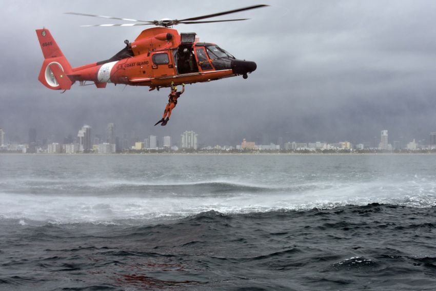
Coalition Tech-Ops Presentation
     John Shea, Helicopter Association International
     Sai Kalyanaraman, Ph.D., Collins Aerospace

7/1/2021                                               5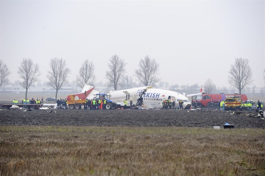
What is a Radar Altimeter?
• Radar altimeters are the only device on the aircraft that can directly measure the
  distance between the aircraft and the ground and only operate in 4200-4400
  MHz
• Operate when the aircraft is on the surface to over 2500’ above ground

   Radar Altimeter Antennas                                                  Radar Altimeter Antennas
                              Photo credit: Honeywell   Photo credit: ALPA

7/1/2021                                                                                           6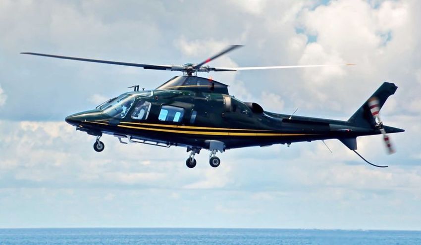
How Does a Radar Altimeter Work?
1. The radar altimeter
   transmits a signal toward
   the ground
2. The signal bounces off the
   ground
3. The radar altimeter
   receives the reflected       1       3
   signal
4. Round-trip time is
                                    2
   translated into distance
                                            Photo credit: Garmin

7/1/2021                                                      7
How Does a Radar System Differ From a
Communication System?
• In a communications system, a receiver
  listens for signals that are generated by
  a transmitter and sent directly to the
  receiver.
           •   Transmit power can be increased to
               compensate for local conditions
• In a radar system, a receiver is listening
  for a transmitted signal that has reflected
  from an object or terrain
     • Transmit power is generally fixed and operates
       over a wide frequency range (up to 200 MHz)
     • Type of reflective surface can cause the return signal to vary widely in strength. The receiver must be very
       sensitive to receive signals reflected from tall grass, plowed fields, water/waves, snow, ice, etc.
     • Achieving this increased sensitivity means that radar receivers are inherently more sensitive to interference
       from strong signals in adjacent bands

7/1/2021                                                                                                        8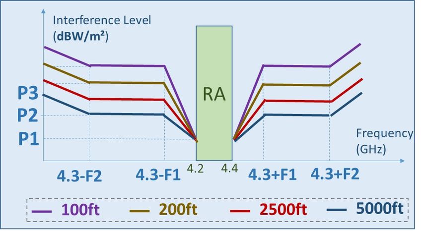
How Does Radar Altimeter Information Get
 Used?
• Radar altitude is shown directly to the
  pilot during approach and landing
    • Essential to safe operation during heavy
      workload, and the pilot needs absolute trust
• In addition, multiple other systems on the
  aircraft are fed the information directly:
    • Flight Controls
             • Automatic Landing
                                                        Photo credit: Radio Nederland Wereldomroep, CC BY 2.0
             • Advanced Aircraft Flight Control Modes   Turkish Airlines 1951 crashed at AMS, in part due to
    • Terrain Awareness and Warning Systems                 a false radar altitude reading, which caused
             • Aircraft                                   autothrottle to go to idle at inappropriate altitude
             • Helicopters
    • Other Warning Systems and Aircraft Systems

  7/1/2021                                                                                                       9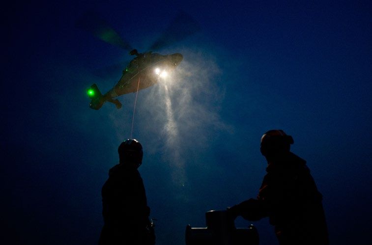
Radar Altimeter Use on Helicopters
• Helicopters operate at low altitudes in an even
  more challenging environment than airplanes
     • Approaches to random points-in-space and
       hospitals
            • Below fixed-wing obstacle protection surfaces
     • Congested urban areas
            • Radar altimeter critical for sling load operations / tall
              building construction
     • Search-and-Rescue and Medevac
            • Terrain / buildings / obstacles
     • Offshore platforms in all weather
            • Platforms will also be equipped with 5G wireless
• Erroneous radar altimeter readings have been
  causes of numerous incidents/accidents

 7/1/2021                                                                 10
Scenario 1a: Airliner or GA Visual Approach and
Landing – Illustrative Example of Some RA Functions
Even in good weather flying, without use of the autopilot, the
radar altimeter is used for many important functions, such as:
1
2
1 At 2500’, radar altitude display active
3
2 At 2300’, Predictive Wind Shear activates (deactivates at 50’)
4
From 1550’ – 1000’, Traffic Alert Collision Avoidance System (TCAS) alerts change 5
3 At 900’ TCAS Resolution Advisories are inhibited (not shown due to lower priority) 6
At/below about 800’, many status and caution messages are inhibited to prevent distraction during
4
landing; other warnings may be enabled at these altitudes (e.g. landing gear not down). (Note: similar
warning changes during takeoff)
5 At 200’, “rising runway” symbol and landing visual cues are shown on flight instruments and Heads-Up Display /
automatic altitude callouts to touchdown – e.g., 50, 40, 30, 20, 10 and “rising runway” animation
At about 100’, some aircraft may transition to a “Flare and De-rotation” flight control law for enhanced handling qualities. Radar
6 altitude is also used in the arming and activation of ground spoilers, thrust reversers, and other landing systems
For Illustrative Purposes – not all uses of radar altitude in airliner or GA visual approaches are described; the exact systems and altitudes vary by aircraft typeScenario 1b: Airliner or GA AUTOLAND,
Visual or Low Visibility “CAT II/III”
1
Radar altimeter functions in addition to all of the
items from the Visual Approach Scenario 1a:
2
Prior to approach, pilots select the approach in 3
1 the Flight Management System – includes
“Decision Height” (e.g. 100’ radar altitude)
4
Selecting a different approach is disabled below a certain radar altitude;
2 manual tuning of the ILS system may be locked out below certain radar altitudes
5
6
Once a CAT II Autoland approach starts, loss of radar altimeter data usually requires the approach to
3 be abandoned (missed approach)
4 Autopilot sensitivity on ILS beam reduces with radar altitude, as ILS Localizer beam width narrows
5 At the specified Decision Height, the pilot must have the runway touchdown zone in sight or execute a missed approach
6 AUTOLAND will transition to Flare and Rollout modes at about 100’ radar altitude.
For Illustrative Purposes – not all uses of radar altitude during AUTOLAND or CAT II/III approaches are described; the exact systems and altitudes vary by aircraft typeScenario 2: Windshear Encounter
and Escape
• Windshear is a weather phenomenon that causes aircraft
to experience a rapid decrease in airspeed, due to wind
flows near the ground
• Hazardous during takeoff and landing.
• Upon encountering a windshear, the Pilot Flying executes
an “escape maneuver”: pitch to a nose-up attitude, and
increase engines to full power
• Aircraft can still lose altitude during the escape maneuver
Windshear
• The Pilot Monitoring continuously calls out radar altitude Warning
to give the Pilot Flying critical situational awareness to
help with decision making to avoid ground contact
• Loss of, or incorrect radar altitude would greatly impair a Radar Altitude
successful safe outcome Display
7/1/2021 13
Image Credit:
AirbusAirliner Interference Hazards
• Each use of the altimeter has a functional hazard
assessment
• Hazards for loss of or erroneous altitudes vary by application
• Hazards range from ‘Major’ to ‘Catastrophic’ depending on phase
of flight
• Hazards from multiple affected functions could occur
simultaneously and combine
7/1/2021 14Scenario 3: Helicopter SAR Operation
Helicopter operations often
deal with demanding
environmental factors
• Typically Entire Flight at Low Altitude
• Day/Night Conditions
• Weather
• Unfamiliar Areas
• Obstacles
• Time Critical
Radar Altimeters feed a wide array of data/control systems
designed to enhance safety:
• GPWS/HTAWS • Aural Safety Warnings § 135.160 – Operable Radio Altimeters Required for Part 135
• TCAS • Descent Operations
• Auto Pilots & Automatic Flight Control Systems • Flight displays §135.605 – HTAWS Required by Regulation for all Helicopter Air
Ambulance Operations
• Flight Directors – Including approach/hover modes
7/1/2021 15Scenario 3: Helicopter SAR Operation
Radar Altimeter interference can result in lost/inaccurate/erroneous/unreliable
data that will be DETECTED or UNDETECTED:
___________Detected___________
________Undetected______
_
Hazardous flight profiles
Increased risk to aircrews CFIT
Loss of situational awareness Loss of aircraft control
Increased crew workloads
Distraction
Loss of mission
Response to Detected Interference Effectiveness of Actions
Situational – dependent on flight operations/environment No equivalent replacement for loss
Actions driven by risk-based analysis of altitude data
May be driven by company SOP or Regulation Asking crews to operate at risk
Final response may range from continued flight to abort mission
7/1/2021 16Where Can I Find More Information?
• The RTCA published a report in October 2020: “Assessment of C-Band Mobile
Telecommunications Interference Impact on Low Range Radar Altimeter
Operations”
• Section 5.3 describes specific aircraft systems that depend on radar altimeter information, and
the effect of radar altimeter interference on those systems
• https://www.rtca.org/wp-content/uploads/2020/10/SC-239-5G-Interference-Assessment-
Report_274-20-PMC-2073_accepted_changes.pdf
7/1/2021 17RTCA/EUROCAE Current Status
Sc-239/WG-119 Low Range Radar Altimeters
Jean-Luc Robin, Airbus
Seth Frick, Honeywell
7/1/2021 18RTCA Report: methodology and conclusion
Methodology
RTCA Report concluded that 5G operations present a risk of harmful interference to at least
some heavily deployed RAs across a wide variety of aircraft types, with far-reaching
consequences and impacts to aviation operations
"(c) 2021 EUROCAE, (c) 2021, RTCA, Inc."RTCA Report: Scope and Limitations
The receiver ITMs (Interference Tolerance Masks) for each of the 3 Usage Categories
used in the RTCA Report were based on aggregated measurements from multiple
widely-used RA models in each category. Therefore, while at least some RA models
would be susceptible to 5G interference, this may not be true for all models. Evaluation
of individual RA models was outside the scope of the RTCA report, since this was not
necessary to determine whether or not a risk of harmful interference exists
The 5G signals and operations were characterized as follows:
- Waveform used for interference tolerance testing: 3GPP Test Model 1.1, with 30 kHz
subcarrier spacing and 100 MHz channel bandwidth. This is expected to be a reasonable
worst-case, but many other waveform configurations are possible, and network dynamics
will play a significant role in the interference levels seen in the real world.
- 5G operational parameters such as base station antenna patterns and scan angles for
active phased array antenna systems were based on nominal implementations anticipated
by wireless industry engineers. Off-nominal conditions, and potential future applications with
different characteristics, were not evaluated.
- Only a single 5G base station (with 50% downlink duty cycle) was considered. Scenarios
with multiple 5G base stations were not evaluated.
- 5G fundamental emissions and 5G spurious emissions (within the 4.2–4.4 GHz band) were
evaluated separately. In the real world, both will be present simultaneously.
"(c) 2021 EUROCAE, (c) 2021, RTCA, Inc."MOPS WAY FORWARD
5G – AERO collaboration proposal Aircraft
operational
Aggregated Power Flux Density scenarios
5G operating rules/regulations
(emissions limits, frequency (dBW/m²/MHz) for arbitrary points
bands, spurious limits, etc.) in space where aircraft may MOPS RA receiver Mask per
operate altitude (ITM)
5G Experts RTCA/EUROCAE
from MOPS Special
wireless 5G Waveform
Comittee
industry SC239/WG119
5G modeling
tools - Note1: Fixed Wing aircraft mask could differ
from helicopter mask
- Note2: Receiver masks will account for all
Existing Accuracy Realistic worst- known interference sources near the RA
Realistic worst-case 5G signals
interference criteria case RA band, which may be more than just 5G
scenario sources operating - Note3: ITM in the MOPS is expected to be
- Several UEs onboard the aircraft? valid for the next 30 years
- Aircraft crossing a 5G BS AAS beam
(Ownship conditions
created by several UEs in the direction of RA…) (terrain
the aircraft ? reflectivity, Legend
- Max. scan angle above the horizon for aircraft pitch/roll, Aviation industry
active phased array base stations? etc.) needs help and
- Worst-case secondary lobes directed collaboration from
above the horizon in base station antenna 5G experts
patterns? "(c) 2021 EUROCAE, (c) 2021, RTCA, Inc."Industry way forward
Continued Airworthiness wrt in-service events with existing equipment (aviation
STREAM
authorities)
1
Short Term Mitigations
STREAM (e.g: 5G restrictions around airports, aircraft operational Decisions made
restrictions, aircraft retrofits… ?)
2 based on the
Classification of
Potential Decision
the criticality and
Update
urgency
MOPS RA receiver Mask
per altitude (ITM)
Input RTCA Behavior of RA Impact at
STREAM from MOPS output (RA
aircraft
delivery manufacturers)
3 5G level
YEARS
1st July 2021 ? End 2022 2023 >30 years
MOPS release
"(c) 2021 EUROCAE, (c) 2021, RTCA, Inc."
planCONCLUSION
1. RTCA/EUROCAE MOPS is focusing on Radio Frequency
Coexistence with 5G
a) Additionally, new MOPS will improve standardization and documentation
of key Rad Alt performance characteristics needed for future coexistence
evaluation
2. RTCA/EUROCAE MOPS will be released once the ITM is
agreed within aeronautical community. The ITM will be defined
once the 5G aggregated level is defined. The target release date
is Q4 2022.
3. There is a need to get the 5G aggregated level from 5G
community in order to build the MOPS on validated, sound,
resilient and long-term assumptions.
a) This same effort helps with the development of near-term mitigations as
well, not just the long-term solution (new MOPS). "(c) 2021 EUROCAE, (c) 2021, RTCA, Inc."Fixed Wing Perspective
Ben Ivers, The Boeing Company
7/1/2021 24Fixed Wing Perspective
• Airframe OEM’s support 5G and its deployment
• The aviation industry (including UAS/AAM) expects to be a big user of 5G
• Harmonization is key to ensure public safety and to ensure Aviation / Telecom joint success
• There is variation in the interference effect on aircraft. Variation depends upon:
• Level of integration of the radio altimeter with other aircraft systems
• Radio altimeter model number
• Crew workload in specific phases of flight
• External environment
• Preliminary safety analyses of airplane level effects of interference are
consistent with RTCA report:
• Under specific conditions, interference could result in hazards levels up to and including
catastrophic
7/1/2021 25Fixed Wing Perspective
• Some radio altimeters should be resilient to 5G signals while others will need
upgrades
• Confirmation needed once RTCA global threat characterization is complete
• Collaboration with 5G industry is needed to validate 5G assumptions
• Radio altimeter updates will take time to be incorporated
• There is a need for near-term mitigations in the form of 5G implementation
guidance
• These mitigations would be temporary until updated MOPS and altimeters are available
• These mitigations will ensure public safety while long-term solutions are put in place
7/1/2021 26Radio Altimeter Rotorcraft
Modes and Hazards
Nick Kefalas, Lockheed Martin Sikorsky
7/1/2021 27Radio Altimeter Rotorcraft Modes and Hazards 7/1/2021 28
Radio Altimeter and the
      Modern Flightdeck
      Wes Googe, American Airlines

7/1/2021                             29
Flight Crew Requirements
• Knowledge
• National Airspace System
• Aircraft Systems and Procedures
• Skillset
• Judgement
• Training
• Experience
7/1/2021 30Flight Crew Dependencies • Standard Operating Procedures • Aircraft Basic System Reliability • Navigation Data Accuracy and Integrity • Aircraft Safety System Reliability and Integrity 7/1/2021 31
Radio Altimeter Integration
• Flight Operations Use
           • Safety of Flight Items
              • Approach Minimum
              • Terrain Avoidance
              • Aircraft Collision Avoidance
              • Wind Shear Avoidance
              • Aircraft Operating Envelope Protection
              • Navigation, Warning System Functionality
              • Auto Land Operations

7/1/2021                                                   32
Radio Altimeter RFI
• Flight Crew Aircraft Concerns
• No RFI Detection Capability
• Loss or Degradation of Certain Safety Systems
• Unplanned/Unintended Aircraft Operation
• Flight Crew Operation Concerns
• Approach Success Uncertainty
• Significant Reduction in Safety During WX or Terrain Events
• ATC Mitigation
• Loss of Low Visibility Runway Operations
• Reduced Airport Access
7/1/2021 33Summary
• Aircraft Operational Impacts
• Under Review
• Training Preparation
• Under Review
• Flight Operational Consequences
• Under Review
7/1/2021 34Mitigating Radio Altimeter
Interference: Restoring Safety and
Operational Integrity
Robert Ireland, Airlines for America
7/1/2021 35Mitigating Radio Altimeter Interference:
Restoring Safety and Operational Integrity
• Detailed characterization of expected issues, iterated by real-world findings
• Revised/new system designs (3-5 years)
• For ALL aircraft types that are susceptible, starting ASAP
• Certification and STC approvals (months to years for all aircraft models and new
or revised LRUs)
• Procurement cycle
• Installation (3-5 years of major airlines, unless otherwise mandated)
• Dependent on extent of mods (i.e., LRU, +writing?,+antennae changes??)
• Maintenance visit coordination (routine or special routing?)
7/1/2021 36You can also read