Proposed Filling Station on Erf 38333 Transport Impact Assessment (TIA) Richmond Park, Milnerton - SLR Consulting
←
→
Page content transcription
If your browser does not render page correctly, please read the page content below
Proposed Filling Station on Erf 38333

                                       Transport Impact Assessment (TIA)

                                               Richmond Park, Milnerton
                                                         Report Status – Revision 1
                                                                        April 2021

5th Floor

Imperial Terraces

Carl Cronje Drive

Tyger Waterfront

Bellville, 7530

Tel. 021 914 6211

e‐mail: westerncape@itsglobal.co.za
Proposed Filling Station on Erf 38333                                                                           April 2021
Revision 1                                                                                                       ITS 4330

                                                    SUMMARY SHEET

 Report Type                      Transport Impact Assessment (TIA)

 Title                            Proposed Filling Station on Erf 38333

 Location                         Richmond Park, Milnerton

 Client                           Richmond Park Development Company (Pty) Ltd

 Reference Number                 ITS 4330

 Project Team                    Christoff Krogscheepers – Christoff@itsglobal.co.za
                                 Hugo Engelbrecht – Hugo@itsglobal.co.za
                                 Theodore Neels – Theodore@itsglobal.co.za

 Contact Details                 Telephone: 021 914 6211

 Date                             April 2021

 Report Status                    Revision 1

 File Name                        G:\4330\12 Reports\issue\4330_Erf38333 FillingStation Milnerton_TIA_HE_2021 04 01.docx

INNOVATIVE TRANSPORT SOLUTIONS (PTY) LTD                                                                            Page i
Proposed Filling Station on Erf 38333                                                                                                        April 2021
Revision 1                                                                                                                                    ITS 4330

                                                          Table of Contents
1      Purpose of Study ............................................................................................................................. 1
2      Locality and Extent .......................................................................................................................... 1
3      Existing Roadways ........................................................................................................................... 1
4      Existing Access ................................................................................................................................ 1
5      Study Intersections and Existing Control ........................................................................................ 2
6      Analyses Hours ................................................................................................................................ 2
7      Scenarios Analysed ......................................................................................................................... 2
8      Existing Traffic – Scenario 1 ............................................................................................................ 3
9      Approved / In‐ Process Developments ........................................................................................... 4
10 Background Traffic Scenario 2 ........................................................................................................ 4
11 Trip Generation and Development Trips ........................................................................................ 5
12 Trip Distribution .............................................................................................................................. 7
13 Site Access ....................................................................................................................................... 7
14 Total Traffic – Scenario 3................................................................................................................. 8
15 Non‐Motorised Transport ............................................................................................................... 8
16 Public Transport .............................................................................................................................. 9
17 Parking .......................................................................................................................................... 10
18 Site Circulation .............................................................................................................................. 10
19 Future Road Network.................................................................................................................... 10
20 Conclusion & Recommendations .................................................................................................. 11

                                                               List of Tables

Table 1: Filling Station – Traffic Volumes (Background Traffic)                                                                                        6
Table 2: Filling Station – Expected Trips (3% Capture Rate)                                                                                            6
Table 3: Convenience Store – Trip Generation                                                                                                           6
Table 4: Convenience Store – Trip Generation (Continued)                                                                                               6
Table 5: Convenience Store – Expected Development Trips                                                                                                6
Table 6: Total Trips – Filling Station PLUS Convenience Store                                                                                          7
Table 7: Parking Required                                                                                                                            10

Annexure
Annexure A:             Figures

INNOVATIVE TRANSPORT SOLUTIONS (PTY) LTD                                                                                                         Page ii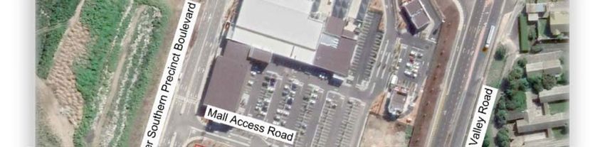
Proposed Filling Station on Erf 38333                                                                     April 2021
Revision 1                                                                                                 ITS 4330

                               Transport Impact Assessment
             Proposed Filling Station on Erf 38333, Richmond Park, Milnerton

                                  This study summarises an investigation of the transport impacts, expected as
                                  part of a filling station development planned on Erf 38333, in the Richmond
                                  Business Park, Milnerton. This report forms part of an application to obtain
1 Purpose of Study                development rights for this development.

                                  The purpose of this investigation is to identify potential constraints within the
                                  surrounding road network and to recommend appropriate mitigation
                                  measures, to ensure that acceptable future operations would be maintained.

                                  This development is planned on Erf 38333 in Milnerton, which is located in
                                  the north‐east quadrant of the Plattekloof Road / Upper Southern Precinct
                                  Boulevard intersection, within the Richmond Business Park.

                                  Existing Use: Vacant Erf
2 Locality and Extent
                                  Future Use: A filling station with five (5x) pump islands (10x pump bays) and
                                  a 330m2 total Gross Leasable Area (GLA) convenience store is proposed.

                                  See Figure 1 for a Locality Plan and Figure 2 for the Site Development Plan
                                  (SDP).

                                  The major roadways in the site vicinity include:

                                  Plattekloof Rd is a Class 2 Major Arterial road, with two lanes per direction
                                  separated by a median island. There is a sidewalk and cycle lane on the
                                  northern side‐ and a shoulder plus a sidewalk on the southern side.

                                  Tygerberg Valley Rd is Class 4 Collector, with two lanes per direction, with
                                  cycle lanes and sidewalks on both sides of the road, south of the Carmine
3 Existing Roadways
                                  Road / Lionel Solomons Boulevard intersection.

                                  Upper Southern Precinct Boulevard is a typical Class 5 road, with one lane
                                  per direction from the left‐in, left‐out access along Plattekloof Road, which
                                  opens up to two lanes per direction further north. There are sidewalks along
                                  both sides of this road.

                                  See Figure 1 for the location of these roads, relative to the development.

                                  There is currently no formal access to this site. See Section 13 of this report,
4 Existing Access
                                  for a discussion on the proposed future access/es.

INNOVATIVE TRANSPORT SOLUTIONS (PTY) LTD                                                                     Page 1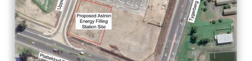
Proposed Filling Station on Erf 38333                                                                          April 2021
Revision 1                                                                                                      ITS 4330

                                  Int.1: Plattekloof Road / N7 Western Terminal…..………………………..[Signalised]
                                  Int. 2: Plattekloof Road / N7 SB Loop On‐Ramp….……….……………..…[Free Flow]
                                  Int.3: Plattekloof Road / N7 Eastern Terminal..…………………………….[Signalised]
                                  Int.4. Plattekloof Road / Upper Southern Precinct Blvd…….…[Left‐in, Left‐out]
                                  Int.5: Plattekloof Road / Tygerberg Valley Road……………………....[Roundabout]
                                  Int.6: Tygerberg Valley Road / Southern Precinct Blvd…….…….[Partial Access]
5 Study Intersections
                                  Int. 7: Tygerberg Valley / Carmine / Lionel Solomons......................[Signalised]
  and Existing Control
                                  Int. 8: Tygerberg Valley Road / Burgundy Drive………………..………..…[Signalised]
                                  Int. 9: Upper Southern Precinct Blvd / Filling Station Exit………..[Future Access]
                                  Int. 10: Upper Southern Precinct Blvd / Mall Access……………..…..[Priority Stop]
                                  Int. 11: Mall Access / Filling Station Access……….…………………...[Future Access]

                                  See Figure 3 for the locations of these study intersections, as well as a
                                  schematic illustration of the intersection geometry and control.

                                  Weekday AM peak hour (Surveyed peak hour 06:45 to 07:45)

6 Analyses Hours                  Weekday PM peak hour (Surveyed peak hour 16:30 to 17:30)

                                  The peak hours were determined from the peak period traffic counts.

                                  Scenario 1: 2021 Existing Traffic conditions. Based on 2021 traffic counts,
                                  escalated with a growth rate (13%/2% AM/PM), PLUS an additional two
                                  percent growth rate per year over two years, to compensate for the lower
                                  than “normal” traffic volumes, due to the impact of Covid19 Lockdown
                                  Level 1 on traffic flows. See Section 8 of this report for more details.

                                  Scenario 2: 2024 Background Traffic conditions. Based on Scenario 1 traffic
                                  volumes, escalated with a two percent growth rate over three years PLUS the
7 Scenarios Analysed              trips from other approved / in‐process developments added onto the
                                  surrounding road network. See Section 10 in this report for more details.

                                  Scenario 3: 2024 Total Traffic conditions. Based on Scenario 2 traffic
                                  volumes, PLUS the trips from the proposed filling station. See Section 14 of
                                  this report for more details.

                                  Intersection analyses were done with Traffix version 8.0 Software, which is
                                  based on the Highway Capacity Manual (HCM).

INNOVATIVE TRANSPORT SOLUTIONS (PTY) LTD                                                                          Page 2
Proposed Filling Station on Erf 38333 April 2021
Revision 1 ITS 4330
Peak hour traffic counts were done on Tuesday, 23 February 2021 during the
Covid‐19 Level 1 lockdown period. These 2021 counts were compared with
Sept. 2019 traffic counts and found to be 13% and 2% lower than the 2019
traffic counts, for the weekday AM‐ and PM peak hours respectively. Hence,
the 2021 counted traffic volumes were escalated with these growth rates,
PLUS an additional two percent growth rate was added per year over the two‐
year period, to determine the calculated 2021 Existing Traffic volumes.
These 2021 traffic counts were done, to identify changes in traffic patterns
and turning movements at intersections since 2019, due to changes in the
road network, such as the completion of the Giel Basson Drive link
(completed mid‐2020). This calculated 2021 peak hour traffic volumes was
used for the Existing Traffic capacity analyses.
Site visits was also done in March 2021, during the peak traffic periods. The
following was observed during these site visits:
Plattekloof Roundabout: The southbound right‐turn movement were
relatively busy during the AM peak period, although the roundabout
operated acceptably.
A number of cyclist were observed along Tygerberg Valley Road / De
8 Existing Traffic – Grendel Road, through the Plattekloof roundabout.
Scenario 1
The 2021 Existing Traffic conditions are based on the calculated traffic
volumes as well as the existing intersection geometries and controls. Based
on the Existing Traffic capacity analysis results, the following are concluded:
Most study intersections currently operate acceptably. However, the
following intersection experiences constraints and require upgrades:
Int. 1 Plattekloof Road / N7 Western Terminal: currently operates at
unacceptable Levels‐Of‐Service LOS E / F, delays greater than 50 seconds and
Volume‐to‐Capacity (v/c) ratios of 86% / 97% during the AM / PM peak hours
respectively. Relatively long delays and queues are experienced on the
north‐ and eastbound approaches of this intersection.
Recommended Upgrades: Based on communication received from the
Western Cape Government, the Refinery Interchange upgrade is scheduled
to commence in September 2021. These upgrades will include the following,
as illustrated schematically on Figure 4C:
Eastbound – a separate left‐turn lane plus two through lanes.
Westbound ‐ a separate right‐turn lane plus two through lanes.
Northbound – two right‐turn lanes plus a left‐turn slip lane.
Operations after Upgrade: Acceptable Levels‐Of‐Service A / B.
INNOVATIVE TRANSPORT SOLUTIONS (PTY) LTD Page 3
Proposed Filling Station on Erf 38333 April 2021
Revision 1 ITS 4330
As part of this Refinery Interchange upgrades, the Plattekloof Road / N7
Eastern Terminal will also be upgraded, to include the following:
Eastbound – two through lanes.
Westbound – two left‐turn slip lanes plus two through lanes.
Southbound – separate left‐ and right turn lanes.
Operations after Upgrade: Acceptable LOS A during both peak hours.
See Figure 4A/B for the 2021 Existing Traffic volumes and operations
summary for the weekday AM and PM peak hours respectively. Also see
Figure 4C for the operations after the Refinery Interchange upgrades.
The trips from the following Approved / In‐Process developments were
included in the Background‐ and Total Traffic conditions scenarios:
CTM, Erf 38308
CFC, Erf 38310
RPP, Erf 38313
Panorama Light Industrial Park, Erf 38320 (4 Lease Areas)
Hume, Erf 38317
Sales Office / RPMPOA Office, Erf 38239
9 Approved / In‐ Mustek Development, Erf 38311
Process Future Development Rem Erf 38235
Developments Richmond Corner, Erf 38332
ACDC Dynamics, Rem Erf 38234 (Lease Area)
Corex, Rem Erf 38234 (Lease Area)
Astron Energy, Rem Erf 38236
Aramex, Erf 38345
Get Worth, Erf 38331
Takealot Rem Erf 38394 (Lease Area)
These Approved / In‐Process developments are expected to generate an
additional 1 356 peak hour trips, on the surrounding road network.
The 2024 Background Traffic volumes were calculated by applying a two
percent growth rate per year over a three‐year period, to the calculated 2021
Existing Traffic volumes, PLUS the trips from the other approved / in‐process
10 Background developments, as summarised in Section 9 of this report.
Traffic Scenario 2
The analysis in this scenario is based on the existing intersection geometries
and control, plus the upgrades planned at the Refinery Interchange, as
discussed in Section 8 of this report.
INNOVATIVE TRANSPORT SOLUTIONS (PTY) LTD Page 4Proposed Filling Station on Erf 38333 April 2021
Revision 1 ITS 4330
Based on the 2024 Background Traffic capacity analyses, all study
intersections would continue to operate at acceptable Levels‐Of‐Service,
with the existing geometry plus the upgrades planned at the Refinery
Interchange. Hence, no additional road upgrades are required or proposed
for the 2024 Background Traffic conditions, from an intersection capacity
point of view.
See Figure 5 for a summary of the expected 2024 Background Traffic volumes
and operations.
Filling stations mostly intercept / capture pass‐by / diverted trips that are
already on the road network surrounding a site. Although some (nett‐) new
trips are also expected, this percentage is typically relatively low for filling
stations. The pass‐by / diverted‐, nett‐new and total trips for this
development was calculated as follows:
The South African Trip Generation Rate (SATGR) manual
recommends a 4 percent total capture rate of traffic volumes on the
surrounding road network, and recommends that 16 percent of this
total captured volume are net‐new trips. The above percentages and
recommendations are based on old data. Hence, a rethink of these
percentages is proposed, as agreed by CoCT officials.
The following methodology was used to calculate this filling station
development trips:
o The Filling Station and Convenience Store trips were calculated
separately.
11 Trip Generation o Filling station = apply a 3% total capture rate (Based on the 2001
and Development Paper “Revision of the Guidelines for Access to Filling Stations in
Trips the Greater Pretoria Area”). All filling station trips to be
evaluated as pass‐by / diverted trips.
o Convenience Store = The total GLA of the C‐Store is 330m2.
However, the trip generation is based on the retail floor space
only (i.e. 200m2 rounded value). The office, storage, ablutions
facilities, ATM and refuse areas were included as part of the filling
station trips, as agreed with CoCT officials. The relevant pass‐by
(13%) and diverted (29%) percentages were also applied.
o Shared Trips = since the trips are calculated separately for the
different land‐uses and since some shared trips are expected, a
10.4% shared trip reduction factor is recommended. (Based on
the 2001 Paper “Revision of the Guidelines for Access to Filling
Stations in the Greater Pretoria Area”).
Based on the above methodology, this Filling Station and Convenience Store
is expected to generate the following peak hour (pass‐by / diverted / nett‐
new and total) vehicle trips:
INNOVATIVE TRANSPORT SOLUTIONS (PTY) LTD Page 5Proposed Filling Station on Erf 38333 April 2021
Revision 1 ITS 4330
Table 1: Filling Station – Traffic Volumes (Background Traffic)
A.M. Peak P.M. Peak
Road Description
Total Captured Total Captured
Plattekloof Road 1030 31 1430 43
Upper Southern Precinct Blvd. 105 4 100 3
Richmond Corner Mall Access 245 8 580 18
TOTAL 54 84
Table 2: Filling Station – Expected Trips (3% Capture Rate)
AM Peak Hour PM Peak Hour
Road Description
In Out Total In Out Total
Plattekloof Road 31 31 62 43 43 86
Upper Southern Precinct Blvd. 4 4 8 3 3 6
Richmond Corner Mall Access 8 8 16 18 18 36
TOTAL 43 43 86 64 64 128
Table 3: Convenience Store – Trip Generation
Size/
Land Use Units Source
Volume
Convenience Store m2 CoTO820 200
Note: The total GLA of the C‐Store is 330m2. However, the trip generation is based on the retail
floor space only (i.e. 200m2 rounded value). The office, storage, ablutions facilities, ATM and
refuse areas were included as part of the filling station trips, as agreed with CoCT officials.
Table 4: Convenience Store – Trip Generation (Continued)
Weekday AM Peak Hour Weekday PM Peak Hour PM ONLY
Pass‐ Diverted
Rate In Out Rate In Out
By's Trips
4,01 65% 35% 22,07 50% 50% 13% 29%
Table 5: Convenience Store – Expected Development Trips
Land Use Weekday AM Peak Hour Weekday PM Peak Hour
Convenience Store In Out Total In Out Total
Pass‐By Trips 0 0 0 3 3 6
Diverted Trips 0 0 0 7 7 13
Nett‐New Trips 5 3 8 13 13 26
Total Trips 5 3 8 23 23 45
With the 10.4% shared trip reduction factor, this development will capture /
generate the total number of trips as illustrated in Table 6 below, for the
filling station plus convenience store:
INNOVATIVE TRANSPORT SOLUTIONS (PTY) LTD Page 6Proposed Filling Station on Erf 38333 April 2021
Revision 1 ITS 4330
Table 6: Total Trips – Filling Station PLUS Convenience Store
Weekday AM Peak Hour Weekday PM Peak Hour
Trip Type
In Out Total In Out Total
Pass‐By / Diverted Trip 38 38 76 68 68 136
Nett‐New Trips 4 3 7 12 12 24
Total Trips 42 41 83 80 80 160
From the above table, this development is expected to intercept / generate
83‐ / 160 total trips during weekday AM / PM peak hours respectively.
The majority of these trips will be intercepted / captured trips, with only a
few nett‐new trips being generated by the convenience store. This
development is expected to generate 24 total nett‐new trips during the
weekday PM peak hour and only 20 nett‐new trips when including the
15% Public Transport reduction, as agreed with CoCT officials.
See Figure 6 for the expected intercepted / generated development trips and
the distribution of these trips through the surrounding road network.
The following trip distribution was used for the C‐Store nett new trips:
20% of trips to / from the south along De Grendel Avenue.
20% of trips to / from the east along Plattekloof Road
30% of trips to / from the west along Plattekloof Road
5% of trips to / from the east along Carmine Drive
12 Trip Distribution 5% of trips to / from the east along Burgundy Drive
5% of trips to / from the east along Sienna Drive
15% of trips to / from the north along Tygerberg Valley Road
The pass‐by, diverted and interception trips will occur based on the existing
peak hour traffic patterns experienced along the surrounding road network.
See Figure 6 for a graphic illustration of this expected trip distribution.
Two accesses are proposed as part of this filling station development:
A Full Access ‐ from the Mall Access Road, approx. 25 meters east of
Upper Southern Precinct Blvd. A dedicated eastbound right‐turn lane
is recommended from this access road, into the filling station.
13 Site Access A left‐out only exit to Upper Southern Precinct Blvd, approx.
30 meters north of Plattekloof Road.
See Figure 2 for the locations of these accesses and Figure 7 for a schematic
illustration of the lane configurations and controls at these accesses.
INNOVATIVE TRANSPORT SOLUTIONS (PTY) LTD Page 7Proposed Filling Station on Erf 38333 April 2021
Revision 1 ITS 4330
The 2024 Total Traffic volumes were calculated by adding the expected filling
station development trips (including pass‐by, diverted, intercepted and nett‐
new trips) to the 2024 Background Traffic volumes.
The geometry used in this scenario is based on the existing intersection
geometries (see Figure 3), plus the upgrades planned at the Refinery
Interchange (See Figure 4C), plus the access / intersection upgrades
recommended as part of this filling station development. (See Figure 7).
Based on the capacity analyses results, all the study intersections are
14 Total Traffic –
expected to continue to operate at acceptable levels‐of‐service, during the
Scenario 3
peak hours analysed. Hence no additional upgrades are required as part of
the filling station development.
However, a single lane roundabout is proposed at the Upper Southern
Precinct Blvd. / Mall Access Road intersection, to ensure acceptable long‐
term operations. This intersection would operate acceptably as part of the
filling station development with the existing geometry and control, but this
upgrade is proposed, to mitigate disruption of traffic flow in the future.
See Figure 8 for the 2024 Total Traffic volumes and operations
Existing Facilities: Plattekloof Road is a Class 3 cycle route and Tygerberg
Valley Road is a Class 4 cycle route, according to the City of Cape Town’s NMT
network plan. See Figure 9 for an extract from this CoCT plan.
The following facilities are currently available in the immediate site vicinity:
Sidewalks along both sides of Upper Southern Precinct Blvd, along
both sides of Plattekloof Road, along both sides of Tygerberg Valley
Road, and along the northern side of the Mall Access Road.
Cycle lanes along both sides of Tygerberg Valley Road / De Grendel
Road as well as along Plattekloof Road from the Refinery Interchange
Eastern Terminal to Upper Southern Precinct Boulevard, along the
15 Non‐Motorised northern side of the road. The relative wide shoulders along the
Transport remainder of Plattekloof Road are also used as bicycle lanes.
Pedestrian crossing at the Upper Southern Precinct Blvd / Southern
Precinct Blvd roundabout, at the Plattekloof / Tygerberg Valley
roundabout and across Upper Southern Precinct Blvd, north of the
Mall (and future filling station) access.
There are median islands along most of the study roads in the site vicinity,
which enable pedestrians / cyclist to cross one traffic stream at a time. See
Figure 10 for the locations of these existing pedestrian / cyclist facilities.
During the site visits it was observed that some cyclist and pedestrians use
these facilities. The existing hourly pedestrian‐ and cyclist volumes are
illustrated on Figure 11.
INNOVATIVE TRANSPORT SOLUTIONS (PTY) LTD Page 8Proposed Filling Station on Erf 38333 April 2021
Revision 1 ITS 4330
Proposed Facilities: The following pedestrian facilities will be provided, as
illustrated on Figure 2, the Site Development Plan:
A sidewalk on the southern side of the Mall Access Road.
A walkway between the Mall Access Road and the convenience store
pedestrian access. This walkway would accommodate pedestrian
movements between the parking areas and the convenience store.
A ramp at the disabled parking bay in front of the C‐Store access.
These above proposed facilities together with the existing sidewalks and
cycle lanes in the site vicinity, should be sufficient to accommodate the
expected pedestrian movements to / from this filling station development.
Existing Facilities: See Figure 12 for an extract from the City of Cape Town’s
Public Transport Network Plan. Based on the figure, the following roads in
the site vicinity are currently used as public transport routes:
Tygerberg Valley Road / De Grendel Drive – IRT, Taxi and bus routes.
Plattekloof Road – West of Tygerberg Valley Road are taxi‐ and bus
routes, and East of Tygerberg Valley Road is only a taxi route.
The following facilities are currently available in the site vicinity:
Taxi embayment on the western side of Upper Southern Precinct
Boulevard, just north of the Mall Access Road.
Taxi embayments north and east of the Upper Southern Precinct
Boulevard / Southern Precinct Blvd roundabout.
Taxi embayment east of the Lionel Solomons / Upper Southern
Precinct Boulevard roundabout.
Bus embayments along Tygerberg Valley Road, on the downstream
16 Public Transport side of the Lionel Solomons Drive / Carmine Drive intersection.
A taxi rank (for 10 taxi bays) on‐site at the Mall.
See Figure 13 for the locations of these public transport facilities as well as
surveyed peak hour public transport volumes.
Future Planning: Several additional taxi embayments are going to be
implemented at the downstream side of intersections, as part of the larger
Richmond Business Park internal road network. An IRT facility and service is
also going to be implemented along Tygerberg Valley Road, at the
downstream sides of the Carmine Drive‐ and Burgundy Drive intersections.
Proposed Facilities: The proposed filling station development is not expected
to generate a significant number of public transport trips. The existing and
planned future public transport facilities would be sufficient to accommodate
the expected public transport demand of this development. Hence, no
additional public transport facilities are proposed as part of this filling station
development.
INNOVATIVE TRANSPORT SOLUTIONS (PTY) LTD Page 9Proposed Filling Station on Erf 38333 April 2021
Revision 1 ITS 4330
On‐site parking should be provided according to the rates recommended in
the “Minimum Off‐Street Parking Requirements” from the City of Cape Town.
See Table 7 below for a summary of the required on‐site parking bays:
Table 7: Parking Required
# Bays
Land Use Recommended Parking Rate
Required
17 Parking Filling Station 1 bay / pump (based on 10 pump bays) 10 bays
2 2
Convenience Store 4 bays / 100m (based on 330m GLA) 13 bays
Total 23 bays
Based on the above summary, a min. of 23 parking bays should be provided
on site. According to Figure 2, the Site Development Plan (SDP), 41 parking
bays would be provided. Hence, sufficient on‐site parking would be available.
The on‐site circulation was evaluated. The fuel tanker would enter the site
from the Mall Access Road and it would exit the site via the left‐out exit along
Upper Southern Precinct Boulevard. The offloading to fuel will occur on the
18 Site Circulation
left‐hand side of the truck. The truck movement is illustrated schematically
on Figure 2 the Site Development Plan (SDP). Based on this investigation,
acceptable on‐site circulation would be possible for all vehicles.
Several road link, intersection‐ and interchange upgrades are planned in the
vicinity of this development, as summarised below and shown on Figure 13.
The extension of Giel Basson Drive – (already) completed mid‐2020.
Refinery Interchange (Plattekloof Road / N7 Freeway Terminals) –
Reconstruction scheduled to commence in September 2021.
Extension of Burgundy Drive, between Tygerberg Valley Road and
Koeberg Road, across the N7 Freeway – construction of the section
across Richmond Park to commence before end‐2021.
Dualing of Tygerberg Valley Road, between Carmine Drive and
19 Future Road Burgundy Drive – expected to commence in 2022.
Network Extension of Carmine Drive to the future Blaauwberg Road extension‐
Note, approx. 70% of this road link is already constructed.
New Blaauwberg interchange, including a link road between Koeberg
Road and the re‐aligned Tygerberg Valley Road. – date unknown.
These link upgrades are expected to result in changes to the existing traffic
patterns and distribution. It is likely that once this full road network is in
place, that the traffic volumes along Tygerberg Valley Road could reduce.
However, the remaining development potential in this area might again take
up the available spare capacity, resulting in similar traffic volumes (than
evaluated in this report) along the study road sections.
INNOVATIVE TRANSPORT SOLUTIONS (PTY) LTD Page 10Proposed Filling Station on Erf 38333 April 2021
Revision 1 ITS 4330
This study summarises an investigation of the transport impacts, expected as
part of a filling station development planned on Erf 38333, in the Richmond
Business Park, Milnerton. This report forms part of an application to obtain
development rights for this development. Based on the findings of this
investigation, the following can be concluded:
Land Use / Extent – A filling station with five Pump Islands (10 pump
bays) and a 330m2 Gross Leasable Area (GLA) Convenience Store.
Existing Traffic Conditions – The western terminal of the Refinery
interchange currently operates at unacceptable Levels‐of Service
during the peak hours. Upgrade of this interchange will commence in
September 2021. This interchange would operate acceptably, once
this upgrade in in place.
Background Traffic Conditions – All study intersections are expected
to continue to operate acceptably. Hence, no road upgrades are
required or proposed in this scenario.
Trip Generation – 83‐ / 160 total trips would be captured / generated
during weekday AM / PM peak hours respectively. Only 24 nett‐new
trips would be generated during the PM peak hour or only 20 nett‐new
trips when including a 15% Public Transport reduction, as agreed with
the City of Cape Town officials.
20 Conclusion & Vehicular Access – A full access is proposed from the Mall Access Road
Recommendations and a left‐out only exit is proposed from Upper Southern Precinct Blvd
Total Traffic Conditions – All study intersections are expected to
continue to operate acceptably. Hence, no road upgrades are required
for this scenario. However, a single lane roundabout is proposed at
the Upper Southern Precinct Blvd. / Mall Access Road intersection, to
ensure acceptable long‐term operations.
Pedestrian and Cyclists – The following facilities will be provided:
o A sidewalk on the southern side of the Mall Access Road.
o A walkway between the Mall Access Road and the Convenience
Store pedestrian access.
o A ramp at the disabled parking bay in front of the C‐Store access.
Public Transport – No additional public transport facilities are
proposed as part of the filling station development.
Parking – Sufficient parking would be provided on site.
Site Circulation – Acceptable on‐site circulation would be possible.
Based on this investigation, it is evident that the expected transport impacts
from the proposed filling station development on Erf 38333 could be
sufficiently mitigated, provided that the upgrades as discussed in this report
are in place. Hence, it is recommended that this development be considered
for approval, from a transport point of view.
INNOVATIVE TRANSPORT SOLUTIONS (PTY) LTD Page 11Annexure A Figures
Potsdam
                                              Interchange

                                                                                                         d
                                                                                                 e y Roa
                                                                                              all
                                                                                       e  rg V
                                                                                    erb
                                                                               Tyg
                           N7 National Road
      d
  Roa
 berg
Koe

                                                                                          Gie

                                                              Proposed
                                                                                           l Ba

                                                            Filling Station
                                                                                            sso

                                                            Development
                                                                                                nD
                                                                                                  rive

             Refinery                                          Platte
           Interchange                                               kloof
                                                                             Road

                                                                                                             SCHEMATIC
          PROJECT:                                          FIGURE:                                          NUMBER:

                 PROPOSED FILLING STATION
                                                                              LOCALITY PLAN
            DEVELOPMENT ON REMAINDER ERF 3833                                                                     1A
                                                                               WIDER AREA
            RICHMOND BUSINESS PARK, MILNERTON
oad
al R
Giel Bas
ation
N7 N
sonDriv
e
Bu
d
rgu
Roa
nd
Li yD
on riv
lley
e e
Bo l So
a
rg V
ul lom
ev
ar on
erbe
d s
Tyg
Sou Carmine Drive
th
Prec ern
ard
t Bo thern
ulev Bou inct
leva
rd
u
Pre per So
cinc
Proposed
Up
Refinery Filling Station
Interchange Development
Plat
tekl
oof
R oad
SCHEMATIC
PROJECT: FIGURE: NUMBER:
PROPOSED FILLING STATION DEVELOPMENT ON REMAINDER
RICHMOND BUSINESS PARK AREA LAYOUT 1B
ERF 38333 RICHMOND BUSINESS PARK, MILNERTONSou
thern
Prec
inct
Bou
leva
rd
rd
leva
Bou
inct
Prec
ad
ern
y Ro
Mall
outh
Acce
ss R
Valle
oad
er S
rberg
Upp
Tyge
Proposed Filling
Development
Platt
eklo
of R
oad
SCHEMATIC
PROJECT: FIGURE: NUMBER:
PROPOSED FILLING STATION DEVELOPMENT ON REMAINDER
DEVELOPMENT SITE AREA 1C
ERF 38333 RICHMOND BUSINESS PARK, MILNERTONr e 2
Fi g u
n t P lan
e l o p me
Dev
SiteJON
KER
SHO Sout
EK R hern
ard
OAD Prec
inct B
oulev
oulev
ard
D
N7 SB
ROA
1 2
inct B
Loop
Ramp
LEY
HE
ND
Prec
RI
EN
VAL
E
AO
AV
CHEVRON LIF
AN
thern
MS
REFINERY T
ERG
ADA
OMB
r Sou
ERB
IE
BU
Road
WIC
LEN
RG
UN
REY
TYG
Uppe
DY
y
LI DR Mall
A UB
ON
Valle
EL IVE Entr
SO
LO
ance
M Roa
rberg
ON
S
d
RN
PRE OUTHE
Tyge
CARMINE DRIVE
CT
N7
CIN
3 4 5
RS
Slip
E
UPP
Lane
Median
Island
PL
AT
TE
UE
Slip KL
Lane Slip OO Plat
teklo
VEN
FR
Lane OA of R
D oad
EL A
D
REN
DE G
enue
6 7 8
el Av
rend
De G
9 10 11
nd
n Isla
Future LEGEND
Media
Access
Future
Access
PROJECT: FIGURE: NUMBER:
PROPOSED FILLING STATION DEVELOPMENT ON
2021 EXISTING LANE CONFIGURATION 3
ERF REMAINDER 38333 RICHMOND BUSINESS PARK, MILNERTONJON
KER
SHO Sout
E KR hern
ard
OAD Prec
inct B
oulev
oulev
ard
OAD
1 2
inct B
EY R
HE
ND
Prec
RI
L
EN
VAL
E
AO
S AV
CHEVRON LIF
AN
thern
REFINERY T
DAM
ERG
OMB
IE A
r Sou
ERB
BU
Road
WIC
LEN
RG
UN
REY
TYG
Uppe
DY
y
LI D Mall
AUB
ON
Valle
RI
EL
SO
VE E ntra
LO nce
M Roa
rberg
ON
S
d
RN
PRE OUTHE
Tyge
CARMINE DRIVE
CT
N7
CIN
3 4 5
ER S
UPP
PL
AT
TE
UE
KL
OO Plat
teklo
VEN
FR
OA of R
D oad
EL A
D
REN
DE G
nue
6 7 8
l Ave
e
rend
De G
9 10 11
Future
Access LEGEND
Future
Access CM = CRITICAL MOVEMENT (UNSIGNALISED)
LOS = INTERSECTION LEVEL OF SERVICE SIGNALISED / CRITICAL MOVEMENT LEVEL OF SERVICE UNSIGNALISED
Del = INTERSECTION AVERAGE DELAY SIGNALISED / CRITICAL MOVEMENT DELAY UNSIGNALISED
V/C = CRITICAL VOLUME-TO-CAPACITY RATIO
PROJECT: FIGURE: NUMBER:
PROPOSED FILLING STATION DEVELOPMENT ON 2021 EXISTING TRAFFIC CONDITIONS
4A
ERF REMAINDER 38333 RICHMOND BUSINESS PARK, MILNERTON A.M. PEAK HOURJON
KER
SHO Sout
E KR hern
ard
OAD Prec
inct B
oulev
oulev
ard
D
ROA
1 2
inct B
LEY
HE
ND
Prec
R IEN
VAL
E
AO
AV
CHEVRON LIF
AN
thern
MS
REFINERY T
ERG
ADA
OMB
r Sou
ERB
IE
BU
Road
WIC
LEN
RG
UN
REY
TYG
Uppe
DY
y
LI DR Mall
AUB
ON
Valle
E L IVE Entr
SO
LO
ance
M Roa
rberg
ON
S
d
RN
PRE OUTHE
Tyge
CARMINE DRIVE
CT
N7
CIN
3 4 5
RS
E
UPP
PL
AT
TE
UE
KL
O OF Plat
teklo
N
RO
AVE
AD of R
oad
DEL
REN
DE G
enue
6 7 8
el Av
rend
De G
9 10 11
Future
Access LEGEND
Future
Access CM = CRITICAL MOVEMENT (UNSIGNALISED)
LOS = INTERSECTION LEVEL OF SERVICE SIGNALISED / CRITICAL MOVEMENT LEVEL OF SERVICE UNSIGNALISED
Del = INTERSECTION AVERAGE DELAY SIGNALISED / CRITICAL MOVEMENT DELAY UNSIGNALISED
V/C = CRITICAL VOLUME-TO-CAPACITY RATIO
PROJECT: FIGURE: NUMBER:
PROPOSED FILLING STATION DEVELOPMENT ON 2021 EXISTING TRAFFIC CONDITIONS
4B
ERF REMAINDER 38333 RICHMOND BUSINESS PARK, MILNERTON P.M. PEAK HOURJON
KER
SHO Sout
E KR hern
vard
OAD Prec
inct B
oulev
Boule
ard
D
ROA
1 2 3
cinct
LEY
HE
ND
RECOMMENDED
RI
e
EN
VAL
E
rn Pr
AO
UPGRADES
AV
CHEVRON LIF
AN
MS
REFINERY T
ERG
he
ADA
MB
Sout
ICO
ERB
IE
BU
ad
LEN
RG
EY W
Slip
y Ro
UN
r
TYG
Slip
Uppe
Lane DY
R
Lane LI DR Mall
AUB
ON
Valle
EL IVE Entr
SO
LO
ance
M Roa
rberg
ON
S
d
RN
PRE OUTHE
Tyge
CARMINE DRIVE
CT
1 3 N7
CIN
ER S
A.M. PEAKHOUR
UPP
PL
AT
TE
UE
KL
OO Plat
teklo
VEN
FR
OA of R
D oad
A
DEL
REN
1 3
DE G
enue
P.M. PEAK HOUR
el Av
rend
De G
LEGEND
CM = CRITICAL MOVEMENT (UNSIGNALISED)
LOS = INTERSECTION LEVEL OF SERVICE SIGNALISED / CRITICAL MOVEMENT LEVEL OF SERVICE UNSIGNALISED
Del = INTERSECTION AVERAGE DELAY SIGNALISED / CRITICAL MOVEMENT DELAY UNSIGNALISED
V/C = CRITICAL VOLUME-TO-CAPACITY RATIO
UPGRADES PLANNED AS PART OF THE REFINERY INTERCHANGE UPGRADE PROJECT
CONSTRUCTION TO COMMENCE SEPTEMBER 2021
STOP/ YIELD CONTROL
TRAFFIC SIGNAL
ROUNDABOUT
PROJECT: FIGURE: NUMBER:
PROPOSED FILLING STATION DEVELOPMENT ON 2021 EXISTING TRAFFIC CONDITIONS
4C
ERF REMAINDER 38333 RICHMOND BUSINESS PARK, MILNERTON WITH UPGRADESJON
KER
SHO Sout
EK R hern
ard
OAD Prec
inct B
oulev
oulev
ard
D
ROA
1 2
inct B
LEY
HE
ND
Prec
RI
EN
VAL
E
AO
AV
CHEVRON LIF
AN
thern
MS
REFINERY T
ERG
ADA
OMB
r Sou
ERB
IE
BU
Road
WIC
LEN
RG
UN
REY
TYG
Uppe
DY
y
LI DR Mall
A UB
ON
Valle
EL IVE Entr
SO
LO
ance
M Roa
rberg
ON
S
d
RN
PRE OUTHE
Tyge
CARMINE DRIVE
CT
N7
CIN
3 4 5
RS
E
UPP
PL
AT
TE
UE
KL
OO Plat
teklo
VEN
FR
OA of R
D oad
EL A
D
REN
DE G
enue
6 7 8
el Av
rend
De G
9 10 11
Future
Access LEGEND
Future
Access CM = CRITICAL MOVEMENT (UNSIGNALISED)
LOS = INTERSECTION LEVEL OF SERVICE SIGNALISED / CRITICAL MOVEMENT LEVEL OF SERVICE UNSIGNALISED
Del = INTERSECTION AVERAGE DELAY SIGNALISED / CRITICAL MOVEMENT DELAY UNSIGNALISED
V/C = CRITICAL VOLUME-TO-CAPACITY RATIO
PROJECT: FIGURE: NUMBER:
PROPOSED FILLING STATION DEVELOPMENT ON 2024 BACKGROUND TRAFFIC CONDITIONS
5A
ERF REMAINDER 38333 RICHMOND BUSINESS PARK, MILNERTON A.M. PEAK HOURJON
KER
SHO Sout
EK R hern
ard
OAD Prec
inct B
oulev
oulev
ard
D
ROA
1 2
inct B
LEY
HE
ND
Prec
RI
EN
VAL
E
AO
AV
CHEVRON LIF
AN
thern
MS
REFINERY T
ERG
ADA
OMB
r Sou
ERB
IE
BU
Road
WIC
LEN
RG
UN
REY
TYG
Uppe
DY
y
LI DR Mall
A UB
ON
Valle
EL IVE Entr
SO
LO
ance
M Roa
rberg
ON
S
d
RN
PRE OUTHE
Tyge
CARMINE DRIVE
CT
N7
CIN
3 4 5
RS
E
UPP
PL
AT
TE
UE
KL
OO Plat
teklo
VEN
FR
OA of R
D oad
EL A
D
REN
DE G
enue
6 7 8
el Av
rend
De G
9 10 11
Future
Access LEGEND
Future
Access CM = CRITICAL MOVEMENT (UNSIGNALISED)
LOS = INTERSECTION LEVEL OF SERVICE SIGNALISED / CRITICAL MOVEMENT LEVEL OF SERVICE UNSIGNALISED
Del = INTERSECTION AVERAGE DELAY SIGNALISED / CRITICAL MOVEMENT DELAY UNSIGNALISED
V/C = CRITICAL VOLUME-TO-CAPACITY RATIO
PROJECT: FIGURE: NUMBER:
PROPOSED FILLING STATION DEVELOPMENT ON 2024 BACKGROUND TRAFFIC CONDITIONS
5B
ERF REMAINDER 38333 RICHMOND BUSINESS PARK, MILNERTON P.M. PEAK HOURJON
KER
SHO Sout
EK R hern
ard
OAD Prec
inct B
oulev
oulev
ard
D
ROA
1 2
inct B
LEY
HE
ND
Prec
RI
EN
VAL
E
AO
AV
CHEVRON LIF
AN
thern
MS
REFINERY T
ERG
ADA
OMB
r Sou
ERB
IE
BU
Road
WIC
LEN
RG
UN
REY
TYG
Uppe
DY
y
LI DR Mall
A UB
ON
Valle
EL IVE Entr
SO
LO
ance
M Roa
rberg
ON
S
d
RN
PRE OUTHE
Tyge
CARMINE DRIVE
CT
N7
CIN
3 4 5
RS
Proposed
E
Filling Station
UPP
PL
AT
TE
UE
KL
OO Plat
teklo
VEN
FR
OA of R
D oad
EL A
D
REN
DE G
enue
6 7 8
el Av
rend
De G
9 10 11 Land Use Convenience Weekday AM Peak Hour
Store In Out Total
Pass-By / Diverted Trips 38 38 76
Nett-New Trips 4 3 7
Total 42 41 83
PROJECT: FIGURE: NUMBER:
PROPOSED FILLING STATION DEVELOPMENT ON EXPECTED 2024 DEVELOPMENT TRIPS
6A
ERF REMAINDER 38333 RICHMOND BUSINESS PARK, MILNERTON A.M. PEAK HOURJON
KER
SHO Sout
EK R hern
ard
OAD Prec
inct B
oulev
oulev
ard
D
ROA
1 2
inct B
LEY
HE
ND
Prec
RI
EN
VAL
E
AO
AV
CHEVRON LIF
AN
thern
MS
REFINERY T
ERG
ADA
OMB
r Sou
ERB
IE
BU
Road
WIC
LEN
RG
UN
REY
TYG
Uppe
DY
y
LI DR Mall
A UB
ON
Valle
EL IVE Entr
SO
LO
ance
M Roa
rberg
ON
S
d
RN
PRE OUTHE
Tyge
CARMINE DRIVE
CT
N7
CIN
3 4 5
RS
Proposed
E
Filling Station
UPP
PL
AT
TE
UE
KL
OO Plat
teklo
VEN
FR
OA of R
D oad
EL A
D
REN
DE G
enue
6 7 8
el Av
rend
De G
9 10 11 Land Use Convenience Weekday PM Peak Hour
Store In Out Total
Pass-By / Diverted Trips 68 68 136
Nett-New Trips 12 12 24
Total 80 80 160
PROJECT: FIGURE: NUMBER:
PROPOSED FILLING STATION DEVELOPMENT ON EXPECTED 2024 DEVELOPMENT TRIPS
6B
ERF REMAINDER 38333 RICHMOND BUSINESS PARK, MILNERTON P.M. PEAK HOURJON
KER
SHO Sout
E KR hern
vard
OAD Prec
inct B
oulev
Boule
ard
D
ROA
9 10 11
cinct
LEY
HE
Island
ND
RECOMMENDED
RI
e
EN
VAL
E
rn Pr
AO
UPGRADES
AV
CHEVRON LIF
AN
n
MS
REFINERY T
Media
ERG
he
ADA
MB
Sout
ICO
ERB
IE
BU
ad
LEN
RG
EY W
y Ro
UN
r
TYG
Uppe
DY
R
LI DR Mall
AUB
ON
Valle
EL IVE Entr
SO
LO
ance
M Roa
rberg
ON
S
d
RN
PRE OUTHE
Tyge
CARMINE DRIVE
CT
N7
CIN
ER S
Proposed
Filling Station
UPP
PL
AT
TE
UE
KL
OO Plat
teklo
VEN
FR
OA of R
D oad
A
DEL
REN
DE G
enue
el Av
rend
De G
LEGEND
UPGRADES RECOMMENDED AS PART OF THE
PROPOSED FILLING STATION DEVELOPMENT
STOP/ YIELD CONTROL
TRAFFIC SIGNAL
ROUNDABOUT
PROJECT: FIGURE: NUMBER:
PROPOSED FILLING STATION DEVELOPMENT ON
2024 RECOMMENDED UPGRADES 7
ERF REMAINDER 38333 RICHMOND BUSINESS PARK, MILNERTONJON
KER
S HOE Sout
K hern
d
ROA Prec
levar
D inct B
oulev
ard
D
t Bou
ROA
1 2
c
LEY
recin
HE
ND
R IEN
VAL
E
AO
AV
P
CHEVRON LIF
AN
hern
MS
REFINERY T
ERG
ADA
OMB
Sout
ERB
IE
BU
ad
WIC
LEN
RG
y Ro
UN
r
REY
TYG
Uppe
DY
LI D Mall
AUB
ON
Valle
RI
E L VE Entr
SO
LO
ance
M Roa
rberg
ON
S
d
RN
PRE OUTHE
Tyge
CARMINE DRIVE
CT
N7
CIN
3 4 5
ER S
Proposed
Filling Station
UPP
PL
AT
TE
NUE
KL
OO Plat
FR teklo
AVE
OA of R
D oad
DEL
REN
DE G
nue
6 7 8
e
el Av
rend
De G
9 10 11
LEGEND
CM = CRITICAL MOVEMENT (UNSIGNALISED)
LOS = INTERSECTION LEVEL OF SERVICE SIGNALISED / CRITICAL MOVEMENT LEVEL OF SERVICE UNSIGNALISED
Del = INTERSECTION AVERAGE DELAY SIGNALISED / CRITICAL MOVEMENT DELAY UNSIGNALISED
V/C = CRITICAL VOLUME-TO-CAPACITY RATIO
PROJECT: FIGURE: NUMBER:
PROPOSED FILLING STATION DEVELOPMENT ON 2024 TOTAL TRAFFIC CONDITIONS
8A
ERF REMAINDER 38333 RICHMOND BUSINESS PARK, MILNERTON A.M. PEAK HOURJON
KER
S HOE Sout
K hern
d
ROA Prec
levar
D inct B
oulev
ard
D
t Bou
ROA
1 2
c
LEY
recin
HE
ND
R IEN
VAL
E
AO
AV
P
CHEVRON LIF
AN
hern
MS
REFINERY T
ERG
ADA
OMB
Sout
ERB
IE
BU
ad
WIC
LEN
RG
y Ro
UN
r
REY
TYG
Uppe
DY
LI D Mall
AUB
ON
Valle
RI
E L VE Entr
SO
LO
ance
M Roa
rberg
ON
S
d
RN
PRE OUTHE
Tyge
CARMINE DRIVE
CT
N7
CIN
3 4 5
ER S
Proposed
Filling Station
UPP
PL
AT
TE
NUE
KL
OO Plat
FR teklo
AVE
OA of R
D oad
DEL
REN
DE G
nue
6 7 8
e
el Av
rend
De G
9 10 11
LEGEND
CM = CRITICAL MOVEMENT (UNSIGNALISED)
LOS = INTERSECTION LEVEL OF SERVICE SIGNALISED / CRITICAL MOVEMENT LEVEL OF SERVICE UNSIGNALISED
Del = INTERSECTION AVERAGE DELAY SIGNALISED / CRITICAL MOVEMENT DELAY UNSIGNALISED
V/C = CRITICAL VOLUME-TO-CAPACITY RATIO
PROJECT: FIGURE: NUMBER:
PROPOSED FILLING STATION DEVELOPMENT ON 2024 TOTAL TRAFFIC CONDITIONS
8B
ERF REMAINDER 38333 RICHMOND BUSINESS PARK, MILNERTON P.M. PEAK HOURCLASS 3 CYCLE ROUTE FACILITY – ROAD MARKINGS CYCLE LANES IN ROAD
CLASS 4 CYCLE ROUTE FACILITY – CYCLIST SHARE LANES WITH VEHICLES
Proposed
Filling
Station
Development
Refinery
Interchange
SOURCE: CoCT NON‐MOTORISED TRANSPORT (CYCLE ROUTES) ‐ NMT ‐ 1.1, AUGUST2013
PROJECT: FIGURE: NUMBER:
PROPOSED FILLING STATION DEVELOPMENT ON
CITY OF CAPE TOWN – EXISTING AND PROPOSED CYCLE ROUTES 9
REMAINDER ERF 38333, RICHMOND BUSINESS PARK, MILNERTONExisting Sidewalks Upper Southern Precinct Blvd
Existing Pedestrian Crossings
Existing Cycle Lanes
Existing Median Islands
Mall Access Road
Southern Precinct Blvd
Proposed
Filling Station
Development
Tygerberg Valley Road
PROJECT: FIGURE: NUMBER:
PROPOSED FILLING STATION DEVELOPMENT ON EXISTING SIDEWALKS, PEDESTRIAN CROSSINGS, CYCLE LANES
10
REMAINDER ERF 38333, RICHMOND BUSINESS PARK, MILNERTON AND MEDIAN ISLANDSA.M. Hourly Pedestrian Volumes
P.M. Hourly Pedestrian volumes
Proposed A.M. Hourly Cyclist Volumes
Filling Station P.M. Hourly cyclist Volumes
14 / 16 Development
3/5
PROJECT: FIGURE: NUMBER:
PROPOSED FILLING STATION DEVELOPMENT ON
EXISTING PEDESTRIAN AND CYCLIST VOLUMES 11
REMAINDER ERF 38333, RICHMOND BUSINESS PARK, MILNERTONProposed
Filling Station
Development
PROJECT: FIGURE: NUMBER:
PROPOSED FILLING STATION DEVELOPMENT ON
CITY OF CAPE TOWN PUBLIC TRANSPORT NETWORK 12
REMAINDER ERF 38333, RICHMOND BUSINESS PARK, MILNERTONNo Bus volumes
Upper Southern Precinct Blvd
and Southern Precinct Blvd
Proposed
Filling Station
Development
13 / 7
1/0 Tygerberg Valley Road
11 / 10
Existing Minibus Taxi / Bus Stops
1/0
A.M. Peak Hour Taxi Volumes
P.M. Peak Hour Taxi volumes
A.M. Peak Hour Bus Volumes
P.M. Peak Hour Bus Volumes
PROJECT: FIGURE: NUMBER:
PROPOSED FILLING STATION DEVELOPMENT ON EXISTING MINIBUS TAXI / BUS STOPS AND VOLUMES
13
REMAINDER ERF 38333, RICHMOND BUSINESS PARK, MILNERTON IN THE DEVELOPMENT VICINITYPotsdam
Interchange
Future Blaauwberg Road /
Tygerberg Valley Road
Realignment
Future Blaauwberg
Interchange
Future Carmine Drive
Extension
Future Burgundy Drive
Extension
Refinery
Interchange
Proposed
Filling Station
Development
PROJECT: FIGURE: NUMBER:
PROPOSED FILLING STATION DEVELOPMENT ON CITY OF CAPE TOWN – EXISTING ROAD NETWORK
14
REMAINDER ERF 38333, RICHMOND BUSINESS PARK, MILNERTON AND FUTURE ROAD UPGRADESYou can also read