N63 Liss to Abbey Realignment Scheme - Environmental Impact Assessment Report Volume 1: Non-Technical Summary Galway County Council - Galway ...
←
→
Page content transcription
If your browser does not render page correctly, please read the page content below
N63 Liss to Abbey
Realignment Scheme
Environmental Impact Assessment Report
Volume 1: Non-Technical Summary

Galway County Council

AECOM Project Number: 60597858
GCC Project Number: GC/16/13416

Document Reference: N63-ACM-PH03-ZZ-RP-EN-0001

February 2022
N63 Liss to Abbey Realignment Scheme         Project number: 60597858 - GC/16/13416
Volume 1 Non Technical Summary

List of Volumes comprising this Environmental Impact
Assessment Report

Volume 1             Non-Technical Summary

Volume 2             Main Text

Volume 3             Figures

Volume 4             Appendices

Prepared for: Galway County Council                                AECOM-ROD

N63 Liss to Abbey Realignment Scheme                                                 Project number: 60597858 - GC/16/13416
Volume 1 Non Technical Summary

Prepared for:
Galway County Council

Prepared by:
AECOM - ROD Alliance

AECOM Ireland Limited
4th Floor
Adelphi Plaza
Georges Street Upper
Dun Laoghaire
Co. Dublin A96 T927
Ireland

T: +353 1 238 3100
aecom.com

© 2021 AECOM Ireland Limited. All Rights Reserved.

This document has been prepared by AECOM Ireland Limited and Roughan & O’Donovan Ltd (“AECOM-ROD”)
for sole use of our client (the “Client”) in accordance with generally accepted consultancy principles, the budget for
fees and the terms of reference agreed between AECOM-ROD and the Client. Any information provided by third
parties and referred to herein has not been checked or verified by AECOM-ROD, unless otherwise expressly stated
in the document. No third party may rely upon this document without the prior and express written agreement of
AECOM-ROD.

Prepared for: Galway County Council                                                                        AECOM-ROD
N63 Liss to Abbey Realignment Scheme                                                             Project number: 60597858 - GC/16/13416
Volume 1 Non Technical Summary

Environmental Impact Assessment Report

Volume 1: Non-Technical Summary

Table of Contents

1         Introduction ...................................................................................................... 1
2         Need for the Proposed Road Development ..................................................... 2
3         Consideration of Alternatives ........................................................................... 4
4         Description of the Proposed Road Development ............................................. 7
5         Traffic Analysis............................................................................................... 10
6         Population and Human Health ....................................................................... 13
7         Biodiversity .................................................................................................... 14
8         Land and Soils ............................................................................................... 17
9         Water ............................................................................................................. 18
10        Air Quality ...................................................................................................... 19
11        Climate .......................................................................................................... 21
12        Noise and Vibration ....................................................................................... 22
13        Landscape and Visual ................................................................................... 23
14        Cultural Heritage............................................................................................ 25
15        Major Accidents and Disasters ...................................................................... 27
16        Material Assets .............................................................................................. 28
17        Material Assets – Agriculture ......................................................................... 29
18        Interaction of the Forgoing............................................................................. 30
19        Schedule of Mitigation Measures................................................................... 31

Figures

Figure 1-1 Regional Location of Proposed Road Development ........................................................................... 1
Figure 5-1 AADT Difference between Proposed Road Development (Do-Something) and Do-Minimum ............. 11

Prepared for: Galway County Council                                                                                     AECOM-ROD
N63 Liss to Abbey Realignment Scheme Project number: 60597858 - GC/16/13416
Volume 1 Non Technical Summary
1 Introduction
The Environmental Impact Assessment Report has been prepared by AECOM Ireland Limited on behalf of Galway
County Council (hereafter referred to as the ‘Applicant’) who are seeking planning permission for the design and
construction of the proposed N63 Liss to Abbey Realignment Scheme (hereafter referred to as the ‘Proposed Road
Development’).
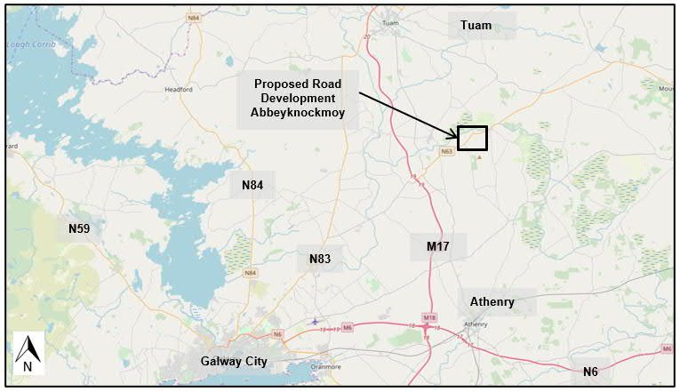
The Proposed Road Development is situated to the northeast of Galway City, located along the existing N63
corridor. The N63 is a national secondary route, and this section of the N63 is located directly to the east of
Abbeyknockmoy village. The Proposed Road Development is a 2.3 km road realignment which extends from the
eastern edge of Abbeyknockmoy, across the Abbert River, to the townland of Derreen and on towards the junction
of the N63 with the L6234. Figure 1-1 highlights the approximate location of the Proposed Road Development.
Figure 1-1 Regional Location of Proposed Road Development
The Environmental Impact Assessment Screening Report for the Proposed Road Development concluded that the
Proposed Road Development did not trigger the mandatory criteria for a road development under Section 50 of the
Roads Act 1993 (as amended) and Article 8 of the Roads Regulations, 1994 (as amended).
However, it was identified that under Section 50(1)(d) of the Roads Act 1993 (as amended), there would be potential
for significant effects on water quality and biodiversity as the Proposed Road Development will traverse the Abbert
River, (part of the Lough Corrib, Special Area of Conservation). A sub-threshold assessment was carried out as
part of a report to inform the Environmental Impact Assessment Screening Determination and concluded that the
Proposed Road Development has the potential to result in significant effects on sensitive biodiversity, landscape,
and cultural heritage receptors and therefore should be subject to preparation of an Environmental Impact
Assessment Report to accompany the planning application. Galway County Council in turn determined an
Environmental Impact Assessment was required under Section 50 of the Roads Act 1993 (as amended).
Under Section 50 of the Roads Act 1993 (as amended), Galway County Council submitted the Environmental
Impact Assessment Screening Report to An Board Pleanála for their consideration and in order to seek a direction
on Galway County Council’s determination prior to making this planning application. An Board Pleanála made the
determination that an EIAR was required for the Proposed Road Development (An Bord Pleanála -309050-20).
This Environmental Impact Assessment Report has been prepared in full accordance and compliance with the
provisions of Directive 2014/52/EU (Environmental Impact Assessment Directive), as well as the Roads Act 1993
(as amended) and the Roads Regulations 1994 (as amended). The preparation of the Environmental Impact
Assessment Report was undertaken in accordance with the requirements as set out in the Environmental Impact
Assessment Directive and relevant guidelines and documentation.
Prepared for: Galway County Council AECOM-ROD
Page NTS-1N63 Liss to Abbey Realignment Scheme Project number: 60597858 - GC/16/13416
Volume 1 Non Technical Summary
2 Need for the Proposed Road Development
The Need for the Proposed Road Development chapter outlines the requirement for the Proposed Road
Development based on the planning policy, the deficiencies in the existing road network, project objectives, and
identified future needs of the study area.
Overall, the need for the Proposed Road Development revolves around the requirement to provide a safe, robust
and resilient National Secondary road network, allowing the more efficient movement of people and goods at a
regional and local level, and the provision of improved facilities to encourage and promote active travel modal share
at a local community level.
The Proposed Road Development is a multi-modal transport scheme, with a provision for both cyclists and
pedestrians which will improve journeys across the Abbert River, with improved horizontal and vertical alignments.
These improved cross-sections, realignment and upgraded junctions will improve safety, particularly for pedestrians
and cyclists.
The specific needs for the Proposed Road Development include the following key issues:
Resolving Existing Safety & Alignment Issues on the National Road Network;
Providing Improved Regional Connectivity;
Providing Improved Local Connectivity at a Community Level;
Enabling Modal Shift to Active Travel Modes at a Community Level;
Existing Road Conditions;
Existing Traffic Issues; and
Existing Road Safety Issues.
The overall ambition of the Proposed Road Development is to achieve a number of specific objectives under a
number of multi criteria categories. The overarching headings for each of the objectives have been structured
around the headings required by the Transport Infrastructure Ireland (TII) Project Appraisal Guidelines:
Economy;
Safety;
Environment;
Accessibility and Social inclusion;
Integration; and
Physical Activity.
Each of the objectives are linked to the European, national, regional and local policies.
This chapter also includes a policy section which sets out the overarching planning framework, by examining
planning strategy, policy and guidance at European, national, regional and local levels. The review of strategic,
statutory and non-statutory plans demonstrates support and consistency with policy framework in regard to the
Proposed Road Development.
The principles of the Proposed Road Development will particularly assist with;
Supporting the objectives of the TEN-T in broad terms by improving the connection to Junction 19 on the M17
TEN-T network;
Enhancing regional and local accessibility, by providing improved accessibility and social inclusion to
community facilities and to heritage resources;
Maintain the strategic capacity and safety of the national roads network including planning for future capacity
enhancements;
Sustaining the economic growth through the provision of improved transport connectivity in this rural location;
Enhancing environmental benefits, through a reduction in traffic queuing and journey time reliability;
Prepared for: Galway County Council AECOM-ROD
Page NTS-2N63 Liss to Abbey Realignment Scheme Project number: 60597858 - GC/16/13416
Volume 1 Non Technical Summary
Improved safety through improved road alignment, pedestrian and cycle user segregation, and ultimately
reducing collisions in line with the Road Safety Strategy;
Ensuring adequate transport infrastructure is in place to meet demands from continued population growth;
and
Protecting and safeguarding investment made in strategic transportation infrastructure.
The Proposed Road Development is compliant with planning policies at a European, national, regional and local
level.
Prepared for: Galway County Council AECOM-ROD
Page NTS-3N63 Liss to Abbey Realignment Scheme Project number: 60597858 - GC/16/13416
Volume 1 Non Technical Summary
3 Consideration of Alternatives
The Consideration of Alternatives chapter considers reasonable alternatives which are relevant to the key project
decisions in the context of environmental impact. EIA guidance and legislation requires that consideration of these
alternatives should include, where relevant; design, location, routes, alignments/layouts, processes, technology,
size, and scale.
The alternatives considered are grouped as follows:
'Do-Nothing' Alternative;
'Do-Minimum' Alternative;
Alternative Modes;
Strategic Alternatives - Route Alignment Options; and
Design Development Alternatives (alternative locations and alternative layouts).
It is noted that a full Options Selection process was undertaken for this Proposed Road Development as part of the
earlier phases of the project and this document is included as an Appendix to this Environmental Impact
Assessment Report (Volume 04; Appendix A3-1). This was a phased assessment, in accordance with the Transport
Infrastructure Ireland Project Management Guidelines, which included the environmental assessment of options.
‘Do-Nothing’, ‘Do-Minimum’ and ‘Do-Nothing/Do-Minimum’ Alternatives
Do-Nothing Alternative
The ‘Do-Nothing’ consideration examined the potential of the existing road structure to meet future traffic and safety
demands without any upgrades. This scenario would not include any additional crossing of the Abbert River or
improvement of the existing road network other than routine maintenance.
Assessment of the ‘Do-Nothing’ alternative concluded that it would not meet the project’s objectives in terms of
safety and reducing traffic congestion. From an environmental perspective there would be limited opportunity to
improve safety for motorised and non-motorised users, there would be potential for increases in noise levels
resulting from traffic congestion with little scope for mitigation measures, and the existing drainage infrastructure
does not have any environmental protection measures in terms of surface water attenuation and hydrocarbon
interceptors which would be included in any new works.
Do-Minimum Alternative
The ‘Do-Minimum’ alternative investigated the potential to upgrade, rather than replace, the existing infrastructure
to meet the predicted traffic and non-motorised user demands for the next 30 years. The ‘Do-Minimum’ alternative
would not include any significant interventions other than local minor improvements within the road boundary
without consideration of any additional land take.
Issues identified related to the Do-Minimum alternative included a lack of additional crossings of the Abbert River,
the narrow cross-section of the carriageway and poor alignment of the existing N63. From an environmental
perspective there would be limited opportunity to improve safety, there would be potential for increases in noise
levels resulting from traffic congestion with little scope for mitigation measures, and the existing drainage
infrastructure does not have any environmental protection measures in terms of surface water attenuation and
hydrocarbon interceptors which would be included in any new works.
Do-Nothing/Do-Minimum Alternative
Due to the minor works involved in the ‘Do-Minimum’ alternative, the two were combined into the ‘Do-Nothing/Do-
Minimum alternative. However the ‘Do-Nothing/Do-Minimum’ alternative failed to address two issues which are
predominantly causing the current safety concerns.
The ‘Do-Nothing/Do-Minimum’ would not improve river crossing options as there would be no new crossing
points, due to the minimal works considered under this option.
Journey times would be increased and there would be no additional capacity for traffic travelling through the
area. The regional traffic and local traffic are not segregated, which results in little prospect of minimising
conflict and improving road safety.
Prepared for: Galway County Council AECOM-ROD
Page NTS-4N63 Liss to Abbey Realignment Scheme Project number: 60597858 - GC/16/13416
Volume 1 Non Technical Summary
In addition, there would be potential for increases in noise levels resulting from traffic congestion with little scope
for mitigation measures, and the existing drainage infrastructure does not have any environmental protection
measures in terms of surface water attenuation and hydrocarbon interceptors.
Ultimately it was determined that the ‘Do-Nothing/Do-Minimum’ alternative would not meet the objectives of the
scheme.
Alternative Modes
At present there are no dedicated cycle facilities within the area. There is currently a minor network of footpaths
and pedestrian facilities in the vicinity of the community facilities only and within parts of Abbeyknockmoy village,
however there are no connecting facilities. The Proposed Road Development will facilitate active travel modes
however dedicated pedestrian/cycle facilities alone would not address the project objectives.
There are no railways within the study area. As there are no railways within the study area it was not possible to
consider rail as an alternative mode of transport. Several regional bus routes pass through the study area, however,
improvements to the bus network or bus facilities would not meet the objectives for the Proposed Road
Development.
While alternative modes were considered not to meet the scheme objectives in isolation, it is noted that key Active
Travel facilities have been incorporated into the scheme as they support elements of the scheme objectives.
Strategic Alternatives
Six primary Route Options A-F were identified as part of a Stage 1 Route Option Assessment process. These Route
Options were identified taking into account engineering, economic and environmental considerations and having
regard to the issues and constraints identified in the Constraints Study.
All bridge options for the offline routes included a clear spanned crossing of the Abbert River and Special Area of
Conservation boundary and a connection to the L3110. The introduction of pedestrian/cyclist facilities was reviewed
as part of the route options strategy.
During Stage 2 ‘Project Appraisal of Route Options’ the three highest ranking route options (A, B and C) were
progressed along with the ‘Do-Nothing/Do-Minimum’ alternative. There were no major changes between the Stage
1 route options and those brought forward to Stage 2. Where possible, route options were amended locally and in
consultation with environmental specialists to minimise impacts, while respecting the study area constraints. All the
route options included one new crossing of the Abbert River and an at-grade junction with the L3110.
All three route options required the acquisition of greenfield lands and would likely result in the loss of treelines and
hedgerows between agricultural fields. The provision for a bridge over Abbert River, which forms part of Lough
Corrib Special Area of Conservation, could cause potential impacts during the construction and operational phases.
During construction this would include at the construction site and downstream related to instream works or works
in close proximity to the Special Area of Conservation.
Following assessment using the six Common Appraisal Framework criteria (Economy, Safety, Environment,
Integration, Accessibility & Social Inclusion, and Physical Activity) the Emerging Preferred Route (Route Option B)
was then taken forward to the preliminary design stage.
Design Development and Alternatives
Amendments made throughout the preliminary design process included development of accommodation works via
consultation with directly impacted landowners, refinement of local junctions, access arrangements in order to
improve accessibility and performance and horizontal alignment alterations were undertaken to minimise impact
on property owners. Various alignment options were investigated with the aim to minimise impacts on residential
properties and revisions were made to the alignment where practicable.
Following the identification of a preferred route option, a review was carried out to identify and detail preferred
junction options, along with the proposed layout of the pedestrian and cycle facilities routes. Five junction areas
were identified along the Proposed Road Development and a number of junction options were considered for each
area. Following an assessment of junction options a preferred junction option for each area was chosen. During
this process it was deemed that a connection along the existing downgraded N63 between the residential area and
the community facilities would be more beneficial than including the pedestrian and cycle facilities along the new
section of road, as this would facilitate connection between the residential area and the community facilities of
Abbeyknockmoy.
Prepared for: Galway County Council AECOM-ROD
Page NTS-5N63 Liss to Abbey Realignment Scheme Project number: 60597858 - GC/16/13416
Volume 1 Non Technical Summary
A Structural Options Report was also developed to investigate the various bridge options. There were three bridge
options, and they all assumed a Type 2 Single Carriageway as the minimum desirable cross-section at the bridge
crossing location. The minimum bridge cross-section will be 14 m wide.
The potential environmental impacts of the bridge construction were considered as part of project planning. The
magnitude of the environmental effects was related to a number of factors such as the location, quantity and choice
of materials, span and structural form. Of the three options, Option 2 Steel Girder was the most favourable when
compared to the alternatives and was carried forward to the Preliminary Bridge Design.
Description of the Proposed Road Development
Beginning at Abbeyknockmoy village, the Proposed Road Development will deviate offline to the north of the
existing N63 and be connected to the existing road network through a three-armed roundabout. From there, it will
continue in a north-easterly direction through agricultural land before crossing the Abbert River at a skewed angle
of approximately thirty-five degrees. The proposed alignment will then sweep east and continue through more
agricultural land, running parallel to the existing N63. The alignment then crosses the L6159 and continues east
through an area of existing woodland until it ties in with the existing N63 at its junction with the L6234. The existing
L6159 will be realigned to create a north/south staggered junction with the proposed alignment, and the L6234 will
be realigned to tie in with the proposed alignment.
The introduction of dedicated pedestrian and cyclist facilities along the existing downgraded section of the N63 will
be included as part of this Proposed Road Development to connect the residential area of the village to the
community facilities.
Prepared for: Galway County Council AECOM-ROD
Page NTS-6N63 Liss to Abbey Realignment Scheme Project number: 60597858 - GC/16/13416
Volume 1 Non Technical Summary
4 Description of the Proposed Road Development
This chapter provides a description of the Proposed Road Development, the design of which advanced from the
Emerging Preferred Route identified during the route options selection process. Surveys, assessments and
information that form the basis of this Environmental Impact Assessment Report are based on the design of the
project as described in this chapter.
The refinement of the Proposed Road Development took cognisance of a number of constraints, such as the Abbert
River, Lough Corrib Special Area of Conservation, and Knockmoy Abbey (National Monument No.166). Avoidance
mitigation measures have been included in the design to reduce the direct and indirect impact on sensitive
environmental receptors. These avoidance mitigation measures include;
A clear span steel girder bridge to minimise visual impact on Knockmoy Abbey and flood culverts to minimise
impact on the Abbert River (which forms part of Lough Corrib Special Ares of Conservation);
A closed drainage network to minimise the impact on the Special Area of Conservation and surrounding
watercourses;
The Preferred Route was chosen to minimise impact on the National Primary School;
Regrading earthworks and introducing planting to minimise the impact for vehicle restraints and anti-dazzle
screening.
Updating the horizontal geometry to reduce impact on landowners; and
Minimising impacts in the vicinity of Knockmoy Abbey.
Summary of the Proposed Road Development
The Proposed Road Development is located in the townlands of Culliagh North, Culliagh South, Liss, Abbey,
Chapelfield, Clashard, Moyne and Newtown in Co. Galway and runs in a south-west to north-east direction across
the Abbert River. Starting on the eastern edge of Abbeyknockmoy and running north-east to the proposed tie-in
with the existing N63 at the L6234 junction.
The Proposed Road Development will comprise a rural all-purpose Type 2 Single Carriageway road, including a
new crossing over the Abbert River. Provision of both pedestrian and cycle facilities have been included
predominantly along the route of the existing N63 to connect the residential area of Abbeyknockmoy village to the
community facilities.
Beginning at Abbeyknockmoy village, the Proposed Road Development will deviate offline to the north of the
existing N63 and be connected to the existing road network through a three-armed roundabout. From there, it will
continue in a north-easterly direction through agricultural land before crossing the Abbert River at a skewed angle
of approximately thirty-five degrees. The proposed alignment will then sweep east and continue through more
agricultural land, running parallel to the existing N63. The alignment then crosses the L6159 and continues east
through an area of existing woodland until it ties in with the existing N63 at its junction with the L6234. The existing
L6159 will be realigned to create a north/south staggered junction with the proposed alignment, and the L6234 will
be realigned to tie in with the proposed alignment.
The Proposed Road Development will comprise the following major elements:
Approximately 2.3 km of new Type 2 Single Carriageway road (predominantly offline);
One new roundabout at the western end of the Proposed Road Development to provide connection with the
existing N63;
Two new priority junctions to provide connection to the existing L6159 and L6234, including some minor local
road realignments;
One new clear span steel girder bridge crossing of the Abbert River;
A number of new piped culverts and two new box culverts over existing field ditches;
Three new flood alleviation culverts;
New pedestrian and cycle facilities, predominantly located along the existing N63;
Associated earthworks including excavation of unacceptable material, excavation and processing of rock and
other material, and recovery of unacceptable material for re-use in the works;
Prepared for: Galway County Council AECOM-ROD
Page NTS-7N63 Liss to Abbey Realignment Scheme Project number: 60597858 - GC/16/13416
Volume 1 Non Technical Summary
Accommodation works, including the provision of access roads and accesses;
Drainage works, including the construction of attenuation ponds in accordance with sustainable drainage
design principles and guidance;
Treatment of surface water run-off prior to outfall discharge, spill containment measures and attenuation
treatment facilities;
Utilities and services diversion works including medium voltage (10 kV/20 kV) overhead lines and EIR
overheard and underground lines;
Safety barriers, public lighting, fencing;
Viewing area for Knockmoy Abbey with parking;
Landscaping planting works, signage, lighting and other works ancillary to the construction and operation of
the Proposed Road Development;
Construction of farm access tracks with accommodation works ancillary to the Proposed Road Development;
and
Environmental measures and other ancillary works.
The location and extent of the Proposed Road Development are shown in Figure A4-1 to Figure A4-6 contained in
Volume 03 of this EIAR.
Mainline Alignment and Side Roads
The mainline alignment will compose two unique individual sections, running from the south-west to north-east for
a total length of 2.30 km:
Section A: Ch. 0+070 to 0+250 – From the western tie-in along the existing N63 in the village of
Abbeyknockmoy to the proposed roundabout. This section of the mainline alignment was developed to
achieve a design speed of 60 km/h, consistent with the posted speed limit of 50 km/h within the village of
Abbeyknockmoy.
Section B: Ch. 1+000 to 3+120 – From the proposed roundabout to the eastern tie-in along the existing N63
east of the junction with the L6234. This section of the mainline alignment was developed to achieve a design
speed of 100 km/h, consistent with the posted speed limit of 100 km/h for Type 2 Single Carriageway National
Roads.
It is proposed that the side roads will be reconfigured to tie-in with existing or realigned roads, where necessary.
Where side roads have been realigned, they have been designed to tie-in to the existing carriageway as quickly as
possible to minimise the impact of the Proposed Road Development on the surrounding environment.
For the local roads, the design speeds are suitable to the existing low-speed character of these roads and will
assist to minimise any impact on the environment at those locations. Where side roads have existing speed
restrictions, proposed speed restrictions, or are in more built-up areas, the appropriate design speed has been
established in accordance with Sections 1.1 and 10.2 of DN-GEO-03031(TII, 2017) and DMURS (2019).
Drainage – General Principles
The proposed drainage design incorporates:
Systems for the collection and conveyance of overland water and surface water run-off;
Measures to treat and attenuate the surface water run-off from the new paved surfaces of the Proposed Road
Development; and
Treatment of existing watercourses crossed or affected by the Proposed Road Development.
Prepared for: Galway County Council AECOM-ROD
Page NTS-8N63 Liss to Abbey Realignment Scheme Project number: 60597858 - GC/16/13416
Volume 1 Non Technical Summary
The preliminary design of road drainage for the Proposed Road Development is in accordance with the principles
outlined below and the following TII Publications:
DN-DNG-03022 - Drainage Systems for National Roads (including Amendment No. 1 dated June 2015) (TII,
2015);
DN-DNG-03064 – Drainage of Runoff from Natural Catchments (including Amendment No. 1 dated June
2015) (TII, 2015);
DN-DNG-03065 - Road Drainage and the Water Environment (including Amendment No. 1 dated June 2015)
(TII, 2015); and
DN-DNG-03066 - Design of Earthworks Drainage, Network Drainage, Attenuation & Pollution Control.(TII,
2015).
Prepared for: Galway County Council AECOM-ROD
Page NTS-9N63 Liss to Abbey Realignment Scheme Project number: 60597858 - GC/16/13416
Volume 1 Non Technical Summary
5 Traffic Analysis
The Traffic Analysis chapter assesses the impacts of the Proposed Road Development on traffic. It defines the
traffic assessment study area; the methodology used for developing the baseline and impact assessment; provides
a description of the baseline environment in relation to traffic, active travel model and safety. It presents the findings
of the impact assessment at construction phase and operational phase, and the proposed mitigation and monitoring
measures.
Traffic modelling tools were used to analyse the N63 Liss to Abbey Realignment Scheme (the Proposed Road
Development) and the future year traffic growth factors used to generate projected Annual Average Daily Traffic
(AADT) on all key roads in the study area. Existing and projected traffic figures are presented for both the Do-
Minimum and Do-Something scenarios. These figures provide a basis for the engineering design presented in
Chapter 04 (Description of the Proposed Road Development) and the assessments presented in Chapter 10 (Air
Quality), Chapter 11 (Noise and Vibration) and Chapter 16 (Climate). The overall commentary on the predicted
changes in traffic conditions provides a setting for a number of the other assessments undertaken in this
Environmental Impact Assessment Report.
During the construction phase, the resulting percentage increase in Annual Average Daily Traffic flows as a result
of the construction traffic generated by the Proposed Road Development were established. The daily percentage
impacts on the existing N63 will be +2.4% and +3.3% to the west and east of the Proposed Road Development
respectively. It is noted that these impacts are based on the worst-case assessment where the entirety of
construction traffic will travel from/to the Proposed Road Development from east or from west, while a more realistic
scenario would be a combination of the two.
With implementation of the mitigation measures identified, there will be no major effects during the construction
phase of the Proposed Road Development.
During the operational phase, the results for the both the Opening Year (2023) and Design Year (2038) show that
implementation of the Proposed Road Development will cause a substantial decrease in Annual Average Daily
Traffic flows on the following section:
Existing N63 between the proposed roundabout and the L7138;
Existing N63 between the L7138 and L3110 (at the Newtown National School and Abbeyknockmoy
Community Centre); and
Existing N63 between L3110 and L6159 (across the existing Liss Bridge).
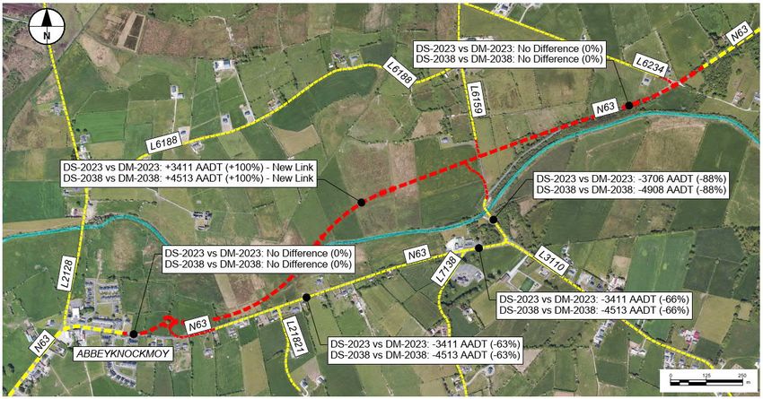
Figure 5-1 illustrates the relative differences in traffic volumes between the Do-Minimum and Do-Something
scenarios for the assumed Opening Year (2023) and Design Year (2038); where the positive figures indicate
increased traffic volumes as a consequence of the Proposed Road Development implementation and negative
figures indicate reduced traffic volumes as a consequence of the Proposed Road Development implementation.
Prepared for: Galway County Council AECOM-ROD
Page NTS-10N63 Liss to Abbey Realignment Scheme Project number: 60597858 - GC/16/13416
Volume 1 Non Technical Summary
Figure 5-1 AADT Difference between Proposed Road Development (Do-Something) and Do-Minimum
The Proposed Road Development will see localised changes to the local and national road network and traffic
flows. The modelling work undertaken to assess the traffic impacts of the Proposed Road Development indicates
that there will be an overall positive traffic benefit associated with the Proposed Road Development. Further, the
Proposed Road Development will provide benefits to pedestrian and cycling facilities on the adjoining local road
network. Therefore, there are no residual negative traffic effects anticipated.
Overall, the Proposed Road Development (Do-Something) will provide benefits for the entire network compared to
the Do-Minimum option. The network statistics illustrate that the Proposed Road Development will provide a
reduction in total distance travelled (-4.4%), a reduction in travel time (-20.4%) and an increase in average speed
(+20.1%) throughout the entire modelled road network.
The Proposed Road Development will be of a higher safety standard than the existing road network and will
therefore contribute to a network-wide reduction in collisions. This is reflected in the forecasted reduction of 15
collisions over the 30-year design life appraisal period. This equates to a reduction of 27 casualties (1 Fatal, 2
Serious, and 24 Slight).
The Proposed Road Development will provide a dedicated walking and cycling facility on the south side of the
existing road, connecting the village with community facilities. New pedestrian and cycle crossings will be provided
at the school and at the junction of the N63 and local road L3110. The new facility and the removal of regional
traffic from the existing road will enable a significant increase in the use of active modes.
No likely significant negative traffic impacts are anticipated as a result of the Proposed Road Development. The
traffic analysis shows that the Proposed Road Development results in significant benefits in terms of network
performance and journey time savings. The network statistics show that the Proposed Road Development will lead
to a 20% reduction in the journey times on N63 routes along the section included within the study area.
The Proposed Road Development will result in reduced traffic levels and congestion in proximity of the
Abbeyknockmoy Community Centre and Newtown National School. The Proposed Road Development will alleviate
traffic along the existing N63 and will provide a better quality of life for the local community and provide a safer
environment for all users. By reducing the number of vehicular traffic on the existing N63 between the
Abbeyknockmoy village and the Community Centre, and through the provision of pedestrian and cycle facilities,
more sustainable travel will be supported and encouraged, facilitating a commute using active modes and the
public transport system.
Prepared for: Galway County Council AECOM-ROD
Page NTS-11N63 Liss to Abbey Realignment Scheme Project number: 60597858 - GC/16/13416
Volume 1 Non Technical Summary
Without the Proposed Road Development, traffic delays would continue along the existing N63 National Secondary
route, particularly at the Liss Bridge, and negative environmental impacts related to high traffic volumes in proximity
to the Newtown National School and Abbeyknockmoy Community Centre would continue. The traffic volumes
would have negative impacts for the local communities along the route in terms of safety, security, amenity, noise,
air quality, and particularly so in the case of vulnerable road users where there are no existing facilities. Road safety
on the N63 route particularly in proximity of the existing Liss Bridge will diminish due to growing traffic flows.
Likewise, the road safety rating on the N63 will worsen due to the increase in traffic volumes and Heavy Goods
Vehicle traffic.
Prepared for: Galway County Council AECOM-ROD
Page NTS-12N63 Liss to Abbey Realignment Scheme Project number: 60597858 - GC/16/13416
Volume 1 Non Technical Summary
6 Population and Human Health
The Population and Human Health chapter presents the likely significant effects on land use and accessibility,
employment and human health and well-being as a result of the Proposed Road Development.
During the construction phase of the Proposed Road Development, there is the potential for negative effects to be
experienced. Potential impacts include impacts on amenity at local residential properties and land acquisition. The
effect of the Proposed Road Development on air quality, noise, and neighbourhood amenity as a determinant of
human health is assessed to be negative during construction, due to the potential negative, moderate, and
significant noise effects on sensitive receptors in the study area. It is envisioned that the majority of effects
experienced will be restricted to a local scale and will be temporary and/or short term in nature.
The temporary acquisition of the land will likely result in a temporary, negative, and low effect on the existing
residential land and its users (medium sensitivity); therefore, the significance of effect will likely be not significant.
The permanent acquisition of the land will likely result in a permanent, negative, and negligible effect on the
existing land use and its users; therefore, the significance of the effects will likely be slight as a result of the land
take.
During the operational phase, the Proposed Road Development is expected to reduce network travel time, traffic
volumes, and associated congestion at Liss bridge, thereby improving accessibility to local services and
businesses.
The separation of regional and local traffic coupled with the introduction of pedestrian/cycling facilities will improve
accessibility to employment sites in Abbeyknockmoy and potentially create a more attractive, safer router for
vulnerable road users. The separation of regional and local traffic and the improvement of the quality of the existing
N63 will also improve accessibility to employment sites in the wider region.
The dedicated pedestrian/cycle routes will allow for direct active travel access from Abbeyknockmoy village to the
community facilities. The new routes will introduce safe access to the school, creche, GAA club and church in the
study area. In turn this will allow safe access for children but will also offer safe access for vulnerable road users
and give people a new connection to the community facilities.
During operation it is considered the Proposed Road Development will have a positive effect on with relation to
access to healthcare services and other social infrastructure, accessibility to work and training and active travel
options, and air quality, noise and neighbourhood amenity.
Prepared for: Galway County Council AECOM-ROD
Page NTS-13N63 Liss to Abbey Realignment Scheme Project number: 60597858 - GC/16/13416
Volume 1 Non Technical Summary
7 Biodiversity
An assessment was carried out of the likely significant effects of the Proposed Road Development on the
biodiversity interests of the receiving environment.
Survey Programme
A number of multidisciplinary ecology surveys were completed to inform the Biodiversity Chapter. The surveys were
carried out to map habitats and plant species (including invasive species) and also to identify bat, bird, and other
protected fauna species (such as badger and otter). The surveys also verified the results of desktop surveys
regarding the distribution of Qualifying Interest habitats of the Lough Corrib Special Area of Conservation.
Baseline Conditions
Designated Sites
The Proposed Road Development will cross the Abbert River. This river forms a part of the Lough Corrib Special
Area of Conservation. There is therefore a potential for direct impacts on this designated site. Habitats associated
with this designated site occur within the Proposed Road Development site.
Habitats
Habitats of high ecological value were recorded within and in the surrounding vicinity of the Proposed Road
Development. These included species-rich wet grassland (GS4) that correspond with the Annex I habitat ‘Molinia
meadows on calcareous, peaty or clay-laden soils. Calcareous springs (FP1) that correspond to the Annex I habitat
Petrifying Springs with Tufa Formations were also recorded. The Abbert River is an eroding river (FW1) which offers
excellent habitat for Annex II animal species. Non-native invasive alien plant species were also recorded in three
locations.
Fauna
Bats
A total of four species of bat were detected during field surveys; Common pipistrelle, soprano pipistrelle, Leisler’s
bat and Daubenton’s bat. Bat activity was principally concentrated along the river and riparian habitats and the
treelines and hedgerows at the eastern end of the Proposed Road Development. The Abbert river is important for
Daubenton’s bats and also other species that use the riparian corridor for commuting and foraging.
Badger
No active setts were recorded within the vicinity of the Proposed Road Development or the wider area during field
surveys. Much of the habitats present are considered unsuitable to support the development of setts. However,
evidence of a badger territory to the north-east of the Proposed Road Development was found. More suitable
habitat for badger setts and foraging/feeding occurs to the north, south and east of the Proposed Road
Development.
Otter
Evidence of otter activity was found at several locations along the Abbert River. The remains of an otter were also
found. It may be assumed that all of the river within the vicinity of the Proposed Road Development is within an
otter territory. This species is a Qualifying Interest of Lough Corrib Special Area of Conservation.
Other Protected Mammals
Irish hare was recorded on the site. Irish stoat, pygmy shrew, hedgehog, pine marten and red squirrel are also
considered to be present within the Proposed Road Development based on the presence of suitable habitats
present onsite.
Prepared for: Galway County Council AECOM-ROD
Page NTS-14N63 Liss to Abbey Realignment Scheme Project number: 60597858 - GC/16/13416
Volume 1 Non Technical Summary
Birds
Kingfisher, an Annex I species was recorded within the riparian area of the Abbert River and is likely breeding here.
Little Egret, another Annex I species was also recorded. Three birds of prey were recorded – Buzzard, Kestrel and
Sparrowhawk. No suitable breeding habitat for Barn Owl was found within the survey area. Using BoCCI
classification (Colhoun and Cummins, 2013), two Red-Listed breeding bird species – Meadow Pipit and Grey
Wagtail were recorded, and sixteen Amber-Listed breeding species were recorded in total. The majority of the bird
species recorded were Green-listed breeding species. Winter bird surveys carried out between 2019 and 2021
recorded Lapwing, a Red-List species, among other commoner species such as Snipe, Teal and Mallard.
Amphibians
While the only confirmed breeding site of the Common Frog was found at some remove from the Proposed Road
Development, based on the suitable nature of the habitats present onsite, this species is considered to be present
within the the Zone of Influence of the Proposed Road Development. No evidence of newts was found.
Fish
Atlantic Salmon, Sea Lamprey and Brook Lamprey are all Annex II species that are qualifying interests of the Lough
Corrib Special Area of Conservation of which the Abbert River is a part. A fisheries survey in 2019 recorded Salmon
and Brown Trout within the survey area of the Proposed Road Development. Brook Lamprey have previously been
recorded in the wider catchment and it is therefore considered to be present within the Zone of Influence of the
Proposed Road Development.
Common Lizard
Based on the habitats present this species is considered to be present within the Zone of Influence of the Proposed
Road Development.
Invertebrates
Some suitable habitat (wet grassland) for Marsh Fritillary (the only Annex II invertebrate) butterfly occurs within the
wider area. Devil’s Bit Scabious, the food-plant of this butterfly, was found within the footprint of the Proposed Road
Development. However, a survey for this species did not find any of its larval webs.
Other
While there is suitable habitat for White-Clawed Crayfish within the Abbert River, a targeted survey did not find any
evidence of this species. Other species were considered but were not considered to be present within the Zone of
Influence of Proposed Road Development. These include Freshwater Pearl Mussel and notable butterflies such as
Small Blue.
Potential Impacts
In the absence of mitigation, the Proposed Road Development could have a range of potential impacts on the
Qualifying Interests of a European site within the Zone of Influence and other protected habitats and species during
the construction and operation phase. Significant potential impacts include habitat loss, habitat deterioration,
disturbance (i.e. visual, vibration and noise, temporary barriers to connectivity, artificial lighting etc.), the potential
for the release of pollutants and contaminants to receiving watercourses and bird strike and mortalities.
Mitigation
The Proposed Road Development adopts a number of embedded control measures that avoid the potential for any
adverse impacts on the Qualifying Interest of the Lough Corrib Special Area of Conservation, nationally designated
and/or protected habitats and species and Annex I habitats.
Key additional mitigation measures during construction and operation include:
Monitoring during construction and operation by suitably experience ecologists;
Translocation of plant material and substrate from the Molinia grassland to a compensatory receptor site.
Production of an Ecological Monitoring Strategy;
Pre-construction surveys;
Prepared for: Galway County Council AECOM-ROD
Page NTS-15N63 Liss to Abbey Realignment Scheme Project number: 60597858 - GC/16/13416
Volume 1 Non Technical Summary
Pollution control;
Timing/phasing of clearance and earthworks;
Invasive Species Management Plan;
Construction Environmental Management Plan;
Artificial lighting plan; and
Species-specific mitigation for
─ Bats;
─ Badger;
─ Otter;
─ Amphibian;
─ Breeding birds; and
─ Protected mammals (other than those above).
Residual Impacts
The Proposed Road Development will result in the loss of a portion of grassland that corresponds with an Annex I
habitat type. Following translocation of turves/plant material and habitat recreation works, mitigation will be
achieved by replacement with compensatory habitat which will be suitably managed by the local authority. The
significance of the residual impact is assessed as a negative effect at the local-county geographic scale. All
other residual effects will be limited to significance at Local level.
Significant residual effects during operation to other species and habitats are predicted to be limited to Local level
in all cases, namely in relation to disturbance during operation to localised populations of nationally protected
species including nesting birds, hedgehog, pygmy shrew, stoat, and common frog.
Following implementation of mitigation measures, residual effects to the Special Area of Conservation will be non-
significant during the construction phase. There will be no significant residual effects on designated sites during
operation.
Prepared for: Galway County Council AECOM-ROD
Page NTS-16N63 Liss to Abbey Realignment Scheme Project number: 60597858 - GC/16/13416
Volume 1 Non Technical Summary
8 Land and Soils
The Land and Soils chapter presents an assessment of the impacts of the Proposed Road Development on land,
soils, geology and hydrogeology (groundwater). It defines the study area, the methodology used for developing the
baseline and impact assessment. It also provides a description of the baseline environment in relation to land and
soils and presents the findings of the impact assessment.
The chapter should be read in conjunction with Chapter 16 Material Assets Non-agriculture and Chapter 17 Material
Assets Agriculture. Both of these chapters include an assessment of impacts from land take.
The methodology used for describing the potential effects considers the “quality” of the effects (i.e. whether it is
adverse or beneficial), the “probability” of the event occurring and the “duration” of the effects (i.e. whether it is
short or long term) as per Table 3.3 of the Environmental Protection Agency’s ‘Guidelines on the information to be
contained in Environmental Assessment Reports’. Specific assessment criteria and typical examples based on
information within the Transport Infrastructure Irelands’ ‘Guidelines on Procedures for Assessment and Treatment
of Geology, Hydrology and Hydrogeology for National Road Schemes’.
Information relating to regional, local and site conditions was assessed using publicly available datasets and
geotechnical site investigation carried out at the Proposed Road Development site. The general ground profile at
the site consists of topsoil over alluvium and till deposits, beneath which is limestone bedrock.
The potential impacts to the soils, geology and hydrogeology from the Proposed Development were assessed.
Potential impacts assessed included impacts to soil and groundwater quality from accidental spills and leaks,
excavation and stockpiling of soils, removal of hardstanding, pumping of groundwater, use of concrete and lime
and depletion of non-renewable natural resources. A number of mitigation measures were identified and will be
implemented so that there will be no significant adverse effects to the soils, geological and hydrogeological
environment during the construction and operation of the Proposed Road Development. The cumulative impacts
of the Proposed Road Development on soil, geology and hydrogeology were considered and it was concluded
cumulative effects will be imperceptible.
It is considered that significance of residual effects of the Proposed Road Development on soil, geology and
hydrogeology during both the construction and operational phase will overall be imperceptible provided that
appropriate mitigation measures are applied.
Prepared for: Galway County Council AECOM-ROD
Page NTS-17N63 Liss to Abbey Realignment Scheme Project number: 60597858 - GC/16/13416
Volume 1 Non Technical Summary
9 Water
The Water chapter examined how the construction and operation of the Proposed Road Development will interact
with the water environment and assessed potential impacts to the water environment from the Proposed Road
Development. Existing published water data and other information regarding natural surface waters were reviewed
as part of the chapter compilation. A Flood Risk Assessment was prepared for the Proposed Road Development
site.
During construction, potential impacts include sedimentation, accidental spills and leaks, use of concrete and lime,
bridge construction, culverting and drainage works. A number of mitigation measures will be implemented to reduce
the likelihood of significant adverse effects to the water environment during the construction of the Proposed Road
Development.
During operation potential impacts include accidental spills and leaks, discharges to surface water, flooding
resulting from the Proposed Road Development and impacts of flooding on the Proposed Road Development.
A number of embedded mitigation measures will reduce the likelihood of significant adverse effects to the surface
water environment during the operation of the Proposed Road Development. Surface water collected on the
Proposed Road Development site will utilise a closed drainage system and will be discharged via ponds to the
Abbert River. Surface water will be discharged at greenfield runoff rates. In order to achieve this, flow control
restricting devices such as a vortex flow control device will be installed upstream of the outlet to a receiving
waterbody.
In terms of cumulative impacts, the impact of the Proposed Road Development has been considered in relation to
a number of proposed and consented developments adjacent to the Proposed Road Development site. However,
due to the proposed mitigation measures, the cumulative effects from both construction and operation are not
considered likely.
Taking into account the construction impacts, it is considered that the residual effect from the Proposed Road
Development will be imperceptible provided that appropriate mitigation measures as specified are applied.
The embedded mitigation measures outlined in Chapter 04 Description of the Proposed Road Development will
reduce the likelihood and magnitude of the potential effects on the water environment occurring during the
operational phase. The significance of effects during the operational stage has been assessed as moderate/slight,
based on the modelled increase in flood levels associated with the proposed river crossing.
Prepared for: Galway County Council AECOM-ROD
Page NTS-18N63 Liss to Abbey Realignment Scheme Project number: 60597858 - GC/16/13416
Volume 1 Non Technical Summary
10 Air Quality
The Proposed Road Development has been assessed for the impacts it will have on air quality in the local area
and regionally. The impacts during the construction period, and during the operation of the Proposed Road
Development have been considered.
The air quality assessment has been carried out based on Transport Infrastructure Ireland’s ‘Guidelines for the
Treatment of Air Quality during Planning and Construction of National Roads’. Where necessary new publications
since its publication, particularly Highways England ‘LA105 Air Quality’ (2019), and Environmental Protection
UK/Institute of Air Quality Management ‘Land-Use Planning & Development Control: Planning For Air Quality’
(2017) have also been taken into account.
The assessment considers the pollutants nitrogen dioxide (NO2), and particulate matter (PM10 and PM2.5). These
are the two main air pollutants of concern which come from the exhaust gas of vehicles, among other sources.
Because of the health effects of NO2 and PM, there are legal limits in place on these pollutants. These limits apply
at places like homes, hospitals, and schools.
As described in the TII Guidance document, the following seven elements were considered for the air quality
assessment.
Baseline air quality conditions (qualitative);
Construction dust assessment (qualitative);
Construction traffic (HGVs) assessment (qualitative);
Calculation of the Index of Overall Change of Exposure for the Proposed Road Development (quantitative);
Determination of the pollutant concentration (NO2, PM10 and PM2.5) at worst case sensitive receptors
(quantitative);
Consideration of impacts on sensitive ecosystems (quantitative); and
Calculation of regional emissions (NO2, PM10 and CO2) associated with the Proposed Road Development.
The study area lies within the air quality Zone D. NO2 and PM concentrations in this zone are generally low, and in
2019, the legal limits on concentrations of NO2, PM10, and PM2.5 were not breached anywhere in this Zone.
Background concentrations representative of the study area are very low, well below the applicable legal limits.
During the construction phase by using standard industry good practice mitigation measures as outlined in the
Construction Environmental Management Plan, the dust effect will be not significant. Similarly, the number of
Heavy Goods Vehicles used is expected to be small enough that the effect of the construction traffic will also be
not significant.
The Index of Overall Change of Exposure calculations concludes that there will be an overall reduction in exposure
to NOX and PM10 as a result of the operation of the Proposed Road Development. This is because the majority of
sensitive receptors in the study area (e.g. residential properties) are located along the existing N63, and
approximately 60% of vehicles will use the Proposed Road Development instead, which is further away from these
receptors. The same theme is shown in the local air quality assessment, where pollutant concentrations decrease
at locations close to the existing N63. However, at some locations closer to the Proposed Road Development,
pollutant concentrations will increase, though, the absolute levels are still very low, well within the legal limits.
Therefore, the effects will be negligible and not significant.
There is one designated ecological site that is within the study area, Lough Corrib Special Area of Conservation.
The impacts on this site vary as at some locations within the site, traffic increases (e.g. the Proposed Road
Development) and at other locations it decreases (e.g. the existing N63). At all locations, the concentration of NOX
is well below the legal limits for designated sites. The effects at this ecological site will be negligible and not
significant.
Prepared for: Galway County Council AECOM-ROD
Page NTS-19You can also read