NATIONAL REPORT - Tunisian Navy Hydrographic and Oceanographic Center - 22th Meeting of the Mediterranean and Black Seas
←
→
Page content transcription
If your browser does not render page correctly, please read the page content below
Tunisian Navy Hydrographic and Oceanographic Center

                 NATIONAL REPORT

    22th Meeting of the Mediterranean and Black Seas
         Hydrographic Commission (MBSHC-22)

                    27 – 28 May 2021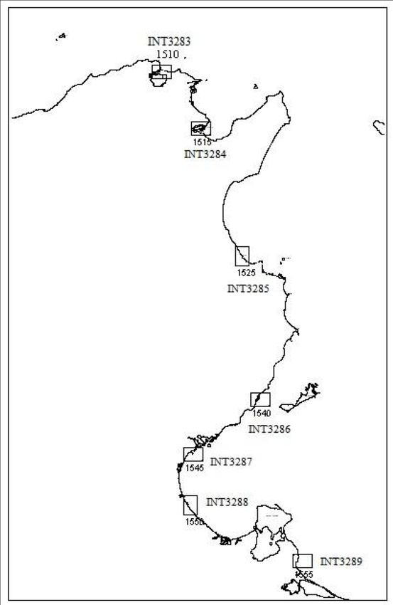
1. Hydrographic Office / The Tunisian Navy Hydrographic and Oceanographic Center (TNHOC) is the
Service: national authority with regards to nautical chart production.
The TNHOC collects, processes and distributes information related to safety
of navigation. In the same time, the center analyses, archives, and implements
databases in this field.
The TNHOC also provides hydrographic and oceanographic services to third
parties.
2. Surveys:
During the period between 2019 and 2021, the TNHOC has conducted many
Coverage of new hydrographic surveys mainly concentrated in the east coast of Tunisia. These
surveys hydrographic surveys were used to update the INT3210 and TN7520 charts
(See annex 1) and to produce new chart INT3212 (in progress).
Between 2019 and 2021, the TNHOC had purchased the following
hydrographic equipment:
Four tides stations with meteorological sensors;
New technologies and Two sound velocity profilers (Valeport miniSVP);
/or equipment: Two meteorological sensors;
Two miniSVS sound velocity sensors (Valeport);
The TNHOC has recently purchased a new multibeam system
KONGSBERG M3 PHS sonar for shallow water and coastal surveys.
New ships: N.A.
Problems encountered: N.T.R
3. New charts & updates:
The status of Tunisian ENCs production is:
Name Edition Issue date Scale Nav. purpose
TN313208 2 08.01.2021 1/180000 Coastal
TN313210 2 08.01.2021 1/180000 Coastal
TN317500 2 15.09.2020 1/90000 Approach
TN317505 1 13.03.2019 1/90000 Approach
TN317510 1 15.02.2020 1/90000 Approach
ENCs: TN317515 1 15.05.2020 1/90000 Approach
(See ENCs coverage in TN317520 1 15.09.2020 1/90000 Approach
annex 2) TN412500 1 15.09.2020 1/22000 Approach
TN412510 3 15.12.2018 1/22000 Approach
TN412520 3 15.06.2020 1/22000 Approach
TN415000 2 31.01.2019 1/45000 Approach
TN511500 1 31.07.2020 1/12000 Harbour
TN511505 4 30.09.2018 1/12000 Harbour
TN511510 4 23.05.2017 1/12000 Harbour
TN511515 3 15.06.2020 1/12000 Harbour
ENC Distribution method: All Tunisian ENCs are distributed through IC-ENC.
RNCs: N.A.
INT Charts: (See annex 3)
Published: The coproduced charts INT3208 and INT3210 with respectively Algerian
hydrographic service and Italian hydrographic institute are published.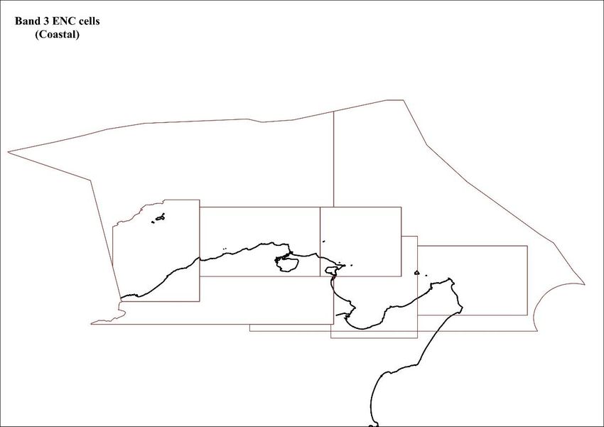
In progress: INT 3212 with the Italian Hydrographic Institute.
"Da Ras El-Mir à Cap Africa – Pantelleria e Isole Pelagie"
Scale : 1/250 000
Planned: N.A
The TNHOC has produced 15 nautical paper charts covering the northern part
of Tunisia. The online catalogue of national paper charts is available through
the following link:
http://www.cnct.defense.tn/index.php/fr/produits-et
services/produits/item/183-cartes
The status of nautical paper charts produced by the TNHOC is mentioned in
the table here below:
Title Scale
150 : De Ras Engela à Ras Mostfa. 1/150000
7500 : De cap Roux à cap Serrat
7505 : De cap Serrat à cap Zebib
7510 : De cap blanc à Jaziret El Monbasta (De Cap Blanc à
l’ile Plane) 1/75000
7515 : De Jaziret Pilau à Jaziret Zembra (De l’ile Pilau à l’ile
de Zembra)
7520: De Jaziret Zembra à K'libia
5000 : De cap Gamarth à Ras Fartass 1/50000
National paper charts: 2500 : Jaziret Jalta (Ile de la Galite)
1/25000
(Published) 2510 : Rade et Bouhayret Benzart (Rade et lac de Bizerte)
2520 : Rade de Halk El Oued (Rade de la Goulette)
1500 : Tbarka et abords
1505 : Bouhayret Benzart (Lac de Bizerte)
1510 : Port de Benzart et goulet du lac. 1/15000
1515 : Port de Halk El Oued, Rades et Tounes (Port de la
Goulette, Rades et Tunis)
505: Port de plaisance de Benzart
1/5000
515: Port de plaisance de Halk el Oued
National paper charts: (In 516 : Port de pêche de Klibia 1/5000
progress) 1520: Port de Klibia 1/15000
2525: Rade de Klibia 1/25000
Other charts, e.g. for N.A.
pleasure craft:
Problems encountered: N.T.R
4. New publications & updates:
New Publications: Tide table 2021 – Tunisian coast list of lights.
Updated publications: Nautical charts and nautical publications are updated via notices to mariners.
A paper version of notices to mariners is sent periodically to Spain and Turkey.
A digital version of notices to mariners is sent periodically (every 2 weeks) via
email to NGA (USA), SHOM (France), UKHO (UK), SHFN (Algeria) and
IHM (Italy).
Means of delivery, e.g. All publications are available on paper.
paper, digital: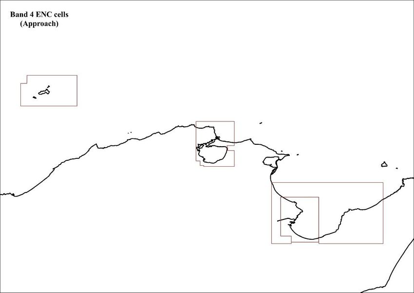
Problems encountered: N.T.R
5. MSI
Existing Kelibia Navtex station.
infrastructure for
transmission
New infrastructure in N.A
accordance with GMDSS:
Problems encountered: Kelibia Navtex station is not operational for the moment due to technical
problems.
As a provisional solution, the Tunisian navigational warnings are broadcasted
by the Maltese Navtex station until the Tunisian station will be ready and
operational.
The TNHOC is in process of acquiring a new Navtex station and hope to get
the new Navtex station operational by the end of this year.
6. C-55
Latest update See annex 4
7. Capacity Building
Offer of and/or demand for Need for training course in:
Capacity Building: Multibeam data assessment
Marine cartography (S-101, S-102 and S-104)
Tides and currents analysis and prediction
Training received: Multibeam echo sounder and side scan sonar systems workshop -
Istanbul (Turkey), from 24 to 28 October 2016.
Workshop on ENC production distribution in Istanbul (Turkey), from
02 to 06 October 2017.
Workshop on technical aspects of maritime boundaries in Istanbul
(Turkey), from 27 November to 01 December 2017.
Port and shallow water survey course in Genoa (Italy), from 17 to 21
September 2018.
Training offered: N.A.
Status of bilateral development projects with hydrographic component.
In progress:
Cooperation with Algerian Hydrographic Service
A bilateral agreement with the Algerian Hydrographic Service regarding the
publication and the distribution of the chart INT3208 is in progress.
Cooperation with the Italian Hydrographic Institute
The coproduction of the INT3212 with the Italian hydrographic institute is in
progress.
The last meeting of hydrographic expert was held via videoconference in
December 2020, the scope of this meeting is to assess the progress of the
INT3212 chart production.
The TNHOC and the Italian hydrographic institute have concluded a bilateral
agreement regarding the cooperation in the field of hydrography and
oceanography.
Planned: N.A.
Under study: N.A.
Definition of bids to IHO N.A.
CBC: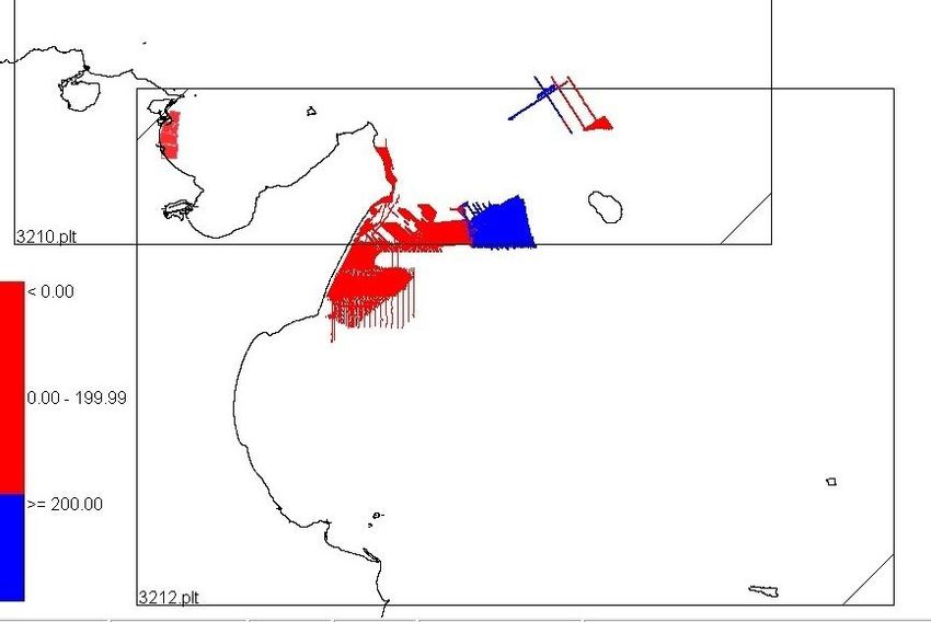
8. Oceanographic
activities
General: The TNHOC ensure the annual production and distribution of tide tables.
GEBCO/IBC’s activities: N.A.
Tide gauge network: The TNHOC implemented since 1987 a tide gauge network (six tide gauges)
to monitor the tide along the Tunisian coast. The tide network is there to:
• Tide data collection,
• Monitoring variations of the mean sea level,
• The determination of harmonic constants necessary for the
prediction of tides and the development of tide tables.
The TNHOC has renewed the existing mechanical tide gauge network with
seven digital tide gauge with real time data transmission.
New equipment: Pressure tide gauge OTT.
ADCP current Meter System: RDI Workhorse 300-600 m
Problems encountered: N.T.R.
9. Other activities Participation in IHO Working Groups:
Meteorological data collection:
Geospatial studies:
Disaster prevention: N.A
Environmental protection:
Astronomical observations: Magnetic/Gravity surveys:
10. Conclusions The TNHOC confirms that cooperation in the Mediterranean area still remains
the priority for all the countries involved.
To ensure the safety of navigation in the Tunisian waters, the TNHOC intends
to purchase new hydrographic assets and new hydrographic equipment in order
to continue performing hydrographic and oceanographic survey and producing
nautical charts with higher standards in all areas not yet surveyed.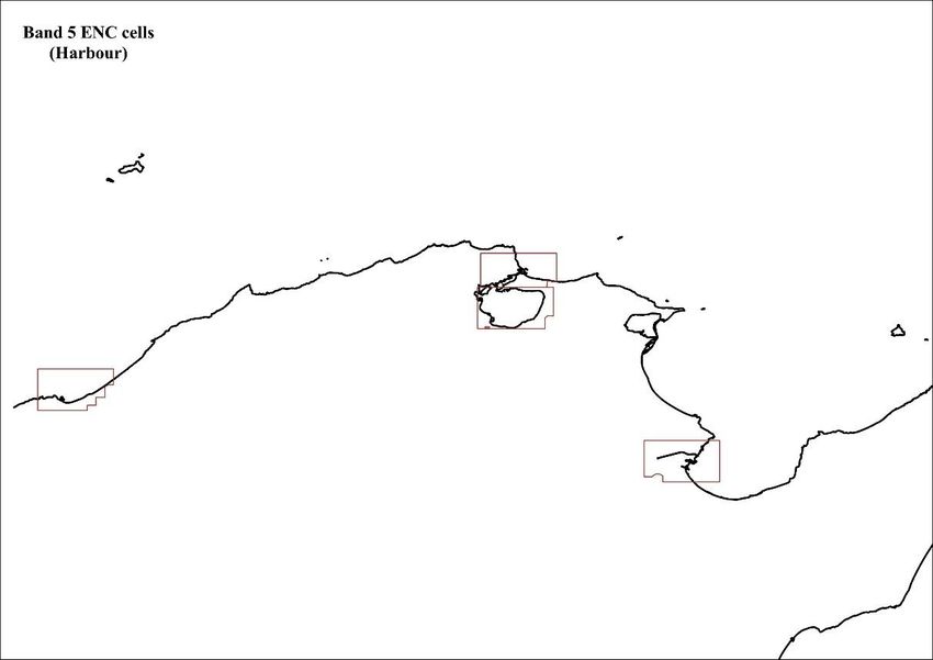
ANNEX 1

COVERAGE OF NEW SURVEYS
     (2019 - Mai 2021)
STATUS OF HYDROGRAPHIC SURVEYING
ANNEX 2

                 TUNISIAN ENCs COVERAGE

1. Band 3 ENCs

2. Band 4 ENCs
3. Band 5 ENCs
ANNEX 3
                         SCHEME OF INTERNATIONAL CHARTS

INT No.   National No.                 Title                   Scale          Status
 3208         250        De Ras El Hadid à Cap Zebib         1/250000   Achieved and will be
                                                                        published very soon
                         De Banzart à K’libia – Trapani et                   published
 3210         255                                            1/250000
                         Pantelleria
                         Da Ras El-Mir à Cap Africa –                       In progress
 3212         260                                            1/250000
                         Pantelleria e Isole Pelagie
INT No. National No. Title Scale Status
3283 1510 Port de Benzart et goulet du Lac 1/15000 Achieved
3284 1515 Ports de Halk El Oued, Rades et 1/15000 Achieved
Tounes
3285 1525 Port de Susah (Sousse) 1/15000 In progress
3286 1540 Port de Safaquis (Sfax) 1/15000 In progress
3287 1545 Port de Skhirra 1/15000 In progress
3288 1550 Port de Gannouche (Gabès) 1/15000 In progress
3289 1555 Port de Zarzis 1/15000 In progressANNEX 4
C55-Tunisia-20215050.pdf
C-55 Summary for: Comments on Charts:
Country: Country Tunisia According to the IHO (MBSHC), it was agreed
Iso Code: that TNHOC will produce international charts as
TUN follows :
Country
SubCode: INT Chart 3208 in cooperation with the
TUN-F Algerian HO (achieved).
INT Region:
F INT Chart 3210 in cooperation with the
Country/Depend:
C Italian HO (achieved).
Last updated: INT Chart 3212 in cooperation with the
Provided by: Tunisia Italian HO (surveyed at 25%).
INT Chart 3214 to be produced by the
TNHOC (surveyed at 25%).
Chart coverage Passage (%) Coastal (%) Port (%) INT Chart 3216 in cooperation with the
Libyan HO (surveyed at 20%).
INT 0 40 30 Comments on Surveys:
RNC 0 0 0 The hydrographic surveys for the northern
ENC 0 25 30 maritime area are achieved.
Status of Paper C harts The eastern maritime area is being surveyed
Paper charts with depths in meters (%) 100 since 2010.
Paper charts referenced to a satellite datum (%) 100
No
Adequate Resurvey
survey
(%) (%)
Status of surveys (%)
0-200m 55 45 0
> 200m 46 54 0
MSI Y/N Comments on MSI:
Local warning Y
Coastal warning Y
Nav warning Y Through NAVAREA III
Port warning Y
GMDSS Y/N Comments on GMDSS:
Master Plan N The GMDSS implementation responsibility lies on the merchant marine
Area A1 N administration.
Area A2 N All Tunisian merchant marine vessels comply with the IMO recommendations
Area A3 N regarding the GMDSS implementation.
Kelibia Navtex station is not operational for the moment due to technical
NAVTEX Y
problems. The TNHOC broadcast its related MSI via Malta station.
The GMDSS Implementation responsibility lies on the merchant marine
administration.
SafetyNet N
All Tunisian merchant marine vessels comply with the IMO recommendations
regarding the GMDSS implementation.
1213
You can also read