National Hurricane Center Snapshots
      1949 to present day
←
→
Page content transcription
If your browser does not render page correctly, please read the page content below
National Hurricane Center Snapshots
1949 to present day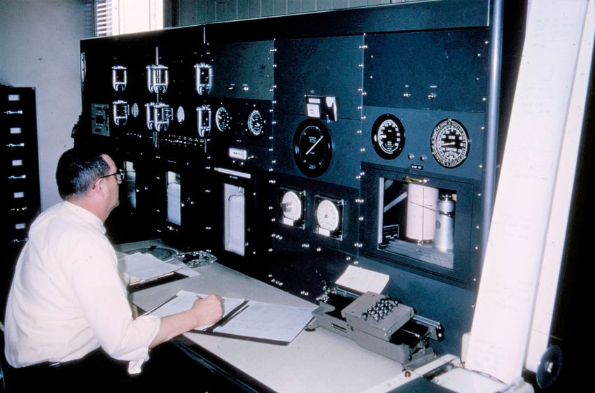
National Hurricane Center Locations

Lindsey Hopkins Building        Aviation Building         Univ. of Miami Computer Bldg.
  Miami, Fla. 1949-57          Miami, Fla. 1958-64        Coral Gables, Fla. 1964-1979

     One Gables Tower                         Florida International University
  Coral Gables, Fla. 1979-95                West Miami-Dade, Fla. 1995 to present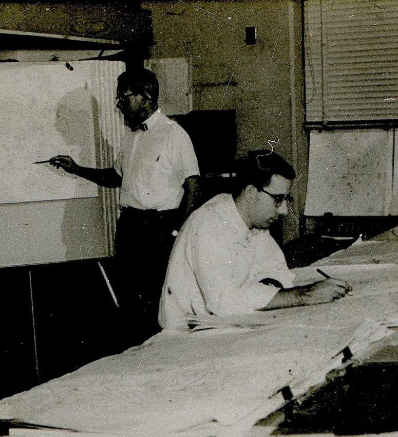
Receiving and sending information

                 Weather data was transmitted
                 and received via telephone
                 circuits using teletype machines.

 Circa 1950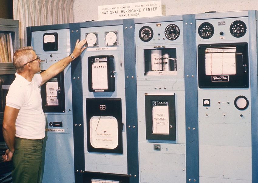
Public Communication

                Special equipment was set up
                at the facility by local media
                outlets to obtain weather
                information from forecasters.

Circa 1959
Receiving and sending information

                       In the 1960s, the
                       teletype remained the
                       most common method
                       to move data.

    W. Boyd, 1962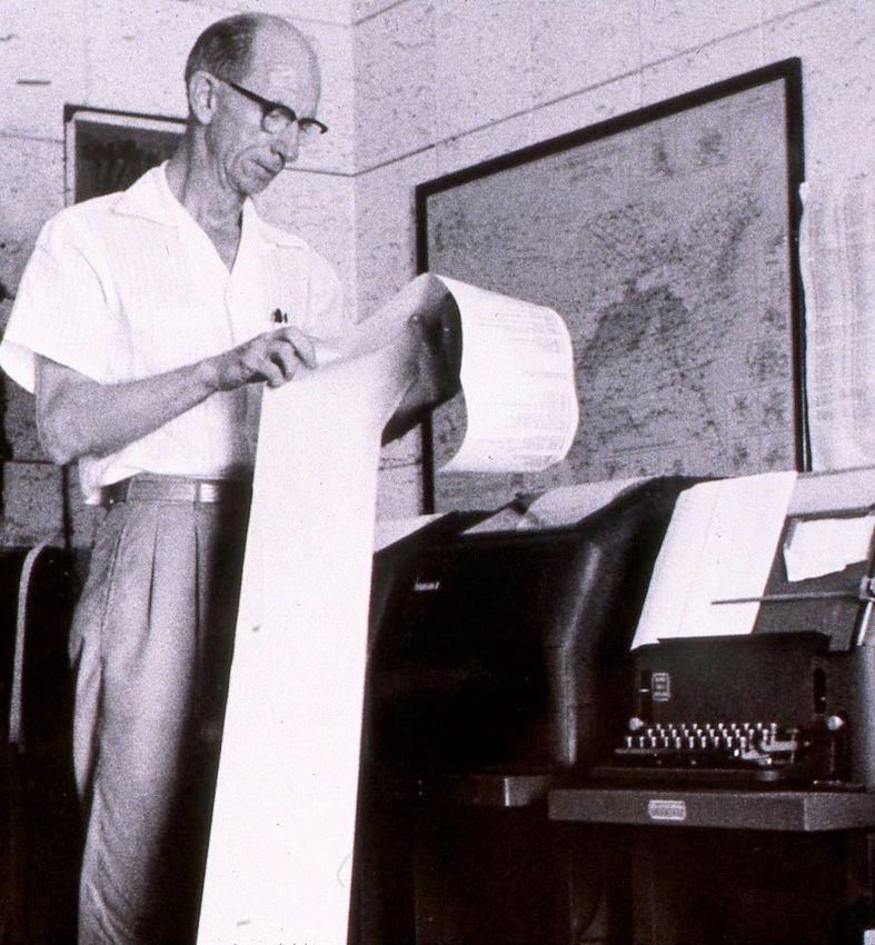
Public Communication

                                                        The National Hurricane Center and
                                                        the Miami Weather Bureau Office
                                                        were co-located at the facility.
                                                        There was a public number to call
                                                        to get the local weather forecast or
                                                        hurricane information.

Ken Poteat and Nate Ellis in the public service unit,
circa 1962.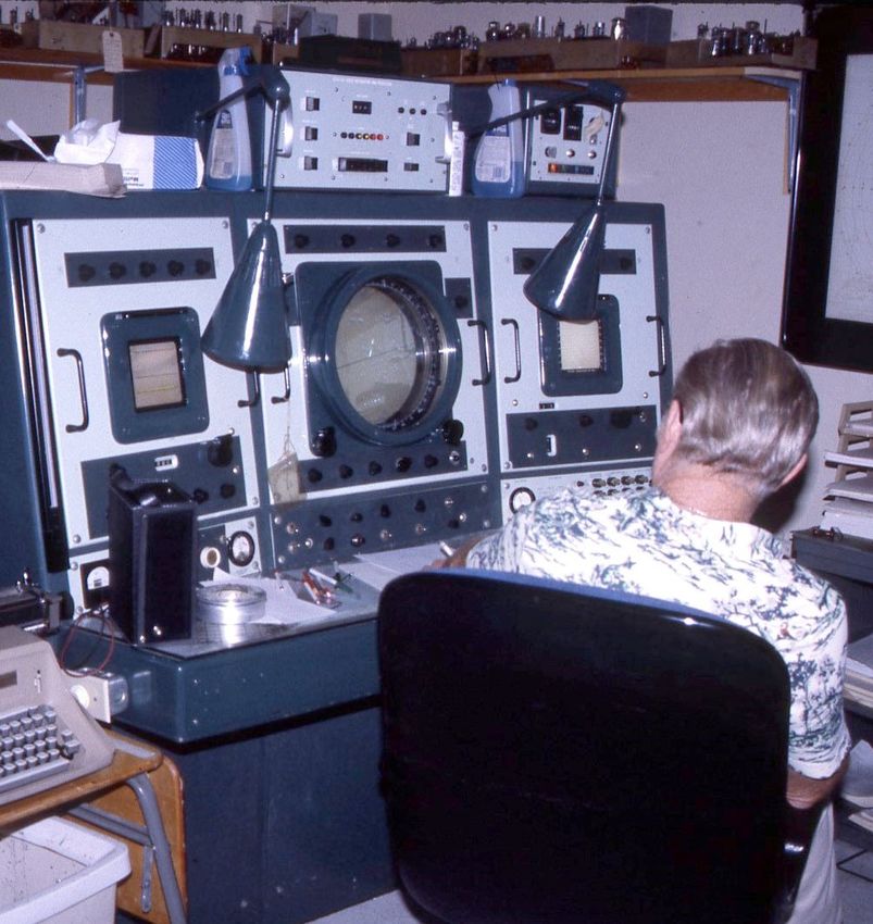
Radar Observations with the WSR-57
                                             The WSR-57 stands for Weather
                                             Surveillance Radar – 1957, the first
                                             generation of modern weather radar.
                                             The very first one was commissioned at
                                             the Miami Weather Bureau Office and
                                             National Hurricane Center and was later
                                             placed in other cities across the United
                                             States.

                                             Weather systems were traced by
                                             forecasters across the radar screen
                                             using grease pencils. A manual turn of a
                                             crank changed the radar's scan
                                             elevation to determine the height of the
                                             storm.
Radar specialist Eugene Wood at the WSR-57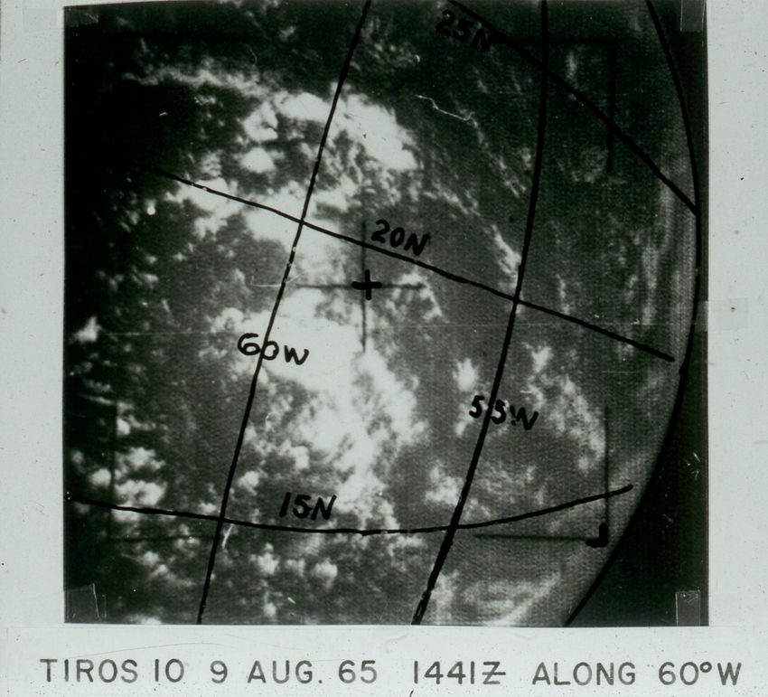
Observing the weather

                                            The temperature, dew
                                            point, humidity, wind
                                            speed     &    direction,
                                            cloud type and height,
                                            air pressure and rainfall
                                            are    observed      and
                                            recorded at least once
                                            an hour.

The meteorological technician, circa 1964
Keeping the records
                                                     Meteorological observations
                                                     and forecasts were placed
                                                     onto microfilm and stored in
                                                     large filing cabinets.

There are more than 200 containers in each drawer.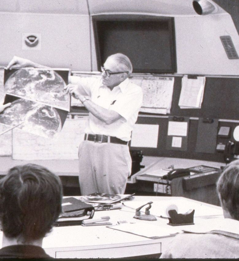
The Satellite Era arrives

With the 1960’s arrival of Tiros, Nimbus and        Images were transmitted to NHC
GOES, forecasters had an important analysis tool.   via phone line and received on a
                                                    special image processor.
Map Discussion
Discussions of the tropics took place
daily using facsimile weather charts
and satellite images.
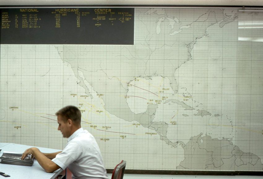
Hurricane Specialist Gil Clark, circa 1969The Wall Map
A large map located in the
hurricane operations area
displayed the progress of the
tropical activity during the
season.
Hurricane Specialist Dr. Neil Frank, 1971.Monitoring and recording the weather
As technology improved, so did
the instruments to measure the
temperature, dew point,
humidity, wind speed &
direction, cloud type and
height, air pressure and rainfall.
Francis Drybola - radar specialist, circa 1971Communications Room Specialized teletype machines included the Facsimile weather maps and satellite NOAA Weather Wire, Service A, Service C composites were received via phone line, and RAWARC circuits, circa 1971 circa 1971
Operations Area
                                            The primary function of the National
                                            Hurricane Center is to provide hurricane
                                            and marine forecasts for the tropical and
                                            subtropical Atlantic and eastern Pacific
                                            Oceans.

                                            During hurricane season, NHC is staffed
                                            around the clock by at least two
                                            hurricane specialists and two to three
                                            marine forecasters.

Paul Hebert and Robert Carson, circa 1972
The Charting Unit
Many of the charts used by
NHC forecasters were plotted
by hand, with an entire unit
dedicated to the task. At one
point, it was the largest unit at
NHC.
Mary Watson, Chief, Charting Unit, circa 1973Plotting and analyzing the data Student interns plot surface and upper air data onto charts for analysis, circa 1973.
HAM Radio Station at NHC
                                              In 1980, Amateur Radio Station
                                              WX4NHC was set up at NHC. It’s
                                              activated whenever a hurricane is within
                                              300 miles of landfall in the areas of the
                                              western Atlantic, Gulf of Mexico, the
                                              Caribbean Sea or the eastern Pacific.

                                              These reports provide the forecasters
                                              with supplemental weather and damage
                                              data that are not normally available to
                                              them, providing a human perspective
                                              and eyewitness accounts of what
WX4NHC Ham Radio Operator Julio Ripoll with   people are experiencing during the
NHC Director Neil Frank, 1980                 hurricane.
New equipment and a new look
The advancing computer age
brings new technology and a
fresh look to the hurricane
operations area in the 1980s.
The NHC Operations Area, circa 1988WMO classes begin
Since 1988, the National
Hurricane Center has hosted a
two-week training course with
meteorologists and decision-
makers from member nations of
the World Meteorological
Organization (WMO) Region IV.
Students are given instructions on how to use the many NHC
products, 1988Training for Emergency Managers
In 1992, NHC began hosting the
“Hurricane Preparedness Course
for Decision Makers”. The 5-day
training, coordinated with FEMA’s
Emergency Management Institute
(EMI), is designed for emergency
managers and decision makers of
each coastal U.S. state from
Texas to Maine. The course
includes a hands-on tabletop
exercise as a hurricane
The first training class of the Hurricane Preparedness Course approaches the coastline.
for Decision Makers, 1992. NHC staff seen here are Joe
Pelissier, Max Mayfield, Brian Jarvinen, Bob Sheets and Hal
Gerrish.The Media
Since the 1960s, many
media outlets have sent
cameras, microphones and
reporters to NHC to obtain
the latest information and
live interviews about the
approaching hurricane.
Local and national media surround NHC Director Dr. Bob Sheets
as Hurricane Andrew nears Miami, August 24,1992.A new home
Having sustained damage to its
facility from 1992’s Hurricane
Andrew and with the objective of
being co-located with a
university having compatible
curricula and vision, NHC and
NWS leaders moved forward
with their plan to relocate. NHC
moved into its own new building
on the campus of Florida
International University in May
1995.
The NHC building under construction in early 1995Making the decision
NHC Hurricane Specialists,
collaborating with their NWS
Forecast Office partners, use
their track and intensity forecast
and other considerations to
determine when and where the
watches and warnings will be
issued.
NHC Director Max Mayfield studies the track of Hurricane Charley, flanked by
hurricane specialist Richard Pasch and Monroe County Emergency Manager
Billy Wagner, along with specialists Lixion Avila and Eric Blake. Aug 11, 2004The Coordination Call
One hour before the
release of the latest public
advisory of a tropical
cyclone, the lead hurricane
specialist on duty conducts
a call with all of the
National Weather Service
offices in the watch and
warning area, as well as
other NWS agencies. It
would become a video call
beginning in 2018.
Hurricane specialist Jack Beven leads one of the many coordination
calls during the record 2005 hurricane season. Listening in are Stacy
Stewart, Billy Wagner, Max Mayfield, Ed Rappaport and Rick Knabb.Presidential visit
NHC has been
visited by two U.S.
Presidents.
President George W. Bush and NHC Director Max Mayfield, 2005.Refreshing the map wall
After more than 35 years
and two buildings, the
tracking map in the NHC
Operations Area was
updated.
Workers roll out the new track map, Sept 16, 2008Emergency Management briefings
Emergency Managers make
the difficult decisions regarding
evacuations ahead of an
approaching tropical cyclone.
NHC provides live virtual
briefings of the potential
hazards of the approaching
storm.
NHC Director Bill Read provides a briefing to FEMA regarding
Hurricane Earl, Aug. 31, 2010.Presidential Briefing
Every year, the President
receives a briefing from NOAA
regarding the upcoming Atlantic
hurricane season. In 2015, it took
place at NHC.
President Barack Obama is flanked by NOAA Administrator Kathy
Sullivan, U.S. Commerce Secretary Penny Pritzker and FEMA
Administrator Craig Fugate, May 18, 2015Opening the front door
A National Hurricane Center
open house allows the public
to see how it’s all done and
meet the forecasters.
Senior hurricane specialist Stacy Stewart discusses hurricane
operations with visitors, April 16, 2016.Media Day
On June 1st, the official start of
the Atlantic hurricane season,
NHC provides an opportunity
for media to obtain interviews.
Photographers obtain video of forecasters, June 1, 2017The NHC Media Pool
Live media interviews are
provided to national broadcast
& cable outlets and to local TV
stations located in the
hurricane watch/warning area.
Interviews are provided in both
Spanish and English by
hurricane experts from NHC
and NWS WFO Miami.
The NHC Media Pool as Hurricane Irma aims at South Florida,
Sept., 2017TAFB – Forecasting for Mariners
NHC’s Tropical Analysis and
Forecast Branch (TAFB) is
staffed 24 hours a day,
providing more than 100 marine
products covering more than 10
million square nautical miles.
TAFB also supports the United
States Coast Guard, providing
briefings for high impact events
such as tropical cyclones.
TAFB Meteorologist Eric Christensen leads a briefing to the USCG
District 7 regarding potential marine impacts from Hurricane Dorian,
Aug. 29, 2019Storm Surge
NHC adds Storm Surge
Watches and Warnings to its
public products beginning in
2017.
Storm Surge Specialists Cody Fritz and Heather Nepaul study the data
needed to create the graphic for expected storm surge from Tropical
Storm Fred, Aug. 14, 2021.Social media is added NHC Director Ken Graham and NOAA/NHC NHC Deputy Director Dr. Ed Rappaport Public Affairs Officer Dennis Feltgen with a prepares for a media interview via Skype, Facebook Live broadcast, 2020 2020 NHC adds Facebook Live in 2017, and Skype in 2020, to reach the growing social media audience.
This is a living document and will be updated as necessary. NHC
welcomes any new or corrected information. Please contact us at
nhc.public.affairs@noaa.gov
You can also read