DIGITAL MODELS APPLIED TO THE TYPOLOGICAL ANALYSIS OF THE OLIVE OIL MILLS WITH BEAM AND WEIGHT PRESSES IN ÉCIJA
←
→
Page content transcription
If your browser does not render page correctly, please read the page content below

Virtual Archaeology Review, 13(26): 116-134, 2022
                                                                                        https://doi.org/10.4995/var.2022.15077
                                                                                                            © UPV, SEAV, 2015

                                                                                                     Received: February 8, 2021
                                                                                                         Accepted: May 5, 2021

 DIGITAL MODELS APPLIED TO THE TYPOLOGICAL ANALYSIS OF THE
    OLIVE OIL MILLS WITH BEAM AND WEIGHT PRESSES IN ÉCIJA
MODELOS DIGITALES APLICADOS AL ANÁLISIS TIPOLÓGICO DE LOS MOLINOS ACEITEROS DE PRENSA DE
                                 VIGA Y QUINTAL DE ÉCIJA

                                Jorge Moya-Muñoz*             , Francisco Pinto-Puerto
        Departamento de Expresión Gráfica Arquitectónica, Escuela Técnica Superior de Arquitectura, Universidad de Sevilla,
                           Reina Mercedes 12, 41013 Sevilla, España. jmmunoz@us.es; fspp@us.es
Highlights:
•   The typological study of the Écija (Seville) mills with beam and weight presses reveals common patterns in these pre-
    industrial buildings.

•   The proportional relationships between their constituent parts obtained using digital information models enabled us to
    determine standard structures.

•   These patterns have similarly enabled us to generate a parameterised HBIM model as a standard graphical base for
    the historical mills in Écija.

Abstract
For centuries, mills with beam and weight presses have been the production units used in the town of Écija to obtain oil.
The intensification of olive tree cultivation in the 18th century increased the proliferation of these constructions throughout
the town, which at one point was home to no less than 286 mills of this type. However, the mid-20th century events
surrounding the local olive groves caused many of them to fall into disuse. Nowadays, the mills present an advanced
state of decay, to the extent that many of them have disappeared partly or completely. In view of the functional nature of
these production units and the short space of time in which they were built, the authors decided to conduct a typological
study aimed at identifying any common patterns in their design. The geometric and proportional relationships between
their constituent parts, obtained using digital information models (Geographic Information System (GIS), 3D point clouds
and databases), enabled us to determine standard structures based on ranges of deduced values. The repetition of
these patterns suggested that it would be useful to create a graphical database using a parameterised HBIM (Historic
Building Information Modelling), which in turn facilitates the introduction of attributes associated with these mills from a
dynamic database; this process would therefore favour interoperability in heritage management as a response to the
critical situation of the mills today. At the same time, the correspondence in the proportionality relationships between the
mills analysed typologically and the model of a 16th-century mill, suggests that 18th-century mills were adapted to
patterns developed in older presses.
Keywords: olive oil mills; typological analysis; digital information models; Geographic Information System (GIS); Historic
Building Information Modelling (HBIM); 16th-century olive presses

Resumen:
Los molinos de prensa de viga y quintal han sido las unidades productivas del olivar encargadas secularmente de la
obtención del aceite en el municipio de Écija (Sevilla). La intensificación del cultivo en el siglo XVIII hizo que estas
edificaciones se multiplicaran por todo el municipio hasta llegar a un total de 286 unidades. No obstante, a mitad del
siglo XX, los acontecimientos acaecidos en torno al olivar supusieron su desfuncionalización. En la actualidad, el estado
de conservación de los molinos es en general de abandono, desapareciendo parcial o totalmente muchos de ellos. El
carácter funcional de estas unidades productivas, así como el corto espacio de tiempo en el que fueron construidos, nos
lleva a plantear la necesidad de su estudio tipológico con el fin de conocer posibles patrones comunes en su diseño. Las
relaciones geométricas y de proporcionalidad entre sus elementos constituyentes obtenidas a partir de modelos digitales
de información: SIG (Sistema de Información Geográfica), nube de puntos 3D y bases de datos, permiten establecer
estructuras tipo a partir de rangos de valores deducidos. La repetición de estos patrones hace pertinente la creación de
una base gráfica mediante un modelo parametrizado HBIM (Historical Building Information Modelling), lo cual facilita la
incorporación de atributos asociados a los molinos desde una sencilla base de datos dinámica, favoreciendo la
interoperabilidad en la gestión patrimonial como respuesta a la situación crítica en la que se encuentran. Además, la
correspondencia en las relaciones de proporcionalidad, resultado del análisis tipológico de los molinos con el caso
mostrado de un molino del siglo XVI, evidenciaría la adaptación de los molinos del siglo XVIII a patrones desarrollados
en almazaras de mayor antigüedad.
Palabras clave: molinos de aceite; análisis tipológico; modelos digitales de información; Sistema de Información
Geográfica (SIG); modelado de información de la construcción (HBIM); almazara s. XVI
*Corresponding   author: Jorge Moya Muñoz, jmmunoz@us.es

                                                                                                                              116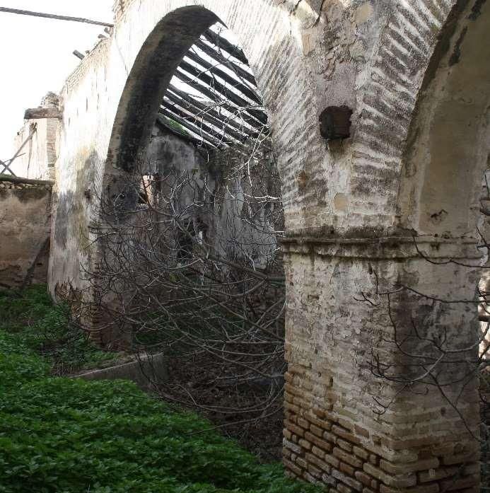
DIGITAL MODELS APPLIED TO THE TYPOLOGICAL ANALYSIS OF THE OLIVE OIL MILLS WITH BEAM
                                   AND WEIGHT PRESSES IN ÉCIJA

1. Introduction                                                    (Martín, 1990; García-Dils, et al., 2006; Ordóñez &
                                                                   García-Dils, 2006).
Beam and weight presses have been the production
units used for centuries in the town of Écija (Seville             The vast quantity of olive trees planted naturally led to
province) to transform olives into oil. The strong                 an increase in the number of olive oil mills,5 to the extent
international demand for oil, the increase of domestic             that between the 18th century and the second half of the
consumption both as a food product and as an industrial            20th century 286 were identified (Moya, González &
lubricant, the profitability obtained from olive groves            Rodríguez, 2020) (Fig. 1).
compared with other dryland crops, and the distinction
that land ownership conferred on the elite classes, all
contributed to the vast expansion of the Écija olive
groves that commenced in the 17th century1 (García-Dils,
Ordóñez, Sáez, Venegas & Rodríguez, 2006). This
expansion not only necessitated the reconversion of
crops such as vines and cereals but even exacted a cost
on royal lands, pastures and barren land (García, 1981).
However, the heyday of olive tree cultivation occurred in
the 18th century as a result of additional factors:
demographic growth, the demise of the Mesta sheep
raisers guild, the diminished consumption of animal fats
and the liberation of the market (Trujillo, 1995).
In the 19th century, following periods of shrinkage, the
olive groves began to expand again, partly to meet the
growing international demand and partly as a result of
the abolition of the feudal system and the disentailment
of the Church's landed property (Granados, 2009). The
advent of the “oil train”, with a branch line connecting
Écija to Córdoba, and improved communication routes
also played a significant role in the commercialisation of
olive oil (Millán, 2005).
The 20th century brought a boom in exports and
consolidated the so-called golden age of the Écija olive            Figure 1: Site map of the Écija olive oil mills and the historical
                                                                       olive groves in the mid-20th century, identified using GIS.
groves. After the Spanish Civil War, the government’s                  Source: The authors, based on data from the Écija Land
protectionist measures ensured the continued cultivation            Registry provided by Écija Town Council and the vectorisation
of olive trees until the middle of the century, even though           of the olive groves using the orthophotos of the American
oil was a structurally surplus product. However, from that            Flight, Series A, obtained from the Spanish Geographical
point on the olive sector entered a crisis as a result of                                   Institute (IGN).
the demand for labour in cities and the increase in
disposable income. This latter factor not only prompted a          According to the General Responses of the Ensenada
greater demand for vegetable oils, leading to the growth           Land Registry (1751), in the mid-18th century, there were
of oilseed crops, but did away with the protectionism              249 olive oil mills in Écija.6 Thereafter, the number of
previously conferred on olive groves (Rallo, 1986). Even           these constructions remained relatively unchanged
so, the greatest reconversion of the olive groves                  (some disappeared while new ones emerged) until the
occurred at the beginning of the 1970s (Guzmán,                    mid-20th century, when they fell into disuse as a result of
Hernández, Gómez & Lora, 2020), in the wake of                     the agricultural dynamics described above that led to the
Decree 1.10/10722 (Spain, Departement of Agriculture,              first olive growers' cooperatives. Meanwhile, the incipient
1972). The measures introduced by this decree led to               modernisation of farming ushered in the use of
the virtual eradication of olive trees in the town of Écija3       machinery, which necessitated the provision of large
(Moya & González, 2019).                                           spaces to house them and meant that many of the
                                                                   exterior and interior spaces of the mills had to undergo
These olive groves historically occupied two clearly
                                                                   significant alterations (Moya, 2019), such as the
identified areas: the “Moorish Strip” and Valcargado4
                                                                   reorganisation of courtyards, the creation of new
                                                                   openings, the vacation of the original facilities, the
1
                                                                   demolition of certain areas, etc.
   In earlier times, such as the Islamic period, olive tree
cultivation was less important, although exports continued
during the Caliphate and Emirate periods (Guzmán, 2007).
2
   Decree 1010/1972 of 13 April on the reconversion and            the Moorish Strip; the ones on the other side, towards Seville,
reorganisation of oil production.                                  are called Valcargado (“heavily laden”), because of the
3
  In 1922 the Écija olive groves occupied 27,258 ha according      abundance and excellence of their fruit compared with the
to the Agricultural Department, while in the 20th century they     others.”
                                                                   5
occupied 3720 ha (Guzmán, 2004).                                     There are records of this type of mill in Écija dating from at
4
  The Écija olive groves are thought to have occupied these        least the 16th century. The Seville Notarial Records list rural
areas since Roman times, coexisting in the remainder of the        contracts up to the 18th century and include 31 contracts for oil
town with other crops as a type of olive meadowland (Ordóñez       press renovations and constructions. One of these contracts is
& García-Dils, 2017). In his book Ecija, sus santos, su            accompanied by a plan which is analysed in Section 4.4 of this
antiguedad eclesiastica i seglar, Father Martín Roa (1629)         article.
offers the following description: “The olive groves occupy three   6
                                                                     The Ensenada Land Registry (1751) lists 254 beams for the
leagues before and just as many after the city. The ones on this   town of Écija. Bearing in mind that nine mills with double beams
side of the River Genil, on the road to Córdoba, are known as      have been identified, we estimate the number of mills to be 249.

Virtual Archaeology Review, 13(26): 116-134, 2022                                                                                  117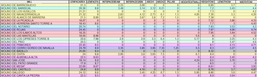
MOYA & PINTO, 2022

As another consequence of these dynamics and the                             • Many of the mills in Écija do not have any form of
rural exodus to industrial areas, a considerable number                        official protection even though they represent very
of mills were abandoned. Table 1 shows the changes in                          interesting models (Fig. 2).
the number of mills since the 18th century.                                  • The state of repair of the mills, more than a decade
                                                                               after the inventory was created, is naturally worse
                   Table 1: Écija olive oil mills.                             today, and many of them present advanced decay.
       Year        No. of mills                Source                        • The preliminary nature of the inventory, as indicated
       1751            249            Ensenada Land Registry                   in Section 2.3 of the PGOU, Singular Buildings in
                                                                               the Rural Environment, calls for a revision of the
       1773            261           Diccionario Geográfico de                 classification and description criteria which are used
                                              Madoz7                           to propose the different forms of protection
       1851            251        Breves apuntes de la ciudad de               applicable to historical olive oil mills.
                                              Écija                          • It is necessary to create agile and accessible tools
       1858            249                Écija name index                     to facilitate the interdisciplinary management of this
                                                                               important heritage.
       1865            255           Écija manual or yearbook

       1873            276              Cartographic records

      1910-25          275             Topographical studies

       1958            279               Topographical map

      1975-77          275        Inter-ministerial orthophoto flight

       1985            267           1984-85 orthophoto flight

       2000            216             2000 orthophoto flight

       2020           1998                    Field trips

As shown in Table 1, olive oil mills have disappeared
increasingly with the passage of time. It was precisely
this vulnerable situation of the mills and other rural
constructions in Écija that led the town council to
provisionally amend Section 5a of the Urban Planning
Regulations and By-laws of the 2009 Land Use Plan
(PGOU) by inserting an inventory of singular buildings in
the rural environment, including the olive oil mills. These
Regulations identify 129 mills, of which, according to the
PGOU, 47 were in a good state of repair, 38 in a state of                  Figure 2: El Gallego mill in Écija. This mill is assigned low
neglect and 44 in a state of ruin. With regard to the                    architectural interest in the PGOU inventory, which means that
                                                                                   it currently has no form of official protection.
architectural interest which the same PGOU attributes to
these buildings, 27 were considered to be of high
interest, 63 of medium interest, 25 of low interest and 14              2. Objectives and methodology
of zero interest. Consequently, the mills considered to be
                                                                        The purpose of this research project is to increase the
of high or medium architectural interest (90) have three
                                                                        existing knowledge about the mills and enhance public
kinds of official protection9 (structural, environmental and
                                                                        appreciation of the agricultural heritage of the Écija olive
precautionary) as recorded in Volume I of the PGOU
                                                                        groves. The methodology is based on the assumption
Inventory of Protected Assets.
                                                                        that the mills, as oil production units, are just one of the
This information sheds light on several aspects that are                diverse features of the historical olive groves and
relevant to the consideration of the mills as heritage:                 therefore not the only assets that potentially merit official
                                                                        protection (Moya et al., 2020). However, this article
    • The PGOU only identifies 129 mills in Écija, while                focuses exclusively on the olive oil mills, specifically on
      the analysis of orthophotos and the field trips                   the typological aspects related to their morphology and
      identified 199 in 2020.                                           geometric proportions in the context of the spaces that
                                                                        define them. We, therefore, set out to demonstrate the
7
                                                                        results obtained by creating and using different digital
  The Diccionario Geográfico de Madoz Pascual (1847) cites an           models (GIS, 3D point clouds, databases and HBIM) as
“infinite” number of mills with 50000 aranzadas (unit of
                                                                        mechanisms for providing knowledge about these mills10
measurement equivalent to 3672 m2) of olive groves, while also
referring to a report presented to Écija Town Council in 1773           and therefore tools for their heritage management.
which specifies the number of mills and states as 42210                 The methodology to achieve these aims is based on the
aranzadas the area occupied by olive groves.
8                                                                       following series of sequential stages (Fig. 3):
  This figure refers to the number of mills that retain part of their
original structures, which may be in an advanced state of
decay. This aspect is explained in more detail below.
9
  The list includes the mills identified in the publication Cortijos,
haciendas y lagares: arquitectura de las grandes explotaciones
agrarias de Andalucía. Provincia de Sevilla (Granados, 2009)
                                                                        10
as well as the ones assigned medium or high interest in section            The only data the PGOU provides is a list of mills with some
1.5 Buildings in the Rural Environment of Volume I of the PGOU          form of protection, accompanied by their name and
Inventory of Protected Assets (2009.                                    geographical coordinates.

Virtual Archaeology Review, 13(26): 116-134, 2022                                                                                    118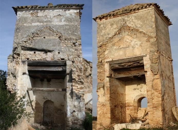
DIGITAL MODELS APPLIED TO THE TYPOLOGICAL ANALYSIS OF THE OLIVE OIL MILLS WITH BEAM
                                      AND WEIGHT PRESSES IN ÉCIJA

     • Geolocation of the existing mills in Écija11                  Inter-ministerial Photogrammetric flight conducted in
     • Identification of the functional structure of the mills       Écija in 197713 (Fig. 4).
       and their current state
     • Definition of study parameters and their subsequent
       analysis
     • Evaluation of the multiple relationships generated by
       the results
     • Case study of the relationships focused on an Écija
       mill dating from the 16th century
     • Generation of an HBIM model as a three-
       dimensional graphical base of a standard mill.

                                                                       Figure 4: Geolocation of the Eslava mill using GIS and aided
                                                                      by the 1873 Cartographic Records, the 1951-58 Land Records
                                                                             and the flights undertaken in 1956-57 and 1977.
                                                                         Source: IGN for a) and c), Écija Town Council for b) and
          Figure 3: Flowchart of the methodology followed.                                    REDIAM for d).

The details provided below form part of a set of results             3.2. Functional description
obtained within the D1 action line of the R+D+i project              The Écija olive oil mills were oil-producing units with a
TUTSOSMOD.12                                                         distinct functional character and the buildings, therefore,
                                                                     had to be structured in a manner that permitted the
3. Beam and weight mills                                             storage of the harvested olives,14 their transformation
                                                                     into oil, and finally their storage in cellars. At the
3.1. Geolocation                                                     same time, there also had to be spaces for use by the
                                                                     people temporarily employed15 at the mill, such as
For the geolocation of the mills, we began with a list of            labourers’ living quarters, kitchens and pantries, shelters
georeferenced mills provided by Écija Town Council in                for the draught animals, such as stables, and barns to
shape format, which enabled us to identify the location of           store wheat.
the 129 mills initially identified.
                                                                     The mill was also complemented by a series of external
As explained above, this figure differs from the real                elements, such as pigpens, pigeon lofts, threshing floors,
number of mills currently existing in Écija and we,                  kilns, wells, cisterns, etc. The layout of the spaces at a
therefore, used GIS to geolocate all of these buildings              mill is shown in Figure 5, based on the ground plan of
according to the methodology proposed by Moya &                      the Charcón mill in Écija.
Atanasio (2020). As aids for this task, we used the list of
mills in the yearbook Anuario ecijano (D.A.G & D.M.C.,               The oil-producing activities were conducted around a
1865), the Cartographic Records published by the                     closed courtyard, accessed directly from the outside.
Geographical Institute in 1873 and the Topographical                 The olives were unloaded and weighed in this space
Land Records of the Geographical Registry Institute                  before being stored in the barns. In some cases, there
drawn up in Écija between 1951 and 1958. We obtained                 was a second courtyard, often connected to the main
the Cartographic Records directly from the Web Map                   house16 (Table 2).
Service (WMS) of the IGN (National Geographical
Institute) and the Land Records from Écija Town Council
in the form of a raster file. Using these graphical
bases we were able to geolocate all the olive oil mills in
the town. In view of the predictably scattered nature of
the Cartographic Records, we had to cross-check the
location of the mills against the information from
the Land Records, going through the IGN to consult the
                                                                     13
WMS orthophotos from the flights undertaken by the                        The date of the flights conducted between 1977 and 1983
US ARMY (Series A 1946-47 and Series B 1956-57)                      can be consulted for each area of Andalusia on the REDIAM
and through REDIAM (Environmental Information                        website.
                                                                     14
                                                                         The olive boom not only led to the construction of new mills
Network of Andalusia) to consult the National                        but to the adaptation of many of the existing farms along the
                                                                     same lines to address the same needs (Infante, 2014).
                                                                     15
11
                                                                          During the harvesting period the mills adopted the form of
   The study of the olive groves and these production units must     little settlements and in some cases even included chapels and
naturally be conducted at a supra-municipal level (Moya et al.,      oratories due to the labourers being unable to travel to Écija
2020). However, for this article, the research is delimited by the   until their work had finished (Pradas & Gómez, 2005).
perimeter of the town of Écija.
12                                                                   16
   Sustainable comprehensive management of cultural heritage            The existence of the main house was the architectural
through digital BIM and GIS models: Contribution to knowledge        response to the residential needs of the mill owners who
and social innovation social.                                        wanted to oversee the pressing process from close quarters.

Virtual Archaeology Review, 13(26): 116-134, 2022                                                                                119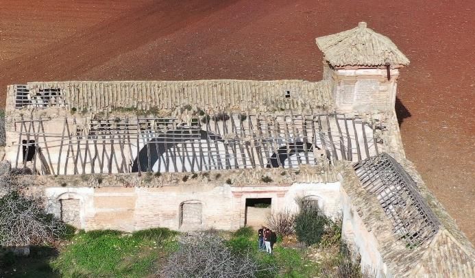
MOYA & PINTO, 2022

                                                                      the olive press used to produce the oil, which was
                                                                      divided into two connecting spaces: the beam area and
                                                                      the grinding area.
                                                                      The olives were transported from the courtyard to the
                                                                      press where they were ground with a cone-shaped stone
                                                                      roller turned by the animals. The paste obtained from
                                                                      this process was then taken back to the beam area
                                                                      where it was loaded into esparto grass baskets,
                                                                      organised in a stack, ready for pressing. This was done
                                                                      with a large beam (13-18 m17 judging from the length of
                                                                      the facilities observed), which the grinder and two
                                                                      foremen activated manually by turning a spindle
                                                                      connected to a heavy stone weight (the quintal) at the
                                                                      other end of the beam. The beam remained in this
                                                                      position for several hours to obtain the maximum
                                                                      quantity of oil.
                                                                      At the end of this pressing process, the beam was raised
                                                                      by turning the spindle and the oil was poured into large
                                                                      semi-buried jars in the cellar. The new position of the
                                                                      beam required an additional element to compensate its
                               (a)                                    mass, namely a counterweight tower. Adjacent to this
                                                                      structure was a hearth where water was heated and then
                                                                      poured onto the baskets to obtain a larger quantity of oil
                                                                      from a second press. This grinding process was
                                                                      often repeated in two shifts during the course of the
                                                                      24 hours that the grinding mechanism was in operation.
                                                                      At the end of the process, the oil was ready for sale
                                                                      and distribution.18
                                                                      The assimilation of the oil production process sheds light
                                                                      on the particular characteristics of the spaces inside the
                                                                      press, where the geometry obeys the need to
                                                                      accommodate certain elements (grinding stone, jars for
                                                                      storing the oil, beam, counterweight tower) and provide
                                                                      space for three people (a master grinder and two
                                                                      foremen) and an animal (mule or donkey) to do their
                                                                      work. In the case of the Écija mills, the press tends to
                                                                      adopt the same typology. The constant repetition of a
                                                                      standard type of model is the product of earlier planning
                                                                      that had proved its efficiency (Herrera, 2002). The press,
                                                                      therefore, appears to have remained unchanged until the
                                                                      mills fell into disuse in the mid-20th century, and as a
                                                                      result, they provide valuable information about the
                                (b)                                   typological veracity of the Écija mills.
 Figure 5: (a) Roofs and ground plan; (b) of the Charcón mill in
    Écija. 1: Courtyard. 2: Labourers’ living quarters. 3: Porch.     3.3. The current state of the mills
 4: Stables. 5: Kitchen. 6: Entrance. 7: Cellar. 8: Grinding room.
              9: Beam room. 10: Counterweight tower.
                                                                      Before analysing the typology of the presses, we studied
                                                                      the current state of the mills to verify the extent to which
                                                                      the constituent parts have been preserved. We began by
Table 2: Number of courtyards at the Écija olive oil mills.
                                                                      working with orthophotos, in this case, the satellite
                                                                      images obtained from the Landsat 8 of the US
     Unknown                   One                   Two
                                                                      Geological Survey conducted in 2017 and 2020. These
         63                    189                    34              enabled us to identify the mills that had disappeared
                                                                      completely, the mills where only the counterweight tower
                                                                      had survived, the ones that still had the tower and an
The courtyard where the olives were stored was
surrounded by two or three buildings, depending on the
                                                                      17
mill. One of them, as in the case of the Charcón mill,                   According to Payo (1840), the length of the beam varied
would house the stables, adopting the form of open,                   between 15 and 20 varas (12.53 m-16.7 m). The beam at the
narrow space for the draught animals used to turn the                 Puntales mill was 17m long according to data obtained by
stone roller or transport the olives from the groves.                 López (2012).
                                                                      18
                                                                         The description of the oil production process was obtained by
The kitchen and pantry were adjacent to this space and                interviewing the former grinder, the Écija resident Fidel
led up to a second level. Situated on the other side of               Rodríguez Rodríguez (personal interview, 25 February 2020),
the courtyard were the living quarters for the olive                  who told the authors that two grinding processes per day were
pickers or labourers, also directly accessed from the                 carried out, each of them with a weight of 10 fanegas
outside, and the porch that provided shelter for the                  (432.5 kg), a value that coincides with López (2012) but differs
animals. The last space adjacent to this courtyard was                from the figure provided by Delgado (2012), who refers to 14-20
                                                                      fanegas per day (600-865 kg).

Virtual Archaeology Review, 13(26): 116-134, 2022                                                                                 120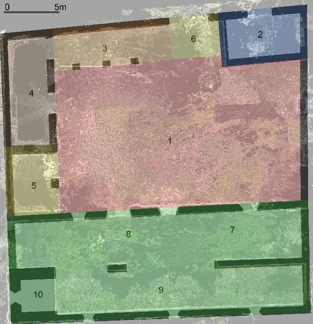
DIGITAL MODELS APPLIED TO THE TYPOLOGICAL ANALYSIS OF THE OLIVE OIL MILLS WITH BEAM
                                   AND WEIGHT PRESSES IN ÉCIJA

odd building, the ones with only one building still                The elements studied are defined in Figure 7 and Table
standing, and the mills where all the volumes are still            5 and are shown in Figure 8.
present (Moya et al., 2020). We traced these details by
superimposing the orthophotos on the mills which we
had previously geolocated with GIS.

                                                                       Figure 7: Location of the elements studied in the press.

   Figure 6: Site map of the mills according to their current
                          structure.
                                                                                                   (a)

Once we had gathered sufficient information, we
organised a series of field trips to check and supplement
the data obtained in the previous phase. To optimise
resources and speed up this process, we divided the
town into zones and created 18 different routes for
visiting all the mills. The results of this phase are shown
in Figure 6 and Tables 3 and 4, which clearly
demonstrate the different states of repair presented by
the mills today.

   Table 3: Site map of the Écija olive oil mills, 2020, without
                 considering the state of repair.
     Only    Preserves       Preserves Preserves all Remains
preserves the an odd         tower and the original of an odd                                      (b)
    tower     building         an odd    structure     wall
                                                                    Figure 8: (a) Charcon mill; (b) Gallego mill. At these, we were
                              building
                                                                   able to identify the beam area, grinding area and counterweight
     21              57          58            58            5                                   tower.

          Table 4: Use of the Écija olive oil mills, 2020.
           Abandoned                            In use
                69                               130

4. Typological analysis
4.1. Elements and parameters studied
After analysing the mills in general and their current
state of repair, we conducted a typological analysis. This
focused on the formal, compositional and building
elements of the press but did not include the decorative
elements (cornices, mouldings, weather vanes, sundials,                                 (a)                            (b)
etc.), which clearly are also important aspects of their
                                                                     Figure 9: Álamos Bajos mill in Écija. Years: (a) 1977; and (b)
typological categorisation and merit further study. Based             2017. These images enabled us to identify the approximate
on these criteria, we divided the press into three zones:          dimensions of the press, its orientation, the existence of a single
beam area, grinding area and counterweight tower.                   courtyard, and the arches between the different areas. Source:
                                                                                     REDIAM and Google Earth.

Virtual Archaeology Review, 13(26): 116-134, 2022                                                                                 121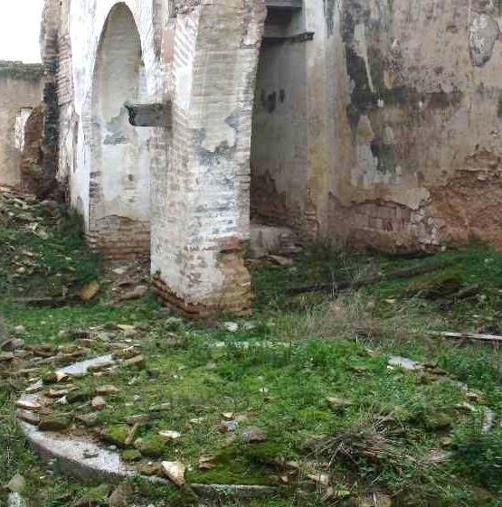
MOYA & PINTO, 2022

      Table 5: Elements and parameters studied in the press.          in 1977 and the satellite images from Landsat 8 of the
                            Beam area
                                                                      US Geological Survey conducted in 2017 and 2020.

Element                           Parameter                           We also determined the orientation of the press to relate
                                                                      the position of the building with respect to openings on
Exterior wall    Length       Height       Openings     Building      the exterior walls (Fig. 9).
facing area                                             system
                                                                      4.2.2. Field trips
Exterior wall    Length       Height       Openings     Building      By following the various routes scheduled for the field
   facing                                               system        trips, we managed to visit all the mills where some of the
  facade                                                              constituent parts are still standing. Of the existing 199
                                                                      mills, we accessed either the immediate vicinity or the
     Interior    Length       Width                                   interior space of 140 mills. We photographed the
      space                                                           remainder from the closest point we were able to
      Roof      Height19                                Building      access.
                                                        system
                                                                      To identify and obtain the different parameters, we used
                           Grinding area                              a camera, a laser distance meter, a flushometer, a tape
                                                                      measure and, in certain cases, a drone fitted with a
     Element                      Parameter
                                                                      camera (Fig. 10). We used graphical data sheets to
Exterior wall   Length        Height       Openings    Building       record the information from the data obtained, on which
facing area                                            system         we noted all the aspects defined in Table 5 before
                                                                      transferring them to a database.

Exterior wall   Length        Height       Openings    Building
   facing                                              system
  facade

     Interior   Length        Width
      space
Intermediate     Span       Height of       Chord      Building
wall (Arch 1)               keystone                   system
                            from floor

Intermediate     Span       Height of       Chord      Building
wall (Arch 2)               keystone                   system
                                                                             (a)                            (b)
                            from floor
                                                                      Figure 10: The Charcón mill in Écija: (a) Positioning of targets;
      Roof       Height                                Building                    and (b) drone flight to gather data.
                                                       system
                                                                      4.2.3. Dimensional values of the building systems
                        Counterweight tower
     Element                      Parameter                           As explained in Section 3.2, there is an evident
                                                                      typological uniformity in the presses at the Écija mills.
     Exterior    Length       Width         Height      Building      This undoubtedly bears relation to the type of systems
      space                                             system        used to build them. We observed a similarity in the
     Interior    Length       Width                    Openings       building solutions adopted for the various elements
      space                                                           (types     of   walls,   corner    solutions, openings,
                                                                      reinforcements, etc.) and the widespread use of local
4.2. Data collection                                                  materials, denoting an evident adaptation to the
                                                                      immediate environment. This aspect had a clear impact
The data were obtained from the study elements by                     on the data collection, because although we were able to
means of orthophotos, data gathered on field trips, a                 identify the building system it was not always possible,
series of common parameters assigned to different                     for a variety of reasons, to verify certain dimensional
building systems and others extracted from historical                 values. The uniformity of building solutions, therefore,
records.                                                              enabled us to establish unknown measurements by
                                                                      examining the photographs obtained. As a reference, we
4.2.1. Orthophotos                                                    also used the description of the building process for a
                                                                      16th-century press found in bundle 358 in the Écija
The orthophotos were mainly used to obtain
                                                                      Notarial Records (APNE), which contains similar
approximate dimensional values of the press, based
                                                                      processes.
on the assumption that we would not be able to access
many of the mills due to private ownership and that                   With regard to the walls around the grinding area and
it would therefore be difficult to obtain these parameters.           the beam area, these are basically made of rammed
We used GIS with the aforementioned National Inter-                   earth. In certain cases, they can be classified as simple
ministerial Photogrammetric flight undertaken in Écija                rammed earth walls, as in most of the rammed earth
                                                                      constructions in Seville province (Graciani & Tabales,
                                                                      2009), but the most widespread typology is rammed
19
  This height refers to the ridge. The height of the roof gables is   earth with mortar (with single, double or triple brick
included in the height of the wall.                                   courses) (Moya, González & Rodríguez, 2021). As for

Virtual Archaeology Review, 13(26): 116-134, 2022                                                                                  122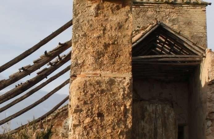
DIGITAL MODELS APPLIED TO THE TYPOLOGICAL ANALYSIS OF THE OLIVE OIL MILLS WITH BEAM
                                      AND WEIGHT PRESSES IN ÉCIJA

the height, more than half of the cases analysed were of              They are made of sequences of mixed rammed earth
the low module variety, with approximate dimensions                   walls delimited by brick buttresses at the front corners,
of 1 vara (83.59 cm), while the remainder were of the                 and as a result, they did not need to conform to a
high module variety20 (Table 6).                                      specific measurement.21 However, we were able to verify
                                                                      the wall thickness in 40 of the mills studied (Fig. 13).
         Table 6: Heights of the rammed earth wall modules.           This thickness is made up of various types of brick
                                                                      bonds, which enabled us to identify the various
 Rammed              82    83      84     87      90     92     96    thicknesses. Table 7 shows the values obtained and the
 earth wall                                                           bonds identified.
     Height (cm)
      Mills (34)     4     12      5       6       3      2      2

Despite the difficulty of obtaining accurate data about the
real length of the rammed earth walls, we were able to
define four values: three of them (163, 167 and 170 cm)
are related to two Castilian varas (167.18 cm),
corresponding to the low module variety, while the other
value, 195 cm, is associated with the high module
variety. Specifically, bundle 358 states that “the rammed
earth walls must be one vara high and two varas long,
as customary”. In other words, these measurements
would not only have been used in the specific mill
described in the document but constituted commonly
adopted values, as we were able to verify.
Of the 30 mills where we obtained the dimensions, in 29
cases the walls were 65 cm thick and 55 cm thick in one
case. It is important to remember that the first
measurement corresponds to the sum of two stretcher
bricks (Fig. 11).
The document containing the description of the 16th-
century press also refers to the wall thickness, where in
relation to the mill walls the builder states that “two                Figure 12: Pillar between arches at the Cipreses mill in Écija.
bricks form the walls all round”.                                      Its dimensions are 130 x 65 cm, corresponding to the sum of
                                                                                   two and four stretchers, respectively.
With regard to the pillar separating the arches in the
area, while the thickness corresponds to two stretcher
                                                                       Table 7: Type of brick bond on the walls of the counterweight
bricks (wall thickness), the length varies according to the                              towers at the Écija mills.
number of pieces of brick used, and the dimension
therefore depends on the mechanical characteristics of                                     The side wall of the tower
the arches (Fig. 12). Bundle 358 at the APNE does not                        Bond type           Dimension       Number of mills (40)
make reference to this dimension.                                                                   cm

With regard to the counterweight tower, the dimensions                      2 stretchers             0.65                 3
of the exterior and interior walls vary, as explained in
                                                                      2 stretchers + 1 header        0.78                 3
Section 4.3 below.
                                                                      1 stretcher + 4 headers        0.88                 5
                                                                           2 stretchers + 2          0.92                 9
                                                                               headers
                                                                            3 stretchers             0.96                21
                                                                      3 stretchers + 1 header        1.1                  8
                                                                                           The front wall of the tower
                                                                             Bond type           Dimension       Number of mills (38)
                                                                                                    cm
                                                                             4 headers               0.56                13
                                                                            2 stretchers             0.64                 4
                                                                      2 stretchers + 1 header        0.78                12
                                                                      1 stretcher + 4 headers        0.88                 2
     Figure 11: Detail of the rammed earth wall with mortar and a
      single brick course that separates the different areas at the         3 stretchers             0.96                 2
       Gallego mill in Écija. It clearly shows the thickness as two
                              stretcher bricks.                       3 stretchers + 1 header        1.1                  3

21                                                                    21
 Value of the high module: (85-95 cm) (Carapallese, Canivell,           According to the text in Bundle 358, certain dimensions of the
Martín, Graciani, Cabrera, 2020)                                      construction were decided by the promoter

Virtual Archaeology Review, 13(26): 116-134, 2022                                                                                   123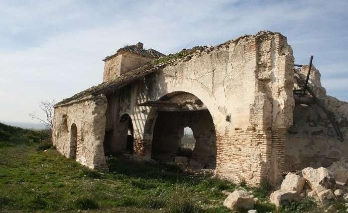
MOYA & PINTO, 2022

                                                                   Most of the counterweight towers have a hipped roof
                                                                   covered with ceramic tiles, and there is an odd case of
                                                                   a curved pitched roof and a flat roof22 (Table 8).
                                                                   For both the roof over the press and the roof over the
                                                                   counterweight tower we obtained the angle of inclination
                                                                   from the point cloud created for the Charcón mill,
                                                                   which we then verified at the different mills that
                                                                   display the same type and geometry of roof or their
                                                                   impressions. (Fig. 14).
                                                                   We then considered the results of all these building
                                                                   system parameters to define the dimensions of the
                                                                   elements that we were unable to obtain in situ.

Figure 13: Opening in the counterweight tower.at the Pino mill     4.3. Results obtained
       showing the wall thickness to be two stretchers.

                                                                   4.3.1. Non-dimensional elements
                                                                   Before presenting the data set obtained as a result of
                                                                   our research, we must mention three aspects we
                                                                   identified using digital models that have repercussions
                                                                   for the typological definition of the mill and are
                                                                   not associated with dimensional values. The first one is
                                                                   related to the orientation of the press and the openings
                                                                   in this structure (Table 9). The second aspect
                                                                   determines the position of the counterweight tower
                                                                   relative to the courtyard (Table 10). Lastly,
                                                                   we identified the number of arches in the wall that
                                                                   separates the grinding areas from the adjacent beam
                                                                   area (Table 11).

                                                                     Table 9: Orientation and windows in the press (Facade of the
                                                                                             beam area).
                                                                        Orientation    N     S       E     W         NE     NW   SE       SW
                                (a)                                     Mills (170)    16     5      8      7        37     70   14       20

                                                                        Openings              0                  1               2
                                                                         Mills (43)          38                  1               4

                                                                        Table 10: Position of the counterweight tower relative to the
                                                                                                 courtyard.
                                                                    Location of the tower relative       Right            Left   Right and
                                                                          to the courtyard                                          left
                                                                               Mills (178)                95              81          2

                                                                   4.3.2. Dimensional elements
                                (b)
                                                                   In this section, we present the results where the value is
      Figure 14: (a) Collar beam roof over the press and           associated with numerical data. We begin with the
 hipped roof at the Charcón mill; (b) impressions on the tower     dimensions of the press. As shown in Figure 15,
     at the Notario mill. We verified the angle of inclination     the length of the press varies between approximately 14
   as 30º for the pitches of the roofs of both the press (collar   and 34 m,23 with ranges of different dimensions obtained
       beam) and the counterweight tower (hipped roof).
                                                                   as a result of the length of the beam used, as in the case
                                                                   of the 18 m (22 varas), 20 m (24 varas), 22 m (27 varas)
  Table 8: Number of mills per variety of counterweight tower      and 24 m (29 varas) beams.
                             roof.
   Hipped roof    Curved pitched roof     Flat      Unknown
      116                   3              17          150

                                                                   22
Lastly, at all mills, the roof over the press is a pitched            The flat roofs have a more ornamental treatment. Herrera
structure, made of wood with a collar beam over                    (2002) describes this stylistic device as a distinction of the mills
the beam area and a mono-pitched structure as a                    from the late 18th and early 19th centuries.
                                                                   23
                                                                      According to Payo (1840), the dimension of the beam area
continuation of the roof over the beam area.
                                                                   “had to be only slightly less than the nave of a small church”.

Virtual Archaeology Review, 13(26): 116-134, 2022                                                                                         124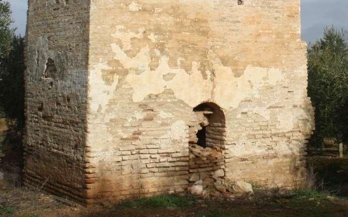
DIGITAL MODELS APPLIED TO THE TYPOLOGICAL ANALYSIS OF THE OLIVE OIL MILLS WITH BEAM
                                    AND WEIGHT PRESSES IN ÉCIJA

     Table 11: Number of arches between the beam area and
                         grinding area.

     Number of arches      024        1        2        325

        Mills (61)          3         4        53        1

In relation to the span or width of the press, there are
fewer variations since the value only fluctuates between
7.5 m and 9.75 m. This may be explained by the fact that
the activity at the mill was always carried out by
the same number of people, regardless of the length
of the beam
In the case of the width of the interior space, we                                             (a)
observed that the grinding area requires more space
(3-4.5 m) than the beam area (2.75-3.5 m) because the
latter was only accessed to activate the spindle,
situated at the end of this part of the mill. The height of
the press is significantly greater (5.5-7 m) than the
height of the grinding area, where the scale is on a more
human level (3-4 m), possibly because of the need to
raise the beam.
In the case of the counterweight tower we noticed that
the face of the wall that coincides with the length of
the area is shorter (3-4 m) relative to the face considered
to be the facade (4-5 m). There is a greater variety
                                                                                               (b)
of dimensions (6.5-11.5 m) as regards the height,
although most of the values are concentrated in the
7-5-9 m range (Fig. 16).
Lastly, we present the values related to the analysis of
the arches that separate the grinding and beam areas
(Fig. 17). In relation to the size of the arches, the span of
the one closest to the counterweight tower is always the
shortest (2.5-4 m), and we therefore consider this to be a
service arch.
The second arch, which had to be large enough to allow
the passage of the draught animals, presents similar
measurements (6-7.5 m) because the grindstone was
situated just below it (Fig. 18). The buttress on                                              (c)
which both arches rest varies between 1.3-2 m in
length and 2 stretcher bricks in width. Regarding the
height from the floor to the keystone of the arch, there
are significant variations in the dimensions, with this
central voussoir usually being higher in the second arch.
Lastly, in terms of the arch chord, the values of the first
arch are distinctly smaller (1.5-2.25 m) than those of the
second arch.

4.3.3. Analysis of the results
Although in some cases the results obtained allow us to
define a clear typological distinction for the mills, we can                                   (d)
establish the following dimensional relationships to
determine whether the mill variables bear any mutual                 Figure 15: Dimensions of the press obtained from digital
relationships. The set of relationships and their values                models. (a) Press length; (b) press width; (c) width;
are grouped in Table 12.                                                                 (d) press height.

24
                                                                  4.3.4. The geographic location of results
   In these cases, as at the Nuño mill, there are no arches
because the grinding process was carried out in an adjoining      With the results obtained, we then attempted to establish
space. A pre-existing farm was probably converted into a mill,    the possible existence of neighbourly relations between
as we know to be the case at El Nuño.                             the mills with common parameters. To do this, we
25
   Bundle 358 at the APNE specifies that if the third arch were   created a GIS model with a preliminary selection of the
to be blocked up, it should be with a rammed earth wall. This
instruction suggests that in some cases the arches were
                                                                  mills that share the same counterweight tower height
blocked up since they were no longer of use, which explains       and press length within a range of 0.5 m. Having
why they do not appear in mills built at a later date             identified the mills with these shared values (38 in total),

Virtual Archaeology Review, 13(26): 116-134, 2022                                                                           125
MOYA & PINTO, 2022
(a)
(a)
(b)
(b)
(c)
Figure 16: Dimensional values of the counterweight tower (a)
and (b) counterweight tower; (c) height of the counterweight (c)
tower.
Figure 17: (a) Arch spam; (b) height of keystone; (c) arch
chord. Dimensions of the arches between the grinding and
beam areas.
Figure 19: GIS site map of the relationship between mills with a
Figure 18: Location of the grindstone below the second arch. similar counterweight tower and press length. The colours
indicate mills where this is the case. The ones in blue also have
neighbourly relations in a radius of less than 2 km.
Virtual Archaeology Review, 13(26): 116-134, 2022 126DIGITAL MODELS APPLIED TO THE TYPOLOGICAL ANALYSIS OF THE OLIVE OIL MILLS WITH BEAM
AND WEIGHT PRESSES IN ÉCIJA
Table 12: Relationship between results.
Relationship between elements Value
Press length and width 1.5-3.25
Exterior press width and interior beam area 2.5-
3
Exterior press width and interior beam area 2.25-2.75
width
Press length and tower height 2-3.25
Tower volume and press length 4-
7.5
Tower thickness facing press 1.75-2.60
Tower thickness facing facade 1.5-
2
Exterior side facing facade and exterior side 1.1-1.4
facing press tower
Second arch span and first arch span 1.6-2.2
Arch span and height of first arch keystone 0.7-1.2 (a) (b)
Arch span and height of second arch 1.3-1.8
keystone
Arch span and first arch chord 1.5-2.3
Arch span and second arch chord 2-
2.4
First arch span and pillar between arches 1.5-3.25
Second arch span and pillar between 3.5-5.25
arches
Press length and first arch span 5-8
Press length and second arch span 2.75-3.75
Tower height and press ridge height 1.1-1.5
Beam height and first arch keystone height 1.18-1.78
Beam height and second arch keystone 1.14-1.38
(c) (d)
height
Tower height and first arch span 1.80-2.6 Figure 20: Mills that share press length and tower height
Tower height and second arch span 1.00-1.35 parameters within a radius of 1 km. The formal and stylistic
similarity is plain to see. (a) San José mill; (b) Patio grande mill;
(c) Ciprés mill; (d) Pino mill.
Figure 21: Parameters of mills located within a short distance of each other that share tower height and press length dimensions, based
on the colour coding used in Figure 18.
we established a radius of 2 km around the various mills 4.4. Application of the results on a 16th-
to check for typological similarities and neighbourly century mill
relations. Of the 28 studied, 24 meet the requirements of
relations with up to five mills (Figs. 19, 20 and 21). We conducted a case study to apply all the parameters
However, when we checked the other parameters, we analysed as a result of the data obtained. The model
were unable to quantify the mills where all the values are chosen is recorded in a document related to the
similar or approximate (20). construction of a press in 1574, namely the
Virtual Archaeology Review, 13(26): 116-134, 2022 127MOYA & PINTO, 2022
aforementioned Bundle 358 at the APNE. This document relationships of the ranges used to define this criterion
contains a description of the construction process26 as are shown in grey.
well as a plan for the mill (Fig. 22) with dimensional
values for the spaces and a graphical scale in Castilian
varas. These aspects and the existence of notes about Table 14: Known and deduced relationships between elements
in the 16th-century mill.
dimensional values for the construction works enabled
us to map the mill (Table 13). Elements Mill value Value
1574 according to
For this case study, we only defined the space Table 11
corresponding to the press.
Press length and tower height 2.98 2-3.25
Table 13: Values obtained from the 1574 plan and transcription
of the text on the construction of the press. Source: APNE. Press length and width 3.04 1.5-3.25
Element Identification of value
Tower volume and press length 4-7.5
Tower relative to the courtyard Left
Opening in press 1 door Exterior press width and interior 2.65 2.5-3
beam area
Exterior length 24.17 m
Exterior press width and interior 2.60 2.25-2.75
Interior length 24 varas (20.06m) beam area
Press width 7.95 m Tower thickness facing press 2 1.75-2.60
Beam area width 3m
Tower thickness facing facade 1.89 1.5-2
Grinding area width 3.05 m
Brick stem wall 1 vara (0.8359m)27 Exterior side facing facade and 1.06 1.1-1.4
exterior side facing tower
Press walls width 2 bricks (0.64m)28
Second arch span and first arch 2 1.6-2.2
Beam area height 6 rammed earth modules +
span
1-vara stem wall (5.87m)29
First arch span and pillar between 2 1.5-3.25
Small arch span 4 varas (3.343m)
arches
Large arch span 8 varas (6.687m)
Second arch span and pillar 4 3.5-5.25
Pillar between arches 2 varas (1.67m) between arches
Exterior tower sidewall 4.04m Press length and first arch span 7.23 5-8
Exterior tower facade 4.28m
Press length and second arch span 3.56 2.75-3.75
Press ridge height 7.3930
Counterweight tower roof Hipped31 Tower height and press ridge 1.09 1.1-1.5
height
Tower height and first arch span 2.42 1.80-2.6
We identified numerous parameters for the mill, although
we do not know the values for the height of the Tower height and second arch 1.21 1.00-1.35
counterweight tower or the height of the keystones on span
the arches between the different areas. Table 14 shows
the parameters of the elements for which we know the The results obtained are shown in Figure 23.
values, either from the plan or the transcription of the
document, as well as those we obtained (in red) by
deducing the tower height.
To deduce the height of the counterweight tower,
we analysed the relationship between the results
obtained in the previous sections, while for the height of
the arches we were only able to establish a range of
values between a maximum and a minimum. The
26
These bundles were transcribed and published in Écija
Artística. Colección Documental, siglos XVI y XVII (León &
Martín, 2018).
27
...that raises the foundation one vara all round... (Bundle
358).
28
…that forms walls of two bricks all round (Bundle 358).
29
...with six rammed earth walls to raise the height of the beam
area in the mill... (Bundle 358).
30
This value is obtained by assuming an angle of 30º and a
collar beam roof Figure 22: Map accompanying Bundle 358 related to the
31
…the truss in the tower and cover with terracotta tiles… construction of a press in 1574. Source: APNE.
(Bundle 358).
Virtual Archaeology Review, 13(26): 116-134, 2022 128DIGITAL MODELS APPLIED TO THE TYPOLOGICAL ANALYSIS OF THE OLIVE OIL MILLS WITH BEAM
AND WEIGHT PRESSES IN ÉCIJA
The combination with the most restricted range of values
corresponds to the relationship between the ridge and
the tower height. From these data, we can deduce that
the tower measured between 8.12 m and 8.45 m.
Meanwhile, based on the thickness of the facade side,
the maximum height of the tower would be 8.08 m, so by
combining these results we estimate the tower to have
been 8.10 m high.
We now propose a new hypothesis for the values of the
keystone height and the chord of the arches separating
the different areas based on the relationships specified
in Table 13. In this case, the spectrum of results is wider,
with the result that the first arch would have a height of
between 3.35-4.77 m and the second arch between Figure 24: Ranges of values of the arches between the areas.
4.25-5.13 m. The chord for the first arch would measure
between 1.45-2.20 m and for the second arch between 5. Standard mill HBIM
2.78-3.34 m (Table 15 and Fig. 24).
Using the results compiled and their relationships of
dimensional proportionality, we generated the HBIM for
a standard mill. This geometric model is based on
parameterizable families defined according to the
typological elements of the press associated with a set
of alphanumeric records (Table 16). The initial
development corresponds to a basic level of knowledge
(LOK) about the mills (LOK 100), which is sufficient to
differentiate them according to typological elements.
The development of the base HBIM generated for the
Charcón mill is shown below. Since we have a 3D point
cloud for this mill, and therefore all the values, we were
able to define it completely. Having created the
standard model at a development level of LOK 100 (Fig.
25), we conducted a test for this specific case up to a
level of LOK 200 (Fig. 26), since this is the level that
provides a graphical characterisation and sufficient
information to carry out the actions related to the legal
protection of the asset and its strategic planning
(Castellano, 2017). Besides, the LOK 200 could be
Figure 23: Ranges of values for the counterweight tower.
incorporated by connecting new external databases
(Achile, C., Fassi, F., Mandelli, A., Perfetti, L., Rechichi,
F, & Teruggi, S., 2020): materials, ornamentation, type
of rammed earth, etc.
Table 15: Deduced values for the keystone height and chord of
the arches based on relationships.
Table 16: Families that constitute the HBIM.
Keystone height
Zone Code Parameter (m)
Elements Maximum Minimum Grinding NM01 Height of courtyard facade exterior
value value area wall
NM02 Maximum height of facade side
Arch span and height of first arch 4.77 2.78 NM03 Length of facade side wall
keystone
NM04 Length of area side wall
Arch span and height of second arch 5.13 3.71 NM05 Interior width of area
keystone NM06 Exterior width
Beam NV01 Height of exterior wall
Beam area height and first arch 4.97 3.35 area NV02 Height of ridge
keystone height
NV03 Length of wall preceding arches
Beam area height and second arch 5.14 4.25 NV04 Arch span 1
keystone height NV05 Arch span 2
NV06 Height of arch keystone 1
Height of keystone 1 and pillar 5.01 3.01 NV07 Height of arch keystone 2
between arches
NV08 Arch chord 1
Height of keystone 2 and pillar 5.55 4.12 NV09 Arch chord 2
between arches NV10 Width of pillar between arches
NV11 Interior width of area
Arch span and first arch chord 2.22 1.45 NV12 Interior length of area
Arch span and second arch Chord 2.78 3.34 NV13 Exterior length of area
Tower T01 Height
T02 Width of facade side
T03 Width of area side
T04 Interior width of tower facade
T05 Interior width of area side
Virtual Archaeology Review, 13(26): 116-134, 2022 129MOYA & PINTO, 2022
6. Discussion
To date, the most complete contribution to our
knowledge of the Écija mills is the publication Cortijos
haciendas y lagares Cortijos, haciendas y lagares:
arquitectura de las grandes explotaciones agrarias de
Andalucía (Granados, 2009), which contains a register
of these structures (approximately half of the mills
identified in this article). On this list, the mills with high
interest (three mills) and some of the mills with a
medium interest (12 mills) include the floor plan,
(a) (b) whereas all the other mills are only accompanied by a
brief description and a photograph. Other publications
referenced here also shed important light on the Écija
mills, most notably the one by García-Dils et al. (2006),
which discusses the general structure and organisation
of the mills and includes the original floor plan of a 19th-
century mill. Equally important is López (2012)’s detailed
description of the press at the Puntales mill in Écija.
Outside Écija, significant contributions have been made
by more generic publications on mills (Delgado, 2012),
as well as others of a more specific nature, such as the
(c) publication by García, Muñoz & Sánchez (2006) on a
press in Murcia and the ones on olive haciendas in
Seville (Nuñez, 2016; Infante, 2014; Recio, 2003, 2005).
Despite the importance of all these publications, there is
no study of Écija mills that compares and contrasts their
different scales. The methodological approach adopted
in this article, based on the typological distinction of the
mills according to architectural and building aspects, can
therefore contribute crucial information for our
knowledge of these structures in rural Écija. We also
analyse the use of traditional building systems applied to
(d) constructions belonging to our agro-industrial heritage,
Figure 25: Volumes with parameterisable elements from the as in the case of rammed earth walls, which have
HBIM: (a) west-facing; (b) volume 3D; (c) south-facing; and hitherto received relatively little attention compared with
(d) section of the beam area. Grinding area in blue, beam area their use in other fields, such as military architecture, as
in yellow and counterweight tower in red. evidenced by the research of Canivell, Rodríguez,
González, & Romero (2020), Gil & Maldonado (2015),
and Mileto, Vegas, & García (2013).
Besides, the use of different digital tools has
demonstrated their versatility for generating heritage
knowledge, a topic which has been amply explored by
Angulo, (2020), Jordan, Tzortzopoulos, García-
Valldecabres, & Pellicer (2018), Pocobelli, Boehm,
Bryan, Still, & Grau-Bové (2018); this prevents overly
reductionist approaches limited to a specific discipline.
Lastly, the case study of the 16th-century mill, the
existence of which was known solely by León & Martín
(a) (2018), has not only shed new light on this extraordinary
document but has demonstrated, through direct
application, the suitability of the proposed methodology.
7. Conclusions
The typological study of the mills reveals a unity
between nearly all the cases analysed in terms of the
spaces that define the press (beam area, grinding area
and counterweight tower). However, the parameters
corresponding to their geometry vary between mills,
although there are relationships of proportionality. These
relationships enable us to define ranges of dimensional
values for each element, and this interrelationship
(b) makes it possible to obtain the measurements for the
constituent parts of lost or unknown mills, as in the case
Figure 26: 3D volume of the HBIM LOK 200: (a) Interior space of the mill built in the 16th-century.
beam area; and (b) Exterior space beam area. These images
show the building systems.
Virtual Archaeology Review, 13(26): 116-134, 2022 130DIGITAL MODELS APPLIED TO THE TYPOLOGICAL ANALYSIS OF THE OLIVE OIL MILLS WITH BEAM
AND WEIGHT PRESSES IN ÉCIJA
The correspondence in the relationships of supply the values that could not be obtained during the
proportionality between the mills analysed typologically field trips and can incorporate new records related to a
and the 16th-century mill suggests that 18th-century mills higher level of knowledge about the mills, such as their
were adapted to patterns developed in older presses. damages, alterations and pathological state.
The building systems determine some of the
morphological aspects of the mills; for example, brick Acknowledgements
measurements and rammed earth modules determine
the geometric values of the mill and therefore the This article forms part of the results of Research Project
typological definition. HAR2016-78113-R, funded by the Ministry of Science,
Innovation and Universities. European Social Fund. It
The creation of an HBIM is useful because of the was also made possible thanks to the availability and
existence of a considerable number of mills where it is advice of Marina Martín Ojeda (Écija Municipal Archive),
easy to delimit the parameterisation of the families. The the generosity of Sergio García-Dils and Valle García
creation of a standard 3D graphical base, applicable to (Écija Town Council), and the invaluable assistance of
the analysis of any mill using HBIM, represents an Alberto Atanasio, Eduardo Acosta, Ana González, Luisa
efficient and accessible tool for any heritage agent since Martos, Raquel Ramiro and, in particular, Eva Simón
it is structured on a simple database. The HBIM offers a and Javier Moya.
dynamic management model because it may be used to
References
Achile, C., Fassi, F., Mandelli, A., Perfetti, L., Rechichi, F, & Teruggi, S. (2020). From a traditional to a digital site:2008-
2019. The history of Milan Cathedral Survey. In B. Daniotti, M. Gianinetto, & S. Della Torre (Eds.), Digital
Transformation of the Design, Construction and Management Processes of the Built Environment, 331-341.
https://doi.org/10.1007/978-3-030-33570-0_30
Angulo Fornos, R. (2020). Desarrollo de modelos digitales de información como base para el conocimiento, la
intervención y la gestión en el patrimonio arquitectónico: de la captura digital al modelo HBIM [Development of digital
information models as a basis for knowledge, intervention and management in architectural heritage. From digital
capture to the HBIM model] (Doctoral thesis. Seville University, Spain). https://idus.us.es/handle/11441/98088
Canivell, J., Rodríguez García, R., González Serrano, A., & Romero Girón, A. (2020). Assessment of Heritage Rammed-
Earth Buildings: Alcázar of King Don Pedro I, Spain. Journal of Architectural Engineering, 26(2), 05020003.
https://doi.org/10.1061/(ASCE)AE.1943-5568.0000400
Carapellese, G., Canivell, J., Martín-del-Río, J. J., Graciani-García, A., & Cabrera-Revuelta, E. (2020). Evaluación de
fortificaciones rurales de tapia mediante técnica SfM de fotogrametría digital. Aplicación metodológica al Castillo de
Alhonoz (Écija, España). Estoa, 9(18), 164-182. https://doi.org/10.18537/est.v009.n018.a09.
Castellano Román, M. (2017). La Cartuja de Nuestra Señora de la Defensión en Jerez de la Frontera: un modelo digital
de información para la tutela de bienes inmuebles del patrimonio cultural [The Charterhouse of Nuestra Señora de la
Defensión in Jerez de la Frontera: a digital information model oriented towards the management of cultural inmovable
heritage assets] (Doctoral thesis. Sevilla University, Spain). https://idus.us.es/handle/11441/65027.
D.A.G. & D.M.C (1865). Manual o anuario ecijano, dedicado a sus convecinos. Écija. Imprenta de D.A. Pereyra. Archivo
Municipal de Écija (AME). Obras y Urbanismo. Legajo 167/46.
Decree 1010/1972 of 13 April 1972 on the conversion and restructuring of olive production Official Spanish Gazette
(BOE), 98, of 24 April 1972, p. 7228. Spain, Department of Agriculture.
Digital Catalogue of Historical Cartography. (1910-1925). Statistical and Cartographic Institute of Andalusia. Trabajos
Topográficos de la provincia de Sevilla. Ayuntamiento de Écija.
Digital Catalogue of Historical Cartography. (1951-1958). Statistical and Cartographic Institute of Andalusia. National
Topographic Plot Map. Province of Seville. Legal Jurisdiction of Ecija. Municipality of Ecija. Area 1-87. 1:5000 scale.
Instituto Geográfico y Catastral.
Écija Town Council. (2009). Plan General de Ordenación Urbana de Écija. Inventario de Bienes Protegidos, tomo I.
Écija Town Council. (2009). Plan General de Ordenación Urbana de Écija. Normas Urbanísticas y Ordenanzas.
Écija Town Council. Municipal Archive (AME). Leg. 358. ff 409r-414v. Reforma de una almazara. (1574).
Garay y Conde, J. M. (1851). Breves apuntes histórico-descriptivos de la ciudad de Écija. Écija: Imprenta M. Salgado y
Trigos.
García Blánquez, L. A., Muñoz Clares, M., & Sánchez Pravia, J. A. (2006). Una prensa de viga y quintal con torre
contrapeso en Librilla. Una almazara de Hacienda de Olivar en Murcia. Revista Murciana de Antropología, 13, 159-
183.
Virtual Archaeology Review, 13(26): 116-134, 2022 131You can also read