AB 2911 improves the fire safety of communities
in high fire risk severity zones
Subdivision Review Program
←
→
Page content transcription
If your browser does not render page correctly, please read the page content below

AB 2911 improves the fire safety of communities in high fire risk severity zones Subdivision Review Program
CAL FIRE

         Subdivision Review Program Mission

To identify existing subdivisions located in the State
Responsibility Area (SRA) or a Very High Fire Hazard
Severity Zone identified pursuant to GC 51178, without a
secondary means of egress route that are at significant
fire risk. And provide recommendations in creating a
secondary access to the subdivision, improvements to
existing access roads, and other fire safety measures.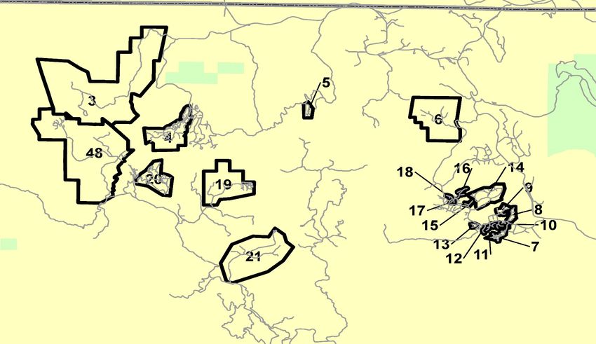
Safety Element Compliance with SB 1241

Today’s topics of discussion:

1. AB 2911, PRC 4290.5, and new article 1267.01 of CCR
  • Who, When, What, How
2. Improve fire safety in California’s communities
3. Useful Resources
About Us

Land Use Planning

                                            Mike Richwine
                                          State Fire Marshal
                                              Daniel Berlant
                                        Assistant Deputy Director
                                        Planning and Risk Analysis
                                                Steve Hawks
                                                 Staff Chief
                                      Wildfire Planning & Engineering

    Scott Witt      Matt Damon               Frank Bigelow                   Natalie Burke       Lynne Tolmachoff
   Deputy Chief     Deputy Chief              Deputy Chief              Staff Services Manager        DSFM III
     Fire Plan    Land Use Planning       Wildfire Prevent Eng.         Fire Prevention Grants    CalStats (CAIRS)

                                      Land Use Planning
                                          Program

                                         Subdivision
                                       Review Program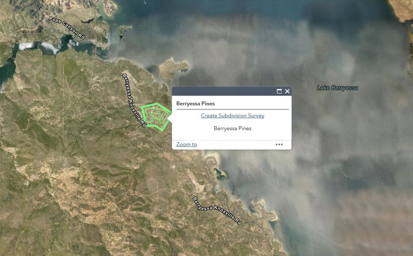
Fire Hazard Planning - The Big Picture

Emergency Management

                      The goal of fire hazard planning is to
                    reduce the impact of wildland fire in the
     PLANNING        short, near, medium and long term by
                   looking beyond jurisdictional boundaries.
AB 2911 (Friedman 2018)
Subdivision Review Program
Assembly Bill 2911 (Friedman 2018)

Where did this all come from?

“One of the key areas that is our responsibility to take a hard
 look at is wildfire prevention, as well as recovery from fires.
As one of the many consequences of climate change, we are
seeing precipitation levels alter dramatically from historical
trends. With that, the lands that are home to communities throughout
California are at a rapidly increasing risk of severe, disaster-level, fires. From
Butte County to the hills of our district, to the forests and mountains
surrounding Redding and Santa Rosa, we have already seen devastation.” –
said Friedman

Assembly Bill 2911 (Friedman 2018)

                                    2017 Fire History
Redwood Valley Fire – Mendocino County         Tubbs Fire – Napa & Sonoma County
•  36,523 acres                                •   36,807 acres
•  546 structures destroyed                    •   5,636 structures destroyed
•  9 deaths                                    •   22 deaths

Atlas Fire – Napa & Solano County              Thomas Fire - Ventura & Santa Barbara County
•   51,624 acres                               •  281,893 acres
•   783 structures destroyed                   •  1,063 structures destroyed
•   6 deaths                                   •  2 deaths

Nuns Fire – Napa & Sonoma County
•  54,382 acres
•  1,355 structures destroyed
•  3 deaths
Assembly Bill 2911 (Friedman 2018)
Section 4290.5 is added to the Public Resource Code:
4290.5. (a) On or before July 1, 2021, and every five years thereafter, the board, in consultation with the State
Fire Marshal, shall survey local governments, including counties, cities, and fire districts to identify existing
subdivisions located in a state responsibility area or a very high fire hazard severity zone, identified pursuant
to Section 51178 of the Government Code, without a secondary egress route that are at significant fire risk.

(b) (1) The board, in consultation with the State Fire Marshal and the local government that identified the
subdivision, shall develop recommendations to improve the subdivision’s fire safety. The recommendations
may include, but are not limited to, the following:

     (A) Creating secondary access to the subdivision.
     (B) Improvements to the existing access road.
     (C) Other additional fire safety measures.

(2) The board shall provide the final recommendations developed pursuant to this subdivision to the local
government that identified the subdivision and to the residents of the subdivision.
(c) The board may enter into contracts with an independent group to
conduct the survey required in subdivision (a).
(d) For purposes of this section, “subdivision” means an existing residential development of more than 30
dwelling units.
(e) The board shall maintain a list of the subdivisions identified in subdivision (a) and the status of the
implementation of the recommendations provided pursuant to subdivision (b).
Fire Safety Survey
Title 14 of the CCR § 1267.00 – 1267.03
Fire Safety Survey
14 CCR § 1267.00 Definitions
(a) The following definitions apply to Title 14 of the California Code of Regulations (14 CCR), Division 1.5,
Chapter 7, Subchapter 1, Article 2.

Dwelling unit: A “dwelling unit” has the same definition as a “residential unit” below.

Local responsibility area (LRA): Those areas of land classified by the Board of Forestry and Fire Protection
(Board) where the financial responsibility of preventing and suppressing wildfires is not that of the state or
federal government, pursuant to Public Resources Code (PRC) 4125.

Residential unit: Any building or portion thereof which contains living facilities, including provisions for
sleeping, eating, cooking and/or sanitation, for one or more persons. Manufactured homes, mobilehomes, and
factory-built housing are considered residential units (14 CCR § 1271.00).

Road: Any surface designed, improved, or ordinarily used for vehicle travel. Includes public and private streets
and lanes.

State Responsibility Area (SRA): as defined in Public Resources Code 4102.

Subdivision: an existing development of more than thirty (30) residential units, not necessarily subdivided as
defined in Government Code 66424.

Very high fire hazard severity zone (VHFHSZ): as defined in Government Code 51177(i) and identified pursuant
to Government Code 51178.
Fire Safety Survey
14 CCR § 1267.01 Fire Safety Survey
(a) On or before July 1, 2021, and every five years thereafter, the board, in consultation with the State Fire
Marshal, shall survey local governments, including counties, cities, and fire districts, to identify existing
subdivisions without an adequate secondary egress route in all SRA or LRA mapped as a very high fire hazard
severity zone.

     (i) An adequate secondary egress route is a road, navigable by a passenger vehicle weighing 6,000 pounds
     or less, of equal construction standard to the primary road. The secondary road does not have to be rated to
     carry the same quantity of traffic (e.g., a two-lane paved road and a one-lane paved road is acceptable).

     (ii) An adequate secondary egress route is not:
     (A) a road with locked gates or limited access; or
     (B) a road that directs traffic to the same outlet road as the primary road or results in a circular traffic flow,
     to the extent practicable.

(b) Local government officials, including elected officials, fire officials, or representatives of agencies that govern
land use planning and subdivision design, may request the board and the State Fire Marshal survey specific
subdivisions in their jurisdiction.
Fire Safety Survey 14 CCR § 1267.02 (a) The Board, in consultation with the State Fire Marshal and the local government that identified the subdivision, shall develop recommendations to improve the subdivision's fire safety. (b) The Board shall provide the final recommendations developed pursuant to § 1267.03(a) to the local government that identified the subdivision and to the residents of the subdivision.
Fire Safety Survey
14 CCR § 1267.03
(a) The Board shall maintain a list of the subdivisions identified in § 1267.01.

(b) The Board shall track the status of the implementation of the recommendations provided pursuant to § 1267.02.
Conducting Subdivision Review Surveys
Research and Recommendations Process
Conducting Subdivision Review Surveys
Community Wildfire
Local/State Hazard Unit Fire Plan & Firewise USA
Protection Plans
Mitigation Plans (HMP) State Strategic Plan Risk Assessment
(CWPP)
Safety Element Subdivision Review FRAP Maps
(General Plan) Survey and Research (LRA and SRA)
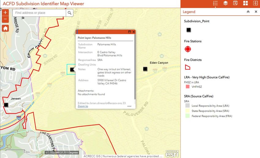
Subdivision Survey Observations
• Access points
• Open space areas
• Fuel modifications
• PRC 4290 standards
• Building construction
• Defensible spaceConducting Subdivision Review Surveys Survey Priority List • Significant fire incidents • Fire history (1970-2019) • Firewise USA sites • Communities at Risk • Local Hazard Mitigation Plan (approval and adoption date) • Safety Element (review and submittal to the Board date) Research resources • California Department of Real Estate • Local jurisdiction GIS Coordinator • Local Fire Marshal and/or Fire Protection Agency • Planning Department • Building Department Data collection tools • ArcGIS Collector • ArcGIS Survey 123 • ArcGIS Quick Capture • Record and maintain Subdivision list
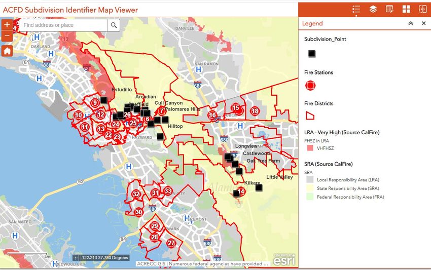
Conducting Subdivision Review Surveys
Conducting Subdivision Review Surveys
Conducting Subdivision Review Surveys
Conducting Subdivision Review Surveys

ArcGIS Collector
Conducting Subdivision Review Surveys

ArcGIS Survey 123
Conducting Subdivision Review Surveys

ArcGIS Survey 123
Conducting Subdivision Review Surveys

Survey Report
Conducting Subdivision Review Surveys

Recommendation Report
Conducting Subdivision Review Surveys

ArcGIS QuickCapture
Current Situation
Current Situation
Current Situation
Conclusion

  Thank you…questions?
              Please contact our Subdivision Review Program:
       Deputy Chief Matt Damon, Matt.Damon@fire.ca.gov , (916) 247-1156

  Assistant Chief Carmel Barnhart, Carmel.Barnhart@fire.ca.gov , (916) 208-0043

        Battalion Chief Jeff Hakala, Jeff.Hakala@fire.ca.gov , (916) 201-2732

    Battalion Chief Rudy Baltazar, Rudy.Baltazar@fire.ca.gov, (916) 809-2909

Office Technician Melinda Pritchard, Melinda.Pritchard@fire.ca.gov , (916) 568-3812
You can also read