2021 Florida Historical Society
←
→
Page content transcription
If your browser does not render page correctly, please read the page content below
Indigenous    Florida Panhandle   Tomoka
        Northeastern Florida     Shipwreck Trail   Archaeology Project

                                                        2021
IN FLORIDA ARCHAEOLOGY

Saving Angola
Community-based
Archaeology as
Grassroots Activism

            FLORIDA HISTORICAL SOCIETY ARCHAEOLOGICAL INSTITUTE
EDITORS’ NOTE ON THE COVER
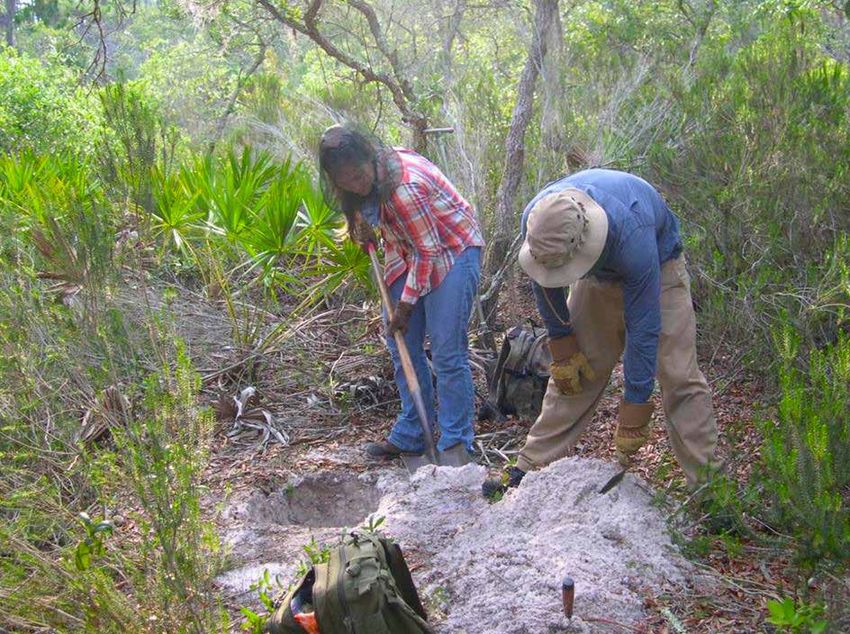
A barrel well was among the important features
uncovered during excavation of the Angola
site in Bradenton. Once cleared of soil, water
seeped into the well as it had in the past,
TABLE OF
reflecting the image of a modern archaeologist.
Courtesy of Sherry Robinson Svekis CONTENTS
BACK COVER
02 INDIGENOUS
NOAA archaeologists record two shipwreck
sites in the Florida Keys National Marine
Sanctuary. Courtesy of Brenda Altmeier (top) NORTHEASTERN FLORIDA
and Matt Lawrence (bottom) Searching for a Mocama Indian Community
ANNE V. STOKES, PH.D. KC SMITH 08 FROM PALEO-INDIAN
TO PROTOHISTORIC
FLORIDA HISTORICAL SOCIETY BOARD FLORIDA HISTORICAL SOCIETY St. Vincent Island’s Enduring
OF DIRECTORS AND CEO OF SEARCH BOARD OF DIRECTORS
Native Occupation
A s with everything in the past year, the covid pandemic Digital History Project highlighted by KC Smith is a wonderful
upended archaeological research. Field schools were
cancelled or postponed; contract firms worked on fewer
infrastructure projects; and research-related travel came
resource for researchers.
Fred Gaske’s article illustrates how a seemingly unimportant
14 FLORIDA PANHANDLE
SHIPWRECK TRAIL
to a halt. However, while archaeologists worldwide groused artifact can tell a rich story and add new interpretation to a A Bridge between the Archaeological
about the pandemic’s effects, the pause in field studies site. It also illustrates the importance of context within history and Artificial
actually allowed folks to catch up on lab work, think about and archaeology. The stencil plate’s significance would have
new ways to interpret data, and delve further into the link been lost had it been found on a roadside. Through context,
between history and archaeology.
In the fifty-plus years since Ivor Noël Hume proposed that
Jon Endonino used excavated artifacts and ecofacts to
propose a St. Johns River Valley origin for the Tomoka mound
builders more than 50 km away.
22 DEEP DIVE INTO MARITIME
HERITAGE
“Archaeology is the handmaiden of history”—subsequently Archaeological and Historical Resources
a much-debated concept within both disciplines, we have Endonino also notes the changing environments that pre- in Florida
come to realize that archaeology and history go hand in contact and protohistoric populations experienced as sea
hand. Archaeology makes history more tangible and reveals level rise altered food resources and required inhabitants to
that literary and popular notions of historic events can
be misleading. As Uzi Baram notes in his article about the
Angola site, “History is written by the winners.” Archaeology
adapt. The effect of sea level rise and other natural forces
on archaeological remains also is shown at Clint’s Scallop
Hole, a 3,000-year-old site that is four miles offshore. The
28 THE DOWNES & CO.
STENCIL PLATE
can support or refute historic documents. Even if the records work there by Morgan Smith and Shawn Joy reconfirms that A Small Artifact with a Big History
are accurate, we only get the big picture, not the details. the state’s submerged cultural heritage must be documented
Archaeology supplies the context and the details. and protected. Nancy White’s research on St. Vincent Island
32 SAVING ANGOLA
on Paleo to late prehistoric sites—which also reflect sea-
Keith Ashley used Laudonnière’s words to design a strategy to level change—additionally reminds us that offhand historical
locate and interpret the Mocama town of Sarabay. He notes comments, as were made when Narváez and crew stopped to Community-based Archaeology as
that, “Combining archaeology and historiography allows “steal Indian canoes and food,” enhance our archaeological Grassroots Activism
for a more nuanced reframing of conventional historical interpretations.
narratives based mostly on uncritical readings of biased
and static descriptions and observations of Native peoples
written by European chroniclers.” Melissa Price reminds
us that maritime heritage trails in Florida inspire modern
We thank the researchers who contributed to this issue and
everyone who protects, curates, and interprets our state’s
irreplaceable cultural heritage. We hope you enjoy this issue
42 CLINT’S SCALLOP HOLE
A Prehistoric Quarry in Apalachee Bay
explorers to learn about and protect our precious history—a of the magazine.
lesson that also applies to terrestrial sites. The Gulf Coast
48 TOMOKA
PROJECT
ARCHAEOLOGY
SHARE YOUR RESEARCH AND PROJECTS IN Adventures in Florida Archaeology Migration, Mounds, Tradition, and Change
We welcome feature articles and regional news that focus on academic research, CRM projects, new technologies,
artifacts, historic sites and museums, and other aspects of archaeological study. Abstracts for proposed articles are
due by November 15; finished articles and images are due by January 15. For information and submission details, Graphic design by
contact coeditors Dr. Anne Stokes, anne@searchinc.com, or KC Smith, kcsmith614@hotmail.com. Charity Myers, The Creative Pool Design, Tallahassee
Produced by Palm Springs Printing, Sanford
2021 Adventures in Florida Archaeology 1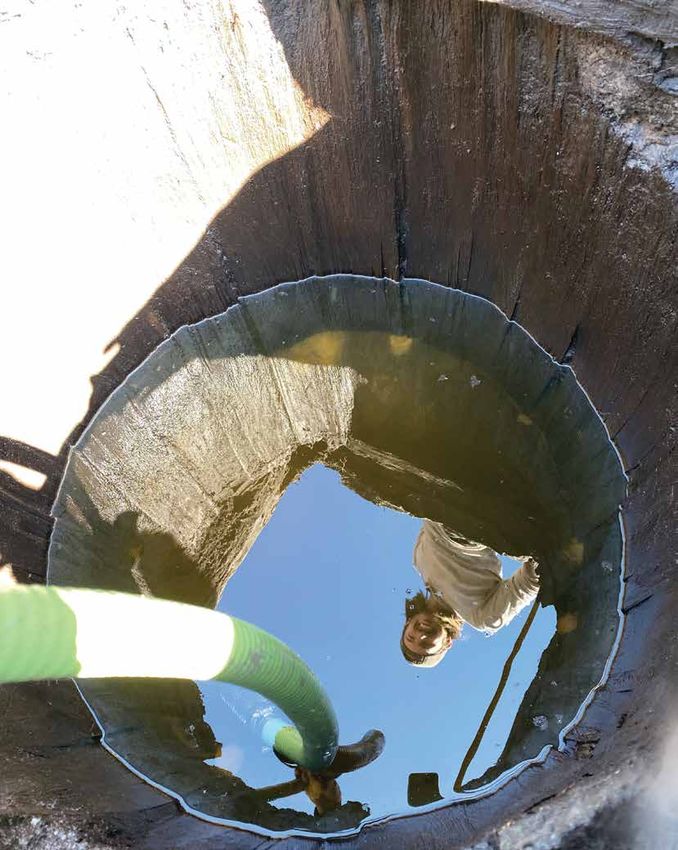
INDIGENOUS Keith Ashley
NORTHEASTERN LEFT: Titled “Castillo and proximities of Pilijiriba,
1703,” this map depicts “Isla de Sarabay” (Sarabay
FLORIDA
Island). Courtesy of the University of Florida Digital
Collections, George A. Smathers Libraries
Searching for a Mocama FAR LEFT: Rob Hough created this artistic
Indian Community interpretation of a Mocama Town for a Timucua-
Mocama art contest sponsored by the Public Trust
Environmental Legal Institute of Florida in 2010.
Courtesy of Warren Andersen
during the 17th-century, Mocama pottery production
underwent a shift from San Pedro to San Marcos wares.
But why is a question we still have not fully answered.
Following on the heels of our survey, Buzz, Vicki, and
I returned to the Armellino site along with students
from the University of North Florida (UNF). The 1998
UNF field school began with the excavation of four
scattered 1 x 2-m units, each placed adjacent to a
shovel test that had yielded either large numbers of
artifacts or possible subsurface features. The first three
units produced modest quantities of broken pots, oyster
Pareja wrote that Sarabay was one-quarter of a league shells, and animal bones, but not much else. However,
from San Juan. This is the last known archival reference the fourth unit captured our attention for the remainder
to the Mocama town, but the name Sarabay survives
on some maps to denote the island known today as
Big Talbot.
But exactly where is Sarabay on the modern landscape
T
of northeastern Florida?
hese brief passages, penned in 1564 by René
Laudonnière, signal the earliest known written That was the question I and my colleagues Buzz Thunen
“I was advised by some of our company, references to the Mocama (Timucua) town of Sarabay. and Vicki Rolland posed in 1998, as we initiated a shovel
who regularly went hunting in the woods The French commander of the La Caroline (Fort Caroline) test survey of the south end of Big Talbot Island. As
colony goes on to identify “King Saranay” (Sarabay) as early as the late 1960s, local avocational archaeologist
near the villages, that in the village of among other Mocama leaders who visited Jean Ribault William Jones had suggested Sarabay was located
Saranai [Sarabay], situated two leagues and presented “him with presents according to their there after finding “Indian pottery” and a piece of
from our fort [Caroline] on the other side custom” on his 1565 return to Florida.3 Three years majolica on the surface of a dirt road. Today, this area is
before, Ribault had briefly reconnoitered the entrance known as the Armellino site, and it lies mostly within Big
of the [St. Johns] river…there were fields of
to the St. Johns River and met with Indians on both Talbot Island State Park.
ripened grain in a very abundant crop”1 sides of the river, before heading north to establish the
garrison of Charlesfort on present-day Parris Island, Moving through dense forest in 1998, we dug more than
“…the village of Sarravahi [Sarabay]…was South Carolina. 550 shovel tests over a three-month period. Those on
the Armellino site stood out because many contained
about a league and a half from our fort The French La Caroline settlement, established near the Indigenous San Pedro and San Marcos pottery. It
[Caroline] and on an arm of the [St. Johns] mouth of the St. Johns River, lasted only fifteen months, was around this time that archaeologists working in
river. It had been my custom to send them being supplanted by the Spanish in 1565 after a rather northeastern Florida began equating the recently
[colonists] there each day to get clay for bloody eviction. Mentions of Sarabay in the Spanish defined, grog-tempered San Pedro ware with the 16th-
documents of La Florida are sparse, but we know the century Mocama-speaking Timucua of northeastern
brick and mortar for our houses”2 community rested less than a mile from the Fort George Florida and southeastern Georgia. San Marcos, on the
Island Mocama town of Alimacani and mission San Juan ABOVE: Features revealed in Block A in 1999 included a
other hand, has long been affiliated with the contact
wall trench structure in the southwest section, view to north.
del Puerto, where it fell under the ministering circuit of and mission-period Guale Indians of coastal Georgia. Courtesy of UNF Archaeology Lab
Fray Francisco Pareja. In a letter to the crown in 1602, However, more recent research now shows that
2 2021 Adventures in Florida Archaeology 2021 Adventures in Florida Archaeology 3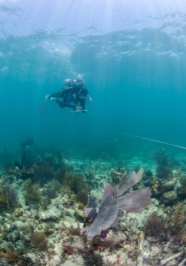
RIGHT: UNF field school
students Ejvind Sorensen,
Sarah Parker, Ian King, and
Rodney Collazo excavate
in Block C in 2021, view to
the west. Courtesy of UNF
Archaeology Lab
BELOW: The 1998
excavation of Block A
yielded a fragment of
a Native-made, incised
effigy tobacco pipe bowl.
According to archaeologist
Dennis Blanton, it
LEFT: Although the pot previously had been damaged by plowing, a San
represents a Citico-style
Marcos jar with a giant Atlantic cockle inside was among the exciting
pipe with a face and bared
finds in Block A in 1998. Courtesy of UNF Archaeology Lab
teeth (ear is depicted).
Courtesy of Robert Thunen
ABOVE: A postmold (foreground) and a pit (background) were among
the features revealed in the east wall of Block A in 1998. Courtesy of UNF
Archaeology Lab
of the summer and continued to do so into the following Along the inside wall of the building, about 10 cm No clay plaster or daub was
summer (1999). What began as a shovel test with a from the shovel test that led to block excavations, we associated with the wall
small soil discoloration, over the course of two summers, encountered a nearly complete San Marcos jar with trench structure, which
became a large excavation block (A-B) consisting of cane punctations along its rim. I shudder to think what appeared to be an unusual building tip, likely of Spanish origin. Whether
twenty-three 1 x 2-m units covering an 8 x 7-m area. would have happened to the pot if we had placed our technique for the Indigenous peoples these were acquired via trade or gift
shovel test just a few centimeters to the south. Inside the of northeastern Florida. However, exchange is unknown, but what is
Considering both the 1998 and 1999 field seasons, vessel was a complete giant Atlantic cockle shell with a structural evidence on Mocama clear is that the area we excavated
an impressive collection of artifacts and features was small square perforation. sites is sparse or indirect, typically postdates 1562. The scabbard piece
excavated. Of note was that small stain in a shovel test, consisting of individual postmolds of and olive jar sherds further imply a
which through expanded excavations, proved to be a The pot laid on its side, about 40 cm below the surface. undetermined alignments. The size post-1587 date, and the San Marcos
section of a wall trench structure (Figure 3). About one- Its upper section seemed to have been hit, shattered, of the Sarabay building suggests a wares are undoubtedly 17th century.
fourth of the building was exposed in the excavation and dispersed by a colonial plow blade. Argh! This would rather large domestic building or So, what we appear to have is a
block, with its full size estimated at 6.5 m in diameter. not be the only time we would curse plowing, because its a specialized facility, perhaps for section of Sarabay occupied between
An area of mottling within the arc of the wall trench is impact was extensive, reaching depths of 30 to 50 cm. storage or kitchen related activities. at least 1560 and 1620.
thought to represent an entranceway to a wood and In addition to the wall trench, we exposed a bewildering
thatch structure. array of pits and possible postmolds at the plowzone- Midden contexts and several pit Now fast forward twenty-one years to
subsoil interface, although unambiguous structural features contained burnt corn cobs fall 2020.
patterning was wanting. and kernels. Radiometric assays on
two specimens date the corn to no Social distancing and wearing masks
earlier than 1450. These results, corroborated by in the muggy Florida months of August through October
radiocarbon dating of corn on other northeastern are not conducive to block excavations, but that’s what
Florida sites, bolsters our belief that maize was a late must be done when excavating during a pandemic.
addition to a predominately estuary-marsh-oriented UNF’s 2020 summer field school was cancelled because
subsistence economy. As hard as it might be for some of the COVID outbreak, but was moved successfully to
to believe, the Timucua may have adopted corn farming the fall semester. Field time was limited to three days a
for the first time less than a century prior to Juan Ponce week, with most of the twelve students spending only one
de León dropping anchor along the Atlantic seaboard or two days a week on site. Despite these restrictions,
of La Florida in 1513. exhilarated and highly motivated students excavated
twenty-one 1 x 2-m units and one 1 x 1-m square. All
In addition to several thousand Native potsherds, UNF but one unit was combined to form an irregular shaped
students picked modified animal bones, shell artifacts, block with maximum length of 18 m and width of 5 m.
and a small handful of lithic items from well-worn shaker
In 1998–99, archaeologists recovered more than 1,200 San Pedro sherds and 18 olive jar fragments from Block A-B. Shown screens. European goods included pieces of olive jar, Block C, as we called it, lies less than 20 m northeast of
here are San Pedro sherds (left) and olive jar fragments (right). Courtesy of Robert Thunen wrought iron nail fragments, and a brass scabbard Block A-B. In fact, it intersected a portion of a 1 x 3-m
4 2021 Adventures in Florida Archaeology 2021 Adventures in Florida Archaeology 5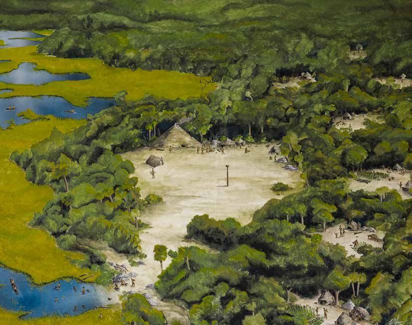
LEFT & ABOVE: Pottery fragments
                                                                                                                                recovered from Block C in 2021 included an
                                                                                                                                olive jar fragment, a sherd of San Marcos
                                                                                                                                Line Block Stamped with a central dot (left),
                                                                                                                                and a sherd of San Marcos overstamped
                                                                                                                                (right). Courtesy of UNF Archaeology Lab

unit dug in 1999 to sample a San Pedro shell midden.        who came to possess it. Perhaps it came to symbolize         chiefly residences nearby—a formal layout suggestive
That testing yielded a piece of Spanish olive jar and a     their ancestors or an ancient past with a presence and       of a town rather than a village. In the future, we hope
fragment of Mexican Red Painted earthenware. The shell      status beyond the ordinary.                                  to unearth the remains of domestic houses and other               ABOVE: A large postmold in the east wall
deposit laid at the eastern end of Block C, and plowing                                                                  place-making features. Uncovering the community                   was a major feature in Block C in 2021.
had severely fragmented and crushed oyster shells in the    Students working diligently under pandemic conditions        council house would be terrific, but that’s akin to finding       Courtesy of UNF Archaeology Lab
midden. The more robust quahog clam shells—of which         exposed more pits and possible postmolds at the              the proverbial needle in a haystack.
there were many more than usual—fared better. Animal        midden-subsoil interface, but distinctive patterns
bone was disappointingly scarce, particularly when          continue to elude us. Our excavations to date have           Through the years, our research has benefitted from           combining our respective expertise in archaeology and
compared to the bone-rich shell middens affiliated with     included numerous shovel tests, two 1 x 1-m squares          the unwavering support of Big Talbot Island State             history to recover a vast understanding of Indigenous
earlier Woodland and Mississippian period occupations       and forty-nine 1 x 2-m units. While on the surface this      Park, Friends of Talbot Islands State Parks, North            northeastern Florida.”
in other parts of the island.                               may seem like extensive excavation, it isn’t—especially      Florida Land Trust, and Timucuan Parks Foundation.
                                                            considering the size of the Armellino site, which            As the UNF Archaeology Lab moves forward with the             We wrapped up fieldwork in November. On our final
We devoted three days a week to fieldwork, and some         measures some 800 x 250 m. In truth, we have only            Mocama Archaeological Project—our long-term study             day, students packed my small Tacoma truck to the gills
students spent portions of the other two days working—      begun to scratch the surface.                                of the social histories and cultures of northeastern          with all sorts of equipment. As I drove along the island’s
in masks at socially accepted distances—in the UNF                                                                       Florida’s Indigenous populations, I am joined by my UNF       dusty dirt road, I heard a faint voice emanating from a
Archaeology Lab. A laboratory methods class began           The lack of broad-scale testing is exactly what drew         colleague and historian Dr. Denise Bossy. Her expertise       side trail, “See you next year.” To which I replied, “I sure
the arduous task of analysis, which should be completed     us back to the Armellino site. The 2020 field season         in cross-cultural relations between Indigenous peoples        hope so.”
by late spring (2021). As was the case two decades ago,     represents the first of a proposed multiyear investigation   and Europeans adds a vital dimension to our ongoing
San Pedro pottery dominates the ceramic collection,         designed to open expansive areas in the hopes of             research on the region’s long-term Indigenous history,        Dr. Keith Ashley is an archaeologist and assistant
but is closely followed by San Marcos. Additional olive     revealing clues to the physical layout of a Mocama           a history in which entanglement with Europeans is             professor of anthropology in the Department of
jar fragments from the 2020 field school bring our total    community. Currently, we lack any real understanding         but one point on a continuum that covers more than            Sociology, Anthropology, and Social Work at the
to more than 30. Students also uncovered our first piece    of what the main contact-era Native settlements in           10,000 years.                                                 University of North Florida.
of majolica, a fragment of Sevilla Blue on Blue, with an    northeastern Florida looked like.
early production date of 1550–1640.                                                                                      Combining archaeology and historiography allows for           Bibliography
                                                            If we are to take the few vague and purportedly              a more nuanced reframing of conventional historical           Bennett, Charles E., trans. 2001. Three Voyages
For many students, the most attention-grabbing artifact     eyewitness European descriptions at face value, then         narratives based mostly on uncritical readings of biased      René Laudonnière. Tuscaloosa: The University of
was an Archaic stemmed point of the Marion type (ca.        Mocama settlements should include circular domiciles         and static descriptions and observations of Native            Alabama Press.
4000–6000 BC). What made the find more exciting             and associated storehouses. At their center, we should       peoples written by European chroniclers. We also believe
was its recovery within a seemingly secure contact/         find a council house fronting a plaza and ball field, with   serious attention must be given to how precontact             Notes
early mission period context. As UNF student Ian King                                                                    circumstances shaped the contours of colonial realities       1. Charles Bennett, trans., 2001, Three Voyages René
is quoted as saying, “Oh, the story it must have to wind                                                                 of Native Americans living in northeastern Florida,           Laudonnière (Tuscaloosa: The University of Alabama
up in this site.” While thousands of years earlier it may      ABOVE, LEFT: UNF student Ian King trowels near            and beyond. Local conditions and histories are crucial        Press), 139.
have served as a projectile point or knife, its meaning        the south end of Block C in 2021. Courtesy of UNF         to explaining the diverse responses to European               2. Ibid., 96.
may have been reconceptualized among the Mocama                Archaeology Lab                                           colonization. As Denise puts it, “One of our main aims        3. Ibid., 156.
                                                                                                                         is to decolonize the study of Franciscan missions,
6        2021 Adventures in Florida Archaeology                                                                                                                                                 2021 Adventures in Florida Archaeology           7
ABOVE, RIGHT: Location of St. Vincent Island

From Paleo-Indian
                                                                                                                            in northwest Florida’s Apalachicola delta. Map
                                                                                                                            compiled by Nancy White

                                                                                                                            ABOVE: St. Vincent Island topography shows
                                                                                                                            lower, older beach ridges at the northeast

to Protohistoric
                                                                                                                            side. Lidar image by Jeff DuVernay

                                                                                                                            RIGHT: Shell midden deposits more than
                                                                                                                            2 m thick, from Pickalene midden area of
                                                                                                                            St. Vincent’s north shore, were photographed
St. Vincent Island’s Enduring Native Occupation                                                                             in the 1970s; considerably less remains today.
                                                                                                                            Photo courtesy of Frank Stapor
                                                                                          Nancy Marie White
S  t. Vincent Island is the closest barrier island to the     at the Paradise Point site (8Fr71) on the northeast           bringing the old USF truck over every morning on the        We documented 19 aboriginal sites. Though oysters
mainland in the Apalachicola delta region of northwest        edge, where a human burial had been exposed. As               government barge, getting it horribly stuck nowhere         and other seafood were available in any bay waters,
Florida. Indian Pass, at its northwest end, is only 500 m     erosion escalated, the Supporters of St. Vincent, the         near any tree to help winch it out, and losing its four-    the richest sites were near oyster reefs—Pickalene Bar
wide, and surely must have been named for the multitude       local volunteer group, saw federal managers struggling        wheel drive mechanism in the middle of the project! The     at the north shore and Dry Bar off the northeast tip of
of prehistoric Native American archaeological sites           with cultural resources protection and requested my           island’s sand roads were full of mud holes and other        the island. At St. Vincent 5 site (8FR364; also Pickalene
around it. At the southeast end of St. Vincent, West Pass     help. In summer 2009, with University of South Florida        obstructions, including a huge alligator snapping turtle    midden), we dug a 1 x 1-m test unit in arbitrary 10-cm
separates it from Little St. George Island. Triangular and    (USF) field school students, supervisor graduate              that wanted to chomp off a shovel handle (or finger) as     levels. It had undisturbed Middle-to-Late-Woodland
wide, not long and thin like most barrier formations, St.     student Elicia Kimble, and volunteers, I surveyed the         we eased it gently aside. But we covered a lot of land      oyster-shell midden extending a meter deep, with
Vincent Island is made of more than 100 dune/beach            12,358-acre island and tested the St. Vincent 5 site          and found nothing cultural in the interior, where earlier   black sand devoid of shell continuing another 10
ridges at least 1–2 m high and 30 m apart, that formed        (8Fr364). We returned in 2010 to test at Paradise             geological trenches also had not encountered any            cm below that, atop the natural white beach sand.
over the past 4,000–5,000 years. Historically, the island’s   Point. Kimble later wrote her MA thesis on the project.       artifacts or shell deposits. We concluded that native       The four diagnostics among the check-stamped and
wealthy owners used it as a hunting preserve, importing       Public archaeology included outreach to collectors.           peoples had not lived in the interior of the island or on   plain potsherds were two Keith Incised and two Swift
exotic game such as the huge Asian Sambar deer that           One was Jerry Cauthen, who had picked up artifacts for        the Gulf shores, only on the sheltered bayshores, where     Creek Complicated-Stamped. A radiocarbon date on
remain today. In 1968, the US government bought it to         twenty-five years, and who came to realize it was illegal;    there was more food and easier transportation by water.     charcoal from Level 4 was cal A.D. 870–1010, in the
be a National Wildlife Refuge. The island’s southeast tip     but he had kept notes and a computer database of sites.       Through the millennia, they accumulated linear shell        Late Woodland period. Level 10 was dated to cal A.D.
has some historic sites—19th-century structures, vague        Long after our fieldwork ended, he donated his entire         middens, more than 2 m thick, as measured in the 1970s.     560–660, in the Middle Woodland Period. The dates
outlines of short-lived Civil War Fort Mallory (8Fr359),      collection (thirty boxes we retrieved from Mississippi,       However, recent storms have been more destructive,          suggest that the 60 cm of deposits between these two
and a submerged, nameless shipwreck (8Fr56). But              where he had moved). He died in 2019, but left a great        churning up midden materials and redepositing them          levels took about 330 years to accumulate, averaging
prehistoric shell middens line the north and east shores;     scientific legacy.                                            back on the shores or washing them away completely,         18 cm of garbage per century. The abundant faunal
their artifacts, continually washing out, have been                                                                         leaving mostly the back sides of sites. Reasons for the     remains were analyzed by Rochelle Marrinan and
collected—illegally—by the thousands over the decades.        Our field tasks were surface collection, shovel testing,      increased erosion probably relate to recent climate         her FSU paleonutrition class to determine Woodland
                                                              and doing one core that was useless when loose sand           change and human action. But so far, it is unknown          diets. Eighty percent of the biomass and 92 percent
Florida State University (FSU) investigators recorded         refused to stay in the metal tube. Adventures included        specifically why archaeological sites that have sat there   of the individual animals represented were ray-finned
archaeological sites on the island in the 1960s and ’70s.                                                                   for at least 2,000 years are suddenly disappearing. Our     fish, especially mullet, but also drum, catfish, seatrout,
                                                                ABOVE: Students dig a 50-cm-square shovel test in the
James Miller surveyed in 1978 in advance of proposed                                                                        first task was to describe what was left.                   and gar. Other bones were of birds, chameleon, crab,
                                                                interior of St. Vincent Island. Head nets were crucial to
facilities construction. In 1981, Chad Braley excavated         protect against summer insects. Photo by Nancy White
8        2021 Adventures in Florida Archaeology                                                                                                                                                  2021 Adventures in Florida Archaeology         9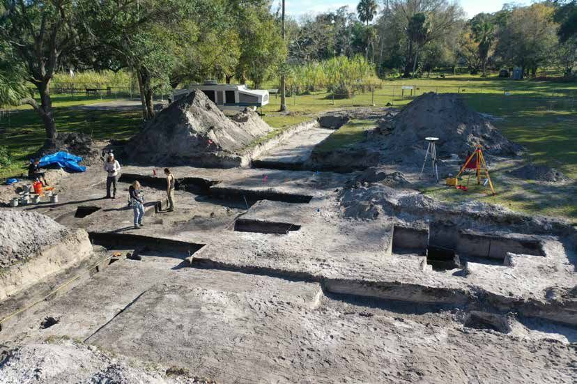
LEFT: Shell midden in 2010 at St.
                                                                       Vincent Island Ferry site (8Fr352),
                                                                       near the dock entrance to the
                                                                       island, shows how diminished the
                                                                       cultural deposits have become in the
                                                                       last forty years—and how modern
                                                                       garbage accumulates. Photo by
                                                                       Nancy White

                                                                       BELOW: Stratigraphy at Pickalene
                                                                       midden area, 1970s, shows a later
                                                                       oyster-shell midden layer overlying
                                                                       blue-gray clay that indicates higher
                                                                       sea-level stand than at present.
                                                                       Photo courtesy of Frank Stapor

                                                                             the Fort Walton ceramics of the upper        Archaic Stemmed, attributable to Middle or
                                                                             midden. Donoghue also obtained other         Late Archaic. They indicate long habitation
                                                                             radiocarbon dates on shell from the          (probably continuing on riverbanks) while the
                                                                            upper midden at A.D. 1180 and from the        island was still mainland and throughout the
                                                                            lower midden at A.D. 450 and 520. The         period during which sea level rose and the
                                                                           work supported the hypothesis that a           island was taking shape. At present, we cannot
                                                                           sea-level high-stand of approximately .7       tell if there was a hiatus in occupation around
                                                                           m above the present occurred sometime          4,000–5,000 years ago after sea-level rise
                                                                           between 1,300 and 1,000 years ago.             and before or during the island’s formation.
                                                                                                                          Ceramic Late Archaic sites are represented
                                                                            Far earlier human communities at St.          by the earliest pottery, made of clay mixed
                                                                            Vincent sites are also known from artifacts   with Spanish moss fibers, now dated between
                                                                            washing out of deeper deposits. The oldest    2500 and 500 B.C. (and so ugly only an archaeologist
                                                                           are Paleo-Indian projectile points, up to      could love it). Of the total 551 fiber-tempered sherds
land and sea turtle, deer, rabbit, rat, and, surprisingly,   14,000 years old, left by Ice-Age people at a time when      (5.3 kg), three were found during our survey, and the rest   ABOVE: Geologist Joe Donoghue maps on top of the
whale or dolphin. Invertebrates were mostly oyster, but      sea level was some 100 m lower, and St. Vincent was                                                                       upper shell midden at Paradise Point. Photo by
                                                                                                                          were in Cauthen’s collection. These numbers show how
                                                                                                                                                                                       Nancy White
included conch, whelk, ark shells, marsh periwinkle, and     not an island but 150 km inland. The island’s modern         intensively some sites were occupied (not to mention
terrestrial snails.                                          shoreline could have been riverbank then because the         the difference between professional and avocational          ABOVE, RIGHT: Image depicts the locations of
                                                             Pleistocene Apalachicola River flowed farther to the         knowledge). Other Late Archaic objects are chert             archaeological sites and excavations on St. Vincent
Investigations at Paradise Point were more limited.          west. Four sites produced 21 Paleo-Indian points: fluted/    microtools and a tiny disk bead of red Mississippi-valley    Island. Site numbers are given without the “8Fr” prefix
The site was difficult to reach, requiring an airboat        unfluted Clovis, Santa Fe or Simpson, Suwanee, and           jasper, which indicate relationships with Late Archaic       for Florida and Franklin County. Map compiled by
(or wading 700 m), and the work needed complex               others. These are not eroded or water-worn, and some         Poverty Point cultures in northeast Louisiana and long-      Nancy White
scheduling around winter tides and limited daylight.         are of translucent, unweathered chert, meaning they          distance social interconnection along the Gulf.
Geologists Joe Donoghue and Frank Stapor joined the          were well buried until recent exposure. Paleo-Indian                                                                      ABOVE, RIGHT:Geologist Frank Stapor pounds in pipe
expedition because they had long been investigating          evidence has been scarce in the region outside of the        Early Woodland (500 B.C.–A.D. 350) evidence at St.           to take a horizontal core for an OSL date from the upper
St. Vincent Island’s beach ridge formations to interpret     upper-middle portions of the Apalachicola drainage.                                                                       midden at Paradise Point. Dark gray clay below indicates
                                                                                                                          Vincent Island sites includes diagnostic Deptford Simple-
                                                                                                                                                                                       high sea-level stand. Nancy White (in heavy jacket)
sea-level fluctuations in the Gulf of Mexico. We exposed     St. Vincent Island’s ancient points mean revision of         Stamped and Linear Check-Stamped ceramics, as well           measures the depth. Photo by Elicia Kimble
a 1-m shoreline profile showing 60 cm of upper shell         the earliest settlement picture for the region. The first    as generic check-stamped pottery. Middle Woodland
midden overlying the 20-cm-thick, blue-gray clay             people must have moved along continually, covering the       sites had both Swift Creek Complicated-Stamped and
stratum with no artifacts that resulted from a sea-level     whole landscape, and the reason so few Paleo-Indian          early Weeden Island Incised, Punctated, and Plain
stand higher than at present. Below that was a lower         sites are known from the lower valley and coast is that      pottery, typical for this region. Middle Woodland (A.D.
shell midden dated by Braley to A.D. 630–700. The tide       they are deeply buried by more recent delta formation.       350–700) was the time of the greatest elaboration of
came in quickly, drowning the lower midden in our test,                                                                   burial-mound building and a fascination with fancy
but we sampled the upper midden with a horizontal core       Preceramic Archaic artifacts from St. Vincent                and exotic material culture. Though no mounds are
for optimally stimulated luminescence (OSL) dating,          Island sites are points such as Early Archaic Bolen,         known on St. Vincent Island, exotic artifacts recovered
which requires sand grains not exposed to sunlight           Hardaway/Lost Lake corner-notched types, Middle              include quartz crystal pendants, a soapstone pipe, a
since burial. The date returned, A.D. 1400, fits well with   Archaic Benton and other stemmed types, and Florida          galena cube, a cut mica fragment, and 44 greenstone
10       2021 Adventures in Florida Archaeology                                                                                                                                               2021 Adventures in Florida Archaeology             11
LEFT PAGE, TOP LEFT: Late Archaic artifacts from St.
                                                                                                                                                                                          Vincent Island—a fiber-tempered sherd, chert microtool,
                                                                                                                                                                                          and jasper bead. All photos by Nancy White

                                                                                                                                                                                          LEFT PAGE, BOTTOM LEFT: Middle Woodland exotic
                                                                                                                                                                                          artifacts from St. Vincent Island—soapstone pipe and
                                                                                                                                                                                          quartz crystal pendant.

                                                                                                                                                                                          LEFT PAGE, RIGHT: Middle Woodland pottery from St.
                                                                                                                                                                                          Vincent Island; all are Swift Creek Complicated-Stamped
                                                                                                                                                                                          (two with drilled holes for repair) except the lower left,
                                                                                                                                                                                          which is Weeden Island Incised.

                                                                                                                                                                                          THIS PAGE: Late prehistoric Fort Walton Incised
                                                                                                                                                                                          carinated bowl fragment and ceramic bird-effigy head
                                                                                                                                                                                          from St. Vincent Island.

celt fragments, all imported from great distances. Late        Fort Walton material culture disappeared by about          Dr. Nancy White is a professor of anthropology at the        Miller, James J., John W. Griffin, and Mildred L. Fryman.
Woodland (A.D. 700–1000) materials were harder to              1650. It is unknown which historic Native Americans        University of South Florida and Registered Professional      1980. Archeological and Historical Survey of St. Vincent
identify, with few artifact types diagnostic for the region,   came to St. Vincent after that, though colonial mission    Archaeologist. Her current research focuses on the           National Wildlife Refuge, Florida. Cultural Resource
just mostly check-stamped and plain ceramics.                  sources in Tallahassee mention names of native groups      Apalachicola-lower Chattahoochee valley region of            Management, Inc., Tallahassee.
                                                               like the Chine, who were coastal dwellers. Mission-        northwest Florida, southwest Georgia, and southeast
Late prehistoric Fort Walton-period components                 period Indians near the region include an unknown          Alabama.                                                     Stapor, Frank W., and William F. Tanner. 1977. Late
are the most abundant on St. Vincent Island (14                group who made Lamar pottery, sloppy grit-tempered,                                                                     Holocene Mean Sea Level Data from St. Vincent Island
sites). Diagnostics are Fort Walton Incised and Point          complicated-stamped vessels that occasionally are          Bibliography                                                 and the Shape of the Late Holocene Mean Sea Level
Washington Incised ceramics, including rim effigies.           found on St. Vincent Island, and that may represent        Balsillie, James H., and Joseph F. Donoghue. 2004. High      Curve. In Coastal Sedimentology, edited by William
These groups apparently did not farm like their                people fleeing from the violent destruction of the         Resolution Sea-Level History for the Gulf of Mexico Since    F. Tanner, pp. 35–68. Department of Geology, Florida
contemporaries upriver, but continued collecting wild          Spanish missions by the English and their Indian allies    the Last Glacial Maximum. Florida Geological Survey          State University, Tallahassee.
resources, mostly aquatic species, like their ancestors        in the early 1700s. Decades later, Creeks-becoming-        Report of Investigation No. 103, Tallahassee.
did, as evidenced in the continuous record of the shell        Seminoles moved into the region, leaving a few sherds                                                                   Walker, Karen J., Frank W. Stapor, Jr., and William H.
middens. Coastal Fort Walton people were the first to          of their distinctive Chattahoochee Brushed pottery and     Braley, Chad O. 1982. Archaeological Testing and             Marquardt. 1995. Archaeological Evidence for a 1750–
encounter Old World invaders. The 1528 expedition              early historic gunflints.                                  Evaluation of the Paradise Point Site (8Fr91), St. Vincent   1450 BP Higher-than-Present Sea Level Along Florida’s
of Pánfilo de Narváez landed near Tampa and trekked                                                                       National Wildlife Refuge, Franklin County, Florida.          Gulf Coast. In Holocene Cycles. Climate, Sea Levels,
north through the peninsula to Tallahassee. Then, sick         Explaining the successive Native American cultures         Report to the Southeast Region, U. S. Fish and Wildlife      and Sedimentation. Journal of Coastal Research Special
and starving, they went to the coast near St. Marks            on St. Vincent Island was part of the project’s public     Service. Southeastern Wildlife Services, Inc., Athens, Ga.   Issue 7:205–218.
and ate their horses while building boats to sail away.        archaeology component. We also aimed to help
Some of Narváez’s crew sailed west seven days through          management of the cultural resources by establishing a     Covey, Cyclone, trans. 1961. Cabeza de Vaca’s                White, Nancy Marie, and Elicia Kimble. 2016. Paleo-
Apalachicola Bay, according to chronicler Álvar Núñez          monitoring program, training volunteers to photograph      Adventures in the Unknown Interior of America                Indian Through Protohistoric on St. Vincent Island,
Cabeza de Vaca (Mr. Cow’s Head), one of the four known         and document in situ the artifacts washing out of          (translation of the 1537 work by Álvar Núñez Cabeza          Northwest Florida. Florida Anthropologist 69:184–204.
survivors. They approached St. Vincent, “an island close       the shores without picking them up. Additional             de Vaca). New York: Collier Books.
to the mainland,” stopped there to steal Indian canoes         recommendations were for better signs, more public
and food, then entered “a strait,” clearly Indian Pass,        education, and other policies to help protect the sites.   Kimble, Elicia. 2012. Archaeological Survey and Testing
through which they passed to emerge at the open ocean          Recent storm events, including 2018’s Hurricane            on St. Vincent Island, Northwest Florida. MA thesis,
and continue their historic journey. The Spaniards, other      Michael that devastated the entire region, and slower      Department of Anthropology, University of South Florida,
Europeans, and Africans of this expedition certainly left      processes such as sea-level rise, continue to take away    Tampa. Electronic document, http://scholarcommons.usf.
artifacts—and germs, beginning the end of local native         the archaeological record.                                 edu/etd/4349/, accessed May 20, 2015.
societies.

12       2021 Adventures in Florida Archaeology                                                                                                                                                 2021 Adventures in Florida Archaeology           13
FLORIDA PANHANDLE
SHIPWRECK TRAIL                                                                                                                            A Bridge between the
                                                                                                                                           Archaeological and Artificial                                                         Melissa R. Price

                                                                                                                                                                             All images courtesy of the Florida Bureau of Archaeological Research

                                                                                                                                                                             One of the nation’s most popular dive sites, the aircraft carrier USS Oriskany,
                                                                                                                                                                             more than 900 feet long, was sunk twenty-two miles south of Pensacola in
                                                                                                                                                                             2006. The depth ranges from 80 to 212 feet, allowing divers with different
                                                                                                                                                                             skills to have a unique shipwreck experience.

Background                                                      known of these wrecks is the USS Oriskany aircraft             Since its inception, the Trail has enjoyed marked success      toxins, stable during storm events, and made to last at
The Florida Panhandle Shipwreck Trail (Trail) was               carrier, the largest artificial reef in the world, which had   and is promoted via a website, Facebook page, popular          least twenty years (Ansley et al. 2004). Concrete, steel
launched in 2012 in response to the 2010 Deepwater              an exciting service in the Pacific Theater during the          articles, billboards, informational rack cards, and Trail      vessels, and construction material such as culverts,
Horizon oil spill in the Gulf of Mexico. Following the spill,   Korean and Vietnam Wars. Panama City also enjoys               passports that serve as souvenirs and are used to              pilings, bridge spans, and scrap metal all have served
the Panhandle experienced a dramatic drop in tourism.           ample representation on the Trail, maintaining quite a         record completed dives. Yearly distributions of the Gulf       as artificial reefs. However, the high relief and complex
As a result, the Florida Department of State, Bureau            few World War II-era vessels as well. USS Strength, USS        Tourism and Seafood Promotional Fund have been used            structure provided by steel vessels create an alluring
of Archaeological Research (BAR), used funds from a             Accokeek, and USS Chippewa (a minesweeper and two              to provide logoed shirts, stickers, koozies, and mask          habitat for fish and an exciting experience for scuba
Coastal Management Program grant to create a diving             tugboats, respectively) collectively served in Okinawa,        straps to participating dive shops and to generate             divers. For this reason, wrecks-become-artificial-reefs
trail in an effort to boost the tourism economy (Smith          Iwo Jima, the Caribbean, and Newfoundland. Other               interest in the Trail at various events.                       not only enhance the ecosystem and divert pressure
2014). With assistance and input from local waterfront          wrecks include Black Bart, an offshore oilfield supply                                                                        from diving and fishing away from natural reefs, but
communities, the shipwreck Trail was modeled after              vessel from the late 1970s, and two Florida Aquatic            Artificial versus Archaeological                               they also ultimately boost the tourism economy.
one in the Florida Keys. The twelve chosen wrecks are           and Marine Institute (FAMI) tugboats sunk in 2003 as           Most of the Trail wrecks were sunk intentionally as
situated offshore of Pensacola, Destin, Panama City,            artificial reefs. Destin and Port St. Joe have one Trail-      artificial reefs. Unlike Florida’s southeast coast, the Gulf   Furthermore, as artificial reefs, the Trail wrecks were
and Port St. Joe.                                               included vessel each. Miss Louise is a small tug with          of Mexico primarily has a sandy bottom with limited            given a new life after their initial service, allowing them to
                                                                an abundance of marine life and a resident sea turtle.         natural hard bottom and few reef-building corals. In this      continue telling their stories. These monuments beneath
Pensacola is well represented in terms of Trail wrecks:         Vamar, a steamer, enjoyed an adventurous service,              environment, artificial reefs provide an oasis of high-        the sea preserve aspects of Florida’s fascinating
San Pablo, Three Coal Barges, Pete Tide II, YDT-14,             traveling to Antarctica in 1928 and heading to Cuba            quality habitats within expansive sand-bottom areas,           maritime history, thereby facilitating education through
and USS Oriskany represent various time periods, from           in 1942 before sinking under mysterious conditions in          attracting marine life and divers alike. The process for       recreation. And education leads to preservation. The
World War II to the late 1970s. Perhaps the most well-          twenty-five feet of water.                                     implementing artificial reefs is science based and ocean       wrecks provide a bridge between the artificial and
                                                                                                                               safe. Chosen reef structures must be durable, free of          archaeological—they inadvertently educate the public
14       2021 Adventures in Florida Archaeology                                                                                                                                                         2021 Adventures in Florida Archaeology           15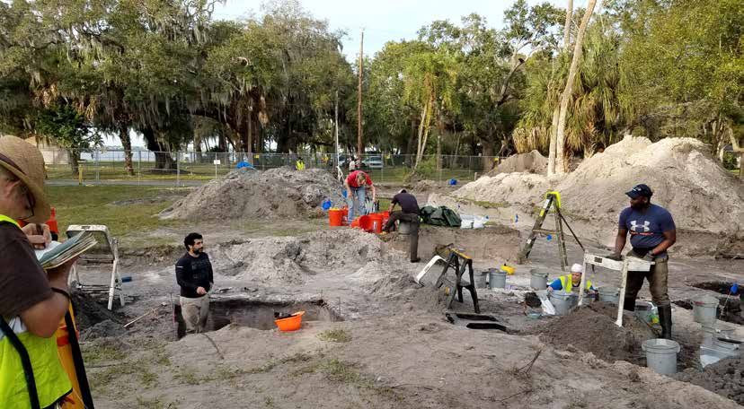
about why it is important to preserve and
protect submerged cultural resources and
underwater environments. The Trail reminds us                                                                                       The Panhandle Shipwreck Trail currently includes twelve shipwreck sites in the Gulf of Mexico,
to “take only pictures, and leave only bubbles,”                                                                                    stretching eastward from Pensacola to Port St. Joe.
stressing minimal impact diving and fostering
the notion that, if everyone took something from
a wreck or dive site for their own, there would                                                                           intact, not only to preserve their integrity, but also to       was phenomenal. The videos encouraged members of
be nothing left for other divers or generations                                                                           ensure that other divers and future generations can             the diving community to share their own experiences on
to enjoy. Given that dive shops in the Panhandle                                                                          enjoy them. Through the Trail, these issues are brought         these wrecks, and much attention was drawn to diving
rely on artificial reefs to attract business, it                                                                          to the forefront, providing a bridge to larger discussions      opportunities in the Panhandle. The Facebook page
is no wonder that local stakeholders want to                                                                              about underwater archaeology in general.                        also fostered networking with other divers and provided
foster a sense of stewardship and respect for                                                                                                                                             a platform for submission of personal photographs,
the wrecks in their offshore backyards. Using the Trail     about preservation, laws related to metal detecting,          Promoting Access to the Deep                                    videos, and stories. People who actually served on some
wrecks as a springboard, the notion of stewardship can      and what to do if a diver discovers a site. Using the         While the Trail is not totally archaeological in nature, it     of the WWII-era vessels were able to comment about
be expanded to all shipwrecks, regardless of how they       Trail, staff were able to discuss protection of submerged     can educate the public about those types of sites that          their experiences and see what the vessels looked like
came to rest on the seafloor, as well as to other types     archaeological resources with the diving community.           aren’t widely visible or easily accessible. Submerged           after years on the seafloor. The photos included in this
of submerged sites, such as prehistoric shell middens,      Positive and effective outreach and engagement                sites are often “out of mind,” but the Trail is one way in      article are a result of the 2018 videography project,
habitation areas, and harbors. Furthering this dialogue     with this audience is necessary to foster stewardship         which underwater archaeology can be made relevant               which also led to opportunities to publish in well-
is something BAR has been fostering for many years.         of all submerged resources, not just artificial reefs.        to the wider public. In considering this concept, BAR           regarded diving magazines (Price 2019a, 2020). The
                                                            Misconceptions about preservation and ownership can           staff recognized a need for high-quality video footage          360-degree immersive experiences were particularly
Bridging the Gap                                            lead to removal of artifacts or structural elements from      of the Trail wrecks for distribution among the non-diving       valuable to non-divers, because viewers could virtually
This dialogue was exemplified during BAR’s attendance       shipwrecks, to their detriment. At DEMA, staff were able      community. As a result, in 2018 staff worked closely with       experience the wrecks as if they were diving themselves.
at the Diving Equipment and Marketing Association           to shift the narrative to one of shared custodianship         a production team to create a series of promotional             The high-quality media brought renewed interest in
(DEMA) Show in 2019 (Price and Mollema 2019). The           and protection in the context of the Trail. The Trail         videos and 360-degree immersive experiences that                the Trail and ultimately sparked suggestions for an
DEMA Show represents the largest gathering of dive          also offered an opportunity to draw a connection to           could be shared across a variety of platforms. For this         expansion.
professionals and diving industry individuals worldwide.    other archaeological sites by highlighting the maritime       project, BAR’s underwater archaeologists joined a
Hundreds of exhibitors are attracted to DEMA each           history of the Gulf and the importance of leaving sites       production team in Pensacola, Panama City, and Destin           The Way Forward
year and include scuba equipment manufacturers,                                                                           to dive and collect video footage on eight of the twelve        Because the Destin and Fort Walton Beach areas have
ocean researchers, and scuba diving businesses. Here,                                                                     wrecks (Price 2018). The dives were followed with               only one wreck on the Trail, local stakeholders requested
                                                                Launched in October 1945, USS Oriskany was one of         topside interviews with archaeologists, who discussed           an expansion to bring more tourism to the area. A
BAR staff disseminated information about the Trail,             the few Essex-class aircraft carriers completed after
Department of State, the Bureau’s archaeological                                                                          the history of the wrecks, their importance to the local        number of candidates were suggested by community
                                                                World War II. It could carry up to 103 aircraft. Known
programs, and protection of submerged archaeological                                                                      economy, how they fit within the overall Trail, and what        members, and after discussions with dive shops, DEMA
                                                                by a variety of nicknames—Mighty O, the O-boat, and
resources. Staff found that the Trail served as a jumping       the Big Risk, the vessel was named after the Battle of
                                                                                                                          it was like to dive on them. The videos were (and still are)    Show 2019 attendees, and the Florida Fish and Wildlife
off point from which visitors asked other questions             Oriskany, August 6, 1777, a significant and very bloody   hosted on a website, floridapanhandledivetrail.com, and         Conservation Commission, eight additional vessels
                                                                conflict in New York during the American Revolution.      shared on Facebook. Public response to the footage              were chosen (Price 2019b).
16       2021 Adventures in Florida Archaeology                                                                                                                                                     2021 Adventures in Florida Archaeology      17
Offshore of Destin, five tugboats will be included on the After the success of the first videography project,
ABOVE & LEFT:
Trail website and outreach materials—Tugboat “Zuess,” BAR staff again will join a production team to collect A 143-foot fleet tug, USS
Mohawk Chief at Sand Dollar Complex #7, Chepanoc at video footage on at least six of the new additions. Accokeek hauled in ships
Starfish Reef, Belize Queen at Bob Reay Reef, and M/V In a continuing effort to “bridge the gap,” BAR will for maintenance before
Janet at Fish Haven #6. Most of the tugboats were sunk expand the Trail narrative in the next video series being transferred to the
with accompanying concrete artificial reef structures, to include a discussion of the difference between US Navy diving school in
which add to divers’ underwater experiences. Another archaeological shipwrecks and artificial reefs, the Panama City for salvage
addition in this area is the Destin Liberty Ship, also known types of archaeological sites distributed throughout and ordinance training.
as Thomas Hayward. History enthusiasts will appreciate Florida’s Panhandle, and the importance of protecting She was sunk in 2000,
a visit to this World War II-era Liberty Ship, which was submerged sites in Florida. It also will discuss the fact coming to rest in 100 feet.
active until 1949 and transported allied troops from the that historical wrecks that become artificial reefs are
United States to Europe. Another historical addition to a great way to preserve Florida’s cultural resources
the Trail includes Empire Mica, accessible via Panama and make them accessible to the public. Including
City, Port St. Joe, or Mexico Beach. During World War historical wrecks on the Trail is one way to protect
II, this British tanker carried fuel for the Royal Air Force vessels with a significant history. Exhibited in their
before being torpedoed by a German U-boat, twenty- underwater environment, they gain a new purpose, There is engagement and interest in underwater (@FloridaPanhandleShipwreckTrail) for updates on
one miles south of Cape San Blas. While much of the especially considering that many of these vessels archaeology, but there are also misconceptions. As Videography Project 2.0. Though it was postponed
upright structure has since deteriorated due to time already had multiple lives throughout their service. cultural resource managers, we are responsible for due to the pandemic, when it is safe to return to travel
and Coast Guard test bombing, the wreck offers a Vessels that sunk catastrophically, such as Vamar and active outreach and education that prioritize protection and diving, BAR will continue with a new video series.
fascinating story and draws many divers to this area, Empire Mica, illustrate the complexities of studying an of our shared cultural heritage. The Florida Panhandle For those interested in a virtual experience, all of the
which is why it was chosen. A final and unique addition archaeological shipwreck. In visiting the wrecks, divers Shipwreck Trail is the synthesis of recreational, 2018 videos can be found at https://www.youtube.
was quite recently deployed on the seafloor—El Dorado, can appreciate the challenge of identifying various ecological, and heritage tourism, and it promotes com/channel/UCdnz20Jg_zshN7aD3j9sbfw/videos.
a modern luxury cruise liner that washed ashore structural components on an actual archaeological site. responsible visitation to and management of artificial The 360-degree immersive experiences are best viewed
in October 2018 after the devastating Hurricane These wrecks also challenge the notion that submerged reefs and historic wrecks. on a mobile device to gain the full effect.
Michael. Accessible via Panama City, it was donated sites should be recovered completely to ensure their
as an artificial reef by the vessel’s owner, allowing Bay protection. Instead, they are examples of successful Interested in Diving the Wrecks? Melissa R. Price is a senior archaeologist and co-diving
County to reap the benefits for years to come, much to approaches to in situ preservation and interpretation. There is something for everyone on the Trail, from divers safety officer at the Florida Bureau of Archaeological
the enjoyment of divers and marine life alike. El Dorado with an open-water certification to those who have Research. She is also a PhD Researcher and Affiliated
provides a reminder of Florida’s long history with the technical training. Visit floridapanhandledivetrail.com Fellow at Leiden University’s Faculty of Archaeology. Her
ABOVE: After servicing offshore oil rigs in the Gulf
destructive forces of hurricanes, but also illustrates how for many years, Pete Tide II became an artificial to learn about the fascinating histories of each of these dissertation research focuses on the effects of Holocene
an unfortunate situation can lead to opportunity and reef in 1993. Resting in 100 feet of water, the vessels and to locate participating dive shops on the sea level rise on an inundated Archaic period site in the
positive outcomes. vessel is 166 feet long. “Trail Partners” page. You also can follow us on Facebook Gulf of Mexico.
18 2021 Adventures in Florida Archaeology 2021 Adventures in Florida Archaeology 19May 20-22, 2021
Accessible online at MYFLORIDAHISTORY.ORG
The Jillian Prescott Memorial Lecture
GILBERT KING
Pulitzer Prize winning author of the books Devil in the
ABOVE: Miss Louise, 95 feet long, was a push Grove: Thurgood Marshall, the Groveland Boys, and
tug that was sunk in 1997 as an artificial reef. the Dawn of a New America, and Beneath a
Resting upright on a sandy bottom, the wreck Ruthless Sun: A True Story of Violence, Race, and
is in 60 feet of water. Justice Lost and Found. King has also written about
race and criminal justice for the New York Times, the
LEFT: A World War II minesweeper, USS Washington Post, and The Atlantic. He attended the
Strength saw action in the Pacific Theater University of South Florida and currently lives in
and later served as a training hulk for Navy Brooklyn, New York.
salvage divers. Sunk in 1987, she lay on her
side until Hurricane Opal righted her in 1995. Presented Saturday, May 22, at 2:00 pm
Eighty feet deep, the ship is in two sections,
Bibliography/Notes stretching about 185 feet long. May 20-22, join us online for our annual Awards Presentation, and the Panel Discussions:
Ansley, Henry, C., Michael Bailey, Dennis Bedford, Mel
Territorial Florida in 1821
Bell, Mike Buchanan, Les Dauterive, Jon Dodrill, Bill
Figley, Jim Francesconi, Stevens R. Heath, Bill Horn, Emancipation Day in Florida
Rick Kasprzak, Chris LaPorta, Vin Malkoski, Robert ----------. 2020. The Florida Panhandle Shipwreck Trail. The Florida Land Boom of the 1920s
M. Martore, Michael H. Meier, Keith Mille, Richard X-Ray Mag, 99:6–10; xray-mag.com/content/florida- Fifty Years of Walt Disney World: Florida B.D. (Before Disney) and A.D. (After Disney)
Satchwill, Dale Shively, Frank Steimle, Jeff Tinsman. panhandle-shipwreck-trail.
2004. Guidelines for Marine Artificial Reef Materials, With many Distinguished Panelists including:
Second Ed., No. 121. A Joint Publication of the Gulf and Price, Melissa and Ivor Mollema. 2019. DEMA
Atlantic States Marine Fisheries Commissions. Show 2019: Post Conference Report. On file at the
Florida Division of Historical Resources, Bureau of
Price, Melissa. 2018. Florida Panhandle Shipwreck Trail Archaeological Research, Tallahassee.
Videography Project. On file at the Florida Division
of Historical Resources, Bureau of Archaeological Smith, Lindsay S. 2014. The Florida Panhandle
Research, Tallahassee. Revised, March 2019. Shipwreck Trail: Promoting Heritage Tourism in the
Digital Age. In Between the Devil and the Deep: Meeting
----------. 2019a. The Florida Panhandle Shipwreck Challenges in the Public Interpretation of Maritime
Dr. James M. Denham Dr. Canter Brown, Jr. Dr. Susan Parker Dr. Julian Chambliss Dr. Rick Foglesong Dr. Cher Knight
Trail. NAUI SOURCES, 58–61; flipbooks.naui. Cultural Heritage, Della A. Scott-Ireton, editor, pp. 109–
org/179461/179953/209988/NAUIQ119/index. 118. New York: Springer. THE FLORIDA HISTORICAL SOCIETY VIRTUAL PUBLIC HISTORY FORUM IS BEING PRESENTED AT NO EXPENSE TO THE
html?page=58. PUBLIC AS A COMMUNITY SERVICE. IF YOU WOULD LIKE TO SEE THIS KIND OF FREE EDUCATIONAL OUTREACH
CONTINUE, PLEASE CONSIDER MAKING A DONATION TO FHS FOR THIS PURPOSE.
----------. 2019b. Florida Panhandle Shipwreck Trail
Expansion Proposal. On file at the Florida Division WWW.MYFLORIDAHISTORY.ORG
of Historical Resources, Bureau of Archaeological
Research, Tallahassee.
20 2021 Adventures in Florida Archaeology 2021 Adventures in Florida Archaeology 21You can also read


