The Canadian Agriculture Weather Prognosticator
←
→
Page content transcription
If your browser does not render page correctly, please read the page content below
TO SUBSCRIBE CALL 913-383-1161 OR WRITE TO WORLDWEATHER@BIZKC.RR.COM
The Canadian Agriculture
Weather Prognosticator
Volume XIII, Issue X http://www.worldweather.cc September 3, 2021
World Improving Harvest Weather For Wet Areas
Weather At Weather conditions well for some of the areas od of unsettled weather,
A Glance across the Prairies are in the Prairies that failed but that is not going to be
trending drier now follow- to get significant rain over the case. For the next ten
Western U.S. corn and ing a few weeks of fre- the past few weeks. Some days most of the Prairies
soybean areas have ex- quent and sometimes sig- of the areas that missed will not be bothered by
perienced a significant nificant rainfall. The drier out on the greatest rainfall much “serious” rainfall
boost in topsoil mois- weather will last at least were in the southwestern and most of the wettest
ture that has stopped the next ten days offering Prairies and in particular areas will have a chance to
the decline in soybean potential for improved the east-central and south- dry down.
production potential field working conditions. eastern parts of Alberta as
well as some areas in The most impressive
Southeastern Europe’s There will be another west-central and south- boost in soil moisture in
dry bias has also been opportunity for rain later western Saskatchewan. the Prairies has been in
briefly slowed by rain this month for those areas Manitoba and in a few
that missed recent rain, In contrast, areas in eastern Saskatchewan
Brazil rainfall late this but concern remains that the southeastern Prairies locations where the out-
month through October the overriding bias for the and some in western Al- look for next spring might
will be very important Prairies will be a north- berta actually received be better if the moisture
for early corn and soy- westerly flow pattern aloft rain too often for a while received can be conserved
bean planting this autumn and winter and fieldwork was on hold in the soil until then. Dry-
that will perpetuate a lim- for a while. This delay ing is expected to domi-
Argentina is still drier ited precipitation pattern. generated a little fear that nate a large part of the
biased in the west, de- the drought would be fol- autumn and the situation
spite recent rainfall That may not bode very lowed by an extended peri- will be closely monitored.
Drought potentials in
the U.S. Plains and
western Midwest is still
moderately high for
2022 with hard red win-
ter wheat areas expect-
ing to dry out this au-
tumn
India’s Monsoon has
performed well this
year
Australia’s winter crop
areas are poised for
good crop performance
this year, although wor-
ry over a wet harvest
remains.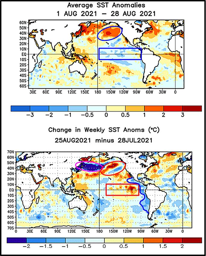
VOLU ME X III ISSUE X         T HE C A NAD I A N AG R IC U LTU RE WE AT HER PR OG NOS T IC AT OR                          PAGE 2

       Prairies Drought Not Over; Worry To Carry Into 2022
   No one in the eastern Prairies can     cult for a serious soaking of rain.                   La Nina winters normally include
complain too loudly about the rain                                                          cold temperatures and frequent snow
that has fallen since mid-August.             Now, most of us remember years                of significance along the front range
Manitoba and parts of eastern Sas-        in the past in which weather across               of mountains and nearby crop areas
katchewan received some badly need-       the Prairies in the autumn became                 in southwestern Alberta, Those areas
ed rain that might have occurred too      quite wet and that is always a possi-             and far southern Alberta as well as
late for most crops, but the moisture     bility, but looking at the anticipated            the far southwestern corner of Sas-
as needed for 2022. Hopefully, the        upper air wind flow pattern it may be             katchewan and Montana will experi-
moisture will not be lost to evapora-     difficult to get a general soaking to             ence enough winter snowfall to im-
tion between now and the winter           take place in October. Not impossi-               prove runoff and spring moisture
freeze up.                                ble, but difficult.                               potentials. It would be best if the
                                              A southwesterly flow pattern aloft            snow falls soon enough to blanket the
    In contrast, many areas in east-                                                        ground before bitter cold air arrives.
central and southern Alberta, south-      is needed to induce a wet weather
                                          pattern this autumn. The 18-year                  That way the moisture will soak into
western and west-central Saskatche-                                                         the soil as warming takes place peri-
wan and a few pockets in other areas      cycle suggests that the periods in
                                                                                            odically in the winter. If the ground
of the Prairies are                                                                                            freezes before the
still critically dry,                                                                                          snow falls then the
despite a little rain-                                                                                         potential for the
fall recently. Some                                                                                            moisture to get
areas in this dry                                                                                              into the soil will be
region received al-                                                                                            much reduced.
most no rain over
the past few weeks                                                                                                 The bottom line
while others re-                                                                                               is this….net drying
ceived some, but                                                                                               will occur for the
not nearly enough                                                                                              next ten days fol-
to change the bot-                                                                                             lowed by a new
tom line.                                                                                                      period of possible
                                                                                                               unsettled weather
   Drought is cer-                                                                                             that may be cen-
tainly not over in                                                                                             tered on the second
the Prairies and                                                                                               half of this month.
World Weather,                                                                                                 That will be fol-
Inc. is concerned                                                                                              lowed by the devel-
about the weather                                                                                              opment of La Nina
patterns that are                         which we experience a southwesterly               and a change in upper air wind flow
expected this late autumn and winter.     flow pattern aloft will be extremely              that will not stop precipitation from
The patterns are not going to allow       short in duration and limited in                  coming, but reduce its frequency and
much additional relief for some areas     number. That does not mean we can-                significance. Winter will be cold and
and that leaves the drier parts of the    not get significant moisture to fall,             dry in the heart of the Prairies, but
Prairies in a very tenuous position for   but it does mean the events will be of            wet biased in the southwestern part
spring 2022.                              short duration which limits the po-               of Alberta and extreme southwestern
    Do not read more into this than       tential for us to get enough moisture             Saskatchewan. That will offer some
what is being stated. There will be       in the dry areas to remove the con-               moisture for use in the spring to
other opportunities for moisture prior    cern about early spring 2022.                     those areas. The remainder of the
to the annual freeze up and another                                                         central Prairies will likely come to
                                             La Nina is supposed return in                  spring with large moisture deficits
round of unsettled weather should         October. Once that pattern is in
occur in the second half of this month.                                                     still remaining and a deep concern
                                          place it will be reinforcing the north-           over spring precipitation.
The problem with that period of unset-    westerly flow pattern aloft and that
tled weather is that there may be a       will restrict the amount of moisture                  The colder winter this year should
little more cool air around which will    that will be present in our atmos-                keep our snow around longer than
push the jet stream to the south and      phere reducing the potential for the              last year even if it is light and the
that will reduce precipitable water in    big storms, but not removing that as              moisture as it melts will help at least
the atmosphere making it more diffi-      a potential entirely.                             a little in getting started in 2022.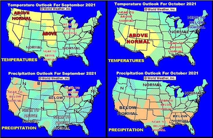
VVOOLU  ME X1I,I I,ISSUE
       L U ME           ISS UE8 X   TTHE
                                       HECCAANAD
                                              NADI A
                                                   I ANNAG
                                                         AGRRIC
                                                              ICUULTU
                                                                   LTURE
                                                                       RE WE
                                                                          WEAT
                                                                             ATHER
                                                                                HERPR
                                                                                    PROG
                                                                                       OGNOS
                                                                                          NOSTTIC
                                                                                                ICAT
                                                                                                   ATOR
                                                                                                      OR                        PAGE 3

                             September Weather Bias Too Familiar
    September weather is expected            near normal precipitation as will the              ba/U.S. border. That will not be
look much like that of the entire sum-       Interlake region of Manitoba. Most                 enough precipitation to seriously
mer with precipitation often being           other areas will experience at least a             change the moisture profile, but every
limited and temperatures warmer              slightly below average precipitation               drop of precipitation will be welcome.
than usual. The driest part of the           bias if not a more notable shortage of
Prairies will be the same region that        new moisture.                                         Farther to the north precipitation
is already driest, including the south-                                                         will be more limited once again. Much
west and west-central parts of Sas-             Temperatures in September will                  of west-central and northwestern Sas-
katchewan, southern and east-central         also be a little warmer than usual.                katchewan and east-central and far
Alberta and a few neighboring areas.         The greatest warmth will occur in                  northeastern Alberta through Prince
                                             and near to the Number One High-                   Albert and Saskatoon to Hudson Bay
   Precipitation elsewhere will be           way and areas south to the U.S.                    and Swan River, Manitoba will get
near to below average which does not                                                            below average precipitation along
translate into much potential for a             October will be the best month for              with west-central Manitoba and ex-
notable boost in topsoil moisture. The       some additional precipitation to im-               treme east-central Saskatchewan.
exception will be in the southern            pact the Prairies. The greatest mois-
Peace River region and in particular         ture will fall near the Rocky Moun-                   Temperatures in October will be
from Grand Prairie and Grande                tains in Alberta and from Slave Lake               cooler than usual in much of the
Cache to Slave Lake; including the           to Edson and westward to the Grand                 eastern Prairies while near to above
Swan Hills, the Fox Creek, White-            Prairie and Grande Cache areas.                    average out in the west.
court and Edson areas. Fieldwork                                                                    Looking ahead into November,
                                                Another area of relatively normal
may be delayed in that region addi-                                                             World Weather, Inc. sees some light
                                             precipitation will impact areas near
tionally this autumn due to rain and                                                            precipitation and cooler biased weath-
                                             the U.S. border from southern Alber-
eventually some snow. Much of the                                                               er.
                                             ta to the far southwestern Manito-
Highway 2 corridor in Alberta will see

                                                                                                           LOW CONFIDENCE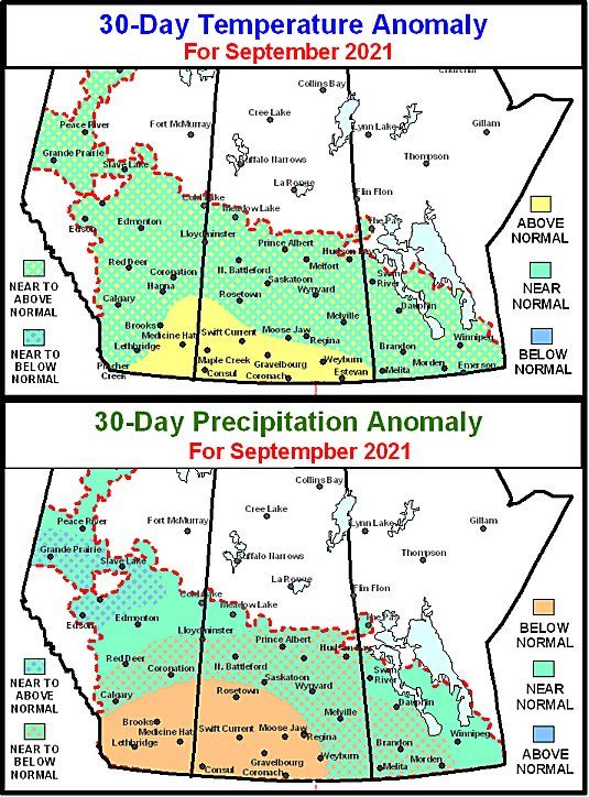
V O L U ME X I I I, ISS UE X   T HE C A NAD I A N AG R IC U LTU RE WE AT HER PR OG NOS T IC AT OR               PAGE 4

Selected Weather Images From Around The World

    Canada’s Prairies are still among the driest areas in the world, despite recent rain. Portions of central and eastern
Russia’s crop areas have dried out this summer and autumn and like trouble spots in North America this area may
deal with dryness again next year. Dryness in the United States was eased across the western Corn and Soybean Belt
while a part of the U.S. Plains were still drier than usual. Dryness in southeastern Europe, like the western U.S.
Corn Belt has been partially eased from dryness in the past couple of weeks. Argentina also received some significant
rain during the last days of August and first days of September lifting topsoil moisture ahead of new season wheat
growth improving crop development potentials. Dryness is still a concern, though, in Cordoba and Santiago de Estero,
Argentina and in Queensland, Australia. France has been drying out recently while a large part of central through
northeastern Europe has trended wetter. Southern Brazil remains favorably moist while rain is needed elsewhere.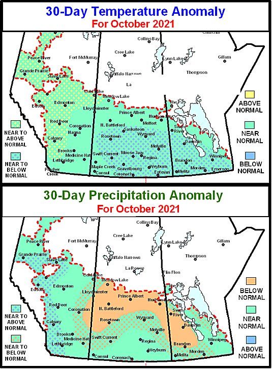
V O L U ME X I I I, ISS UE X        T HE C A NAD I A N AG R IC U LTU RE WE AT HER PR OG NOS T IC AT OR                        PAGE 5

                               Central India May Get Too Much Rain
   Gujarat and much of southern             as of Maharashtra and Gujarat to                 Moisture totals by next Friday morn-
and eastern Rajasthan recently re-          the west. Scattered showers and                  ing will range from 0.25 to 1.00 inch
ceived much-needed rain. These are-         thunderstorms will occur often before            and locally more. Western Rajasthan
as were gradually drying down to-           and after this event and the com-                will remain too dry for aggressive
ward the end of August before recent        bined rainfall for the week ending               growth and concern will remain high
rain replenished soil moisture. There       next Friday morning will range from              for production cuts in unirrigated
were growing concerns over slowed           2.00 to 6.00 inches in much of central           production areas; including guar as
crop development, most notably in           India. However, the greatest rain                well as some cotton, grain and
some of the cotton and soybean areas        will fall to the left of the monsoon             oilseed crops. Portions of Punjab will
of Gujarat. Development conditions          depression center suggesting 4.00 to             also remain a little too dry for ideal
improved as the rain fell. Additional       10.00 inches will occur across much              growth, though the rain should help
precipitation is slated for these areas     of Telangana to central and north-               support some new development.
through mid-month that will main-           eastern Maharashtra
tain a favorable environment. Most                                                              With that said, it is very im-
other production areas saw good crop           Flooding will be possible in many             portant to remember that early sea-
conditions during the past week and         areas, but the region from Telangana             son cotton is already in the open boll
will see mostly favorable conditions        and northeastern Andhra Pradesh to               stage of development in northwest-
persist through the end of next week;       northeastern Maharashtra will be                 ern India and too much rain now
although flooding rain may evolve in        most impacted and some crop dam-                 would harm some of those crops.
parts of central India.                     age should be expected.
                                                                                                           The remaining produc-
   Two significant, late                                                                               tion areas in eastern,
season monsoon depres-                                                                                 southern, and northern
sions are expected to evolve                                                                           India will see a good mix of
in the Bay of Bengal during                                                                            monsoonal rain and sun-
the coming ten days and                                                                                shine through the end of
move inland across the                                                                                 next week. Rainfall will
heart of India. These two                                                                              range from 1.00 to 4.00
systems will generate some                                                                             inches with local amounts
heavy to excessive rainfall                                                                            of 6.00 inches or more from
over ground that is already                                                                            Uttar Pradesh into Bihar,
saturated and that may                                                                                 Bangladesh, and the East-
lead to some significant                                                                               ern States. Portions of
flooding. Each of these                                                                                Tamil Nadu and southern
monsoon depressions will                                                                               fringes of Karnataka and
diminish over central India                                                                            Andhra Pradesh will also
with remnants to drift far-                                                                            only receive 0.50 to 1.00
ther to the west and northwest                                                                         inch of rain. The environ-
reaching into Gujarat and Rajasthan            Gujarat and much of southern,                 ment will remain mostly favorable
where some extremely beneficial late        central and eastern Rajasthan will               for aggressive development through
monsoon season rain will fall just          also get rain from this first monsoon            the end of next week, though pockets
head of the monsoon withdrawal.             depression. Cotton, corn, sorghum,               in Tamil Nadu may trend a little too
The moisture in Gujarat and Raja-           soybean, groundnut and rice crops                dry at times.
sthan will be ideal for late season         will all benefit from the moisture as
                                            will some pulses. No flooding of sig-               Some computer weather forecast
crop development, but the rain in
                                            nificance will occur in these areas,             models have suggested a second
central India may culminate in some
                                            but the ground will become saturat-              monsoon depression may evolve in
notable flooding.
                                            ed. The remaining areas in central               the Bay of Bengal at the end of next
   The first monsoon depression is          India will have plenty of moisture for           week around Sep. 10. If that system
expected to move from Odisha and            aggressive growth.                               evolves it could move on a path very
far northeastern Andhra Pradesh                                                              similar to that of this coming week
Sunday through southern Chhattis-               Western and northern Rajasthan               producing another wave of signifi-
garh to Madhya Pradesh by Tuesday           into Punjab will only have a few op-             cant rain across central India and
morning and it should dissipate over        portunities for rain through the end             further raising concern over the con-
southern Rajasthan shortly thereaf-         of next week. Much of the rain will              dition of many crops. More flooding
ter. Rain will fall heavily along this      occur today and again toward the                 might occur if the second depression
path and into some neighboring are-         middle and latter part of next week.             evolves as advertised.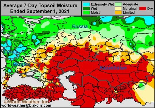
V O L U ME X I I I, ISS UE X   T HE C A NAD I A N AG R IC U LTU RE WE AT HER PR OG NOS T IC AT OR                        PAGE 6

   La Nina’s Slow Return Will Be Good For Some Areas
    La Nina will be making a slow          seed planting late this month after               slightly cooler than usual. The warm-
return to the world weather scene          some significant warming takes                    ing trend was expected to linger into
over the next several weeks. The           place. The bulk of planting will come             early September which is the reason
event is expected to be weaker than        after the nation becomes safe from                why aggressive La Nina development
last year’s La Nina and its slower         frost and freeze events. Eventually,              is not very likely.
evolution should be timely for some        traditional La Nina conditions will
crop areas to bypass some of the           evolve and that will dry out some                    However, the subsurface ocean
more threatening impacts that can          important corn and sunseed produc-                water temperatures in the eastern
occur in such an event. Brazil and         tion areas raising crop moisture                  equatorial Pacific Ocean were defi-
Argentina should be                                                                                      nitely cooler biased as
among the bigger win-                                                                                    they have been since late
ners of a slower La Nina                                                                                 July. The cool ocean wa-
evolution, but eventually                                                                                ter pool beneath the sur-
traditional anomalies                                                                                    face in the eastern equa-
are expected and that                                                                                    torial Pacific is poised to
could bring a more clas-                                                                                 be lifted upward toward
sic response to crop are-                                                                                the surface by an
as around the world.                                                                                     upwelling current of wa-
                                                                                                         ter.
   Neutral ENSO condi-
tions were still present                                                                                    The upwelling cur-
across the eastern equa-                                                                                 rent has not been very
torial Pacific Ocean at                                                                                  strong recently. Fore-
the end of August and                                                                                    casters are looking for a
the ocean surface tem-                                                                                   strong easterly wind to
perature changes noted                                                                                   develop across the sur-
at that time were mixed                                                                                  face of the eastern equa-
enough to suggest no                                                                                     torial region of the Pacif-
aggressive movement to                                                                                   ic Ocean to help enhance
La Nina conditions was                                                                                   the upwelling current. A
going to occur in Septem-                                                                                boost in easterly surface
ber. If that statement is                                                                                wind speeds will proba-
true then Brazil’s soy-                                                                                  bly occur late this month
bean country will have a                                                                                 and in October at which
much better opportunity                                                                                  time the upwelling of
to experience a relatively                                                                               cold ocean water will
normal distribution of                                                                                   become more significant
pre-monsoonal showers                                                                                    and La Nina will make a
and thunderstorms in                                                                                     more notable advance-
the second half of Sep-                                                                                  ment in its development.
tember and early Octo-                                                                                        Later this month
ber. An aggressive evolu-                                                                                  there should also be po-
tion into La Nina would                                                                      tential for the cold water beneath the
hinder the rainfall and could result       stress potentials that might harm                 surface of the ocean to possibly inten-
in a poor start to the rainy season        yields in time.                                   sify. However, there is a tongue of
like last year, but that does not seem                                                       warmer ocean water that has shifted
very likely based on the latest data.         August ocean temperature chang-                east of the International Dateline
                                           es in the eastern equatorial Pacific              recently and that may reduce the
   For Argentina, the slow evolution       Ocean were mixed with areas near
into La Nina will also help the na-                                                          intensity of the cool pool for a little
                                           the coasts of South America and Cen-              while in early to mid-September. The
tion’s winter wheat crop get some          tral America turning cooler while
timely rainfall in September. That                                                           warm tongue of water in the subsur-
                                           warming occurred in a much larger                 face ocean water should break away
moisture will be good for early sea-       part of the eastern equatorial Pacific
son crop development. The moisture                                                           from the larger pool of warm water
                                           Ocean. The warming trend occurred                 in the western Pacific Ocean limiting
in Argentina will also help support a      while ocean surface temperatures at
favorable start to early corn and sun-                                                       the duration of any warming trend in
                                           the end of August were near to just               eastern Pacific subsurface water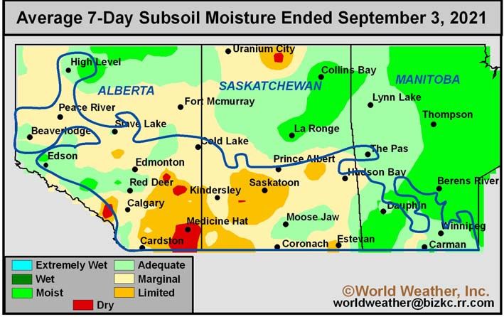
V O L U ME X I I I, ISS UE X            T HE C A NAD I A N AG R IC U LTU RE WE AT HER PR OG NOS T IC AT OR                                            PAGE 7

La Nina’s Slow Return Good For Some Areas                                                                                          (continued from page 6)

temperatures.                                          ter will be cold and drier biased and                  more significant than that of last
                                                       the same may be true for a part of                     year. Argentina will have a dry bias
    NOAA’s computer forecast model                     central Asia. Western Europe may be                    in the east, but western crop areas
continues to be a leader in ENSO                       warmer biased with less than usual                     where the largest portion of corn,
event predictions, although it gets a                  precipitation and China weather will                   soybeans, peanuts and sorghum are
little too aggressive at times. The                    be mixed with a warmer bias to the                     produced should experience a good
latest model forecast suggests aggres-                 winter, despite a few impressive                       distribution of rain this summer.
sive evolution of La Nina conditions                   drops in temperature infrequently.                     Dryness in eastern Argentina, Uru-
this month, but for the reasons we                                                                            guay, southern Paraguay and
have already stated we believe that                       Australia weather is expected to                    southern Brazil will result in some
the more aggressive cooling of ocean                   be fine through the spring, but this                   negative impact on summer crop
surface water will be delayed until                    summer there will be a rising poten-                   yields.
late this month and it will be greatest                tial for excessive rainfall in Queens-
in October.                                            land and New South Wales. That wet                        Coffee, sugarcane and citrus are-
                                                                                                                               as of Brazil will
   Because of this                                                                                                             experience an er-
slower evolution in                                                                                                            ratic start to the
La Nina, the anom-                                                                                                             rainy season fol-
alies of weather                                                                                                               lowed by a favora-
around the world                                                                                                               ble distribution of
that are often asso-                                                                                                           rain. The amount of
ciated with La Ni-                                                                                                             rain that falls in
na will not likely                                                                                                             Sul de Minas and
have a big presence                                                                                                            parts of Sao Paulo
until October. Mid-                                                                                                            may be lighter than
October through                                                                                                                usual during the
February is the                                                                                                                late spring and
period in which La                                                                                                             summer, but the
Nina will likely                                                                                                               timeliness of rain
have the greatest                                                                                                              should be sufficient
influence around                                                                                                               to support most
the world. That                                                                                                                crop needs. The
means a boost in                                                                                                               flowering season
tropical rainfall for                                                                                                          for coffee and ini-
central Africa, In-                                                                                                            tial weather in sug-
donesia, Malaysia,                                                                                                             arcane areas will
parts of southern                                                                                                              be dominated by an
and eastern India                                      bias may threaten wheat, barley and                    erratic and uneven distribution of
and the tropical regions of South                      canola as they mature and are har-                     rain possibly resulting in some
America. Mid-latitude reductions in                    vested. Flooding could evolve in some                  aborted coffee flowering and per-
precipitation should become noticea-                   sugarcane and cotton production are-                   haps a s low start to aggressive sug-
ble in the late autumn and winter for                  as of eastern Queensland in the first                  arcane and citrus development.
the northern Hemisphere and for a                      quarter of 2022 and/or possibly in
part of the southern Hemisphere                        December.                                                 Southern Europe and North Af-
crops during their mid-summer.                                                                                rica winter crop areas should expe-
                                                           In South America, the culmination                  rience a more favorable rainfall dis-
   This year’s La Nina will be play-                   of a peaking La Nina event and a few                   tribution during the heart of winter
ing out while a few other interesting                  other anomalies in the atmosphere                      and the same may be true for the
weather phenomena are present and                      will set the stage for a dry bias to                   Middle East. Spain may be the ex-
that too will alter the impact of this                 evolve in southern Brazil, southern                    ception with a warm and drier bias
year’s event. For North America, win-                  Paraguay and Uruguay that will be                      expected at times this year.

World Weather, Inc. forecasts and comments pertaining to present, past and future weather conditions included in this report constitute the corporation's judg-
ment as of the date of this report and are subject to change without notice. Comments regarding damage or the impact of weather on agricultural and energy as
well as comments made regarding the impact of weather on the commodity and financial markets are the explicit opinions of World Weather, Inc. World Weath-
er, Inc. can not be held responsible for decisions made by users of the Corporation's information in any business, trade or investment decision.

©2021 World Weather, Inc. Any unauthorized redistribution, duplication or disclosure is prohibited by law and will result in prosecution. [913-383-1161]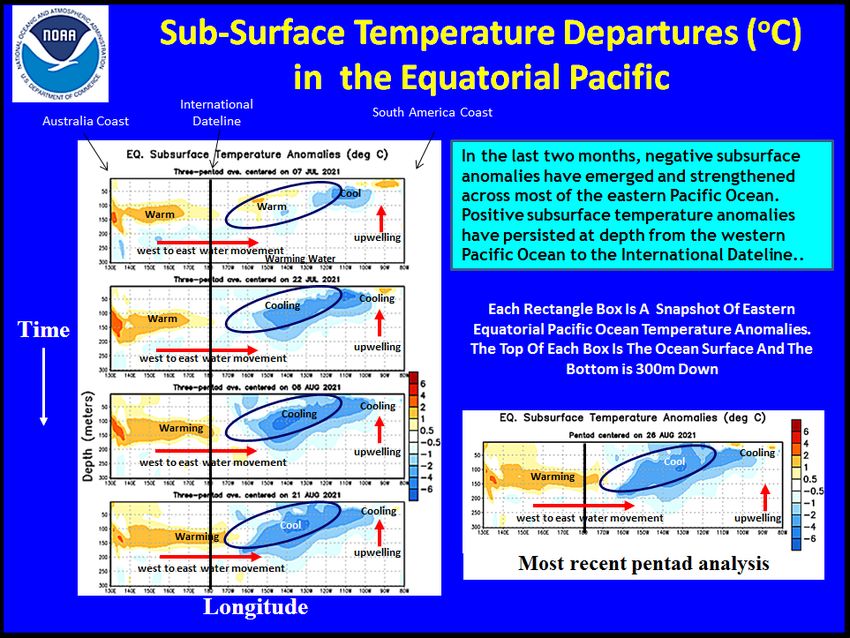
V O L U ME X I I I, ISS UE X T HE C A NAD I A N AG R IC U LTU RE WE AT HER PR OG NOS T IC AT OR PAGE 8
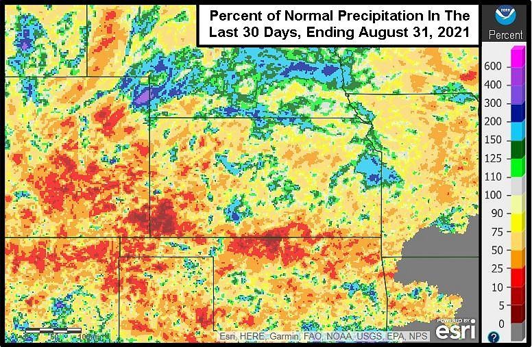
U.S. Dryness Could Become An Issue For Wheat
August was unusually dry across planting begins. Rain will move through western
much of the Hard Red Winter Wheat production areas of the Hard Red
Region. The drier bias was not just Some early autumn planting is Winter Wheat Region today with
confined to August, but was also not- about to begin in the southwestern some pockets of significant rain oc-
ed in portions of the region during part of the Hard Red Winter Wheat curring late in the day through Fri-
June and July. As a result, of the dri- Region and greater rainfall would be day. Some erratic showers and
er bias this summer and some persis- beneficial for this due to the low top- thunderstorms will then linger in
tent warm to hot weather in August, soil moisture. The good news is that southern parts of the wheat region
top and subsoil mois- greater rainfall is expected today into into Saturday and
ture is rated short to Sunday. Total rain
very short in many through Sunday will
hard red winter wheat vary from 0.35 to 1.50
areas. inches in the region.
The wettest areas will
A culmination of likely be from the Ok-
anomalous weather lahoma Panhandle,
trends are coming to- northwestern Texas
gether this autumn Panhandle, and far
and winter to suppress southeastern Colora-
rainfall and the dry- do through central
ness already present Kansas. Some local
in the region could end totals in central Kan-
up expanding greatly sas will be greater
over the next few than 2.00 inches. This
months. Drought in rain will help support
the region is expected germination in early
to return and concern planted wheat fields
over the emergence, in the southwest.
establishment and
production potential The rain this week
for unirrigated winter will be beneficial;
wheat in the region however, there is con-
will be rising as well. cern of a drier trend
Some of this dryness is later in September
expected to reach into and October when
the western Corn Belt most of the winter
over time. wheat planting oc-
curs. After this week’s
The dryness and precipitation passes, a
warm to hot tempera- much drier weather
tures in August has pattern will evolve
led to a majority of the and temperatures will
wheat region to have rise above normal.
short to very short soil Saturday due to a frontal boundary The drier and warmer weather bias
moisture. The only exceptions are in and a couple of weather disturbances. should become a persistent feature
areas that have recently received These weather disturbances will pull during the balance of this month
heavier rainfall, but as noted earlier some monsoon and remnant moisture and into October. Moisture that has
the greatest rainfall was a little from Hurricane Nora into the central been feeding into the region from
blotchy across the region and the ma- Plains from the southwestern states the southwestern states (monsoon
jority of crop areas will have need for enhancing rainfall briefly. moisture) is ending. Rain will not
significant rain this autumn before fall as often or as significantly in
World Weather, Inc. forecasts and comments pertaining to present, past and future weather conditions included in this report constitute the corporation's judg-
ment as of the date of this report and are subject to change without notice. Comments regarding damage or the impact of weather on agricultural and energy as
well as comments made regarding the impact of weather on the commodity and financial markets are the explicit opinions of World Weather, Inc. World Weath-
er, Inc. can not be held responsible for decisions made by users of the Corporation's information in any business, trade or investment decision.
©2021 World Weather, Inc. Any unauthorized redistribution, duplication or disclosure is prohibited by law and will result in prosecution. [913-383-1161]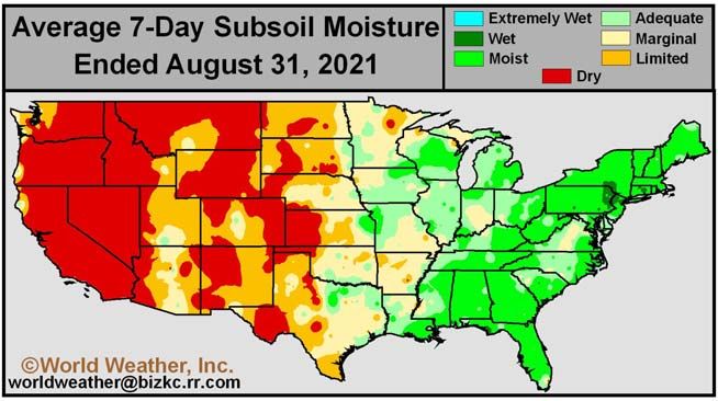
VOLU ME X III, ISS UE X                  T HE C A NAD I A N AG R IC U LTU RE WE AT HER PR OG NOS T IC AT OR                                            PAGE 9

  U.S. Plains Dryness May Be A Wheat Issue (Continued From Page 8)
the central or southern Plains over                    during those months tend to down-                      than usual in September and Octo-
the next few weeks as that of the past                 play rainfall in hard red winter                       ber. The most anomalously warm
few weeks; although, a few showers                     wheat areas. The 18-year cycle will                    weather is expected in October
will occur infrequently as frontal sys-                promote a northwesterly wind flow                      mainly because late September
tems move across the region.                           pattern aloft during the late autumn                   temperatures could drop below av-
                                                       and winter which also matches the                      erage for a little while. The October
   La Nina is expected to develop                      bias that comes from La Nina. That                     warm and dry weather will produce
later this month and become greater                    will likely result in further support                  some aggressive drying at the time
influence on world weather during                      for below average precipitation.                       in which aggressive planting of
the October through February period.                                                                          wheat is normally occurring. As a
Most La Nina events that are in place                      Temperatures will be warmer                        result, soil moisture will be low and
                                                                                                              decreasing further when crops are
                                                                                                              planted and unirrigated fields may
                                                                                                              experience some delay in planting
                                                                                                              or (and more likely) there will be a
                                                                                                              delay in germination, emergence
                                                                                                              and establishment.

                                                                                                                  The drier bias in the Plains will
                                                                                                              prevail into winter and early spring
                                                                                                              raising much concern amount the
                                                                                                              fate of this year’s crop. Many La
                                                                                                              Nina events end in the early spring
                                                                                                              and rainfall often kicks in rather
                                                                                                              significantly during the middle to
                                                                                                              latter part of spring saving crops
                                                                                                              after prolonged drier bias. 2022
                                                                                                              spring rainfall could be hindered by
                                                                                                              a delayed break down in La Nina
                                                                                                              and/or by the negative phase of
                                                                                                              PDO and the prevailing 18-year
                                                                                                              cycle.

                                                                                                                  World Weather, Inc. has written
                                                                                                              before about the potential for a mul-
                                                                                                              ti-year drought in North America
                                                                                                              because of the solar cycle and some
                                                                                                              other coincidental weather patterns
                                                                                                              and we still believe that to be true.
                                                                                                              There is reason to believe that late
                                                                                                              spring weather next year may not
                                                                                                              be as good as it should be in the
                                                                                                              central U.S. and by that time dry-
                                                                                                              ness will have spread from the
                                                                                                              Plains into the western Corn Belt
                                                                                                              raising worry not only about hard
                                                                                                              red winter wheat production, but
                                                                                                              also over the planting and early
                                                                                                              development prospects for 2022
                                                                                                              corn and soybeans.

World Weather, Inc. forecasts and comments pertaining to present, past and future weather conditions included in this report constitute the corporation's judg-
ment as of the date of this report and are subject to change without notice. Comments regarding damage or the impact of weather on agricultural and energy as
well as comments made regarding the impact of weather on the commodity and financial markets are the explicit opinions of World Weather, Inc. World Weath-
er, Inc. can not be held responsible for decisions made by users of the Corporation's information in any business, trade or investment decision.

©2021 World Weather, Inc. Any unauthorized redistribution, duplication or disclosure is prohibited by law and will result in prosecution. [913-383-1161]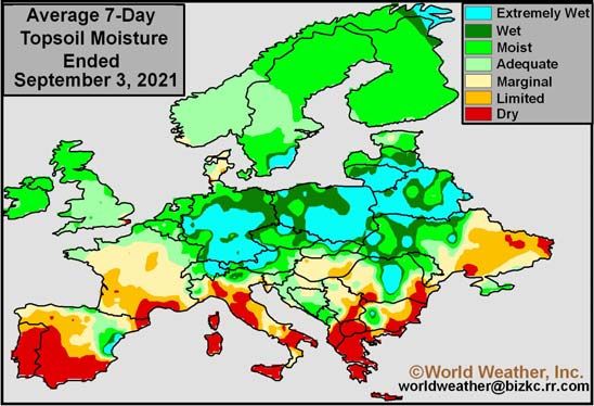
You can also read