Resilience Assessment Framework Tool - RAF APP - Description and implementation Authors: P.Lopes, R. Martins, A. Oliveira, M.A. Cardoso, RESCCUE
←
→
Page content transcription
If your browser does not render page correctly, please read the page content below

Ref. Ares(2020)1000724 - 17/02/2020

Resilience Assessment Framework
          Tool - RAF APP
     Description and implementation
  Authors: P.Lopes, R. Martins, A. Oliveira, M.A. Cardoso,
                   R.S. Brito, C. Pereira
                     Affiliation: LNEC
                 Date: 31 October 2019
RESCCUE - RESilience to cope with Climate Change in
Urban arEas - a multisectorial approach focusing on water
Grant Agreement no.700174.

 DELIVERABLE NUMBER:                       D6.5

                                           Resilience Assessment Framework Tool – RAF
 DELIVERABLE NAME:
                                           APP

 WP:                                       WP6

 DELIVERY DUE DATE:                        31/10/2019

 ACTUAL DATE OF SUBMISSION:                01/11/2019

 DISSEMINATION LEVEL:                      Public

 LEAD BENEFICIARY:                         LNEC

 RESPONSIBLE                               Maria Adriana Cardoso
 SCIENTIST/ADMINISTRATOR:

                                           Pedro Lopes, Ricardo Martins, Anabela Oliveira,
 AUTHOR(S):                                Maria Adriana Cardoso, Rita Salgado Brito,
                                           Cristina Pereira – LNEC

 CONTRIBUTOR(S):

 INTERNAL REVIEWER:                        Maria Rafaela Matos

 EXTERNAL REVIEWER:                        Sozvin Salih

    Document history
 DATE          VERSION    AUTHOR                  COMMENTS

 15/09/2019    1.0        Pedro Lopes (LNEC)      First version of the deliverable

                          Maria Adriana
 20/09/2019    1.1                                First revision of the deliverable
                          Cardoso (LNEC)

                          Maria Adriana
 20/10/2019    1.2                                Revision of the internal and external reviewers
                          Cardoso (LNEC)

                          Maria Adriana
 1/11/2019     Final                              Final version of the document
                          Cardoso (LNEC)

    1. Changes with respect to the DoA

    This deliverable was not initially defined in the DoA. Following the work
    developed in WP6 it was approved in the Amendment No. AMD-700174-21.

2
2. Dissemination and uptake
   Public (PU). The report is fully open and will be distributed through the web.
   The web-based tool requires registration.

   3. Short Summary of results (
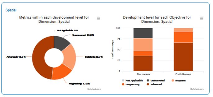
Table of contents
Summary Figures ............................................................................................................................. 5
1.       Introduction ............................................................................................................................. 1
     1.1.       Background ....................................................................................................................... 1
     1.2.       Access to the RAF App .................................................................................................. 2
2.       RAF App overview ................................................................................................................. 2
     2.1.       Tool and methodology .................................................................................................. 2
     2.2.       Creating a new study ..................................................................................................... 3
     2.3.       Dimensions ....................................................................................................................... 4
     2.4.       Results ................................................................................................................................ 5
3.       Conclusions ............................................................................................................................... 7
Bibliography....................................................................................................................................... 8
Annexes................................................................................................................................................ 9
Annex 1 – RAF App User guide ................................................................................................ 11
Resilience Assessment Framework application – RAF APP – User guide ........................ 13
Overview ............................................................................................................................................ 13
Login.................................................................................................................................................... 14
Studies ................................................................................................................................................ 14
City main page.................................................................................................................................. 15
     Upper bar...................................................................................................................................... 15
     4.1 City Location ......................................................................................................................... 15
     4.2 Dimension tabs .................................................................................................................... 18
Final notes ......................................................................................................................................... 24

4
Summary Figures

Figure 1 – Access to the RAF App .............................................................................................. 2
Figure 2 – City main page in the RAF App .............................................................................. 3
Figure 3 – City main page: City Profile tab ............................................................................. 3
Figure 4 – City main page: Service Profile tab ...................................................................... 4
Figure 5 – Example of data insertion in the RAF App, by dimensions ........................ 4
Figure 6 – RAF App results: city overall – metrics within each development level
           in the city ...................................................................................................................... 5
Figure 7 – RAF App results: city overall by dimension ..................................................... 5
Figure 8 – RAF App results: example of a city disaggregated assessment ................ 6
Figure 9 – RAF App results: example of a city detailed assessment ............................ 6
Figure 10 – RAF App results: example of a city integrated resilience progress on a
           given time interval .................................................................................................... 7

                                                                                                                                           v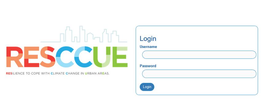
1. Introduction
1.1. Background
This document is developed as part of RESCCUE (RESilience to cope with Climate
Change in Urban arEas - a multisectorial approach focusing on water) project,
which has received funding from the European Union’s Horizon 2020 Research
and Innovation program, under the Grant Agreement number 700174.
The Resilience Assessment Framework Tool – RAF APP description corresponds
to Deliverable 6.5 of Work Package 6 (WP6) – Validation Platform and First
Applications. WP6 promotes the development of a roadmap for resilience to
climate change-related events in the RESCCUE cities – Barcelona, Lisbon and
Bristol – having the urban water cycle in the core, based on the RESCCUE
developments and on the drivers, opportunities, context, existing practices and
knowledge of each city. Each city selected relevant critical hazards being those
associated with urban flooding common to all of them. The specific objectives of
WP6 include:
to carry out a structured resilience diagnostic in each city, for the domains
selected to all case study areas;
to review the cities resilience diagnostic, identifying opportunities for
improvement in each city and sharing cases already implemented in the
cities;
to contribute to the Resilience Action Plans complementing as appropriate,
based on the resilience strategies and existing relevant information
produced in each city;
to learn and share the results in order to maximize RESCCUE impact; and
to produce generic guidelines targeted to any other cities based on the
learnings and outcomes of the demonstration in the RESCCUE cities.
The RAF App is to be used within the project to support the development of the
Resilience Action Plans (RAP) by the RESCCUE cities and by all partners involved.
It is also intended to be used by any city, service or organization that aims to
undertake a city or service resilience assessment to climate change (CC) with focus
on water or to develop a RAP. This document represents the written output of the
development the Resilience Assessment Framework tool – RAF App. Together
with the RAF framework (Cardoso et al., 2019); it completes the set of deliverables
regarding resilience assessment in WP6.
1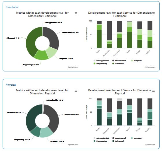
1.2. Access to the RAF App
Please find below the information to access to the RAF App:

URL: https://resccue.lnec.pt
User: Ext_review
Password: r8v_resC)cueT2019

In case any difficulties arise, please contact macardoso@lnec.pt
(Registration is required before accessing the app through the email above)

2. RAF App overview
2.1. Tool and methodology
The RESCCUE RAF App materializes the Resilience Assessment Framework (RAF)
developed in D6.4 (Cardoso et al., 2019) in a user-friendly web interface. It
provides an evaluation of city and urban services resilience to Climate Change
(CC), including multi-sector interdependencies. The information provided by this
tool empowers city and urban services managers with an assessment, allowing to
know where they stand and to identify the resilience gaps, thus supporting
decision on the most advantageous investments for the city and services and
planning to cope with future CC challenges.

Access to the application is made using credentials given upon request, to ensure
data confidentiality. A users’ manual for the RAF App was developed and is
accessible from the platform, and is included as an annex of this deliverable. This
web-based platform tool was developed in order to support the RAF usage and
includes the entire developed framework that is described in detail in Cardoso et
al. (2019).

The following sections describe the steps to be followed by a RAF App user, after
access (Figure 1).

                             Figure 1 – Access to the RAF App

2
2.2. Creating a new study
The RAF is designed to be answered for an integrated assessment of the city and
its services, for a given time period and for a specific hazard – this is considered
as a study. While creating a new study for assessment, in the city main page
(Figure 2), the user has to specify the dimensions (organisational, spatial,
functional and physical) and also the services (water, wastewater, stormwater,
waste, energy and mobility) to assess within the functional and physical
dimensions. For the selected dimensions and services, subsequent tabs will
display the correspondent RAF structure.
Figure 2 – City main page in the RAF App
Before getting into data input for resilience assessment, a section regarding the
city and services profile is available (Figures 3 and 4).
Figure 3 – City main page: City Profile tab
3Figure 4 – City main page: Service Profile tab
2.3. Dimensions
For each selected dimension, the app allows to navigate into the correspondent
RAF structure (objectives, criteria and metrics).
To facilitate and plan the introduction of responses for each metric, within each
dimension, the platform allows to select a certain set of metrics, that may
correspond to a given criteria, objective or to a given metrics’ relevance. The
correspondent metrics are then displayed and the set of metrics with the
respective pre-defined answers opens for selection and inputs. An example is
presented in Figure 5.
Figure 5 – Example of data insertion in the RAF App, by dimensions
42.4. Results
The RESCCUE RAF App includes a module to graphically explore the results,
allowing for a user-friendly and dynamic visualization. This is also possible for the
level of aggregation selected by the user, such as for the whole city (Figure 6 and
7), for a given dimension, service (Figure 8), objective or criteria, or for a given
level of metrics’ relevance or analysis level (Figure 9).
In every graph within the results tab, the colour translates what is under
assessment. The blue corresponds to city integrated assessment, and every other
different colour corresponds to a resilience dimension (red for organisational,
orange for spatial, bright green for functional and petroleum green for physical).
The different tones within each colour correspond to the development level of the
metric’s answer: advanced, progressing or incipient. Darker tones relate to the
percentage of metrics with an advanced development level, medium tones to
progressing and lighter to incipient. Dark grey relates to unanswered metrics and
light grey to metrics that are not applicable to the city or service.
Figure 6 – RAF App results: city overall – metrics within each development level in the city
Figure 7 – RAF App results: city overall by dimension
5a) Metrics within each development
b) Development levels for each service in the physical dimension
level in the physical dimension
Figure 8 – RAF App results: example of a city disaggregated assessment
a) Energy service: metrics in the criterion “preparedness for CC”
b) Development level for each metric in this c) Metric within this criterion
criterion
Figure 9 – RAF App results: example of a city detailed assessment
Visual comparison between different evaluation moments in time, for the same
city, is available. The RAF App allows monitoring resilience progress in a given
6time window, both by visually comparing the diagnosis in different years (Figure
10) and by identifying the progress through variation of the percentages for each
development level.
This tool also allows to visualise the expected resilience development level, if the
measures adopted by the city are implemented in a given planning horizon, by
graphically illustrating the effect on the result of the metrics that were affected by
the measures (in each criterion, objective, service or dimension).
a) 2014 assessment b) 2019 assessment
Figure 10 – RAF App results: example of a city integrated resilience progress on a given time interval
Finally, the tool provides an output in a pre-defined summary report, highlighting
the most relevant graphs. Stored data can be easily analysed and extracted for
further analysis.
These results support the city and services managers in making effective decisions
to plan city resilience enhancement.
3. Conclusions
In summary, as a tool that explores RAF architecture, the RAF App:
facilitates the use of the RAF framework;
supports assessment, diagnosis and decision-making;
monitors the progress of a city or service;
compares different services;
7 addresses the contribution of urban services to the city's resilience to
climate change;
acknowledges improvement opportunities to increase resilience;
supports the development of resilience plans;
facilitates communication between stakeholders.
The RAF App demonstrated to be a worthy solution to uptake the contributions
from the cities, since it is a user-friendly tool facilitating metrics’ inputs and
providing an easy visualization of results by graphical aggregation, as well as a
first identification of resilience strengths, gaps and improvement opportunities.
Given its importance, generic nature and flexible structure, the RESCCUE RAF App
can be extended to other cities and, in the future, to other urban services or
hazards.
Bibliography
Brito, R.S., Pereira, C.L., Lopes, P., Cardoso, M.A. (2019). RESCCUE RAF App - Climate change
Resilience Assessment Framework tool for urban areas. ECCA 2019, European Climate
Change Adaptation Conference, Lisbon, Portugal.
Cardoso, M.A., Brito, R.S, Pereira, C., David, L., Almeida, M.C. (2019). Resilience Assessment
Framework RAF. Description and implementation. Deliverable of the H2020 Project
RESCCUE, Grant Agreement no.700174.
Lopes, P., Oliveira, A., Pereira, C., Brito, R.S., Cardoso, M. A., Martins, R., David, M., Gomes, J., Pina, J.
(2019). RESCCUE RAF app – an IT solution for digital interactive urban resilience assessment.
10th Iberian Grid Conference, 23 September, Santiago de Compostela, Spain.
8Annexes
910
Annex 1 – RAF App User guide

                               11
12
Resilience Assessment Framework
application – RAF APP – User guide

Contents

Summary Figures
1.     Introduction
     1.1.   Background
     1.2.   Access to the RAF App
2.     RAF App overview
     2.1.   Tool and methodology
     2.2.   Creating a new study
     2.3.   Dimensions
     2.4.   Results
3.     Conclusions
Bibliography
Annexes
Annex 1 – RAF App User guide
Resilience Assessment Framework application – RAF APP – User guide
Overview
Login
Studies
City main page
     Upper bar
     4.1 City Location
     4.2 Dimension tabs
Final notes

Overview
This tool provides a framework to assess urban resilience to climate change, with focus on
water, considering an objective-oriented approach and four resilience dimensions:
organisational, considering governance relationships; spatial, covering urban space and
environment; functional, focused on strategic services in the city (water, wastewater,

                                                                                      13
stormwater, waste, energy and mobility); and physical, centred on infrastructure of these
services. The resilience objectives are described through key criteria (expressing different
points of view), which are evaluated by metrics. In this given scope, the metrics are described
and associated to reference values, providing a user-friendly assessment to support a
structured diagnosis. The app allows the use of a defined structure based on dimensions /
objectives /criteria / metrics, specifically designed to address the referred scope.
The app can be used as a tool to support assessment, diagnosis and decision-making as well
as the development of resilience plans, to monitor progress of a city or service or to compare
different parts of the cities or services.
Login
A user with credentials can login into the RAF App.
Studies
After a successful login, the user will be redirected to the studies page, containing all his
previously saved studies (for the city and year that the user has previously created or has been
assigned access).
In this page the user can manage his previously saved studies:
Create study: create a new study for the city or for another city
Edit study: fill and change city information
Clone city: make a copy of the study, e.g. for the city information in a previous year
Check the city report: a summary of study results available for download
Delete studies
14If the city wants to assess different hazards existing in the city, different studies must be
created. One study for each hazard.
For this, after creating a study and completing the assessment considering one selected
hazard, the user has to clone the study already completed to assess a new hazard, giving a
new name and editing only the hazard-related metrics. In case there is a service with no
assessment for that hazard the user deselects the respective service in the RAF app - city
location page - for the functional and physical dimensions.
For each study, the hazard under assessment needs to be identified and described in the City
and Service profiles, in the hazard section.
However, for each hazard the user may have different variables.
So, when answering to the metrics of the scenarios (e.g., MP or MS) for one hazard (e.g.
flooding), if there are differences regarding the impacts/consequences that depend on the
type of variable, then the answer shall be done for the variable that causes the most serious
consequence, and shall be indicated the variable in the comments. In this situation, it is still
possible to create a different study for each variable if it deepens the assessment and
facilitates the identification of solutions. However, it is not recommended in order to keep
parsimony.
City main page
Upper bar
The city main page can be accessed when creating a new study or when editing a previously
created study.
At the upper bar, the user has two fixed options:
go back to studies
open the App user guide (this document)
The top of the page also presents the navigation bar, where the user can select where to go
next. This bar contains the main App structure: City location, the four dimensions, and the
results.
154.1 City Location In City Location the user has a tab with General information, City Profile and Service Profile. The General contains generic information about the city: city name, year of the study, a map (where the user can select the city to originate coordinates), the dimensions under assessment (organisational, spatial, functional and physical) and the services that are being assessed (water, wastewater, stormwater, waste, energy and mobility) within the functional and physical dimensions. At this stage, the user has to select which dimensions and services are being assessed in the study of the city. If a dimension is selected at this stage, it will become available to access through the navigation bar and to explore the corresponding results in the end of the navigation bar. In a similar way, if a service is selected at this stage, it will appear available when entering the functional or physical dimension, whichever applicable, and also available to explore the corresponding results. In case of combined sewer systems, both wastewater and stormwater services need to be selected and answered for the applicable metrics. Those metrics that are not applicable have to be duly identified. City profile contains information relevant for understanding the city context and the results of the resilience assessment. The information in city and service profile is the starting point for the assessment, with some metrics where the user has to specify what will be considered in the assessment. 16
In this section, the city context is presented in several boxes (Geographical characteristics,
Climate, Population, Economy & governance and Built environment & infrastructures). The
available fields have some guidelines in grey, and a button (           ) to look for more
details/explanations.

In the Climate box, some fields, when selected, unfold into other fields to complete. E.g.: if
the user has data about some of the presented variables (temperature and rainfall), when
selecting, more fields will unfold to complete with detailed data. Any comments should be
provided in the answer field.

In the Hazards section, the selected hazards are numbered and unfold into a table with
variables. A value with the same units used above (Climate and environment variables section)
should be provided.

                                                                                          17
In the last box (Assessment scope), the user has to select the numbers correspondent to the selected hazards (Hazards section). In Service profile, first the user has to select the service(s) to be assessed. For this, relevant information to both service and service infrastructure is presented. For most of the metrics, there are four fields to be completed by the utilities in charge. If the service is managed by a single utility, only the Utility 1 field should be used. 4.2 Dimension tabs In the tab inside each selected dimension, a box with a dropdown menu is available (Objective and criteria box). This is where the user may select the criterion within the objective to be assessed. Once the criterion is selected, the corresponding objective will appear above. 18
The table that is displayed (see above picture) shows the metrics included in the selected
criterion. A table with all the metrics within the dimension is available when selecting ALL in
dropdown menu in the Objective and criteria box.
When this option is selected (ALL), a Search box is available to find a specific metric through
some keywords.
Each metric has a reference number (left column), a given name (performance indicator, PI)
and question, additional information (+info) and boxes for the city answer, additional
comments or specifications in case the metric does not apply.
The user can filter the metrics by importance, to assess a specific set of metrics. Metrics
importance can be:
Essential: Integrates any city assessment, applicable to any city.
Complementary: Integrates evaluation of specific or detailed city aspects.
Comprehensive: To a comprehensive assessment of the city, may not be applicable
to all cities
As metrics importance reflects an in deeper assessment path, a sequential inclusion of metrics
is done when using the importance filter (box with a drop down menu):
When selecting the Essential (E) filter, the user sees only the metrics with a
performance indicator (PI) classified as E.
When selecting the Complementary (C) filter, the user sees the metrics with a PI
classified as E and C.
When selecting the Comprehensive (CH) filter the user sees all metrics.
19The user can find the information above selecting
Each metric has also an for the metric explanation (in the +info column).
There are three types of metrics to answer:
Metrics with only one answer option to pick (“select option”)
Metrics with multiple options to pick (“select all applicable”)
Metrics to answer with an estimated figure (open field)
All metrics have the option “Not applicable in the city, explain why in comments.” and a box
to insert additional comments is provided.
In case no option is selected, a dropdown menu (the Specify why box) is available to specify
the reason why the metric is not answered.
This framework has some metrics that precede other i.e. condition the existence of others.
The conditioning relation between metrics is available in the annex of this manual.
When answering any of the metrics that condition others, verify whether the answer that you
provide conditions the possibility of the dependent metrics to be answered. In such case,
ensure the respective dependent metrics are answered as Not Applicable. See example below.
In this case, if the answer for metric 33 is yes, the dependent metric (34) must be answered.
If the answer is no, the dependent metric will be considered as Not Applicable (this option
must be selected).
Specifically, in Functional and Physical dimensions, firstly the service(s) to assess must be
chosen.
Before moving to other dimension or to the results tab, it is recommended to save your data
by clicking in SAVE button, at the top right corner
Results
Depending on the answers to the metrics, each metric/criteria/objective/dimension is
classified with a development level: Advanced, Progressing or Incipient.
Advanced
Progressing
20
Incipient Advanced metrics are those with higher development level, identified in graphs with
a darker color.
Progressing metrics have an intermediate development level and are identified in
graphs with a color between the darker and the lighter.
Incipient metrics have a lower development level and are identified in graphs with a
lighter color.
The first section presents the overall results, gathering all dimensions’ results. The user can
see the overall city results in two charts (as % of all metrics of the assessment):
Metrics in advanced, progressing or incipient level considering all resilience
dimensions in the city, and also the unanswered and not applicable metrics (donut
graph)
Metrics in each development level by dimension (bar graph)
21In City Report, the user can get a summary of city results (overall city results and overall results by dimension). The pdf file is available to download. 22
The user can choose to see more detailed results entering each dimension and using the
available filters.
By selecting one dimension it is possible to see the results by service (if previously chosen for
assessment), objective, criteria, importance and level.
The assessment level can be
Strategic: metrics associated with higher level of decision making in the city
and long term view decisions;
Tactical: metrics associated with intermediate decision making and
implementation levels in the city and medium term view decisions.
Either in overall or within one dimension, it is possible to compare the current study results
with another study (e.g. the same city in a previous year) using the option “Compare with”.
In each dimension, the user may ask for the correspondent metrics table. This table will
present all metrics within the dimension, the correspondent city answers and the associated
23development level. This metrics table is available to download (.xls file). The user can export
any chart or table selecting .
Graph types are the same when selecting results within each dimension:
Organisational: overall dimension (donut) and results by objectives (bar
graph)
Spatial: overall dimension (donut) and results by objectives (bar graph)
Functional: overall dimension (donut) and results by services (bar graph)
Physical: overall dimension (donut) and results by services (bar graph)
The user can cascade down, into more detail. For instance, when selecting results by objective,
the graphs display the results for the overall objective (donut) and by criteria (bar graph).
When the user is in the most detailed display of the results, i.e., selecting results by criteria,
the graphs shows the overall criteria with a new graph type (spider graph for every metric
within the criteria).
Specifically in this graph, when the user moves the mouse around, the metric’s development
level is presented in a box along with the metric’s performance indicator (PI).
As in the other graphs, the spider graph also has an associated table with detailed information
about the metrics within the selected criteria.
Final notes
To keep the changes made by the user, it is recommended to SAVE before leaving to “studies”
or to select the “Results” tab in the Navigation Bar, otherwise everything changed by the user
will not be recorded:
Data will be temporarily kept when the user edits the answers and skips between
dimension tabs without saving;
The user should Save when skipping between objectives or dimension tabs, if the
user really wants to save permanently those changes.
The user should be aware that skipping to the “Results” tab will save automatically all the
changes made. If the user wants to exit the study and discard the changes:
The user should not move to “Results” neither use the Save button;
The user should move directly to Studies.
24Either in the dimensions or in results tabs, the back button will always redirect the user to City
Location.
Metrics dependencies
Organisational Spatial
Metrics Dependencies Metrics Dependencies
O17 S01 (if yes) S02
O16 (if 3/2/1 selected)
O18 S09 (if yes) S10
O25 S14 (if 3 or 2 or 1 selected) S15
O26 S22 (if yes or partially) S23, S24
O24 (If 3 or 2 selected) O27
O28
O29
O38 (if yes) O39
O30 (if 3/2/1 selected) O36, O40, O46, O48
O44 (if yes) O45
O52
O51 (if yes)
O53
O58 (if 3/2/1 selected) O59, O60
O63 (if yes) O64
S06, S07, S08, S09, S16, S17, S27, S28;
FMob12, FMob13, FMob14, FMob15,
O54 organisational (if 3/2/1
FMob16, FMob17, FMob35, FMob36,
selected)
FMob38, FMob39,FMob40, FMob41,
FMob42
Functional - Water Functional - Wastewater
Metrics Dependencies Metrics Dependencies
FWts02 FWwt02
FWts01 (if yes/partially) FWwt01 (if yes/partially)
FWts03 FWwt03
FWts06 (if yes) FWts07 FWwt06 (if yes) FWwt07
FWts56 (if 3/2/1 selected) FWts57 FWwt53 (if 3/2/1 selected) FWwt54
FWwt14, FWwt15, FWwt16, FWwt17,
FWts14, FWts15, FWts16, FWts17, FWwt18, FWwt19, FWwt20, FWwt21,
FWts18, FWts19, FWts20, FWts21, FWwt38, FWwt39, FWwt46, FWwt55,
FWts22, FWts23, FWts41, FWts42, FWwt56, FWwt57, FWwt58, FWwt59,
FWts48 (if 3/2/1 selected) FWts49, FWts58 to FWts67; PWts20, FWwt45 (if 3/2/1 selected) FWwt60, FWwt61, FWwt62, FWwt63;
PWts36, PWts37, PWts38, PWts41, PWwt20, PWwt35, PWwt36, PWwt37,
PWts42, PWts43, PWts44, PWts45, PWwt40, PWwt41, PWwt42, PWwt43,
PWts46, PWts47, PWts48, PWts49 PWwt44, PWwt45, PWwt46, PWwt47,
PWwt48
Functional - Stormwater Functional - Waste
Metrics Dependencies Metrics Dependencies
FSwt02 FSlw02
FSwt01 (if yes/partially) FSlw01 (if yes/partially)
FSwt03 FSlw03
FSlw06 (if yes) FSlw07
FSwt06 (if yes) FSwt07
FSlw51 (if 3/2/1 selected) FSlw52
FSlw14, FSlw15, FSlw16, FSlw17, FSlw18,
FSlw19,FSlw20, FSlw36, FSlw37, FSlw44,
FSlw53, FSlw54, FSlw55, FSlw56, FSlw57,
FSwt46 (if 3/2/1 selected) FSwt47 FSlw43 (if 3/2/1 selected) FSlw58, FSlw59, FSlw60; PSlw18, PSlw35,
PSlw36, PSlw37, PSlw40, PSlw41, PSlw42,
PSlw43, PSlw44, PSlw45, PSlw46, PSlw47,
PSlw48
FSwt14, FSwt15, FSwt16, FSwt17, FSwt18,
FSwt31, FSwt32, FSwt39, FSwt48, FSwt49,
FSwt50, FSwt51, FSwt52; PSwt20,
FSwt38 (if 3/2/1 selected)
PSwt35, PSwt36, PSwt37, PSwt40,
PSwt41, PSwt42, PSwt43, PSwt44,
PSwt45, PSwt46, PSwt47, PSwt48
25Functional - Energy Functional - Mobility
Metrics Dependencies Metrics Dependencies
FEne02 FMob02
FEne01 (if yes/partially)
FEne03 FMob03
FMob01 (if existing) FMob06
FEne06 (if yes)
FEne07 FMob07
FEne46 (if 3/2/1 selected) FEne47 FMob08
FEne14, FEne15, FEne16, FEne17,
FEne18, FEne31, FEne32, FEne39,
FEne48, FEne49, FEne50, FEne51,
FEne38 (if 3/2/1 selected)
FEne52; PEne16, PEne30, PEne31,
PEne32, PEne35, PEne36, PEne37,
PEne38, PEne39, PEne40, PEne41
Physical - Water Physical - Wastewater
Metrics Dependencies Metrics Dependencies
PWts02 PWwt02
PWts01 (if yes/partially) PWts03 PWwt01 (if yes/partially) PWwt03
PWts04 PWwt04
PWts01 (if yes/partially) PWts36, PWts47 PWwt01 (if yes/partially) PWwt35, PWwt46
Physical - Stormwater Physical - Waste
Metrics Dependencies Metrics Dependencies
PSwt02 PSlw02
PSwt01 (if yes/partially) PSwt03 PSlw01 (if yes/partially) PSlw03
PSwt04 PSlw04
PSwt01 (if yes/partially) PSwt35, PSwt46 PSlw01 (if yes/partially) PSlw35, PSlw46
Physical - Energy Physical - Mobility
Metrics Dependencies Metrics Dependencies
PEne02 PMob02
PEne01 (if yes/partially) PEne03 PMob01 (if yes/partially)
PMob03
PEne04
PEne01 (if yes/partially) PEne30, PEne39 PMob01 (if yes/partially) PMob24
2627
Organisational         Spatial
     Old REF NEW REF             Old REF   NEW REF
           1 O01                   100a    S01
           2 O02                   100b    S02
           3 O03                     101   S03
           4 O04                     102   S04
           5 O05                     103   S05
           6 O06                     104   S06
           7 O07                     105   S07
           8 O08                     106   S08
           9 O09                   107a    S09
          10 O10                   107b    S10
          12 O11                    107c   S11
          13 O12                     108   S12
          14 O13                     109   S13
          15 O14                     110   S14
          16 O15                     111   S15
         17a O16                     114   S16
         17b O17                     115   S17
         17c O18                     118   S18
          18 O19                     119   S19
          19 O20                     120   S20
          20 O21                     121   S21
          21 O22                     122   S22
          22 O23                     123   S23
         23a O24                     124   S24
         23b O25                     125   S25
         23c O26                     126   S26
         23d O27                     127   S27
          24 O28                     128   S28
          25 O29                     129   S29
          26 O30
          27 O31
          28 O32
          29 O33
         30a O34
         30b O35
          31 O36
          32 O37
          33 O38
          34 O39
          35 O40
          36 O41
          37 O42
          38 O43
         39a O44
         39b O45
          40 O46
          41 O47
          42 O48
         43a O49
         43b O50
         44a O51
         44b O52
         44c O53
          45 O54
          97 O55
          98 O56
          99 O57
          49 O58
          50 O59
         51a O60
         51b O61
          52 O62
         53a O63
         53b O64
          54 O65
         55a O66
         55b O67
         56a O68
         56b O69
          57 O70
          58 O71
          59 O72
          60 O73
          61 O74

28
Functional Functional Functional Functional Functional Functional
WATER WASTEWATER STORMWATER WASTE ENERGY MOBILITY
Old REF NEW REF Old REF NEW REF Old REF NEW REF Old REF NEW REF Old REF NEW REF Old REF NEW REF
300 FWts01 400 FWwt01 500 FSwt01 600 FSlw01 700 FEne01 800 FMob01
301 FWts02 401 FWwt02 501 FSwt02 601 FSlw02 701 FEne02 801 FMob02
302 FWts03 402 FWwt03 502 FSwt03 602 FSlw03 702 FEne03 802 FMob03
303 FWts04 403 FWwt04 503 FSwt04 603 FSlw04 703 FEne04 803 FMob04
304 FWts05 404 FWwt05 504 FSwt05 604 FSlw05 704 FEne05 804 FMob05
305 FWts06 405 FWwt06 505 FSwt06 605 FSlw06 705 FEne06 805 FMob06
306 FWts07 406 FWwt07 506 FSwt07 606 FSlw07 706 FEne07 806 FMob07
307 FWts08 407 FWwt08 507 FSwt08 607 FSlw08 707 FEne08 807 FMob08
308 FWts09 408 FWwt09 508 FSwt09 608 FSlw09 708 FEne09 809 FMob09
309 FWts10 409 FWwt10 509 FSwt10 609 FSlw10 709 FEne10 810 FMob10
310 FWts11 410 FWwt11 510 FSwt11 610 FSlw11 710 FEne11 811 FMob11
311 FWts12 411 FWwt12 511 FSwt12 611 FSlw12 711 FEne12 812 FMob12
312 FWts13 412 FWwt13 512 FSwt13 612 FSlw13 712 FEne13 813 FMob13
313 FWts14 413 FWwt14 513 FSwt14 613 FSlw14 713 FEne14 814 FMob14
314 FWts15 414 FWwt15 515 FSwt15 614 FSlw15 715 FEne15 819 FMob15
315 FWts16 415 FWwt16 517 FSwt16 615 FSlw16 717 FEne16 820 FMob16
316 FWts17 416 FWwt17 519 FSwt17 617 FSlw17 719 FEne17 821 FMob17
317 FWts18 417 FWwt18 521 FSwt18 619 FSlw18 721 FEne18 822 FMob18
318 FWts19 419 FWwt19 523 FSwt19 621 FSlw19 723 FEne19 823 FMob19
319 FWts20 421 FWwt20 525 FSwt20 622 FSlw20 725 FEne20 824 FMob20
320 FWts21 422 FWwt21 527 FSwt21 623 FSlw21 727 FEne21 825 FMob21
321 FWts22 423 FWwt22 529 FSwt22 624 FSlw22 729 FEne22 829 FMob22
322 FWts23 424 FWwt23 531 FSwt23 625 FSlw23 731 FEne23 830 FMob23
323 FWts24 425 FWwt24 533 FSwt24 627 FSlw24 733 FEne24 831 FMob24
324 FWts25 426 FWwt25 534 FSwt25 628 FSlw25 734 FEne25 832 FMob25
325 FWts26 427 FWwt26 535 FSwt26 629 FSlw26 735 FEne26 833 FMob26
326 FWts27 428 FWwt27 538 FSwt27 631 FSlw27 738 FEne27 834 FMob27
327 FWts28 429 FWwt28 539 FSwt28 632 FSlw28 739 FEne28 835 FMob28
328 FWts29 431 FWwt29 540 FSwt29 633 FSlw29 740 FEne29 836 FMob29
329 FWts30 432 FWwt30 541 FSwt30 634 FSlw30 741 FEne30 837 FMob30
330 FWts31 433 FWwt31 542 FSwt31 635 FSlw31 742 FEne31 838 FMob31
331 FWts32 434 FWwt32 543 FSwt32 638 FSlw32 743 FEne32 839 FMob32
332 FWts33 435 FWwt33 544 FSwt33 639 FSlw33 744 FEne33 840 FMob33
333 FWts34 438 FWwt34 545 FSwt34 640 FSlw34 745 FEne34 841 FMob34
334 FWts35 439 FWwt35 546 FSwt35 641 FSlw35 746 FEne35 842 FMob35
335 FWts36 440 FWwt36 547 FSwt36 642 FSlw36 747 FEne36 843 FMob36
338 FWts37 441 FWwt37 548 FSwt37 643 FSlw37 748 FEne37 848 FMob37
339 FWts38 442 FWwt38 549 FSwt38 644 FSlw38 749 FEne38 859 FMob38
340 FWts39 443 FWwt39 550 FSwt39 645 FSlw39 750 FEne39 860 FMob39
341 FWts40 444 FWwt40 551 FSwt40 646 FSlw40 751 FEne40 865 FMob40
342 FWts41 445 FWwt41 552 FSwt41 647 FSlw41 752 FEne41 866 FMob41
343 FWts42 446 FWwt42 553 FSwt42 648 FSlw42 753 FEne42 867 FMob42
344 FWts43 447 FWwt43 554 FSwt43 649 FSlw43 754 FEne43
345 FWts44 448 FWwt44 555 FSwt44 650 FSlw44 755 FEne44
346 FWts45 449 FWwt45 556 FSwt45 651 FSlw45 756 FEne45
347 FWts46 450 FWwt46 557 FSwt46 652 FSlw46 757 FEne46
348 FWts47 451 FWwt47 558 FSwt47 653 FSlw47 758 FEne47
349 FWts48 452 FWwt48 559 FSwt48 654 FSlw48 759 FEne48
350 FWts49 453 FWwt49 561 FSwt49 655 FSlw49 761 FEne49
351 FWts50 454 FWwt50 563 FSwt50 656 FSlw50 763 FEne50
352 FWts51 455 FWwt51 565 FSwt51 657 FSlw51 765 FEne51
353 FWts52 456 FWwt52 567 FSwt52 658 FSlw52 767 FEne52
354 FWts53 457 FWwt53 569 FSwt53 659 FSlw53 769 FEne53
355 FWts54 458 FWwt54 570 FSwt54 660 FSlw54 770 FEne54
356 FWts55 459 FWwt55 661 FSlw55
357 FWts56 460 FWwt56 663 FSlw56
358 FWts57 461 FWwt57 664 FSlw57
359 FWts58 462 FWwt58 665 FSlw58
360 FWts59 463 FWwt59 667 FSlw59
361 FWts60 464 FWwt60 668 FSlw60
362 FWts61 465 FWwt61 669 FSlw61
363 FWts62 467 FWwt62 670 FSlw62
364 FWts63 468 FWwt63
365 FWts64 469 FWwt64
366 FWts65 470 FWwt65
367 FWts66
368 FWts67
369 FWts68
370 FWts69
29Physical Physical Physical Physical Physical Physical
WATER WASTEWATER STORMWATER WASTE ENERGY MOBILITY
Old REF NEW REF Old REF NEW REF Old REF NEW REF Old REF NEW REF Old REF NEW REF Old REF NEW REF
1300 PWts01 1400 PWwt01 1500 PSwt01 1600 PSlw01 1700 PEne01 1800 PMob01
1300b PWts02 1400b PWwt02 1500b PSwt02 1600b PSlw02 1700b PEne02 1800b PMob02
1300c PWts03 1400c PWwt03 1500c PSwt03 1600c PSlw03 1700c PEne03 1800c PMob03
1300d PWts04 1400d PWwt04 1500d PSwt04 1600d PSlw04 1700d PEne04 1801 PMob04
1301 PWts05 1401 PWwt05 1501 PSwt05 1601 PSlw05 1701 PEne05 1802 PMob05
1302 PWts06 1402 PWwt06 1502 PSwt06 1602 PSlw06 1702 PEne06 1803 PMob06
1303 PWts07 1403 PWwt07 1503 PSwt07 1603 PSlw07 1703 PEne07 1804 PMob07
1304 PWts08 1404 PWwt08 1504 PSwt08 1604 PSlw08 1704 PEne08 1804b PMob08
1304b PWts09 1404b PWwt09 1504b PSwt09 1604b PSlw09 1704b PEne09 1804c PMob09
1304c PWts10 1404c PWwt10 1504c PSwt10 1604c PSlw10 1704c PEne10 1804d PMob10
1304d PWts11 1404d PWwt11 1504d PSwt11 1604d PSlw11 1704d PEne11 1804e PMob11
1304e PWts12 1404e PWwt12 1504e PSwt12 1604e PSlw12 1705 PEne12 1804f PMob12
1304f PWts13 1404f PWwt13 1504f PSwt13 1604f PSlw13 1706 PEne13 1806 PMob13
1305 PWts14 1405 PWwt14 1505 PSwt14 1605 PSlw14 1707 PEne14 1807 PMob14
1306 PWts15 1406 PWwt15 1506 PSwt15 1606 PSlw15 1710 PEne15 1810 PMob15
1307 PWts16 1407 PWwt16 1507 PSwt16 1607 PSlw16 1711 PEne16 1811 PMob16
1308 PWts17 1408 PWwt17 1508 PSwt17 1610 PSlw17 1712 PEne17 1812 PMob17
1309 PWts18 1409 PWwt18 1509 PSwt18 1611 PSlw18 1714 PEne18 1814 PMob18
1310 PWts19 1410 PWwt19 1510 PSwt19 1612 PSlw19 1714c PEne19 1819 PMob19
1311 PWts20 1411 PWwt20 1511 PSwt20 1614 PSlw20 1715 PEne20 1820 PMob20
1312 PWts21 1412 PWwt21 1512 PSwt21 1614c PSlw21 1716 PEne21 1821 PMob21
1314 PWts22 1414 PWwt22 1514 PSwt22 1615 PSlw22 1716b PEne22 1823b PMob22
1314c PWts23 1414c PWwt23 1514c PSwt23 1616 PSlw23 1716c PEne23 1824 PMob23
1315 PWts24 1415 PWwt24 1515 PSwt24 1616b PSlw24 1720 PEne24 1825 PMob24
1316 PWts25 1416 PWwt25 1516 PSwt25 1616c PSlw25 1720b PEne25 1826 PMob25
1316b PWts26 1416b PWwt26 1516b PSwt26 1617 PSlw26 1720c PEne26 1827 PMob26
1316c PWts27 1416d PWwt27 1516c PSwt27 1619 PSlw27 1721 PEne27 1828 PMob27
1317 PWts28 1419 PWwt28 1517 PSwt28 1620 PSlw28 1723b PEne28 1828b PMob28
1319 PWts29 1420 PWwt29 1519 PSwt29 1620b PSlw29 1724 PEne29 1829 PMob29
1320 PWts30 1420b PWwt30 1520 PSwt30 1620c PSlw30 1725 PEne30 1829b PMob30
1320b PWts31 1420c PWwt31 1520b PSwt31 1621 PSlw31 1726 PEne31 1829e PMob31
1320c PWts32 1421 PWwt32 1521 PSwt32 1622 PSlw32 1727 PEne32 1829f PMob32
1321 PWts33 1423b PWwt33 1523b PSwt33 1623b PSlw33 1728 PEne33 1829g PMob33
1323b PWts34 1424 PWwt34 1524 PSwt34 1624 PSlw34 1728b PEne34 1829h PMob34
1324 PWts35 1425 PWwt35 1525 PSwt35 1625 PSlw35 1729 PEne35 1831 PMob35
1325 PWts36 1426 PWwt36 1526 PSwt36 1626 PSlw36 1729b PEne36 1832 PMob36
1326 PWts37 1427 PWwt37 1527 PSwt37 1627 PSlw37 1729c PEne37
1327 PWts38 1428 PWwt38 1528 PSwt38 1628 PSlw38 1729d PEne38
1328 PWts39 1428b PWwt39 1528b PSwt39 1628b PSlw39 1730 PEne39
1328b PWts40 1429 PWwt40 1529 PSwt40 1629 PSlw40 1731 PEne40
1329 PWts41 1429b PWwt41 1529b PSwt41 1629b PSlw41 1732 PEne41
1329b PWts42 1429c PWwt42 1529c PSwt42 1629c PSlw42
1329c PWts43 1429d PWwt43 1529d PSwt43 1629d PSlw43
1329d PWts44 1429e PWwt44 1529e PSwt44 1629e PSlw44
1329e PWts45 1429f PWwt45 1529f PSwt45 1629f PSlw45
1329f PWts46 1430 PWwt46 1530 PSwt46 1630 PSlw46
1330 PWts47 1431 PWwt47 1531 PSwt47 1631 PSlw47
1331 PWts48 1432 PWwt48 1532 PSwt48 1632 PSlw48
1332 PWts49
30You can also read