NEIGHBORHOOD GREENWAYS: PUBLIC INFORMATIONAL MEETING - Department of Planning and Development August 25, 2020 - City of Providence
←
→
Page content transcription
If your browser does not render page correctly, please read the page content below
NEIGHBORHOOD
GREENWAYS: PUBLIC
INFORMATIONAL MEETING

Department of Planning and
Development
August 25, 2020

Agenda
• Which streets are planned to see changes
  in Fall 2020?
• How do those streets fit into the overall
  Urban Trail Network?
• What changes are planned for these
  streets?
• Questions and Answers
Virtual Meeting Procedure
• Type questions or comments in Q&A at any time
  (press Q&A button at bottom of your screen)
• Staff will read and answer during the Question and
  Answer time after presentation
• If you would prefer to speak during the Q&A
  session, use the “raise hand” feature (*9 on phone)
   – Staff will call on you during the Question and Answer
     time at the end of the presentation
   – State your first name, last name, and the street where you
     live before saying anything else
Neighborhood Greenways Planned for
2020-21
Neighborhood
     Greenways planned
     for 2020-21

     Existing Urban Trail
     segments

     Soon to be
     constructed
     segments

     Potential future
     segments

Neighborhood Greenways within Citywide
Urban Trail Network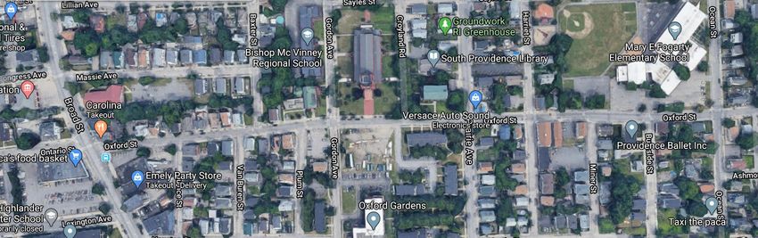
Why these streets?
• City considered factors such as connectivity,
  access, and equity to determine which streets
  should move forward in 2020-2021:
  – Connectivity: Does the street connect to an existing or funded
    Urban Trail segment?
  – Access: Does the street provide access to important
    destinations such as schools, jobs, parks, libraries, cultural
    institutions, local businesses
  – Equity: we must invest in our neighborhoods equitably to
    overcome past injustices; our government has harmed
    communities of color with past unhealthy transportation
    decisions
Neighborhood Greenways are not two-way
protected urban trails
Two-way protected urban trails are planned for major
arterial roads where there are higher speeds and volumes of
cars
Neighborhood Greenways are not off-road
shared use paths
Off-road shared use paths are planned along the
Woonasquatucket River or through parks and open spaces
What are neighborhood
greenways?
• Modest signage, striping, and traffic
  calming improvements on residential side
  streets
  – Speed lumps (on some streets)
  – Shared lane markings (sharrows) in direction of car
    traffic
  – When car traffic one-way, new contra-flow bike
    lanes
  – On-street parking generally preserved
  – Future wayfinding signage
Speed lumps
Speed lumps are the most effective traffic calming used by
the City and the slower car speeds make these streets safer
for people walking and bicycling
Signage
Signage identifies streets as safe streets for people walking,
running, biking
Shared Lane Markings (Sharrows)
Shared lane markings also help identify the street as a
Neighborhood Greenway and remind drivers that people
riding bicyles may be present
Contra-flow Bike Lanes
On streets that are one-way for cars, contra-flow bike lanes
allow people riding bicycles to travel in the opposite
direction
Wayfinding
signage
Examples of signage from
other cities; Providence’s
signage will be designed
with community input over
the next several months
Neighborhood Greenways are not off-road
shared use paths
Off-road shared use paths are planned along the
Woonasquatucket River or through parks and open spaces
Neighborhood Greenways
• Aleppo Street (Manton to Riverside Park)
• Delaine Street (Manton to Harris)
• Tuxedo and Amherst (Atwells to Valley)
• Sonoma Court (Delaine Street to Donigian Park)
• Oxford and Ontario streets (Allens to Elmwood)
• Sackett Street (Elmwood to Broad)
• Farragut and Vermont avenues (Roger Williams Park to
Michigan Ave)
• Peace and Waverly streets (Prairie to 6/10 Service Road)
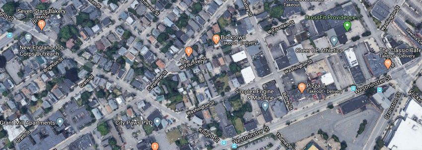
• Fricker and Lockwood streets (Atwells to Westminster)
• Knight, Washington, and Winter streets (Westminster to
Prairie)Neighborhood Greenways Planned for 2020-21
Neighborhood
     Greenways planned
     for 2020-21

     Existing Urban Trail
     segments

     Soon to be
     constructed
     segments

     Potential future
     segments

Neighborhood Greenways within Citywide
Urban Trail Network
Fricker & Lockwood
Contra-flow bike lane between Pine & BroadKnight, Washington, Winter
Knight, Washington, Winter
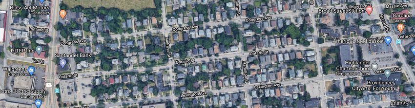
Contra-flow bike lane between Broadway and SwissOntario
Several existing speed lumps west of HamiltonOxford
Oxford
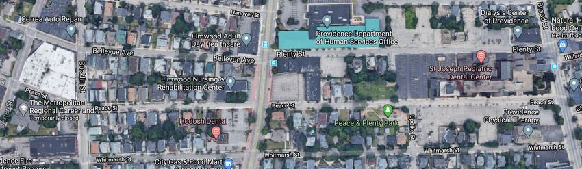
Peace
Contra-flow bike lane between Bucklin and Elmwood
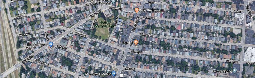
and between Updike and BroadWaverly
Sackett
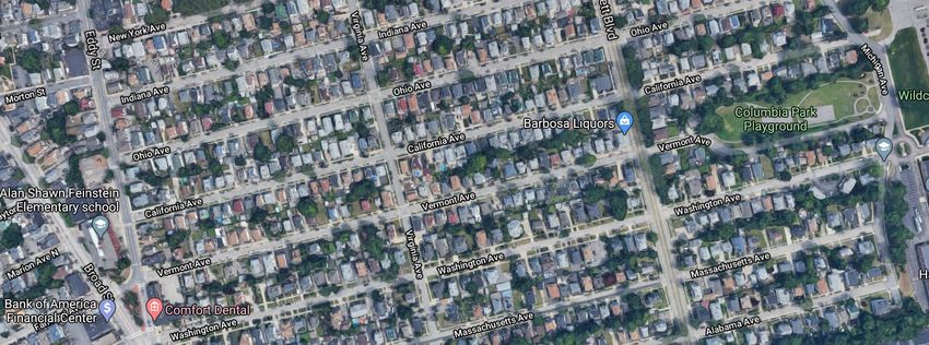
Several existing speed lumps throughout SackettVermont
Farragut

           Two existing speed lumps on Farragut
Aleppo
Delaine & Sonoma

         Only sharrows, no speed lumps, are planned on Sonoma Ct
Delaine
Tuxedo & Amherst

     Only sharrows, no speed lumps, are planned on Sonoma Ct
     Existing speed lumps on Valley Street
Virtual Meeting Procedure
• Type questions or comments in Q&A at any time
(press Q&A button at bottom of your screen)
• Staff will read and answer during the Question and
Answer time after presentation
• If you would prefer to speak during the Q&A
session, use the “raise hand” feature (*9 on phone)
– Staff will call on you during the Question and Answer
time at the end of the presentation
– State your first name, last name, and the street where you
live before saying anything elseFor more information • www.providenceri.gov/planning/great-streets/ – Read the Great Streets Master Plan – View this presentation again • Alex Ellis, Principal Planner – aellis@providenceri.gov
THANK YOU
  City of Providence
You can also read


