Monitoring Report Land Use Recovery Plan - Te Mahere Whakahaumanu Taone - Environment Canterbury
←
→
Page content transcription
If your browser does not render page correctly, please read the page content below
Land Use Recovery Plan
Te Mahere Whakahaumanu Taone

Monitoring
Report
For the year ended December 2014
Executive Summary

        The Land Use Recovery Plan (LURP) was developed to help achieve the vision of the
        Recovery Strategy for Greater Christchurch by providing direction for residential and
        business land use development to support recovery and rebuilding across metropolitan
        greater Christchurch over the next 10-15 years. Monitoring the implementation of the LURP
        is an important part of ensuring progress towards recovery from the earthquakes. This is
        the first Monitoring Report of the LURP, covering the period from December 2013 to
        December 2014.

        The delivery of the LURP is broken down into a series of 50 actions to be undertaken by
        central and local government agencies to ensure the recovery needs of residential and
        business land use are met. Of these 50 actions, the majority have been completed. The
        remaining actions are either ongoing or will be completed by the end of 2015.

        The actions providing statutory direction have resulted in changes to the Canterbury
        Regional Policy Statement, the operational Christchurch City Plan and the Waimakariri and
        Selwyn District Plans to facilitate recovery. A number of actions have also provided direction
        to, and prioritisation of, matters in the Christchurch Replacement District Plan process
        currently being undertaken. The remaining actions have been progressed by agencies in
        support of achieving the desired outcomes of the LURP.

        The LURP provides for new households and businesses in greenfield areas as well as
        opportunities for intensification and infill within existing areas. The greater Christchurch
        region has suffered a loss of a significant number of houses including some 7,100 houses
        within the residential red zone.

        Nearly three-quarters (28,500) of the potential 40,000 new residential sections in greenfield
        areas in greater Christchurch have been rezoned. Of these, around 13,000 sections are
        subject to, or have received subdivision consent. The greatest areas of new housing have
        been in Selwyn and Waimakariri districts.

        Since February 2011, building consents have been issued for 16,800 new residential
        houses in greater Christchurch. The majority of these replace existing housing stock.
        Housing affordability in greater Christchurch remains an issue despite the LURP’s enabling
        provisions for broader housing choice.

        The LURP identifies key activity centres and neighbourhood centres to meet the needs of
        businesses and communities. Defining the extent of key activity areas in Christchurch City
        will occur through the Christchurch Replacement District Plan. Christchurch City, Selwyn
        District and Waimakariri District Council have all identified measures to revitalise key activity
        centres. Of the almost 1,000 hectares of greenfield land identified to meet the future needs
        of business, around 60 per cent has already been zoned to allow for business activity. Since
        February 2011, 1.3 million square metres of business floor space has been consented for
        business in Christchurch of which around 360,000 square metres of new commercial and
        industrial floorspace has been consented in the central city.

2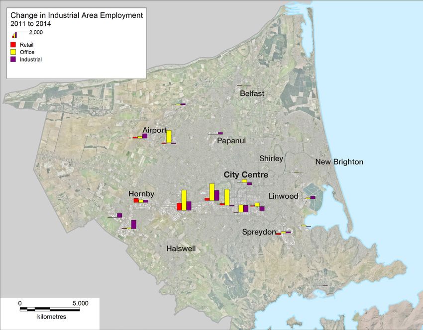
The dislocation that resulted from the Canterbury earthquakes significantly changed the
nature of transport demand in greater Christchurch. Travel patterns and demand changed
as many businesses and households relocated. Travelling via motor vehicle remains the
primary means of travel to work. Public transport patronage continues to be down on pre-
earthquake levels, due in part to the dislocation and dispersal of business activity. However,
changes to bus services introduced in 2012, have resulted in positive growth across the
network as the recovery progresses.

                                                                                             3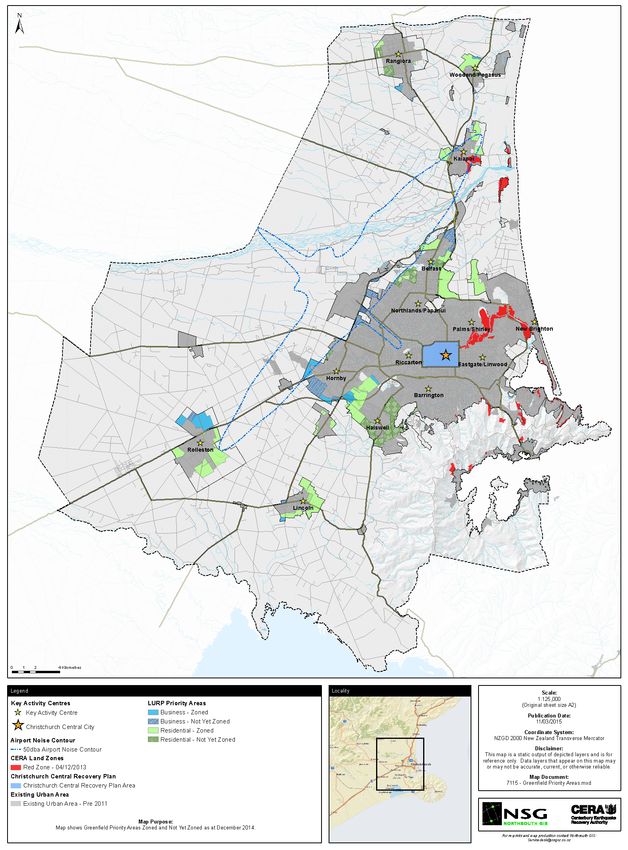
Contents

       INTRODUCTION................................................................................................................5
          Structure of the Land Use Recovery Plan........................................................................5
          Land Use Recovery Plan outcomes.................................................................................5
          Monitoring the Land Use Recovery Plan..........................................................................6
          Review of the Land Use Recovery Plan...........................................................................7

       PROGRESS TOWARDS ACHIEVING OUTCOMES..........................................................8
         Direction and coordination...............................................................................................8
         Communities and housing.............................................................................................10
         Business.......................................................................................................................12
         Transport.......................................................................................................................13

       PROGRESS TOWARDS ACHIEVING ACTIONS.............................................................18
         Rebuilding communities................................................................................................19
         Building new communities.............................................................................................24
         Providing for business...................................................................................................26
         Delivering infrastructure services...................................................................................30
         Natural hazards and environmental constraints.............................................................33
         Implementing delivery mechanisms for recovery............................................................33

       MONITORING INDICATORS...........................................................................................36
         Indicator 1: Availability of residential greenfield priority area land....................................36
         Indicator 2: Residential building consents......................................................................38
         Indicator 3: Residential intensification............................................................................41
         Indicator 4: Business building consents.........................................................................43
         Indicator 5: Business activity.........................................................................................45

4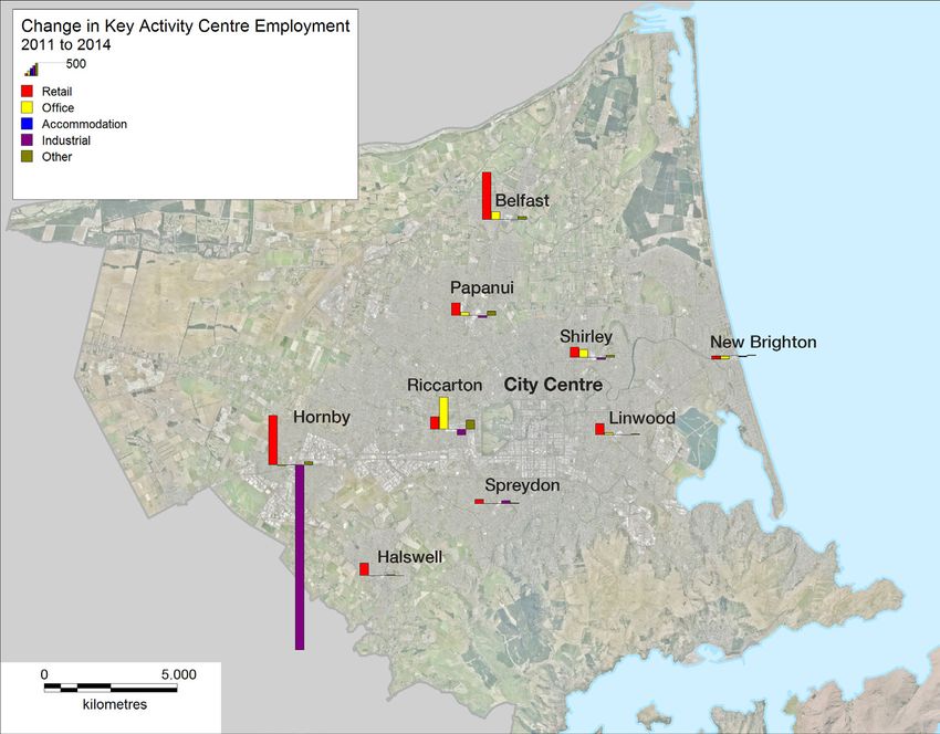
Introduction

         This report provides a summary of the progress made against actions and outcomes in the Land
         Use Recovery Plan (LURP). It is the first Monitoring Report for the LURP since it came into effect on
         6 December 2013.

         The LURP is a statutory document developed to provide direction for residential and business land
         use development to support recovery and rebuilding across metropolitan greater Christchurch1 over
         the next 10-15 years. It directs Christchurch City Council, Waimakariri and Selwyn District Councils
         and the Canterbury Regional Council (Environment Canterbury) to make changes to District Plans, the
         Canterbury Regional Policy Statement and other instruments. Some of these changes took immediate
         effect, while others have been progressed by the relevant council within specified timeframes.

         Structure of the Land Use Recovery Plan
         Section 3.3 of the LURP sets out 15 outcomes for responding to issues described in the Recovery
         Plan. The outcomes fall under the topic areas of:

         •   direction and coordination
         •   communities and housing
         •   business
         •   transport.

         To achieve the outcomes, the LURP identifies 50 inter-related critical actions required in the short
         and medium term to coordinate and advance decision making about land use, as well as who is
         responsible for these actions and when they must be completed.

         The actions include statutory directions, which use powers under the Canterbury Earthquake
         Recovery Act 2011 (CER Act) to direct changes to the Resource Management Act 1991 and other
         statutory documents, as well as initiatives the strategic partners have agreed to undertake to help
         achieve the desired outcomes.

         Land Use Recovery Plan outcomes
         Section 3.3 of the LURP outlines the following 15 outcomes:

         Direction and coordination

         1.	A clear planning framework directs where and how new development should occur so that it
             integrates efficiently and effectively with infrastructure programmes and avoids key hazards
             and constraints.
         2.	Servicing of land for housing and business and its release to the market keep pace with
             anticipated demand.
         3.	Land use recovery integrates with and supports wider recovery activity, particularly within the
             central city.
         4.	RMA plans and regulatory processes enable rebuilding and development to go ahead without
             unnecessary impediments.
         5.	A supportive and certain regulatory environment provides investor confidence to obtain the best
             outcomes from resources used in the recovery.

         1 Metropolitan greater Christchurch, as referenced in the LURP, is a smaller area of greater Christchurch comprising the city and
         the towns and rural areas between Rangiora, Rolleston and Lincoln.

                                                                                                                                             5
Communities and housing

    6.	The range, quality and price of new housing meets the diverse and changing needs of those
        seeking to buy or rent, including the needs of a growing temporary rebuild workforce.
    7.	Opportunities are available for the market to deliver comprehensive redevelopment in suitable
        existing neighbourhoods.
    8.	Investment in community facilities and services supports vibrant key activity centres and
        neighbourhood centres.

    Business

    9.	Businesses in damaged areas are able to rebuild cost effectively and to improve their use of land,
        buildings, plant and machinery.
    10.	Key activity centres and neighbourhood centres provide for commercial activity needs and support
        rejuvenation of damaged areas.
    11.	Sufficient industrial business land is available to accommodate relocations and industrial
        sector growth.

    Transport

    12.	Congestion arising from road works and from changes in travel due to development, including
        business and household relocations, is minimised.
    13.	An attractive and financially viable public transport network supports significantly increased use.
    14. More people walk and cycle in and between centres of activity and for local trips.
    15.	An efficient freight network provides for the needs of freight transport, particularly in relation to
        access to the port and the airport.

    Monitoring the Land Use Recovery Plan
    The LURP provides for the preparation of an annual Monitoring Report summarising progress on the
    implementation and achievement of the outcomes. An update on the implementation of actions is
    reported quarterly through the Recovery Strategy Governance framework.

    In March 2014, a draft Monitoring Plan was prepared to provide an operational framework for
    monitoring the achievement of the LURP’s outcomes. A series of indicators was identified in the
    draft Monitoring Plan to help monitor the LURP’s 15 outcomes. These indicators have informed the
    collection of data in this report. New indicators and data sources will be reported on if considered
    necessary.

    The timeframes for achieving the actions in the LURP vary. As a result, not all actions have been
    completed with some progressing over longer timeframes than this Monitoring Report covers.2

    It has also been found that there are differences in the ability to effectively monitor outcomes and
    actions in the LURP. Actions such as the rezoning of greenfield land for new housing or business uses,
    can be more easily monitored and results reported on. In contrast, others have a more enabling effect
    and activity and are more challenging to directly report on. Where this is the case, indicators have
    been used to provide a quantitative assessment of rebuild and general demographic trends.

    2 The timeframes for implementing actions, set out in the LURP are varied they may be 3, 6, 9 or 12 months from the date of
    gazettal or ongoing.

6
Over time it is anticipated that monitoring requirements for the LURP will become integrated within the
statutory plans and processes of the strategic partners.

This Monitoring Report informs, and is informed by, the monitoring of the Recovery Strategy for
Greater Christchurch.

Review of the Land Use Recovery Plan
The information in this Monitoring Report is intended to inform a formal review of the LURP to be
undertaken by Environment Canterbury, in collaboration with the strategic partners, in 2015. The
review will cover all aspects of the LURP, including whether it is necessary to amend or add to the
LURP to enable recovery. Further information on the review can be viewed at:
www.ecan.govt.nz/LURP

                                                                                                      7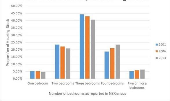
Progress towards achieving outcomes

        The LURP requires the 15 outcomes to be monitored to measure the success of its implementation.
        This section provides an update on progress for the period from December 2013 (when the LURP
        came into effect) to December 2014, unless otherwise stated.

        Direction and coordination
        Outcome 1: A clear planning framework directs where and how new development
        should occur so that it integrates efficiently and effectively with infrastructure
        programmes and avoids key hazards and constraints.

        As directed by the LURP, a new chapter was included in the Canterbury Regional Policy Statement
        (RPS) to provide a coordinated land use framework to enable and support earthquake recovery,
        rebuilding and redevelopment.3 Chapter 6 – Recovery and Rebuilding of Greater Christchurch came
        into effect on 6 December 2013, the day the LURP was notified in the Gazette.

        Chapter 6 of the RPS includes provisions on:

        •	the location, type and mix of residential and business activities to be provided for in metropolitan
           greater Christchurch, including greenfield priority areas for development through to 2028
        •	the network or key activity centres needed to provide a focus for commercial activity,
           medium density housing, community facilities, public green space, and public and active
           transport networks
        •	areas where rebuilding and redevelopment may not occur within the period of the LURP, including
           those areas constrained by natural hazards and environmental constraints.

        District Plans in greater Christchurch, including the Christchurch Replacement District Plan, must give
        effect to Chapter 6. This has created a new framework for land use planning and decision making in
        greater Christchurch.

        Amendments have also been made to the operative Christchurch City Plan, the Waimakariri and
        Selwyn District Plans and to Environment Canterbury Regional Plans to provide further clarity and
        planning certainty within this decision making framework. Further information on these amendments is
        provided in the ‘Progress towards achieving Actions’ section of this report.

        Outcome 2: Servicing of land for housing and business and its release to the
        market keep pace with anticipated demand.

        The LURP identified greenfield priority areas for residential and business uses. Some of these areas
        were rezoned for such activities prior to December 2013. The remaining areas have been, or will
        be, rezoned through amendments to the Christchurch City Plan, and the Selwyn and Waimakariri
        District Plans.4

        The greater Christchurch region has suffered a loss of some 7,100 houses within the residential red
        zone. As at 31 December 2014, there was a total of 168,410 residential properties with insurance
        claims for damage to houses. Of those, around 23,000 are being resolved by private insurers by way of
        external resolution (such as cash settlement or house reinstatement), a repair or a rebuild. The Insurance
        Council New Zealand (ICNZ) is confident the majority of over-cap claims will be settled by the end of
        2016, with the remainder made up of more complex repairs or rebuilds, such as multi-unit houses.5

        3 Action 44 relates.
        4 Actions 15 –19 and 24–27 relate.
        5 Insurance Council of New Zealand, www.icnz.org.nz/private-insurers-pay-out-14-billion-settling-canterbury-earthquake-claims,
        16 February 2015.

8
Of the greenfield priority areas identified for residential purposes, rezoning for residential use has
provided for an anticipated 28,500 sections. This is nearly three-quarters of the potential sections for
households in greater Christchurch identified in the LURP (see Indicator 1: Availability of residential
greenfield priority area land).

Around 60 per cent of the almost 1,000 hectares of greenfield priority area land identified for business
activity has been re-zoned.

Since February 2011, building consents have been issued for 16,800 new residential houses in
the greater Christchurch area. Over half of these were in Christchurch with the remaining 44 per cent
evenly distributed between Waimakariri and Selwyn districts. Of the housing that has been consented
in Christchurch, 62 per cent (just over 5,000 additional houses) have resulted in additional housing
stock. The number of additional houses is not higher because many of the consents have been for
replacement housing.

In Selwyn and Waimakariri, the rate of new housing has doubled since February 2011. Waimakariri has
experienced an increase of 220 per cent and Selwyn an increase of 193 per cent in new residential
units since the earthquakes compared with the 10 years preceding. The rate of development in
Waimakariri has been slowing down since the beginning of 2014 although it is still higher than before
the earthquakes.

Christchurch City Council, and Selwyn and Waimakariri District Councils have also made, or are in
the process of making, amendments to their planning documents to better enable and encourage
redevelopment or intensification within existing urban areas.6 These amendments will create an
additional opportunity for the market to boost the supply of housing and mixed-use developments.
The rate of infill housing in Christchurch is lower than pre-earthquake levels but is steadily increasing
(see Indicator 3: Residential Intensification)

Christchurch City Council and Selwyn and Waimakariri District Councils have also aligned
infrastructure planning and funding in their Long Term Plans and the Regional Land Transport Plan to
address the anticipated release of land by private developers through subdivision.7

Outcome 3: Land use recovery integrates with and supports wider recovery
activity, particularly within the central city.

The planning framework created through Chapter 6 of the RPS encompasses the central city area
and is consistent with the Christchurch Central Recovery Plan and with amendments made by the
Recovery Plan to the operative Christchurch City Plan. Chapter 6 reinforces the role of the central
city as the primary commercial centre and includes transport policies to link the central city with key
activity centres in the suburbs and district townships.

Significant recovery activity has also been progressed within the central city which is outside the
scope of the LURP. Addendums made to the Christchurch Central Recovery Plan, including the
chapters An Accessible City and A Liveable City, advance integration with the wider city.

6 Actions 1, 2 , 4, 6, 7–10.
7 Actions 11–14 and 32–35 relate.

                                                                                                            9
Outcome 4: RMA plans and regulatory processes enable rebuilding and
development to go ahead without unnecessary impediments.
Environment Canterbury, Christchurch City Council and Waimakariri and Selwyn District Councils
have reviewed their respective Regional and District Plans to provide for an enabling and supportive
regulatory environment for recovery and rebuilding. These reviews have resulted in, or are in the
process of making, changes to zoning and also removed unnecessary impediments to development
(see ‘Progress towards achieving Actions’).
An analysis of recent consenting activity suggests that the majority of consents are being processed
within statutory timeframes.8
Outcome 5: A supportive and certain regulatory environment provides investor
confidence to obtain the best outcomes from resources used in the recovery.
As in outcomes 1 and 4, amendments to the regulatory environment have sought to provide greater
certainty and a more enabling and supportive approach to investment decisions.
Analysis by the New Zealand Institute of Economic Research (NZIER)9 and others suggests investor
confidence in the Canterbury region continues to be high generally but there is little information
specific to such business opinion in relation to the regulatory environment.
Independent indicators such as the Commercial Property Investor Confidence Survey can provide
some measure of investor confidence. In the December 2014 quarter, commercial property investor
confidence remained high with investor confidence at a net positive of 48 per cent. This is the
most confident that respondents have been in the future performance of the Christchurch property
market since September 2013.10 However, positive sentiment across the small business segment in
Canterbury dropped in the December 2014 quarter.11
Communities and housing
Outcome 6: The range, quality and price of new housing meets the diverse and
changing needs of those seeking to buy or rent, including the needs of a growing
temporary rebuild workforce.
Broadening housing choice through a focus on enabling and encouraging smaller, more affordable
housing in existing areas is currently a market segment that is underprovided for. Figure 1 shows the
predominance of houses in greater Christchurch with three or more bedrooms and the percentage of
more modestly sized houses reducing.
Actions in the LURP supporting intensification have been difficult to implement and monitor (see
Indicator 3: Residential Intensification). The ramp up of the rebuild has generally taken longer than
envisaged. As a result, the realisation of opportunities for redevelopment has also been delayed.
Monitoring of the greater Christchurch housing market undertaken by the Ministry of Business,
Innovation and Employment (using quotable value, consents and other data) supports the general
8 In February 2015, Christchurch City Council processed 98 per cent of its land use resource consent applications, 100 per cent of
its subdivision resource consent applications and 98 per cent of its building consent applications within statutory timeframes. For
the year to date (1 July 2014 – 1 January 2015), the Selwyn District Council processed 91.25 per cent of its building consents and
99 per cent of its resource consent applications within statutory timeframes.
9 NZIER Quarterly Survey of Business Opinion (QSBO), January 2015.
10 Colliers International Research, Commercial Property Investor Confidence Survey Q4 2014.
11 ANZ Business Micro Scope: Still feeling good 8 January 2015, www.anz.co.nz
10view that average house prices are rising. Since 2010, average rents in greater Christchurch have risen
by 39 per cent and house values by 28 per cent. However, recent signs are that the rapid growth in the
housing market is slowing.12
Christchurch house values, as at August 2014 to October 2014, were just below the national average
of $484,307. While the total number of rental properties increased during 2014, helping to ease rental
prices, overall the rent profile of greater Christchurch increased by some 5.7 per cent over the year to
October 2014. Overall, housing affordability in Canterbury has worsened. This is consistent with trends
nationally, mainly due to an increase in the national median house price as well as increases in average
mortgage interest rates.13
Figure 1: Greater Christchurch dwelling size trends – number of bedrooms, 2001, 2006 and 2013
Data sourced from Canterbury Development Corporation using Statistics New Zealand data
Outcome 7: Opportunities are available for the market to deliver comprehensive
redevelopment in suitable existing neighbourhoods.
Actions in the LURP made amendments to further enable and streamline opportunities for
comprehensive development. The inclusion of the Enhanced Development Mechanism14 and
Community Redevelopment Mechanisms15 provisions in the operative Christchurch City Plan have
created a more enabling planning regime for 126 and 379 hectares of land respectively (see Progress
12 Ministry of Business, Innovation and Employment, New Zealand Housing and Construction Quarterly, December 2014,
www.dbh.govt.nz/nz-housing-and-construction-quarterly.
13 Massey University, December 2014; Home Affordability Report, Quarterly Survey December 2014, Volume 24, Number 4; Massey
University.
14 The Enhanced Development Mechanism is a set of City Plan provisions that enable medium density housing developments
such as town houses or terrace houses, on qualifying sites within certain zones in the Christchurch City Plan. It encourages the
amalgamation of sites, allowing for more efficient use of land and the achievement of a better level of amenity within the site and
neighbourhood.
15 The Community Housing Redevelopment Mechanism applies to specific areas of Christchurch that contain clusters of social
or community housing. It allows for medium density redevelopment to provide for better use of land and a wider range of housing
types to suit different kinds of households (eg, town houses and terrace houses). Developments using this mechanism will be able
to contain a mix of community housing and privately owned houses. The Community Housing Redevelopment Mechanism is only in
place until 31 December 2018.
11towards achieving Actions: Action 1).16 However, the rate of intensification is low (see Indicator 3:
Residential Intensification).
Outcome 8: Investment in community facilities and services supports vibrant key
activity centres and neighbourhood centres.
Christchurch City Council, and Selwyn and Waimakariri District Councils have progressed a range
of changes to their respective Local Government Act 2002 instruments to ensure that their planning
and funding programmes align to support investment in key activity and neighbourhood centres. This
includes recognition and alignment in their Long-Term Plans that they are preparing.17 Significant
investment has also been made through the councils’ repair and enhancement programmes.
Business
Outcome 9: Businesses in damaged areas are able to rebuild cost effectively and
to improve their use of land, buildings, plant and machinery.
Outside the central city, the earthquakes damaged business premises and industrial land, especially
in the east of Christchurch. Business was interrupted and relocated (temporary, permanent and
ongoing) and some businesses failed. The movement of goods and of people travelling to and from
work also changed.
Total consents issued across greater Christchurch for business activities increased between 2011 and
2012. In Christchurch and Waimakariri, consents have tapered off while in Selwyn they dropped away
in 2013 but have increased again in 2015. The majority of business consents in Selwyn have been for
development within the industrial zone in Rolleston (see Indicator 4: Business building consents).
Selwyn and Waimakariri District Councils have changed their plans to rebuild existing business areas.
This included Waimakariri District Council amending its plan to provide for the effects of vibration and
noise arising from new construction.
Christchurch City Council and Selwyn District Council have also undertaken to support the rebuilding
of commercial businesses. Christchurch City Council identified that there has been little uptake of
these services. Christchurch City Council, Selwyn District Council and Waimakariri District Council
now offer support for larger consenting projects if requested.
Outcome 10: Key activity centres and neighbourhood centres provide for
commercial activity needs and support rejuvenation of damaged areas.
Prior to the earthquakes, Selwyn and Waimakariri District Councils had undertaken town centre
strategies and supporting research on commercial needs to be accommodated in the key satellite
towns, such as Rolleston, Lincoln, Rangiora and Kaiapoi. Actions in the LURP have seen, or will see,
the necessary planning provisions to enact the town centre strategies incorporated into the Selwyn
and Waimakariri District Plans.
Christchurch City Council has developed comprehensive masterplans for New Brighton, Edgeware,
Linwood, Sydenham, Selwyn Street, Lyttelton, Ferry Road, Main Road and Sumner. The Christchurch
Replacement District Plan will define the extent and revitalisation of key activity centres and the
rebuilding of existing business areas (see Indicator 4: Business building consents and Indicator 5:
Business activity).
16 Action 1 relates.
17 Actions 11 – 14 relate.
12Office and retail needs in greater Christchurch will be significantly influenced by the vision and
successful implementation of the Christchurch Central Recovery Plan. The Christchurch Central
Recovery Plan offers a rejuvenated environment, new commercial floorspace and a clustering
of businesses.
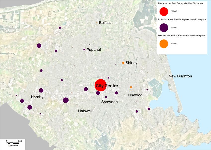
Overall the key activity centres outside the central city experienced growth in new business floor
space. The central city growth in business floor space has continued to increase.
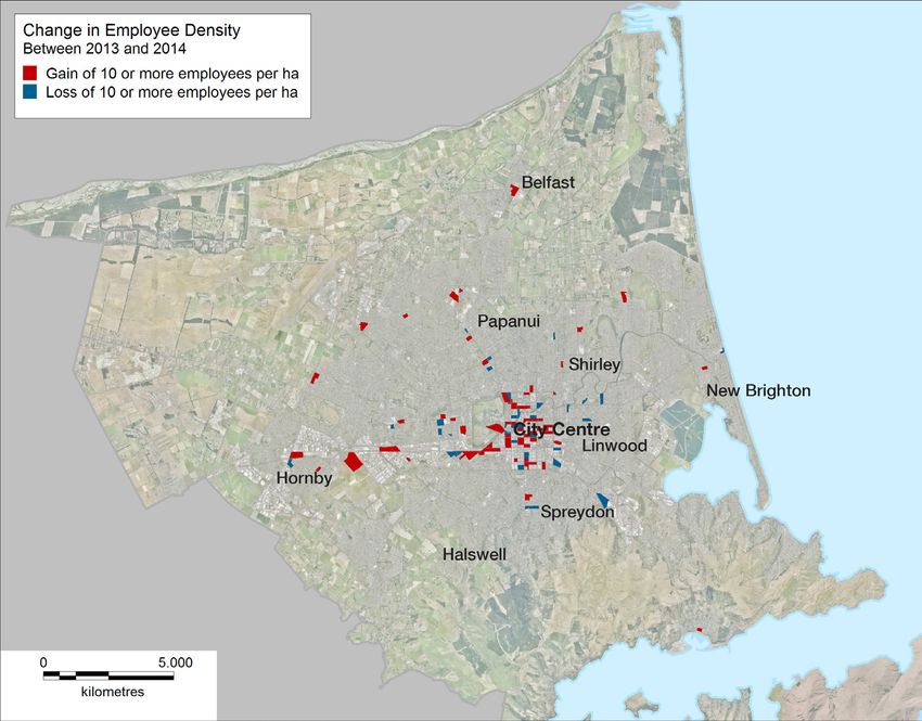
The range of businesses and employment in the key activity centres in Christchurch has seen
considerable change between 2010 and 2014. Industrial areas close to the central city gained office
employees and Hornby experienced growth in retail activity at the expense of industrial activity (see
Indicator 5: Business).
Outcome 11: Sufficient industrial business land is available to accommodate
relocations and industrial sector growth.
The LURP seeks to ensure there is sufficient and suitable industrial land for the recovery through to
2028. Greenfield priority areas together with vacant industrial land in existing zones are described
as being “sufficient to meet future demand, as well as allowing for choice of location and market
competition”. The land will provide for:
• ongoing industrial business relocations
• anticipated industrial growth (including the growth of sectors involved in recovery
• a range of industrial activities spread over a wider geographical area.
Of the almost 1,000 hectares of new business land that was identified in the LURP, around
60 per cent has been zoned to allow for business activity (see Figure 5). The majority of this land
is in Christchurch while 200 hectares are in Selwyn (primarily in Rolleston and a small amount
in Lincoln). There are small areas in Waimakariri, totalling around 60 hectares.
In Christchurch at the end of June 2014, there was 740 hectares of vacant industrial land as well as
another 380 hectares that is still to be zoned. The pre-earthquake rate of industrial land take-up was
around 25 hectares per annum. At this rate there is currently around 30 years of zoned industrial land
in the city with an additional 15 years to be zoned.
Transport
Outcome 12: Congestion arising from road works and from changes in travel due
to development, including business and household relocations, is minimised.
The earthquakes significantly changed the nature of transport demand in greater Christchurch. Many
businesses and households relocated, leading to changes in travel patterns, significant travel delays,
and a large reduction in patronage in public transport services. With public access to most of the
central city limited for safety reasons, businesses relocated to other parts of greater Christchurch
or closed, removing 20,000 jobs from the central city. Census data for 2006 and 2013 show the
population of Christchurch decreased by 2 per cent to 341,500, Selwyn increased by nearly a third to
44,595, and Waimakariri increased by 17 per cent to 49,989. As a result, commuters to Christchurch
increased from 17,500 in 2006 to 23,000.
13Land use is still changing as damaged houses are repaired, new houses are built and businesses
continue to relocate. Major projects, such as the Roads of National Significance programme, have
accommodated some of this demand, but issues remain, particularly in the northern corridor.
The situation remains dynamic and further changes are expected as housing, business areas and
infrastructure are repaired or rebuilt.
Congestion, measured using a congestion index based on travel time (km), has been increasing since
2009. It was exacerbated in 2011 because of road works and new travel patterns as businesses
shifted from the central city and new developments occurred (see Figure 2). As the rebuild continues,
the number of road works will reduce and new travel patterns will stabilise.
Figure 2 - Comparison of Christchurch congestion indicators 2006-2014
Note: Annual data as at March, with the exception of 2011 (as at April).
Data sourced from the New Zealand Transport Agency
Transport demand is driven by population trends, economic growth and vehicle availability. Traffic
growth is a problem in greater Christchurch because of the density of traffic, the continuing dispersal
of population and businesses, and growth in households and employment. Increasing traffic volumes
around Christchurch are leading to longer and less reliable travel times, with the traffic congestion
index increasing 40 per cent between 2009 and 2013.
Outcome 13: An attractive and financially viable public transport network supports
significantly increased use.
Since September 2010, the earthquakes has had a major impact on public transport patronage in
greater Christchurch (Figure 3), due mainly to the closure of a large number of travel destinations in
the central city. Total patronage for the year to December 2011 was 10.1 million, down 40 per cent on
pre-earthquake levels.
14In response to the changes in travel demand following the earthquakes, a new network approach
has been adopted. Significant changes were introduced to bus services in northern and southern
Christchurch and Waimakariri district in December 2012 which led to positive growth across the
network. Patronage grew by 18.7 per cent in 2012/13 and by 5.8 per cent in 2013/14.
It is anticipated that the final stage of route changes made in December 2014, supported by new
infrastructure such as the Riccarton bus lounge and the central city Bus Interchange, will further
stimulate patronage growth.
Figure 3 - Annual bus patronage for greater Christchurch 1992/1993-2013/14
Patronage
Year to June
Data sourced from Environment Canterbury
Outcome 14: More people walk and cycle in and between centres of activity and
for local trips.
Most cycle commuting or shopping trips are currently made on the road network. In Christchurch,
$156 million will be invested in 13 major cycle routes over the next nine years; this will be confirmed
through the draft Long Term Plan consultation. Council has prioritised four of the 13 cycleways for
completion by 2019.
Travelling via motor vehicle (private, company or passenger) remains the primary means of travel to
work across greater Christchurch (see Figure 4). The proportion of people reporting motor vehicle
as their main means of travel to work has increased across Christchurch, Selwyn and Waimakariri
between 2001 and 2013. The proportion of people reporting cycling, walking or jogging as their
primary means of travel to work has decreased in Waimakariri (from 5 per cent in 2001 to
4 per cent in 2013) and Selwyn (from 8 per cent in 2006 to 6 per cent in 2013) districts, while it
has remained static at 10 per cent in Christchurch.18
18 New Zealand Transport Agency data.
15Increasing the use of modes other than the motor vehicle and optimising the use of the existing
network are primary strategies for the future set out in the Greater Christchurch Transport Statement.
Enhancing transport choice through greater investment in cycling and public transport infrastructure is
a priority to address future travel demand.
Figure 4: Main means of travel to work in greater Christchurch, 2001, 2006 and 2013
Data sourced from Statistics New Zealand, census of population and dwellings
Outcome 15: An efficient freight network provides for the needs of freight
transport, particularly in relation to access to the port and the airport.
Heightened construction activity associated with earthquake recovery has increased freight demand
within greater Christchurch. For example, in the context of heavy commercial vehicles through
Lyttelton tunnel, forecast volumes (without the rebuild) have been reached 10 years in advance (2030
forecast volumes are set to be reached as soon as 2020) due to the import of build related materials
over the short term.19 This increased freight demand is expected to continue for up to 10 years and is
anticipated to have a significant impact on the importation and transport of construction materials into
and within the greater Christchurch area.20
The key challenges for freight on the transport network overall include:
• the transportation of 4 million tonnes of aggregate and 480,000 tonnes of asphalt, concrete and
steel during the rebuild, with high volumes expected to continue for many years
• increased agricultural production leading to more and heavier truck movements
19 Aurecon for the Greater Christchurch Transport Statement partners, Greater Christchurch Freight Infrastructure Statement,
July 2014.
20 Aurecon for the Greater Christchurch Transport Statement partners, Greater Christchurch Freight Demand Statement,
July 2014.
16• increasing travel times and less reliable travel time on key freight routes around greater
Christchurch, particularly access to Lyttelton from the west and south via Brougham Street21
• sub-standard and, at times, unsafe access to and from areas of high freight demand such as
major manufacturing or processing facilities, industrial areas, warehousing and distribution centres
• providing further efficiency improvements, such as upgrading the High Productivity Motor Vehicles
(HPMV) network or providing better connections between road and rail.
A priority for transport in greater Christchurch is to improve the network to increase efficiency on key
freight routes. This includes completing the Roads of National Significance, improving the Brougham
Street corridor to the Port of Lyttelton22, strengthening structures for HPMV and addressing access to
freight hubs.
The Urban Development Strategy partners have completed a Greater Christchurch Freight Study.
The study is in response to a number of actions in the Greater Canterbury Transport Strategy actions
and to LURP Action 40. It is being led by the New Zealand Transport Agency in collaboration with
Christchurch City Council, Waimakariri District Council, Selwyn District Council and Environment
Canterbury, and is supported by Lyttelton Port of Christchurch, KiwiRail and Christchurch International
Airport Limited. Further work will be undertaken on the implementation of the study’s findings.
In June 2014, Environment Canterbury was directed to prepare a draft Lyttelton Port Recovery Plan to
address a wide range of matters including the recovery and enhancement of the damaged port and
the implications of this work for transport, supporting infrastructure and connectivity to the Lyttelton
town centre and the wellbeing of surrounding communities. It is anticipated this Recovery Plan will
be gazetted in December 2015. The Lyttelton Port Company is also developing an intermodal freight
facility at Rolleston.
21 Source: http://ecan.govt.nz/publications/Plans/Draft-RLTP-2015.pdf
22 Source: http://ecan.govt.nz/publications/Plans/Draft-RLTP-2015.pdf
17Progress towards achieving actions The following table reports on the status of the actions in the LURP. The LURP identified 50 actions for local and central government to meet recovery needs relating to residential and business land use. The actions are divided into statutory and non-statutory actions. Statutory actions use the Canterbury Earthquake Recovery Act 2011 (CER Act) powers to direct changes to Resource Management Act 1991 documents and other statutory instruments. The non-statutory actions are initiatives that local and central government have agreed to undertake to support the statutory changes and achieve the LURP’s 15 outcomes. Key: Green - completed Purple - ongoing Orange - to be completed 18
Action   LURP Action                                                 Action status                                                                                               Outcomes
     number

     Rebuilding communities
     Provide for housing needs in existing urban areas
     1.       Christchurch City Council is directed, pursuant to          The amendments set out in Appendix 2 (Amendment 1) of the LURP were made to the Christchurch                1, 2, 3, 4,
              section 24(1)(a) and (b) of the CER Act, to include         City Plan on gazettal of the LURP.                                                                          5, 6, 7, 11
              and remove objectives, policies and methods in the          As a result of these amendments:
              Christchurch City Plan in accordance with Appendix 2
                                                                          •	encumbrances have been discharged from 57 elderly persons houses and five family flats, enabling
              (Amendment 1).
                                                                             their conversion into residential units. These residential units are now able to be occupied by people
                                                                             younger than 65 years and non-family members.
                                                                          •	one resource consent has been granted for a 12 unit development using the Enhanced
                                                                             Development Mechanism provisions. Two other applications are currently being processed.
                                                                          •	164 houses have been consented using the Community Housing Redevelopment Mechanism
                                                                             provisions.
                                                                          •	resource consents have been granted to build two units on 13 vacant sites where previously
                                                                             there was only a single dwelling on each site. It is likely that other sites have been developed as a
                                                                             permitted activity under this intensification measure. Christchurch City Council does not currently
                                                                             monitor permitted activities so there is no data on how many of these sites have been developed.
     2.       Christchurch City Council to enable in the next             This action is being progressed through the Christchurch Replacement District Plan process.                 1, 2, 3, 4,
              review of its district plans to provide for the following   Information on the Replacement Plan process and updates can be found at:                                    5, 6, 7, 8,
              measures:                                                   www.chchplan.ihp.govt.nz                                                                                    11, 14
              Housing choice
              i. a range of housing types and locations recognising
                  the changing population and loss of housing options
                  as a result of the Canterbury earthquakes
              Intensification
              ii.	a choice of housing through a range of residential
                    density and development provisions to facilitate
                    intensified development
              iii.	comprehensive residential and mixed use
                    developments, including on brownfield sites
              Supporting rebuilding activities
              iv. reduced consenting and notification requirements
              v.	address the efficiency and effectiveness of urban
                  design provisions.

19
20
Action LURP Action Action status Outcomes
number
3. Waimakariri District Council is directed, pursuant to Amendments were made to the Waimakariri District Plan on gazettal of the LURP that identified on the 1, 2, 3, 4,
section 24(1)(a) and (b) of the CER Act, to amend its planning maps, the areas in the Waimakariri district that were greenfield priority areas for residential 5, 6, 7, 11,
district plan as set out in appendix 3 (Amendments 3, development and the proposed extent of infrastructure (sewerage, water supply and stormwater) 14
4 and 5). around urban areas in Waimakariri.
4. Waimakariri District Council is directed, pursuant to The Waimakariri District Council adopted changes to its District Plan on 3 February 2015. These 1, 2, 3, 4,
section 24(1)(c) of the CER Act, to change or vary the changes became operative on 23 February 2015. 5, 6, 7, 11,
objectives, policies and methods of its district plan 14
to the extent necessary to identify appropriate sites,
including brownfield sites, within the existing urban area
for intensified residential and mixed-use development
and enable comprehensive development of these sites.
5. Selwyn District Council is directed, pursuant to section Minor changes were made to provisions of the Selwyn District Plan on gazettal of the LURP to 1, 2, 3, 4,
24(1)(a) and (b) of the CER Act, to amend its district allow for more medium density development in Lincoln and the removal of a school from an Outline 5, 6, 7, 11,
plan as set out in appendix 4 (Amendment 2). Development Plan. 14
6. Selwyn District Council is directed, pursuant to Selwyn District Council resolved at its meeting on 10 December 2014 to make changes to its District 1, 2, 3, 4,
section 24(1)(c) of the CER Act, to change or vary the Plan. These changes were made operative on 13 December 2014. 5, 6, 7, 11,
objectives, policies and methods of its district plan 14
to the extent necessary to identify appropriate sites,
including brownfield sites, within the existing urban area
for intensified residential and mixed-use development
and enable comprehensive development of these sites.
7. To support Actions 1 and 2, Christchurch City Council A report and package of potential instruments were prepared within six months of the gazettal of the 1, 2, 3, 5,
is to develop a package of instruments to promote LURP. 6, 7, 11
intensification and city living, including affordable and In relation to development contributions, Christchurch City Council has considered:
temporary housing. This may include financial tools,
• extending the Central City Residential Rebate Scheme until 30 June 2016. The scheme provides
regulatory incentives, development contribution policies
for a full rebate of development contributions for additional residential units in the central city area
and other initiatives.
subject to criteria, to incentivise residential development within the central city area.
• waiving development contributions where existing family flats are being converted to second
residential units on a site. This is in place until 1 July 2015 when the 2015 Development
Contributions Policy comes into effect. At that time the Minor Residential Unit adjustment will apply.
Key features of the draft Development Contributions Policy include:
• a catchment approach for calculating development contributions to better target development
contributions in the areas where the Council needs to invest to cater for growth.
• wider application of the Minor Residential Unit adjustment.
• extending the period when a development contribution is reassessed from one to two years. This
means developers can rely on an assessment for two years providing greater certainty in terms of
development cost.Action LURP Action Action status Outcomes
number
Promote affordable housing
8. Christchurch City Council to enable a range of Christchurch City Council has progressed the following work to enable a range of exemplar, medium 1, 2, 3, 5,
exemplar medium density housing projects, including density housing projects: 6, 7, 11
design and testing of projects at: • The Spreydon Lodge (Dannemora) ‘Meadowlands’ subdivision was approved in principle as
• Bryndwr and Shirley by Housing New Zealand an exemplar by the Christchurch City Council on 24 April 2014. Joint evidence from Christchurch
Corporation City Council, the Canterbury Earthquake Recovery Authority and Dannemora was submitted to
• two locations (to be confirmed) by Christchurch City the Independent Hearings Panel on 23 December 2014. A final decision has been released. The
Council applicant will now follow a restricted discretionary resource consent process for the proposed
• Riccarton Racecourse by Christchurch Racecourse exemplar. An application for the first stage including 120 homes is expected in early 2015.
Reserve Trustees • Two Housing New Zealand Corporation sites in Bryndwr and Shirley were endorsed as meeting
• Halswell, being a first stage of greenfield priority area exemplar criteria by Christchurch City Council on 27 February 2014. Christchurch City Council is
by Spreydon Lodge Ltd. continuing to work with Housing New Zealand towards the delivery of housing on these sites.
A process is to be established for each project • Christchurch City Council has agreed that Andrews Crescent and Carey Street will be the
that reflects the current stage of the proposal’s locations of its exemplars. A Request for Proposals for the Andrews Crescent site was issued in
development. This is to involve, as appropriate, December 2014. The tender process has now closed and evaluations are progressing. The Carey
initial invitation, development of the design brief, Street proposal will soon also go out to tender.
development and assessment of proposals, • In August 2014, the Canterbury Earthquake Recovery Authority extended the LURP deadline
independent review, RMA authorisation and of 6 September 2014 until 19 December 2014 for approval to develop part of the Riccarton
showcasing of the exemplar to the wider market. Racecourse as an exemplar. Christchurch City Council accepted the proposal as an exemplar in
principle on 27 November 2014. Work continues to remove legislative impediments to developing
Each project must meet requirements for affordable
the site.
housing, mixed tenure, innovative and high-quality
design incorporating universal design principles, and
energy efficiency appropriate to each site.
If necessary, the Council shall request the Minister for
Canterbury Earthquake Recovery to use interventions
under the CER Act to authorise approved exemplars as
permitted activities.
9. Christchurch City Council to work with lead developers Housing New Zealand Corporation has indicated a desire to progress masterplans in Shirley, Bryndwr 3, 4, 5, 6, 7
on non-statutory master plans for the Community and Aranui. These masterplans are yet to be completed. As a consequence, this action has not been
Housing Redevelopment Areas where appropriate. completed within the 12 months from gazettal as set out in the LURP. Christchurch City Council is
continuing to work with Housing New Zealand on these matters.
Housing New Zealand is progressing an incremental redevelopment of Aranui.
2122
Action LURP Action Action status Outcomes
number
10. Central government and district councils to investigate The Ministry of Business, Innovation and Employment has used: 3, 4, 5, 6, 7
mechanisms to encourage the provision and retention • its procurement and contracting functions to explore and demonstrate market-led provision of
of affordable housing in proposed new residential affordable housing in the developments it is supporting.
developments. • deferred settlement and the potential of future projects as leverage to incentivise developers to
apply their commercial expertise to achieve affordable housing.
Affordability is being achieved through the design and scale of developments and, to a limited extent,
partnerships between developers and housing providers to deliver innovative intermediate tenure
products.
Christchurch City Council ratified the Christchurch Housing Accord at its meeting on 11 September
2014. The Accord is an agreement to work together to address housing supply and affordability issues
in Christchurch.
Enhance centres and provide for community facilities
11. Christchurch City Council to enable in the next review This action is being progressed through the Christchurch Replacement District Plan process. 1, 3, 4, 5,
of its district plans to enable the following measures: Information on the Replacement Plan process and updates can be found at: 8, 11, 14
i. community facilities within key activity centres and www.chchplan.ihp.govt.nz.
neighbourhood centres
ii. improved access to buildings, structures and public
places and spaces through opportunities during
rebuilding
iii. clarity and certainty about urban design
requirements.
12. Waimakariri District Council is directed, pursuant to Following a review of the Waimakariri District Plan, the Council considered that no change was 1, 3, 4, 5,
section 24(1)(c) of the CER Act, to change or vary the required to the already enabling provisions for a range of community facilities within each key activity 8, 11, 14
objectives, policies and methods of its district plan to centre.
the extent necessary to enable a range of community
facilities within key activity centres.
13. Selwyn District Council is directed, pursuant to The provision of community facilities is provided for in the Selwyn District Council’s Long Term Plan. 1, 3, 4, 5,
section 24(1)(c) of the CER Act, to change or vary the No further action is required. 8, 11, 14
objectives, policies and methods of its district plan to
the extent necessary to enable a range of community
facilities within key activity centres.Action LURP Action Action status Outcomes
number
14. Territorial authorities to identify and implement Christchurch City Council 1, 3, 8, 10,
programmes through the relevant LGA instruments for Public facilities, services and amenity improvements in key activity centres and neighbourhood 11, 14
public facilities, services and amenity improvements at centres are being implemented and facilitated through the major facilities rebuild, Suburban Centres
key activity centres and neighbourhood centres. Programme, other LURP actions, the District Plan Review, or through their inclusion in Christchurch
City Council’s Three Year Plan. The process will be further refined through the Long Term Plan when it
is approved.
Christchurch City Council has started a facilities rebuild programme which looks at the future of
the 1,600 residential and non-residential buildings it owns. The Facilities Rebuild Plan provides a
framework for decision making about the work that will be carried out on all the buildings in the
programme. These buildings range from larger facilities such as libraries and recreation and sport
centres to smaller community facilities such as toilet blocks on local parks. In September 2012, the
Council prioritised 30 facilities for further investigations, funding, and where possible, repairs. Most of
this work has now been completed. In September 2014, the Council committed more than $40 million
to fast-track the repair and rebuild of priority community and heritage facilities across the city and
Banks Peninsula.
A number of strategies have been developed and are informing this process including the Libraries
2025 Facilities Plan, Aquatic Facilities Plan, Metropolitan Sports Facilities Plan, Social Housing
Strategy, and the Strengthening Communities Strategy. Other key Council strategies that are also
aligned to the facilities rebuild include the Christchurch Central Recovery Plan, the Suburban Centres
Programme, various Area Plans, the Three Year Plan and the Long Term Plan (when approved).
Further, through the Suburban Centres Programme, the Council has facilitated amenity improvements
in seven earthquake-affected centres and along the Ferry Road/Main Road corridor. These centres
include Sydenham, Sumner, Lyttelton, New Brighton, Edgeware, Linwood, Woolston, Redcliffs and
Selwyn Street shops. Projects are now underway including the construction of a new civic space,
Albion Square, in Lyttelton town centre and the remodelling of Buchan Park in Sydenham. Planning
issues identified in the Suburban Centres Masterplans are now being addressed through the District
Plan Review.
The Council has also set aside funding for transitional projects within suburban centres to assist in
their recovery by introducing colour, creativity and innovation into these centres. These projects are
to encourage the local community to make use of the amenities and to reinforce that these suburban
centres and communities are important in the rebuild of the city. The focus of the Transitional City
Programme is on public spaces and streetscapes. It also provides an opportunity for new ideas
and concepts. These transitional projects are considered temporary in nature undertaken while the
permanent rebuild of the centre is awaited.
In terms of transport, a public transport hub is planned for Riccarton and a major cycleway
programme connecting key activity centres is underway. The Council has approved the Coastal
Pathway Concept Plan. This route provides a link for the local centres around the western bays
23
between Ferrymead and Scarborough Beach at Sumner. Construction has now commenced.24
Action LURP Action Action status Outcomes
number
In regard to key activity centres, LURP Actions 11(i) and 24(v) enable the Council to propose District
Plan amendments to planning provisions for key activity centres and suburban centres. This has been
considered as part of the District Plan Review.
Selwyn District Council
The planning of Selwyn District Council’s community facilities is already embedded in its Long
Term Plan. The Council has also prepared masterplans for Lincoln and Rolleston which are being
implemented through Action 27.
Waimakariri District Council
The planning of Waimakariri District Council’s community facilities is already imbedded in its
Long Term Plan.
Building new communities
Zone greenfield priority areas
15. Christchurch City Council is directed, pursuant to The amendments set out in Appendix 2 (Amendment 5) of the LURP were made to the Christchurch 1, 3, 4, 5, 6
section 24(1)(a) and (b) of the CER Act, to amend its City District Plan on gazettal of the LURP.
city plan to include the zoning and outline development Upper Styx has the potential for 1,910 sections. Land has been rezoned through the LURP for 300
plan provisions set out in appendix 2 (Amendment 5) sections, 204 of which are consented. The remaining 1610 sections have not been zoned
for the following greenfield priority areas: or consented.
i. Future Urban Development Area and ODP – Upper Highfield Park has 2,100 potential sections, all of which have been zoned. To date, no consents have
Styx (Amendment 2 and 3) been issued.
ii. Living G - Highfield (Amendment 2, 3, 4)
16. Waimakariri District Council is directed, pursuant to The amendments set out in Appendix 3 (Amendment 1) of the LURP were incorporated into the 1, 3, 4, 5, 6
section 24(1)(a) and (b) of the CER Act, to amend its Waimakariri District Plan on gazettal, allowing residential activities to take place in Rangiora.
district plan to include the zoning provisions set out in Of the two residential rezonings, a subdivision and land use application has been received for part of
appendix 3 for the greenfield priority areas in Rangiora. the land in west Rangiora. The other in south-west Rangiora is subject to land purchase for a road. A
i. Residential 2- West Rangiora (Amendment 1) designation request has also been made for a new primary school.
ii. Residential 2- Oxford Road, Rangiora
(Amendment 1)
17. Selwyn District Council is directed, pursuant to section The amendments set out in Appendix 4 (Amendment 1 and 4) of the LURP were incorporated into 1, 3, 4, 5, 6
24(1)(a) and (b) of the CER Act, to amend its district the Selwyn District Plan on gazettal of the LURP allowing residential development to occur in the
plan to include the zoning and outline development following areas:
plan provisions set out in appendix 4 (Amendment 1 i. Living Z and Living 1A – Prebbleton
and 4) for the following greenfield priority areas: ii. Living Z – Rolleston
i. Living Z and Living 1A – Prebbleton iii. Living Z – Lincoln.
ii. Living Z – Rolleston
iii. Living Z – Lincoln.You can also read