Maritime Landscapes of Southern Crete from the Paleolithic to Modern Times: The Gulf of Messara Underwater Survey - NEH Collaborative Research ...
←
→
Page content transcription
If your browser does not render page correctly, please read the page content below
Maritime Landscapes of Southern Crete from the Paleolithic to
  Modern Times: The Gulf of Messara Underwater Survey

        NEH Collaborative Research Grant Proposal
                    November 2017

      Joukowsky Institute for Archaeology and the Ancient World
                  Institute of Nautical Archaeology
                 Ephorate of Underwater Antiquities

                            Karl Krusell
                          Brown University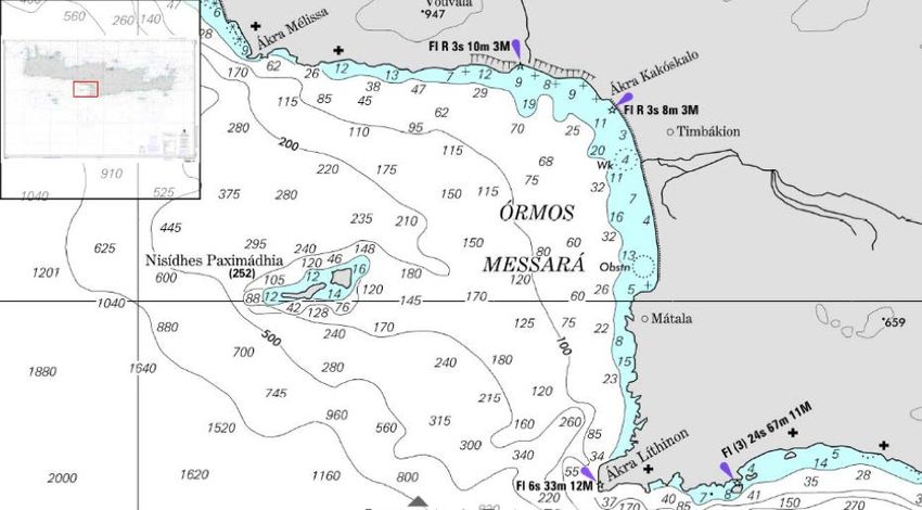
STATEMENT OF SIGNIFICANCE AND IMPACT
 Maritime Landscapes of Southern Crete from the Paleolithic to Modern Times: The Gulf
                           of Messara Underwater Survey

        This proposal seeks to gain funding for a major three-year collaborative research project
aimed at characterizing the maritime landscapes of southern Crete from the island’s earliest
human presence to the expulsion of the Ottomans at the very end of the 19th century CE. The
maritime significance of Crete was already established in Greek oral tradition by the time the
Iliad and Odyssey were first written down sometime in the 8th century BCE. Clues about the
island’s seafaring history derived from such sources as Bronze Age wall paintings and New
Testament scripture have provided the basis for much scholarly speculation, but ultimately leave
many questions about the long-term development of maritime culture on the island unanswered.
A recent debate among Mediterranean archaeologists was prompted by the discovery of lithic
artifacts in southern Crete dated to the Paleolithic, which have the potential to push back the
earliest human presence on Crete, as well as the earliest demonstrable hominin sea-crossings in
the Mediterranean, to around 130,000 years ago.
        The project team will conduct an underwater survey of the Gulf of Messara, collecting
data through both diver reconnaissance and remote sensing in order to ascertain the long-term
history of social complexity, resource exploitation, and island connectivity. Located on the Gulf
of Messara, which is located at the western edge of the Messara Plain in the center of Crete’s
southern coast, are the Roman port of Matala, the Minoan harbor town of Kommos, and the site
of Plakias where the aforementioned lithics tentatively dated to the Middle Paleolithic were
discovered. Interdisciplinary land-based surveys conducted in the Messara Plain provide a strong
basis of interpretation for the social dynamics of the region. The proposed underwater survey,
through simultaneous collection of cultural and environmental data, will help clarify processes of
colonization and trade, as well as provide a fuller picture of maritime landscapes as they existed
in different periods.
        This project will bring together scholars and professionals from the United States,
Turkey, Greece, Canada, and Israel, and will involve collaboration between the Institute of
Nautical Archaeology (INA), the Greek Ephorate of Underwater Antiquities, and the Joukowsky
Institute of Archaeology and the Ancient World located at Brown University. Using INA’s
newly built Virazon II, the first vessel anywhere in the world to be classed as an Archaeological
Research Vessel, the team will collect data of various types, including multibeam sonar data,
bathymetry, sub-bottom profiles, and core samples.
        Our research will contribute to the humanities by investigating the variety of human
responses over time to a changing landscape. In addition to producing environmental and
archaeological data to that effect, this project will also help contextualize the conception of place
in the past by providing possible explanations for depictions in literature of the Gulf of Messara
as a hazardous waypoint. The dissemination of our results will target both professionals and the
public using both digital and print media. We will share our work with colleagues around the
world at various conferences and symposia, submit articles for publication to top peer-reviewed
journals, and produce video documentation of our progress over the course of all three field
seasons.

                                                 ii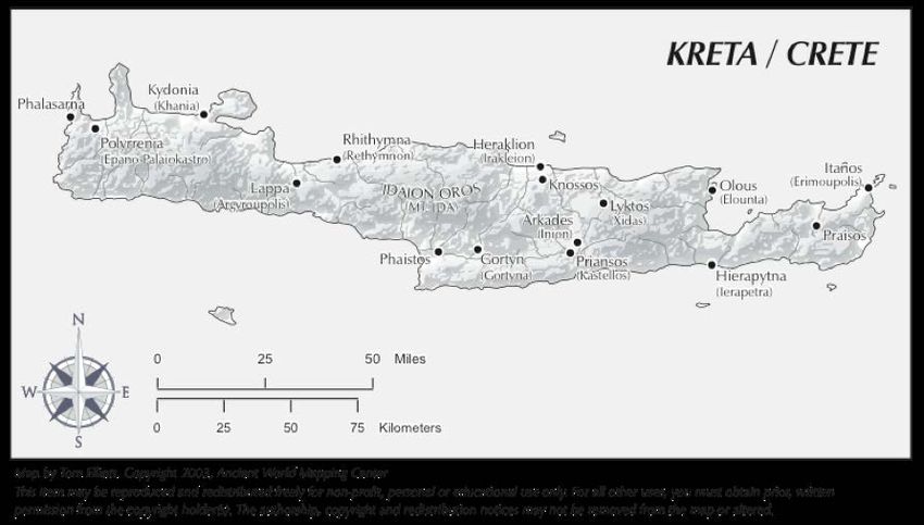
TABLE OF CONTENTS
 Maritime Landscapes of Southern Crete from the Paleolithic to Modern Times: The Gulf
                           of Messara Underwater Survey

Cover Sheet ...................................................................................................................................... i
Statement of Significance and Impact ............................................................................................ ii

Table of Contents ........................................................................................................................... iii

List of Participants ......................................................................................................................... iv

Project Narrative

       Substance and Context

           Justification ..........................................................................................................................1

           Research Questions ..............................................................................................................5

           The Survey Area ..................................................................................................................8

           Contributions of the Humanities ........................................................................................11

       Collaborators ..........................................................................................................................12

       Methods ..................................................................................................................................15

       Work Plan ...............................................................................................................................18

       Final Products and Dissemination ..........................................................................................18

Project Budget

       Budget Form ...........................................................................................................................20

       Budget Justification ................................................................................................................23

Appendices

       Appendix A: Bibliography .....................................................................................................26

       Appendix B: Permitting Procedures .......................................................................................29

       Appendix C: Figures...............................................................................................................30

                                                                        iii
LIST OF PARTICIPANTS

Project Director

Krusell, Karl
Joukowsky Institute for Archaeology and the Ancient World, Brown University
Project Co-PI

Köyağasıoğlu, Orkan
Bodrum Research Center, Institute of Nautical Archaeology
Project Co-PI

Collaborators

Goodman, Beverly
University of Haifa
Geoarchaeological Specialist

Lawall, Mark
University of Manitoba; American School of Classical Studies at Athens
Ceramics Specialist

Littlefield, John
Bodrum Research Center, Institute of Nautical Archaeology
Diving Safety Officer, Archaeological Consultant

Theodoulou, Theotokis
Non-Independent Office of the Ephorate of Underwater Antiquities, Crete
Remote Sensing Specialist, Archaeological Consultant

Additional Team Members

Gül, Zafer
Bodrum Research Center, Institute of Nautical Archaeology
Virazon II Captain

Snowden-Smith, Susannah
Freelance professional
Photographer and Videographer

                                              iv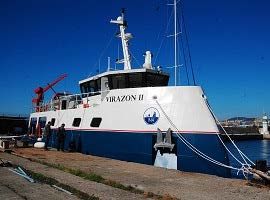
PROJECT NARRATIVE
    Maritime Landscapes of Southern Crete from the Paleolithic to Modern Times: The Gulf
                              of Messara Underwater Survey

                                          Substance and Context

Justification

          Crete, the largest of the Greek islands, separates the Aegean and Libyan Seas, and is in

many respects like a miniature continent (Fig. 1). This relatively small land mass contains the

full range of Mediterranean topography, including snow-capped mountains, sandy beaches,

fertile plains, and arid valleys. Crete’s placement within the Mediterranean has led to its role as a

cultural crossroads between Europe, Asia, and Africa for at least the past several millennia. The

island also lies at the crossroads of history and myth. When Sir Arthur Evans discovered the

oldest known European civilization at the turn of the 20th century, he named the people and their

culture Minoan after the legendary king Minos of Crete. The ancient historian Thucydides,

writing in the 5th century BCE, reported that Minos, who is mentioned in the Homeric epics (Il.

13.450; Od. 11.321), established the first navy, extinguished piracy in the Aegean, and colonized

the Cyclades (Thuc. 1.4).

          Though this notion of Minoan thalassocracy (i.e. naval supremacy) is certainly

exaggerated, evidence exists that the Minoans were trading goods and exchanging skilled

craftsmen with the Egyptians, 1 and that they were colonizing or at least exporting their cultural

traditions and artistic conventions to Thera and other Cycladic islands. 2 Our only evidence for

1
    Wachsmann 1987; Bietak et al. 2007.
2
    Doumas 1992.

                                                   1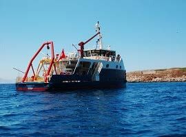
Minoan ships survives in the form of wall frescoes, boat models, 3 and the monumental ship

sheds at Kommos. 4 The discovery of a Minoan shipwreck has long been the “holy grail” for

scholars like Shelley Wachsmann of Texas A&M University, 5 who directed the Danaos

Deepwater Survey Project (2007–2009) which searched along a hypothesized trade route

between Crete and Egypt. 6 The Danaos Project failed to yield any Minoan artifacts, but the team

recorded numerous ceramic vessels on the seabed, both in isolation and as part of supposed trails

of jettisoned cargo. While this project was nominally diachronic, its primary goal was to look for

evidence of contacts between Crete and Egypt during the Bronze Age, and so it resembled more

of a “search” than a “survey.” 7

       A more recent survey known simply as the Crete Underwater Survey was much more

committed to a diachronic research design. It was run by the Woods Hole Oceanographic

Institute (WHOI) and surveyed in different areas along the northern and western coasts of Crete,

between the city of Heraklion and the island of Dia (2011), and between western Crete and the

island of Antikythera (2013). In 2011 alone they discovered eight shipwrecks (five ancient and

three modern) as well as three anchorages. 8 The former survey area was chosen for three

principal reasons: 1) the area of Heraklion had served as the capital of Crete for most of the past

four millennia, except for when it was temporarily moved to Gortyn in the south during the

Roman period, 2) the area lacked a naturally protected bay and was thus continuously exposed to

north winds, and 3) archaeological material had been found in the area of Dia since an expedition

3
  Wachsmann 1998, 104–5.
4
  Shaw and Shaw 2006.
5
  Marchant 2012, 426.
6
  Wachsmann et al. 2009.
7
  Søreide 2011, 101.
8
  Theodoulou et al. 2011.

                                                 2
in 1976 by Jacques Cousteau, suggesting that a systematic survey would prove fruitful. Our
survey area has been chosen for similar reasons:
1) The Gulf of Messara is home to known harbor sites from different periods. Under
the Romans, Gortyn became the capitol of the joint province Creta et Cyrenaica, and
Matala became its port, supplying Rome with grain grown in the Messara plain. The
nearby site of Kommos, which dates to the Bronze Age, is home to monumental ship
sheds which would have been used to keep ships protected when not in use. The harbor
town of Kommos was part of the so-called Great Minoan Triangle in south central Crete,
which also included the palatial complex at Phaistos and the elite villa at Ayia Triada
(Fig. 2).
2) The sailing conditions in the Gulf of Messara can be hazardous. The Gulf of Messara
has served as the setting for suspenseful seafaring narratives in at least two works of
ancient literature, including Book 3 of the Odyssey, in which half of Menelaos’ fleet is
broken up against the headland near Phaistos by a strong south wind (Od. 3.285-300),
and chapter 27 of Acts of the Apostles, in which the ship carrying Paul was blown off
course by a northeast hurricane wind (Gk. typhonikos, cf. “typhoon”) to the island of
Gavdos while sailing through the Gulf of Messara from Kaloi Limenes (the so-called
“Fair Havens”) to the ancient Cretan port town of Phoenix (Acts 27.8-16). On the other
hand, one ancient source suggests that the route along the south coast of Crete was
preferable to a northern route through the Sea of Crete (Lucien Nav. 9), suggesting that
the area was heavily trafficked. Joseph Shaw, who served as the principal investigator of
the Kommos excavations for several decades, suspected that “surely there are deepwater
wrecks there that would more than repay investigation, of ships that were beating up
3against the wind, attempting to reach the Matala or Kommos harbors, but were crushed
against projecting cliffs.” 9
3) Additional material evidence points to diverse maritime activities in the area. In
1955, the British School recorded a Roman period shipwreck near the bay of Ayia Galini
which had contained a cargo of bronze statuary. 10 More wrecks of this type, as Shaw
rightly suspected, could be found in the deeper waters off the Gulf of Messara if surveyed
with the appropriate methods and tools. But in recent years discussions about the
maritime history of Crete have been dominated by the possibility of hominin dispersals
by sea during the Lower Paleolithic and the characterization of different degrees of island
colonization. 11 This discussion has largely been prompted by the discovery of stone tools
from Plakias and Loutro, both sites on the southwest coast of Crete, which possibly date
to the Middle Paleolithic or approximately 130 kya. 12 Aside from these recent
discoveries, the earliest verified evidence for a human presence on Crete comes from the
aceramic Neolithic strata at Knossos, which date to the 7th millennium BCE. 13 Skeptics
have pointed out that the Paleolithic dates for the lithics from Plakias are extrapolated
from geologic deposits, and that the quartz from which the tools are made is difficult to
evaluate because it does not flake as cleanly as chert, flint, or obsidian. The only way to
advance this dialogue is through further study, particularly of the coastal and underwater
landscape off southern Crete.
9
Shaw 2006, 59.
10
Leatham and Hood 1958/59, 278–280.
11
Runnels 2014; Leppard 2014.
12
Mortensen 2008; Strasser et al. 2010; Strasser et al. 2011.
13
Broodbank 2008; Broodbank and Strasser 1991.
4Previous land-based archaeological surveys in the Messara region, particularly in the
hinterlands of Kommos and Phaistos, have gone a long way toward characterizing the maritime
aspects of cultural landscapes. 14 But no matter the strength of the data generated by land-based
survey and excavation, the picture of the maritime landscape is incomplete without systematic
survey data of the underwater environment. The Gulf of Messara Underwater Survey aims to
shed light on the maritime aspects of social complexity in south central Crete from as far back as
the Paleolithic to the modern period.
Research Questions
This project will employ advanced remote sensing and imaging technologies to
corroborate previous library and museum research and to inform future studies and fieldwork. In
terms of data collection, the goals of the project are to record the most detailed environmental
data to date of the survey zone, including bathymetry and sub-bottom stratigraphy, and to locate
and map all discernable cultural material on the seabed, including shipwrecks, cargoes, and
associated artifacts. Our team will follow a research plan designed to address the following
questions about the survey zone:
1) How has the long-term geological history of the Gulf of Messara affected human
activities in the area? The Gulf of Messara is a seismically active area and has been
throughout antiquity. Subduction of the Africa plate beneath the relatively small Aegean
Sea plate results in shallow-focus earthquakes along the Hellenic arc plate boundary.
Historical records and land excavations have determined that two 7.2 magnitude
earthquakes centered near Crete occurred in 365 CE and 1303 CE. 15 Previous research
14
Blackman and Branigan 1975, 1977; Hope Simpson et al. 1995; Watrous et al. 2004.
15
Fytikas and Vougioukalakis 2005.
5has shown that the western half of the island exhibits between 2–9 m of coastal uplift,
while the eastern half exhibits varied levels of subsidence. 16 However, the effects of
seismic activity and sea-level rise are less clear on the south-central coasts of Crete. Crete
has been a “true” island—i.e. separated from the continental mainland—since the
Messenian Salinity Crisis between 5.96–5.33 mya, when the Strait of Gibraltar
reopened. 17 Assuming that the material from Plakias indeed dates to the Paleolithic,
researchers much attempt to determine the nature of this demonstrated human presence,
i.e. whether it represents maritime activity that was purposeful, organized, and planned or
seasonal, episodic, or even accidental. The geological data collected during the proposed
survey will be used to reconstruct the ancient coastlines and foreshore environment,
including sources of fresh water. In addition to elucidating the relationship between
ancient peoples and their environments, these newly-collected geological data will also
refine our understanding of the limits of said data. For instance, seabed sedimentation
rates are not clearly known for the Gulf of Messara, into which two rivers—the Platis and
the Ieropotamos—empty their contents. For these reasons, the ancient seabed may not be
exposed enough to yield the archaeological information we seek. It is our hope that the
sub-bottom profiler data will help determine how sedimentation and seismic activity have
shaped the seafloor over time, and thus inform future studies, both geological and
archaeological, of this region.
16
Pirazzoli et al. 1982; Flemming 1978.
17
Krijgsman et al. 1999.
62) Was does the distribution of cultural material below the surface of the Gulf of
Messara suggest about ancient seafaring and trade, and how does it relate to other
underwater surveys in the Mediterranean? Two famous literary characters, Menelaos
and Paul, experienced disaster or near-disaster at sea here, suggesting that the Gulf of
Messara was considered treacherous for sailing ships, at least for part of the year. Can we
substantiate this reputation with evidence of shipwrecks or jettisoned cargo? Or is the
hazardous nature of the Gulf as depicted a literary invention, and the common setting for
these narratives a coincidence? It is possible that sedimentation and tectonic shifts of the
seabed will mask the ancient seafloor to such an extent that we cannot make a
determination. Based on the literary sources and nearby land excavations, we expect to
find the greatest amount of material culture from the Roman occupation of Crete. But to
what extent will the various ancient populations of Crete—Minoans, Greeks, Romans,
Byzantines, Arabs, Venetians, and Ottomans—be represented on the seafloor and what
will that data reveal about the details of social complexity and cultural contact? What
ancient trade networks are discernable from the assemblages? How does the commercial
importance of Crete’s southern coast change through time?
3) Does the underwater cultural material from the Gulf of Messara reinforce,
contradict, or otherwise complicate the narratives derived from historical sources
and land-based archaeological survey and excavation? At least three pedestrian field
surveys have taken place in the coastal areas of Phaistos, Kommos, Matala, and Kaloi
Limenes. The area south of Matala and directly west of Kaloi Limenes was surveyed
between 1971 and 1972 by David Blackman and Keith Branigan. 18 The Kommos Survey,
18
Blackman and Branigan 1975, 1977.
7which took place between 1977 and 1979, was associated with the excavation of the
Minoan harbor town of Kommos by Joseph and Maria Shaw. 19 Most recently, the
Western Messara Project undertook an interdisciplinary regional field survey directed by
L. Vance Watrous and Despoina Hadzi-Vallianou between 1984 and 1987. 20 The Gulf of
Messara Underwater Survey aims to advance these former studies by shedding light on
the maritime aspects of social complexity in south central Crete from as far back as the
Paleolithic to the modern period.
The Survey Area
The Gulf of Messara is formed by a large indentation in the middle of Crete’s southern
coast, bounded to the east by the north-south terminus of the Messara Plain and to the north by
the east-west coastline of the Rethymno regional unit. To its west and south the Gulf opens up to
the Libyan Sea. Moving from east to west along the southern coast of Crete, the shoreline makes
a sharp right turn at Cape Lithinos and continues on a roughly north-south axis for about 18 km
until, at the small coastal community of Kokkinos Pyrgos, it turns left and resumes its east-west
axis until it reaches the small island of Elafonisi in the southwest corner of Crete and turns right
again, rounding the western coast of Crete. The eastern boundary of the Gulf of Messara is where
the north-west coast of the western Messara plain meets the Libyan Sea and lies approximately
along latitude 24°10’ E. This stretch of land, which contains steep cliffs in the south, consists
mostly of open beaches. The Gulf’s northern boundary is formed by the east-west southern
coastline of the Rethymno regional unit, from Kokkinos Pyrgos to Agios Pavlos. Thus, the Gulf
of Messara forms a rough right angle. Situated in the middle of the Gulf’s western boundary are
19
Hope Simpson et al. 1995.
20
Watrous et al. 2004.
8the uninhabited twin islands known collectively as Paximadia. Ancient ships travelling from the
eastern Mediterranean (Egypt or the Levant) to the Peloponnese, Sicily, Italy, or beyond would
have potentially sailed right past the Gulf of Messara, as did the ship that was carrying Paul from
Jerusalem to Rome (Acts 27). The entire Gulf comprises about 220 km2, which we propose to
map and survey in our first season.
Seafloor Terrain
The waters remain relatively shallow some distance from the shore, but eventually drop
past 50 m, with the result that the deepest area of the gulf is the southwestern corner of the
proposed survey zone, at about 350 m (Figs. 3 & 4). The topography is gradual and homogenous,
making this area suitable for a sonar survey (Figs. 5 & 6). The drop off is much steeper in the
southernmost portion of the survey area.
Seafloor Sediment
Two Cretan rivers empty their waters into the Gulf of Messara. The Platis River flows
south from Mount Kedros and exits at the beach in Agia Galini, and the Ieropotamos River
waters the Messara Plain before exiting near the military airport of Tympaki at the eastern edge
of the Gulf. While sediment studies have been done on the riverbeds of the Messara basin and on
the shallower waters of the Gulf of Messara, 21 little is known about the nature of seafloor
sediments in the middle of the Gulf. The exact makeup of sediments will likely vary within the
survey zone, but we expect a combination of course conglomerate and sandstones and fine-
grained fluvial sediments (sandstone and mudstone). It’s quite possible that sedimentation rates
21
Reuter and Brachert 2007.
9in the Gulf are high, causing any archaeological material to be buried deeply. If such is the case,
sub-bottom profiles will help inform future approaches to these problems.
Prevailing Winds and Currents
Northwestern trade winds drive diagonal waves upon the north-south coast of the western
Messara in the summer 22 and in the winter west winds pile larger waves upon the long open
beaches. 23 Our literary sources tell of a south or southwest wind (notos) (Od. 3.295) and
northeastern (eurakulon) storm wind (Acts 27.14) making trouble for ancient mariners in this
area. From June to October frequent northerly gales strike the Gulf with great violence. 24 These
etesians or meltemi are probably what drove Paul’s ship southward in Acts of the Apostles, as he
was sailing after the “fast” or Yom Kippur, which occurs in late September. These winds, which
blow down from Psiloritis or Mt. Ida, only become more violent in winter. For this reason, the
eastern coast of the Gulf of Messara is not good for wintering, which is likely why the
inhabitants of Kommos built ship sheds far back from the shore to accommodate their vessels
during the “non-sailing” months. 25 This is also why the area immediately south of the Gulf of
Messara, known appropriately as Kaloi Limenes or Fair Havens (lit. “good harbors”), is a more
suitable anchorage for ships both ancient and modern. This area experiences moderate and steady
breezes, while the Gulf hosts violent gales, especially in the mornings. Along the south of Crete
is a west-setting current that may reach a speed of 1.5 knots off the promontories, yet the waters
within the Gulf are stiller. Of greater concern than the currents are the somewhat unpredictable
hurricane-like gales from the north (meltemi).
22
Casson 1995, 272.
23
Shaw 2006, 51.
24
Le Gras 1870, 160.
25
Shaw 2006, 124–125.
10Surface Hazards
Violent northerly winds are even more dangerous when taken in combination with the
rocky shoreline of the southern headland from Matala to Cape Lithinos. Such were the factors
that cost Menelaos half of his fleet. While occasional offshore reefs, such as the one off Kommos
which is known locally as papadoplaka (“the priest’s slab”), 26 act as navigational hazards to be
avoided, they also dissipate the strength of the waves and provide shelter for anchorage along an
otherwise unprotected beach. Conducive to the goals of this project is the relative absence of
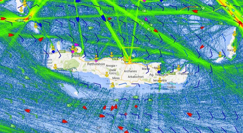
marine traffic within the Gulf of Messara. As can be seen in Fig. 4, the density clouds
representing ship traffic around Crete conveniently pass by the proposed survey zone.
Contributions to the Humanities
Our research will contribute to the humanities by investigating the variety of human
responses to a changing coastal landscape and the associated changes over time to social
networks. Our diachronic research design will produce data to reconstruct ancient coastlines and
environments, but will avoid models that privilege environmental determinism to explain cultural
change. Our data will show how the maritime landscape of south-central Crete simultaneously
shaped and was shaped by human activity. This project will also help contextualize human
conceptions of place by seeking to understand the associations past peoples made with the Gulf
of Messara, including literary depictions of the Gulf as a hazardous waypoint. Studies based on
world systems theory treat population centers such as Phaistos and Gortyn and harbor complexes
such as Kommos and Matala as “core” sites and the smaller agricultural villages surrounding
them as “peripheral” sites. Our project will extend the concept of “periphery” to the sea itself.
26
Shaw 2006, 55.
11While the circumstances of deposition for cultural material found underwater often differ from
those for land sites, there remains great potential in attempts to measure the maritime reach of
core sites, by detecting cargoes that failed to reach their intended destinations.
Collaborators
The Gulf of Messara Underwater Survey is a collaboration of the Joukowsky Institute for
Archaeology and the Ancient World at Brown University in Providence, Rhode Island and the
Institute of Nautical Archaeology (INA), headquartered at Texas A&M University in College
Station, Texas, and is to be conducted in cooperation with the Department of Underwater
Antiquities of Crete, a non-independent office of the Ephorate of Underwater Antiquities (a
Special Peripheral Service of the Hellenic Ministry of Culture and Sports). Apart from the 8 core
team members listed below, an additional 9 supporting staff are to be recruited at a later date, for
a total of 17 team members.
Project Directors
♦ Karl Krusell will serve at the co-Principal Investigator for the proposed NEH-funded
research. He is a PhD student in the Joukowksy Institute for Archaeology and the Ancient
World at Brown University, and specializes in shipwreck and harbor archaeology in the
Aegean and eastern Mediterranean. He will supervise the remote sensing survey,
mapping, and database management, a time commitment of 90 days per year for the
duration of the project.
♦ Orkan Köyağasıoğlu will serve at the other co-Principal Investigator for the proposed
NEH-funded research. He serves as a staff archaeologist for the Institute of Nautical
Archaeology, and has participated in many surveys and shipwreck excavations in Turkey,
12including the projects at Tektaş Burnu, Cape Gelidonya, Yenikapı, Kızılburun, and Pabuç
Burnu. He pilots INA’s research submersible Carolyn, and serves as a crewmember
aboard Virazon II. He will supervise the diver surveys, manage shipboard logistics and
provisioning, and direct artifact conservation, a time commitment of 90 days per year for
the duration of the project.
Collaborators
♦ Beverly Goodman will serve as the project’s geoarchaeological specialist. An assistant
professor in the Department of Marine Geosciences at the Leon Charney School of
Marine Sciences, University of Haifa, Israel, where she manages the Marine
Geoarchaeology and Micropaleontology Laboratory, her research focuses on the
reconstruction of ancient harbors, and the effects of tsunami events on coastal
environments and human societies. Dr. Goodman will take charge of collecting
environmental samples in the field, analyzing them at the laboratory at the University of
Haifa, and producing visualizations of the raw data. There will be room on the research
vessel for her to bring two graduate student assistants. Time commitment: 2 weeks per
field season and the equivalent of 4 weeks per academic year to analyze the samples and
prepare reports of the results.
♦ Mark Lawall will serve as the project’s ceramics specialist. He is a Professor of Classics
at the University of Manitoba and serves as Chair of the Managing Committee of the
American School of Classical Studies at Athens. He is an expert in ancient economic
history with a specialty in Mediterranean transport amphoras. He will assist with ceramic
identifications and dating. Time commitment: the duration of each field season and the
13equivalent of 4 weeks per academic year to refine and prepare his analysis for
publication.
♦ John Littlefield will serve as the project’s diving safety officer and as an archaeological
consultant. He is a PhD candidate in the Nautical Archaeology Program at Texas A&M
University, and works as an archaeometry specialist at the Institute of Nautical
Archaeology’s Bodrum Research Center. He has extensive diving experience in the
Mediterranean and is a certified scuba instructor. He will conduct certification and diving
insurance compliance checks, manage the diving logs and equipment inventory, and
oversee the maintenance of the air compressors and recompression chamber. Time
commitment: the duration of each field season and the equivalent of 2 weeks per year to
prepare and conclude each field season. There will be room on the vessel for him to
recruit three archaeological divers to serve for the duration of each field season.
♦ Theotokis Theodoulou will serve as the project’s remote sensing specialist and as an
archaeological consultant. He heads the Non-Independent Office at Crete for the Greek
Ephorate of Underwater Antiquities. He has extensive experience in underwater
archaeology, and has previously worked on successful underwater surveys off the coast
of Crete. He will direct the deployment of remote sensing equipment and associated data
collection, as well as advise on various archaeological and scientific matters. Time
commitment: the duration of each field season and the equivalent of 4 weeks per year to
process data, produce visualizations, and prepare data for publication. There will be room
on the research vessel for him to bring one colleague to participate for the duration of
each field season.
14Additional Team Members
♦ Zafer Gül will serve as the captain of our research vessel, Virazon II. He previously
served as captain of the original Virazon for over a decade. His duties will include
piloting the vessel, overseeing engine and systems maintenance, and managing radio
communications and berthing logistics. He will hire three additional crewmembers per
year, including a cook, to serve for the duration of the field season. Time commitment:
the duration of each field season and the equivalent of 2 week per year for hiring
additional crewmembers, making preparations for departure, and concluding each
season’s expedition.
♦ Susannah Snowden-Smith will serve as the project’s photographer and videographer.
She has extensive experience with underwater photography and has served previously as
a photographer for several of INA’s past shipwreck excavations. In addition to artifact
photos, she will document the diver surveys and daily operations aboard the research
vessel. Time commitment: the duration of each field season as well as the equivalent of 2
weeks per year to process, edit, and catalogue photographs and footage.
Methods
For all three field seasons, the project’s base of operations will be Virazon II, the Institute
of Nautical Archaeology’s recently built 25 m research vessel, which is the first ship anywhere in
the world to be classed as an Archaeological Research Vessel (Fig. 5). The ship is equipped with
bottom-scan sonar and a 5-ton A-frame for lifting INA’s 2-person submersible Carolyn. It also
houses a recompression chamber and high- and low-pressure compressors. The ship has a
cruising speed of 10 knots, powered by twin 425 HP engines. It has space to accommodate 19
15crewmembers, researchers, and passengers, with 16 bunk beds in the main cabin on the lower
deck, a two-person VIP cabin, and a captain’s cabin.
The vessel’s home port is Yalikavak Marina, just west of Bodrum. The team will meet in
Bodrum at the Institute of Nautical Archaeology’s research center, and will stay at the
dormitories there as the team prepares for departure. There is currently no permanent crew
assigned to the vessel, so temporary crew members will be hired each season. Family, friends,
and colleagues will be about to monitor our progress and track the vessel’s latest position by
following this web link.
The Gulf of Messara Underwater Survey will focus on one area per field season. In the
first field season, we will focus on the northern coast of the Gulf from Kokkinos Pyrgos to Agios
Pavlos (Zone 1). The survey zone will be approximately 16 km long and 2.5 km wide, for a total
area of about 40 km2. In the second season, we will focus of the eastern coast of the Gulf from
Kokkinos Pyrgos to Agiofarago (Zone 2), with a survey zone approximately the same 40 km2
size. In the third season, we will focus on the Paximadia islands in the southwest of the Gulf
(Zone 3). The survey zone will include the first 1.5 km of water surrounding the islands, an area
of about 20 km2. In total, the project team will collect detailed, high-resolution data for about
100 km2 of sea across three field seasons.
The survey team will collect bathymetric data using Virazon II’s hull-mounted multi-
beam sonar system. At the same time, we will tow INA’s magnetometer and sub-bottom profiler
behind the vessel. In the final season, in addition to surveying around the Paximadia islands, we
will deploy a SeaBED-class AUV to investigate and image the targets defined in previous
16seasons. 27 This type of AUV consists of a positively buoyant upper hull and a negatively buoyant
lower hull connected by aluminum spars, a design that provides enhanced stability for low-speed
photographic and acoustic bathymetric surveys a few meters above the seafloor. The SeaBED
AUVs are equipped with an Imagenex Delta-T imaging sonar for bathymetric capture, HDR
(High Dynamic Range) Prosilica cameras, a SeaBird CTD (Conductivity, Temperature, and
Depth) sensor for measuring salinity and water temperature, and an EdgeTech 2200 M sub-
bottom profiler, which will use a CHIRP signal in the 4–24 kHz range to penetrate several dozen
meters into the seabed for stratigraphic data.
Across all three seasons, we will also run diver surveys nearer to the coast to investigate
areas of interest based on archival and historical research, as well as interviews with local
fisherman and divers. Remote sensing targets within the safe diving zone may also be
groundtruthed by divers before the AUV is deployed. Some conservation measures will be
required if targeted collection is deemed necessary, though the default heritage preservation
approach for this project will be to leave artifacts in situ. Beverly Goodman and her two graduate
students will collect about 6 core samples from the seabed each field season using their own
equipment, and will transport them back to the University of Haifa for analysis. With our
combined data sets, we will be able to reconstruct the ancient shorelines of the Gulf of Messara
and the Paximadia islands, as well as quantify and qualify the cultural material found underwater
in the survey zones.
27
See Foley et al. 2009 for more information of the SeaBED AUVs.
17Work Plan
Summer Fieldwork (July) Academic Year Labwork Dissemination
Year 1 (June 2019 – ♦ Remote sensing survey ♦ Core sample analysis ♦ Write field report
November 2019) of Zone 1 ♦ Remote sensing data (August)
♦ Diver survey of Zone 1 processing ♦ Post footage from first
♦ Core sampling in Zone ♦ field season online
1 (October)
Year 1 (December 2019 – ♦ Data management ♦ Conference
May 2020) ♦ Artifact conservation presentation at SHA
(?) (January)
♦ Journal article on
survey methodology
aboard Virazon II
(April)
Year 2 (June 2020 – ♦ Remote sensing survey ♦ Core sample analysis ♦ Write field report
November 2020) of Zone 2 ♦ Remote sensing data (August)
♦ Diver survey of Zone 2 processing ♦ Post footage from
♦ Core sampling in Zone second field season
2 online (October)
Year 2 (December 2020 – ♦ Data management ♦ Conference
May 2021) ♦ Artifact conservation presentation at AIA
(?) (January)
♦ Journal article on
results of diver surveys
(April)
Year 3 (June 2021 – ♦ Remote sensing survey ♦ Core sample analysis ♦ Write field report
November 2021) of Zone 3 ♦ Remote sensing data (August)
♦ Diver survey of Zone 3 processing ♦ Post footage from third
♦ Core sampling in Zone field season online
3 (October)
♦ AUV groundtruthing
in Zone’s 1, 2, and 3
Year 3 (December 2021 – ♦ Data management ♦ Journal article on
May 2022) ♦ Artifact conservation geoarchaeological
(?) results (January)
♦ Journal article on
project summary
(April)
Final Products and Dissemination
The dissemination of our results will target both professionals and the public using both
digital and print media. Preliminary results of the survey will be reported to the Ephorate of
18Underwater Antiquities and the Institute of Nautical Archaeology within six weeks of the end of
the field season. The project’s results will be shared with colleagues around the world at various
conferences and symposia. After the third season of survey, final results will be submitted for
publication to top peer-reviewed journals such as the International Journal of Nautical
Archaeology, Hesperia, and the Journal of Mediterranean Archaeology. Digitally captured
photographs and footage with be used to produce an in-house documentary to be uploaded and
made available for free on our project website.
19OMB No 3136-0134
Budget Form Expires 6/30/2018
Applicant Institution: Brown University
Project Director: Karl Krusell
click for Budget Instructions Project Grant Period: 06/01/2019 through 05/31/2022
Computational
Details/Notes (notes) Year 1 (notes) Year 2 (notes) Year 3 Project Total
06/01/2019- 06/01/2020- 06/01/2021-
05/31/2020 05/31/2021 05/31/2022
1. Salaries & Wages
Academic Year Salary:
Project Director, Karl Krusell $30,000 25% $7,500 % $7,500 % $7,500 $22,500
Co-PI, Orkan Köyağasıoğlu Salary: $43,500 25% $10,875 $10,875 $10,875 $32,625
Virazon II Captain, Zafer Gül Salary: $47,500 12% $5,700 $5,700 $5,700 $17,100
Virazon II crewmembers [3] $788/week [3] 100% $9,456 % $9,456 % $9,456 $28,368
Photographer, Susannah Avergae annual income:
Snowden-Smith $39,000 12% $4,680 % $4,680 % $4,680 $14,040
2. Fringe Benefits
Krusell 31% $2,325 $2,325 $2,325 $6,975
Köyağasıoğlu 12% $1,305 $1,305 $1,305 $3,915
Gül 36% $2,052 $2,052 $2,052 $6,156
3. Consultant Fees
Geoarchaeological Specialist, Analysis of core samples.
Beverly Goodman Fee: $1000/week 4 weeks $4,000 $4,000 $4,000 $12,000
Processing and
preparation of remote
Remote Sensing Specialist, sensing date. Fee:
Theotokis Thedoulou $1000/week 4 weeks $4,000 $4,000 $4,000 $12,000
4. Travel
20Roundtrip airfare and excess
baggage fees for Karl Krusell Flight from Boston to
(co-PI) Bodrum $1,700 $1,700 $1,700 $5,100
Roundtrip airfare for Mark Flight from Winnipeg to
Lawall (ceramics specialist) Bodrum $1,800 $1,800 $1,800 $5,400
Roundtrip airfare and excess
baggage fees for Susannah
Snowden-Smith Flight from Grand
(photographer) Cayman to Bodrum $2,200 $2,200 $2,200 $6,600
Roundtrip airfare and excess
baggage fees for Beverly
Goodman (geoarchaeological Flight from Haifa to
specialist) Bodrum $400 $400 $400 $1,200
5. Supplies & Materials
Fuel for research vessel, air $5/gallon @ 360 gallons
compressors, and generators per day $54,000 $54,000 $54,000 $162,000
Project computers $1200 [2] $2,400 $2,400
External hard drives 2 TB [3] @ $100 $300 $300
Storage bins, cleaning
brushes, plastic bags,
Conservation materials acetate labels $250 $250
6. Services
International mobile data x 3
(Krusell, Lawall, Snowden-
Smith) 4 weeks [2], 8 weeks [1] $400 $400 $400 $1,200
AUV rental and remote
technical support 4 weeks $16,361 $16,361
Docking fees $49/day $1,470 $1,470 $1,470 $4,410
7. Other Costs
21Food for meals cooked
onboard daily ($10 per
day/per person @ 17
Food people) $5,100 $5,100 $5,100 $15,300
8. Total Direct Costs Per Year $121,913 $118,963 $135,324 $376,200
9. Total Indirect Costs
Per Year $0 $0 $0 $0
10. Total Project Costs (Direct and Indirect costs for entire project) $376,200
11. Project Funding a. Requested from NEH Outright: $250,000
Federal Matching Funds: $0
TOTAL REQUESTED FROM NEH: $250,000
b. Cost Sharing Applicant's Contributions: $1,200
Third-Party Contributions: $125,000
Project Income: $0
Other Federal Agencies: $0
TOTAL COST SHARING: $126,200
12. Total Project Funding $376,200
Total Project Costs must be equal to Total Project Funding ----> ( $376,200 = $376,200 ?)
Third-Party Contributions must be
greater than or equal to Requested Federal Matching Funds ----> ( $125,000 ≥ $0 ?)
22Budget Justification
1. Salaries and Wages
As co-PIs, Karl Krusell and Orkan Köyağasıoğlu will devote 25% of their annual
working hours to overseeing the work of this project. Virazon II Captain Zafer Gül will
devote 12% of his annual working hours to this project, and three crewmembers of his
choosing will be hired specifically to serve for the duration of this project at a rate of
$788 per week. Susannah Snowden-Smith is an unsalaried freelancer, whose average
annual income has been calculated on the basis of her tax returns from the past three
filing years. Total (Years 1–3): $114,633
2. Fringe Benefits
The listed fringe benefit rates have been determined by the participants’
respective employers. Gül’s benefit rate includes personal liability insurance. The three
crewmembers carry no fringe benefits, but will be covered under INA’s insurance. As a
freelancer, Snowden-Smith receives no fringe benefits. Total (Years 1–3): $17,046
3. Consultant Fees
Geoarchaeological Specialist Beverly Goodman and two graduate students will
spend two weeks in the field per season at no cost. After each field season, Goodman will
work for four weeks at a rate of $1000/week to analyze the geological samples she
collects. Remote Sensing Specialist Theotokis Thedoulou will participate in each field
season at no cost, but will work for four weeks per year at a rate of $1000/week to
process and prepare the remote sensing data. Total (Years 1–3): $24,000
234. Travel
Each field season roundtrip flights from Boston (Karl Krusell), Winnipeg (Mark
Lawall), Grand Cayman (Susannah Smith-Snowden), and Haifa (Beverly Goodman) to
Bodrum will be provided. Orkan Köyağasıoğlu, Zafer Gül, John Littlefield, and the three
Virazon II crewmembers will already be in Bodrum at the start of the project. Theotokis
Theodoulou will meet the team in Crete. The three archaeological divers recruited by
Littlefield and the two graduate students accompanying Goodman will be responsible for
securing their own funding or else covering their own travel costs. Total (Years 1–3):
$18,300
5. Supplies and Materials
Fuel for the research vessel constitutes the largest single expenditure in the project
budget. The fuel cost includes travel from Bodrum to Crete, performing survey swaths,
and powering the ventilation system, air compressors, and generators. Two project
computers will be used to run HYPACK software and four external hard drives will be
used to temporarily store and back up project data. Basic conservation materials will be
purchased in case it is deemed necessary for the archaeological dive teams to collect
artifacts. Long-term conservation of any collected artifacts will be performed by the
Greek Ephorate of Underwater Antiquities. Total (Years 1–3): $164,950
6. Services
The three team members travelling from the outside the Mediterranean (Krusell,
Lawall, Snowden-Smith) will be provided with international mobile data plans for the
duration of their time working on the project. An AUV (autonomous underwater vehicle)
will be rented for the final field season to groundtruth targets identified from the previous
24years’ data collection. This cost will include remote technical support for the duration of
the rental period. The project will reserve a dock slip for the research vessel each field
season at a rate of $50 per day. Total (Years 1–3): $21,971
7. Other Costs
The project team will sleep aboard Virazon II for the duration of the project, or
will otherwise stay at the Bodrum Research Center’s dormitories, and so the project will
be able to avoid hotel expenditures. Food for meals prepared onboard the vessel by a
cook is budgeted at $10 per day per person. Total (Years 1–3): $15,300
8. Total Direct Costs: $376,200
9. Total Indirect Costs: $0
10. Total Project Costs: $376,200
11. Project Funding
a. Total Requested from NEH: $250,000
b. Cost Sharing
Applicant’s Contributions: $1,200
♦ Karl Krusell will donate one computer ($1,200) to the project.
Third Party Contributions: $125,000
♦ Provided by the Institute of Nautical Archaeology’s Board of
Directors
Total Cost Sharing: $125,200
12. Total Project Funding: $376,200
25APPENDICES
Appendix A: Bibliography
Bietak, M., N. Marinatos, and C. Palivou. 2007. Taureador Scenes in Tell El-Dab'a (Avaris) and
Knossos. Vienna: Österreichische Akademie der Wissenschaften.
Blackman, D.J., and K. Branigan. 1975. “An Archaeological Survey on the South Coast of Crete,
between Ayiofarango and Chrisostomos.” The Annual of the British School at Athens
70:17–36.
Blackman, D.J., and K. Branigan, with contributions by A.R. Doe, D.C. Holmes, and J. Bintliff.
1977. “An Archaeological Survey of the Lower Catchment of the Ayiofarango Valley.”
The Annual of the British School at Athens 72:13–84.
Broodbank, C. 2008. “Long After Hippos, Well Before Palace: A Commentary on the Cultures
and Contexts of Neolithic Crete.” In Escaping the Labyrinth: The Cretan Neolithic in
Context, edited by V. Isaakidou and P.D. Tomkins, 273–290. Oxford: Oxbow Books.
Broodbank, C., and T.F. Strasser. 1991. “Migrant Farmers and the Neolithic Colonization of
Crete.” Antiquity 65:233–45.
Casson, L. 1995. Ships and Seamanship in the Ancient Wolrd. Rev. ed. Princeton, NJ: Princeton
University Press.
Doumas, C. 1992. The Wall-Paintings of Thera. Translated by A. Doumas. Athens: The Thera
Foundation – Petros M. Nomikos.
Flemming, N.C. 1978. “Holocene Eustatic Changes and Coastal Tectonics in the Northeast
Mediterranean: Implications for Models of Crustal Consumption.” Philosophical
Transactions of the Royal Society A 289:405–458.
Foley, B. et al. 2009. “The 2005 Chios Ancient Shipwreck Survey.” Hesperia 78:269–305.
Fytikas, M., and G.E. Vougioukalakis, eds. 2005. The South Aegean Active Volcanic Arc:
Present Knowledge and Future Perspectives. Amsterdam: Elsevier.
Hope Simpson, R., P.P. Betancourt, P.J. Callaghan, D.K. Harlan, J.W. Hayes, J.W. Shaw, M.C.
Shaw, and L.V. Watrous. 1995. “The Archaeological Survey of the Kommos Area.” In
Kommos: An Excavation on the South Coast of Crete. Vol. 1, The Kommos Region and
Houses of the Minoan Town. Part I: The Kommos Region, Ecology, and Minoan
Industries, edited by J.W. Shaw and M. Shaw, 325–402. Princeton: Princeton University
Press.
26Krijgsman, W., F.J. Hilgen, I. Raffi, F.J. Sierro, and D.S. Wilson. 1999. “Chronology, Causes,
and Progression of the Messinian Salinity Crisis.” Nature 400:652–655.
Le Gras, A. 1870. General Examination of the Mediterranean Sea, A Summary of Its Winds,
Currents, and Navigation. Translated by R. H. Wyman. Washington: Government
Printing Office.
Leatham, J., and S. Hood. 1958/59. “Sub-Marine Exploration in Crete, 1955.” The Annual of the
British School at Athens 53/54:263–280.
Leppard, T. 2014. “Modeling the Impacts of Mediterranean Island Colonization by Archaic
Hominins: The Likelihood of an Insular Lower Palaeolithic.” Journal of Mediterranean
Archaeology 27(2):231–253.
Marchant, J. 2012. Hunt for the Ancient Mariner. Nature, 426–428.
Mortensen, P. 2008. “Lower to Middle Palaeolithic Artefacts from Loutro on the South Coast of
Crete.” Antiquity Project Gallery 82(317). https://antiquity.ac.uk/projgall/mortensen317/.
Pirazzoli, P.A., J. Thommeret, Y. Thommeret, J. Laborel, and L.F. Montag-Gioni. 1982. “Crustal
Block Movements from Holocene Shorelines: Crete and Antikythera (Greece).”
Tectonophysics 86(1):27–43.
Reuter, M., and T.C. Brachert. 2007. “Freshwater discharge and sediment dispersal – Control on
growth, ecological structure and geometry of Late Miocene shallow-water coral
ecosystems (early Tortonian, Crete/Greece).” Palaeogeography, Palaeoclimatology,
Palaeoecology 225:308–328.
Runnels, C. 2014. “Early Palaeolithic on the Greek Islands?” Journal of Mediterranean
Archaeology 27(2):231–253.
Shaw, J.W. 2006. Kommos: A Minoan Harbor Town and Classical Santuary in Southern Crete.
Princeton: American School of Classical Studies at Athens.
Shaw, J.W., and M.C. Shaw. 2006. Kommos: An Excavation on the South Coast of Crete by the
University of Toronto under the auspices of the American School of Classical Studies at
Athens. Vol. V: The Monumental Minoan Buildings at Kommos. Princeton: Princeton
University Press.
Søreide, F. 2011. Ships from the Depths: Deepwater Archaeology. College Station: Texas A&M
University Press.
27Strasser, T.F., E. Panagopoulou, C.N. Runnels, P.M. Murray, N. Thompson, P. Karkanas, F.W.
McCoy, and K.W. Wegmann. 2010. “Stone Age Seafaring in the Mediterranean:
Evidence from the Plakias region for Lower Palaeolithic and Mesolithic Habitation of
Crete.” Hesperia 79:145–190.
Strasser, T.F., C. Runnels, K. Wegmann, E. Panagopoulou, F. McCoy, C. DiGregorio, P.
Karkanas, and N. Thompson. 2011. “Dating Palaeolithic Sites in Southwestern Crete,
Greece.” Journal of Quaternary Science 26:553–560.
Theodoulou, T., B. Foley, D. Evaggelistis, G. Koutsouflakis, D. Sakellariou, and A. Tourtas.
2011. “Crete Project 2011: Underwater Archaeological Survey at the Area off Heraklion
and Dia Island. A Preliminary Report.” In Αρχαιολογικο Εργο Κρητησ 3: Πρακτικά της
3ης Συνάντησης Ρέθυμνο, 5–8 Δεκεμβρίου 2013, edited by P. Karanastassi, A. Gigungak,
and C. Tsigonak, 615–625. Rethymno: University of Crete.
Wachsmann, S. 1987. Aegeans in the Theban Tombs, Orientalia Lovaniensia Analecta 20.
Leuven: Uitgeverij Peeters.
Wachsmann, S. 1998. Seagoing Ships and Seamanship in the Bronze Age Levant, Ed Rachel
Foundation Nautical Archaeology Series. College Station: Texas A&M University Press.
Wachsmann, S., et al. 2009. “The Danaos Project, 2008: Reconstructing the Crete to Egypt
Route.” In Proceedings of the 9th Hellenic Symposium on Oceanography & Fisheries,
May 13–16, 2009, Patras, Greece. Vol. 1, 146–151. Athens: Association of Employees
of the Hellenic Centre of Marine Research.
Watrous, L.V., D. Hadzi-Vallianou, and H. Blitzer, eds. 2004. The Plain of Phaistos: Cycles of
Social Complexity in the Mesara Region of Crete. Los Angeles: Cotsen Institute of
Archaeology.
28Appendix B: Permitting Procedures
It is the policy of the Greek Ministry of Culture that all American scholars wishing to
conduct fieldwork in Greece must submit an application for a permit via the American School of
Classical Studies at Athens. Completed proposals are due to the Director of the School and the
Chair of the Excavation and Survey Committee 18 months before the project is to take place. As
such, an abbreviated copy of this proposal is to be sent to Jenifer Neils (Director of the School)
and Bryan Burns (Chair of the Excavation and Survey Committee) by November 2017. If
approved by the committee, the School will apply on behalf of the Institute of Nautical
Archaeology to the Greek Ministry of Culture and Sports by November 2018 for a permit to
carry out the first survey season in June 2019. This is the earliest date we can hope to carry out
the survey as proposals are considered only as permits become available. Each year, the
American School of Classical Studies at Athens is entitled by Greek law to three American
projects (including both excavations and surveys) and three joint projects or synergasias.
29Appendix C: Figures
Fig. 1: Map of Crete
Fig. 2: The Messara Plain
30Fig. 3: Nautical Chart for the Gulf of Messara
Fig. 4: Density Map of Marine Traffic around the Island of Crete
31Fig. 5: The Archaeological Research Vessel Virazon II
32You can also read