Lower Manhattan Coastal Resiliency Briefing - LMCR Quarterly June 21st 2021 - NYC.gov
←
→
Page content transcription
If your browser does not render page correctly, please read the page content below
Lower Manhattan Coastal Resiliency Briefing
LMCR Quarterly June 21st 2021
Tremendous Momentum on LMCR Projects

▪ In 2019, Mayor De Blasio announced
  resiliency plan to protect Lower Manhattan,
  with over $500M in investment
▪ BMCR fully funded, Battery and BPCA
  projects advancing, FiDi-Seaport design
  progressing

                                                2

                                                    2
Battery Park City Update
•   BPC Ballfields Resiliency
    •   Construction Commenced: June 2021
    •   Projected Completion: October 2021

•   South BPC Resiliency
    •   DEIS underway
         • Public Scoping: Fall 2021
    •   75% design Pier A Plaza/Battery; 95%
        design Wagner Park/MJH
    •   Construction Start: Early 2022

•   North/West BPC Resiliency
    •   Consulting Engineer Project Definition
        Underway
    •   Progressive Design-Build Contractor
        Selection:   Early 2022

                                                 3
Battery Park City Update
Ballfields/Community Center Resiliency
                                            Existin
                                            g
                                            Fence

  • Construction Commenced: June 2021
  • Ongoing Ballfield Use Accommodated
  • Construction Completion: October 2021

                                                      Store In-Place
                                                      Vehicular Flood
                                                      Gate

                                                                        4
Battery Park City Update
North/West Battery Park City Resiliency

• Project Kickoff: June 2021

• Consulting Engineer Project
  Definition Underway (Including
  Public Meeting): Summer 2021

• PDB RFQ Issuance: Late Summer

  2021

• PDB RFP Issuance: Late Fall 2021

• PDB Contractor Selection: Early

  2022

                                          5
Battery Park City Update
South Battery Park City Resiliency

   •   DEIS in progress.
       •   Public Scoping – Fall 2021

   •   Construction Start: Spring 2022
       •   75% design Pier A Plaza & Battery
       •   95% design Wagner Park & MJH

   •   Ongoing Coordination with NYCDEP
       Regarding Interior Drainage Design

   •   Final PDC Approval: Summer 2021

                                               6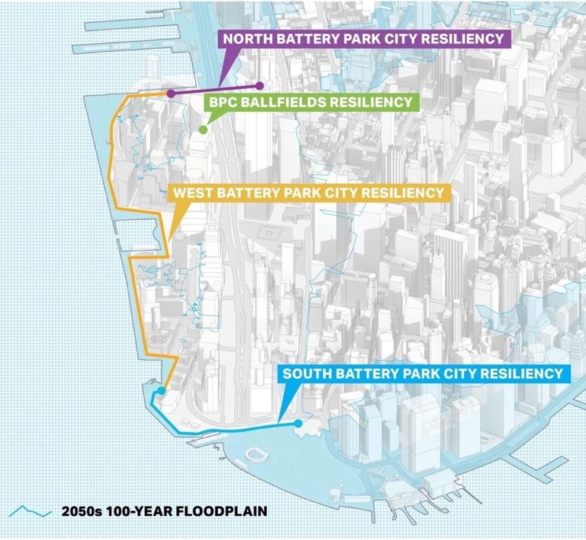
Wagner Park Pavilion Service Entrances

                                         7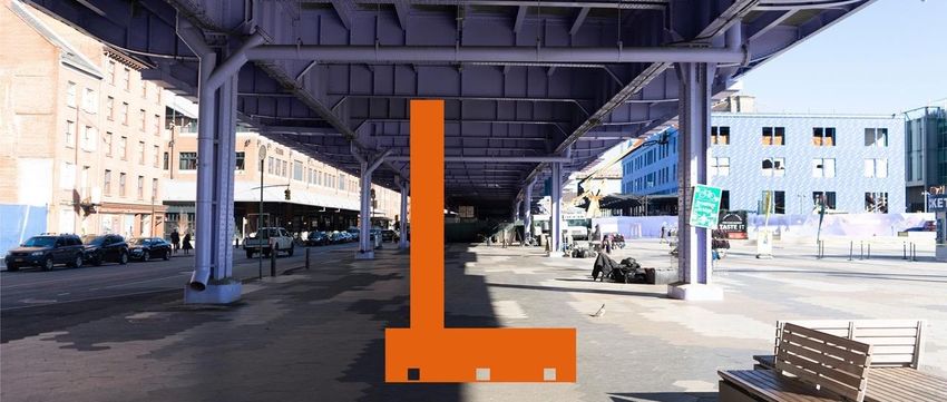
BATTERY PLACE DESIGN– Presented to CB 1 February 2021

                                                                                                    SIGN T YPE B1
     SIGN T YPE B1                                                                  PY LON WAYFINDING WIT H MAP
                                                      STREET TREES
     PY LON WAYFINDING WI T H MAP
                                                                               AL L EE RAMP SHORTENED
                RAMP ADDED FOR DIRECT ACCESS
                T O WAGNER PARK

                           S E ATING AT BU S S T OP                  AL L EE TERMINATION P U L L S IN
                                                                     FOR ENT RY T O WAGNER PARK

                                                                                                                    8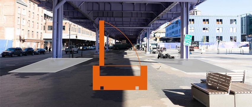
BATTERY PLACE DESIGN– Presented to CB 1 – February 2021
                         SIGNAGE (TBD                 ADJUSTABLE                              STAINLESS STEEL WIRE   ADJUSTABLE             SIGNAGE (TBD
                         WITH CONSULTANT)             LIGHT FIXTURE                           MESH GUARDRAIL         LIGHT FIXTURE          WITH CONSULTANT)

    FLUSH STONE
    AND PAINTED
    STEEL FACADE
    SYSTEMS

                   CONNECTION FOR           KITCHEN SERVICE           REMOVABLE PLANTER   PARKS
                                                                                           BPCA MAINTENANCE                       PARKS
                                                                                                                                   BPCA         CONNECTION FOR
                   FLOOD PROTECTION                                   TO SEPARATE USES                                                          FLOOD PROTECTION
                   SYSTEM                      ENTRANCE                                        GARAGE                            ENTRANCE       SYSTEM

                                                                                                                                                                   9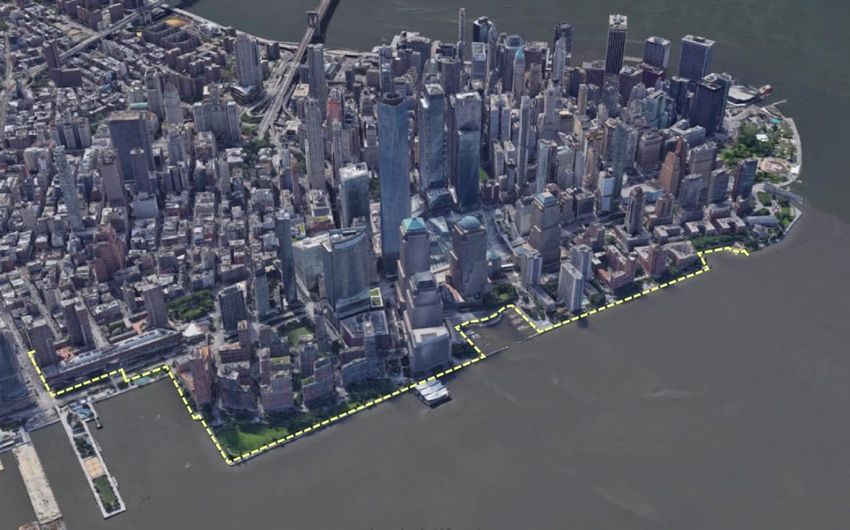
BATTERY PLACE DESIGN– Presented to CB 1 – February 2021
                                    SIGNAGE (TBD                 ADJUSTABLE                                  STAINLESS STEEL WIRE     ADJUSTABLE             SIGNAGE (TBD
                                    WITH CONSULTANT)             LIGHT FIXTURE                               MESH GUARDRAIL           LIGHT FIXTURE          WITH CONSULTANT)

    FLUSH STONE
    AND PAINTED
    STEEL FACADE
    SYSTEMS

                              CONNECTION FOR           KITCHEN SERVICE           REMOVABLE PLANTER     PARKS
                                                                                                        BPCA MAINTENANCE                           PARKS
                                                                                                                                                    BPCA         CONNECTION FOR
                              FLOOD PROTECTION                                   TO SEPARATE USES                                                                FLOOD PROTECTION
                              SYSTEM                      ENTRANCE                                          GARAGE                                ENTRANCE       SYSTEM

                   JET MIST                RAL 7011                 DEPLOYABLE                ADJUSTABLE            STAINLESS STEEL           TOURNESOL RECTANGULAR PLANTERS
                   GRANITE            PAINTED                   FLOOD                       LIGHT FIXTURES         WIRE DOOR PULLS

                                   STEEL WITH                            PROTE
                                   SIGNAGE (TBD)                         CTION                                                                                                      10
                                                                         SYSTE
                                                                         M
BATTERY PLACE DESIGN REFINEMENT– New Design Approach
11\
Parks
Parks
Service "
Service
\\ Entrance
Entrance\
\I \
/Restaurant
\ Restaurant
ServiceService
- Entrance
I' Entrance
\\ \
\
\
1213
14
1%                                                                                         1%

                                                                                                                                                                     2'-0"
                                                                          3'-0"
                                   +8'-3" AFF                                                                                 +8'-3" AFF

                           +7'-3" AFF                                                                                 +7'-3" AFF
                   2'-0"

                                                                                  10'-3"

                                                                                                                                                                             10'-3"
                                                                                                                                                                     8'-3"
                                                                          7'-3"
1% Min
                                                  03      18                               1% Min
                                                                                                                                             03      18
                + 10'-6"                                                                                   + 10'-6"

         R-20                                                                                       R-20
           11                                    R-20          42                                     11                                    R-20          42

                                           Refer to Structural Drawings                                                               Refer to Structural Drawings
                                           and Specifications for                                                                     and Specifications for
                                           Foundation Design                                                                          Foundation Design
                                                                                                                                                                                      15
NOTES:
1.ALL DOORS HAVE FLUSH SMOOTH EXTERIOR PAINTED FACES. REFER
TO FINISH COLOR.
2.VEHICLE DOORS ARE ON PIVOT HINGES WITH AUTOMATIC
SEALS. REFER TO DETAILS.
3.PERSONNEL DOORS ARE SUPPLIED WITH PANIC DEVICES ON THE
INTERIOR AND PAINTED PULLS ON THE EXTERIOR. REFER TO PULL
IMAGE.
1
3 Parks
Service
Entrance
2
Sidewalk Battery Place
1
3
Restaurant
1 Service
3 Entrance
16Birdproof Glass
Arnold Ornilux Coating (Sample Provided)
Pigmented Architectural Concrete Painted Metal Doors and Windows Painted Stainless Steel W ire Door Pulls
RAL 030 40 30
Exterior
Park Level 17Guardrail Precedent
18Guardrail Precedent
19C
L Post C
L Post Wall C
L Post
1'-4 5/8"
T.O. Rail
T.O. Rail
4 5/8" TYP 22
3"
5/8"
4" CLEAR 5/8" TYP 5/8" TYP
22
3'-6"
3'-6"
Low Point- Pavers
Low Point- Pavers
48 29 30 40
1% 1%
+20'-9"
6"
48
1'-2"
T.O. Curb
Elevation Detail 03
3" = 1'-0"
3"
Drain
30 48
T.O. Slab
5 7/8"
29
1 5/8"
L Post
C
1'-4 5/8"
+8'-3" AFF
48 22
EO Wall
4 5/8" TYP
C
L Post C
L Post
Plan Detail 02 Section Detail 01
20
3" = 1'-0" 3" = 1'-0"BATTERY WHARF
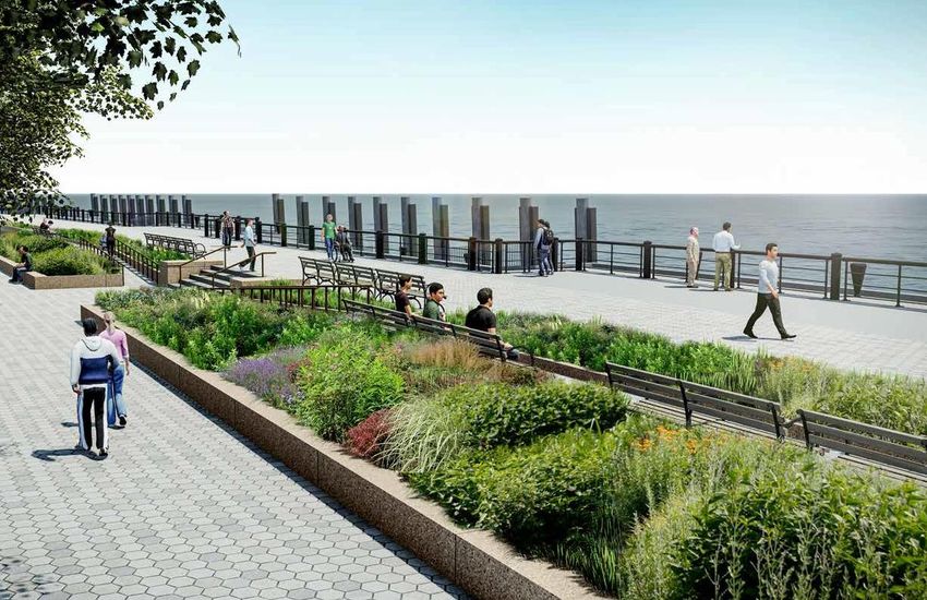
21The Battery Coastal Resiliency
Conceptual Rendering
EDC managing on Parks behalf
Public Meetings and Stakeholder Input Coordination
▪ March 24 – Open House
▪ BPCA coordination ongoing for Pier A tie-in
▪ PDC conceptual review ongoing
▪ NYPD, FDNY, OEM, Statue Cruises, NPS upcoming
Design Progress
▪ Preliminary Design - early Summer 2021
22FIDI-SEAPORT MASTER PLAN
23What have we been up to since we last met?
Met with the Aquatic Resources Advisory Committee (ARAC) to discuss why entirely on
land strategies do not work here and the need to go into the river, and received feedback on
there not being a viable permitting pathway for a maximum shoreline extension
Completed fall and winter aquatic habitat sampling to better understand the ecological
conditions of the East River; spring is ongoing
Completed our hydrodynamic and wave modeling to understand the height of future storms,
including waves, in our study area to determine the height of coastal protection that will be
needed
Hosted a virtual open house, a workshop on Envisioning a 21st Waterfront, a panel
discussion on Financing Resiliency Projects in Lower Manhattan, and visited 5th graders at
the Peck Slip School and high school students at the Harbor School
Developed early project concepts based on feedback from the regulatory agencies on the
need to justify every inch of fill, as well as community feedback on open space in the study
24
area, connections to the waterfront, and what they value the mostWhat we've heard through our engagement events and key themes that have
emerged
Process
Design Financing & Development
▪ Ensure transparency, so the community • Celebrate the historical identity of
this area • Resilience should drive project
feels like true partners with the City in this
options, not development
process • Increase the open space in this
area, with a variety of uses • Project financing should be equitable
▪ Bring in youth perspectives in our
engagement process
• Examine taking down the FDR • Limit development, and be mindful of
• Connect New Yorkers to the neighborhood contexts for where
▪ Exhaust all on-land options before looking waterfront, and make sure they development could be sited
at going out into the water can still get down and touch the
water
▪ Provide regular updates and share
• Ensure equitable access to
decision-making materials maritime assets, maintain the
navigability of the pier
25Sharing Decision-Making Materials
•Response to letter from CB1, CB3, Waterfront Alliance, Rebuild by Design
•Seaport City Study and RFP Scope (for study that concluded in 2014)
•LMCR Study and RFP Scope (for study that concluded in 2019)
•FiDi-Seaport RFQ (for current study 2019-2021)
•FiDi-Seaport RFP Scope (for current study 2019-2021)
•FiDi-Seaport On-Land Memo (produced by Arcadis under current contract after
we added this to the scope)
26Articulating our priorities: Developing a coastal defense project that is
permittable & implementable while also achieving key community
goals
Provide two levels of flood
protection - for both coastal storms
Replace existing and daily tidal flooding Plan for new resilient ferry
waterfront public and open terminals and facilities, with
space amenities that would long term adaptability in mind
be disrupted
Site Coastal Resilience
Infrastructure
Ensure universal access Protect our historic
to the waterfront, including and cultural assets
ferries and historic assets Site new drainage infrastructure
to ensure the entire flood
defense system works
Implementable: Permitting Considerations + Construction Feasibility
27Our early project options looked at three shoreline extension lengths; based on
technical analysis and feedback, we are now zeroing in on a narrow to
moderate option Narrow to moderate
extension Maximum shoreline
Entirely On-land This option has the clearest extension
This option avoids extending pathway for implementation based Federal and State regulators
the shoreline into the East on on-land constraints and regulatory have provided feedback that a
River but is not feasible due feedback, while allowing us to maximum shoreline extension is
to on-land constraints. achieve project goals. The middle not feasible due to the extent of
option width will vary throughout the impacts to the East River.
project area.
28Why is an on-land option so
challenging?The project’s design flood elevation (DFE) must protect from up to 20-25 feet of
flooding from the outset, and/or be designed to adapt in the future.
+11.0 ft Constant (Passive) Target
Elevation for Tidal Flooding
30What on-land coastal defense strategies have we looked at?
Based on technical analysis, a floodwall is considered the most viable coastal defense structure
for our target design flood elevation (DFE), or level of protection, of approximately +23 feet
(NAVD88).
Floodwall Building-Level Approaches
A floodwall is the most viable coastal defense option, but Relying on building-level approaches to provide area-wide
requires a significant amount of horizontal, vertical, and flood protection is not practicable given a high DFE, wave
underground space which is not available on land. loads and forces, and reliance on deployables to maintain
street and building access.
Street Raising Deployable Measures
Deployable measures are particularly challenging in our
Most street raising projects aim to improve drainage and
study area given the low-lying ground elevation and the tall
adapt to rising sea level, not coastal defense. In addition,
wave heights.
significantly raising street grades presents unsafe traffic
and pedestrian conditions and may require the
abandonment of lower-level floors.
31
31What makes an on-land floodwall so challenging in our project area?
1. Requires substantial vertical space to reach our DFE of +23 feet,
which is limited by the height of the FDR Drive for most of our study
area
2. Requires substantial horizontal space to construct and access for
maintenance, which is limited by the dense urban environment
Floodwall
3. A floodwall has a large foundation which requires the area below it to
be clear of any underground obstructions. However, our project
Foundation Width: 10-15 ft
area has a complex network of underground infrastructure Construction Clearance: 18-20 ft
Access Requirements: 15 ft
4. In order to provide a passive level of flood protection (not relying on (each side)
gates) for frequent tidal flooding in 2100, we need to elevate the
ground elevation at the waterfront to 11 feet (NAVD88). However, this Total Footprint: ~45 feet
grade change will have to be gradual in order to maintain universal
waterfront access, requiring even more horizontal space to
implement
32
32Why is an on-land option so challenging?
Limited available space along
the waterfront requires us to
also look at what we can do
beneath the FDR Drive shown
in blue. However, there is
insufficient vertical and
horizontal space under the
There is limited unobstructed FDR Drive to fit coastal
space above ground to fit defense infrastructure.
coastal defense infrastructure
in the study area, with the only
available space (0-40’) shown
in pink. This is not enough The FDR isConnections
not at one to
space to provide protection for elevation, butBrooklyn
changes fromand
Bridge a
the whole project area, and it subsurface roadway to at-
FDR Drive
severely restricts our options. grade to an elevated structure
all within the study area.
Bulkhead Line
(Existing Edge) 33Why can’t we put a floodwall under the FDR Drive?
State DOT requires a vertical clearance of 5 feet from the FDR viaduct. The height of a floodwall needed to
achieve our DFE would exceed the maximum allowable height under the FDR.
FDR VIADUCT
16.5 FT ABOVE GRADE
HEIGHT OF FLOODWALL
TO ACHIEVE DFE
14 FT TALL
MAXIMUM ALLOWABLE
HEIGHT
11.5 FT TALL
34If we modify the FDR Drive, can we achieve our flood protection without going
into the water?
• We looked at options to bury the FDR, which X
were deemed infeasible
• A trough (like the Battery Park Underpass)
would interfere with the subway tunnels and
underground infrastructure
• A tunnel (like the Hugh Carey Tunnel)
would have to go into the water and would Trough
be extremely expensive
• Both options are extremely costly, technically
X
challenging, and very difficult to implement
Tunnel
35If we modify the FDR Drive, can we achieve our flood protection without going
into the water?
• Through studying these different options for the FDR Drive, we’ve learned that replacing the
FDR with an at-grade roadway still does not provide enough space to site flood protection
on-land and avoid going into the river.
We still do not have enough space to achieve our constant level of flood protection
on-land while maintaining access to the waterfront
To achieve our waterfront access goals, we would be solely reliant on deployable
measures to achieve our target level of flood protection, which is not recommended
due to the study area’s location relative to the New York Harbor and wave action
Still requires extensive ramping to get back down to the water
We would be impacting the current waterfront programming, with limited space to
replace what is currently there today
Does not allow for future adaptability of the flood protection system
36Why won’t relying on building-level approaches work?
1. Most buildings along the water are not designed to withstand the wave loads and forces associated with
storm surge, requiring an independent structure to still be constructed.
2. This would impact access to and from buildings, requiring many deployable measures, such as gates, to
maintain existing connections between the street, sidewalk, and buildings. With future daily tidal flooding,
this will not be practicable.
3. Building-level approaches would also create a dependence on private property owners to provide critical
flood protection across the area.
Source: NYC DCP
Building-level approaches may involve a combination of Height of needed building-level flood protection to
floodproofing and relocating critical systems, possibly abandoning reach our DFE (South Street) 37
the basementWhy won’t raised streets work to provide area-wide protection?
1. Requires independent flood protection
Coney Island, NY
structure with foundation integrated into - Streets raised at most 6.5
roadway, particularly challenging for FiDi feet to redirect
stormwater on peninsula
2. Significant impact to existing street grid - Little existing
and connections, surface drainage, and development around
underground infrastructure (incl. cover) streets raised
- No adaptation of existing
3. Limited applicability: context to street grade
Only recommended where existing street is
within 4 feet of the DFE Ocean City, NJ
- Streets raised (on
Would still require relocation of underground average) 4.5 feet to
infrastructure and new access points (manholes improve drainage and
etc.) raise Route 40
- Includes pump stations
38What about deployable measures?
▪ In some areas we still need to use deployable measures to maintain access across the study area.
However, given the wave forces in the area, passive measures, such as levees and floodwalls, are preferred.
▪ Because the area is low-lying, deployable measures must be used in conjunction with raising the edge
▪ Deployable measures, such as stop log systems or flip-up gates, are designed to withstand greater wave
forces than measures that can be deployed just ahead of a storm. These are different from “just-in-time”
measures, such as Tiger Dams, which are not a long-term solution
▪ These types of deployable measures still require adequate vertical, horizontal, and underground space to
accommodate foundation requirements and on-site storage
Flip-Up Gate Stop Log / Plank System Roller Gates
Source: PS Flood Barriers Source: 140 West Street Source: PS Flood Barriers
39Why can’t we put a deployable flip-up gate under the FDR Drive?
The FDR columns have wide foundations, from which a horizontal clearance of 5 feet is required. This does
not leave enough horizonal space to construct a flip-up gate that would flip up to the height required to achieve
our DFE.
HEIGHT NEEDED TO
ACHIEVE DFE
14 FT TALL MAXIMUM HEIGHT
OF FLIP-UP GATE
10 FT TALL
FDR FOUNDATION WIDTH FDR FOUNDATION WIDTH
+ 5 FT CLEARANCE + 5 FT CLEARANCE
AVAILABLE HORIZONTAL SPACE
13 FT
40How does needed drainage infrastructure add to these challenges?
▪ New large-scale drainage infrastructure will be
required for our costal defense system to work and
to ensure that the existing drainage system
provides the same level of service under future sea
level rise
▪ To ensure rainwater does not “pond” or collect
behind the coastal defense, a combination of
pumping and storage solutions are being
considered Pump Station in Hoboken, NJ
Source: NJ.com
▪ At a minimum, this would require a pump station
with necessary pipelines, which would collect and
pump rainwater into the East River during wet
weather events. This could take up to 13,000
square feet both above and below ground
Manhattan Pump Station
41To recap why an entirely on-land project is infeasible…
1. We cannot site an entirely on-land project that protects against daily tidal flooding and coastal storms while
maintaining public waterfront access and maritime uses.
2. There is very limited available space along the waterfront. In addition, there is not enough vertical space
beneath the FDR Drive to construct our floodwall, nor is there enough horizontal space to fit a flip-up gate.
3. Some options to modify the FDR Drive are infeasible and overly expensive, while others would not generate
enough additional space for a floodwall that maintains waterfront access.
4. Neither building-level solutions or street raising are viable alternatives for most of our project area.
5. While deployable measures have a lot of utility and may play a role in any coastal defense solution, we
cannot solely rely on them to provide the level of protection required across the whole project area.
6. A complex network of underground infrastructure resides beneath the streets and can’t be easily moved.
Constructing our foundations for the coastal defense must carefully consider the performance of each
element to ensure our drainage infrastructure, transportation network, and utilities continue to function.
7. New drainage infrastructure is necessary for our coastal defense to work and will require a substantial
additional amount of above-ground and underground space.
42How have we been approaching
the design of the project?
43How do we build our coastal defense without walling off the city?
• While constructing a wall along the
existing bulkhead line would
provide constant flood protection
for Lower Manhattan, it would not
meet other project goals, including:
• Provide the necessary space
needed to site new drainage
infrastructure
• Maintain key connections
between the upland
neighborhood and the
waterfront for key maritime
functions & water-borne
transportation
• In addition, a wall at the water’s
edge would create an unsafe
condition beneath the FDR Drive,
with poorly lit corridors and
unhealthy air quality
44Why is a solution that relies predominantly on gates not applicable here?
• FiDi Seaport has larger waves
compared to neighboring projects
due to its location relative to the NY
Harbor. Larger waves, as well as
lower ground elevations make Some extension would be necessary to
deployable measures – like gates meet passive flood protection goals
– less suitable for our project area.
• In addition, the area is vulnerable to
future daily tidal flooding;
therefore, we need to design to a
constant “passive” level of flood
protection that is always there
• As a result, gates must be used
sparingly and in concert with
passive measures to ensure a
reliable, operable, and maintainable
coastal defense system
45In order to achieve the project’s goals, we are proposing to extend the shoreline
of Lower Manhattan
• While siting the coastal defense, we
need to maintain universal access
to the water - meaning that
everyone, regardless of ability or
age, can access and participate in Extension is driven by need to
public life get up to the line of defense…
• Space is needed to allow for the
appropriate slopes and grade
changes to ensure access for all
getting up and over the design flood
elevation
• Space is also needed to provide
emergency and maintenance
access (vehicular) to the flood
defense, maritime uses, & water
• Within this space there are also
opportunities to site drainage
infrastructure, capture stormwater
run-off, and replace existing open
space 46This includes a multilevel waterfront to meet site access needs, as well as
space to connect to maritime uses and a publicly accessible waterfront
• We also need to accommodate
universal access from the
neighborhood back down from the
design flood elevation to the water’s
edge
… and back down
• At the water’s edge, we need to:
to the water
• Plan for adaptive maritime
uses, acknowledging their
unique functions as well as
vulnerability to sea level rise
and storms
• Provide a continuous
waterfront esplanade in
keeping with the East River
Esplanade plan, with access to
these maritime functions
47Our design must get people up to and down from our flood protection,
providing three distinct zones for us to design.
Design conditions will
vary along the
waterfront
Some elements are less flexible as
they are informed by engineering,
policy, and regulatory
considerations.
Draft: Early illustration of
flood defense system. Other elements offer more flexibility
Subject to refinement.
to collectively reimagine the
waterfront.
Zone 1 Zone 2 Zone 3
Transportation Corridor Publicly Accessible Continuous
Flood Protection Zone Waterfront
Access & 48
Maritime ZoneHow can we provide universal access at frequent access points in line
with the East River Esplanade vision?
• A switchback allows a user to
arrive at a similar point along
the waterfront that they
entered, as well as flexibility in
connecting multiple access
paths across the site
• Slopes that are not too steep
ensure we can maintain
plantings while also the ability
to capture stormwater runoff
• A 16’ wide path provides
enough space for users to
access the waterfront, as well
as sufficient space for vehicles
to access the site for
Case 1: 16’ Change Case 2: 20’ Change
operations & maintenance (2) Access paths @16’ ea = 32’ (2) Access paths @16’ ea = 32’
16’ vertical at 33% slope = 48’ 20’ vertical at 33% slope = 60’
80’+ Contingency 92’+ Contingency
49
Note: this configuration is not a specific design, it is a basis for estimating space needs for accessPublic Access & Program
Getting up to the flood protection
"Public park space that is open, available,
accessible with a variety of different
Where is there flexibility for community feedback to guide the project options? programs that address many groups'
• How do we better connect the community with the waterfront? needs"
• How should we get up to the design flood elevation from the city?
• What different programs and amenities would you like to see here? (plazas/lawns, playgrounds, active
programming, dog parks, cultural facilities, etc.)
• What role do structures / buildings play in shaping the waterfront?
Recreational Space 50
50Waterfront & Maritime Access
Getting back to the water, maritime uses, and a continuous waterfront esplanade along the East River
Where will we co-create?
• What should the experience of
the East River esplanade be?
• Looking at other examples from
around NYC, what design
elements would you most like to
see along a waterfront
esplanade?
• How should we treat walls
along the waterfront
esplanade?
• What kinds of programs and
opportunities should we
prioritize at the water’s edge?
Note: this configuration is not a specific design, it is a basis for estimating
space needs for access
51Public Engagement Approach
Empowering stakeholders by advancing understanding of the science of climate risks and the technical constraints
and tradeoffs of building flood protection in the study area.
• Create opportunities for co-creation to develop project options that meet the needs and priorities of local and regional
stakeholders.
• Delegate power to planning partners to expand engagement and bring more people into the conversation.
• Actively consult with individuals and organizations with a stake in the project and incorporate feedback into the project
development
• Coordinate closely across City, State, and Federal Agencies to ensure alternatives advanced are feasible and implementable.
Upcoming public Check us out at
meeting June 28 th
fidiseaportclimate.nyc
and 30th
Host meetings
Develop an
Host online public Create a new across a broad
extensive marketing
forums interactive portal array of
Strategy strategy
stakeholders
&
Hold ongoing Host smaller,
Tools meetings with subject-specific
Work with
educators in
Utilize social media
CCLM, Regulators, meetings and platforms
creating curriculum
electeds workshops
Met with students at
Held three workshops Peck Slip School, 52
from January - April Harbor School 52LMCR UPCOMING ENGAGEMENT
53Upcoming LMCR Public Engagement
Timeline
Projects
June July August Fall
CB 1 EP Update (6/21)
Battery Park City South Project Scoping Meeting
Battery Park City North/ CB 1 EP Update (6/21)
Project Kickoff
West
CB 1 EP Update (6/21)
The Battery Public Meeting #2
CCLM 5 (6/16)
Open House #3 (June 28,
FiDi-Seaport 30th)
CB1 EP Update (6/21)
Procurement Process
BMCR
Updates (DDC)
CB 1 EP Update (6/21)
Overall LMCR Strategy
Quarterly Update Call
54You can also read