ENGINEERING DIVISION Capital Improvements Section - City of Flagstaff
←
→
Page content transcription
If your browser does not render page correctly, please read the page content below
ENGINEERING DIVISION
              Capital Improvements Section

            Monthly Capital Projects Report
                    January 2022

Honorable Mayor, Vice Mayor and Council,

The January report was completed by our Project Managers on January
14th and includes project updates for the month of December and
some January activity.

The attached map is a comprehensive view of all active capital
improvements projects in our community that are assigned to the
Capital Improvements Section of the Engineering Division, inclusive of
projects that are in planning, design, and construction phases.

We have tried to reduce the extent of information provided and
focused on only those projects that had substantive progress from
previous months or have key milestones to share.

If you would like to receive more information on a specific project,
please reach out and we’d be glad to share more detailed information.

                                 -1-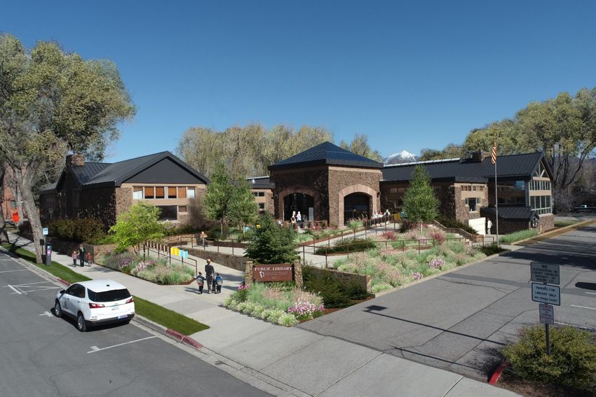
Active Transportation Master Plan
On September 13, 2021, the City released the draft Active
Transportation Master Plan (ATMP) for a 60-day public
comment period. The ATMP will serve as a guide to
enhancing walking and biking in Flagstaff. The draft
document includes detailed information regarding pedestrian
and bicycle accommodation and establishes a series of goals,
policies, and strategies to support walking and biking.

•   The community survey was extended to December 19,
    2021 to allow additional public comment. Follow this link
    to access the survey. To date, almost 250 responses have
    been received. Staff will begin compiling results as soon
    as the survey closes.
•   Staff has made presentation to a variety of City
    commissions:
    Diversity Awareness
    Inclusion and Adaptive Living
    Open Spaces
    Parks and Recreation
    Planning and Zoning
    Sustainability
    Tourism
    Transportation
•   A series of five community open houses were conducted during the 60-day public review period to inform the
    public, discuss the contents of the plan and provide opportunity for community questions and feedback:
    Wednesday, September 29, 2021 | 6:00 - 7:00 p.m.
    Thursday, October 7, 2021 | 6:30 - 7:30 p.m.
    Saturday, October 16, 2021 | 10:00 a.m. - 12:00 noon @ Bushmaster Park
    Tuesday, October 19, 2021 | 12:00 noon - 1:00 p.m.
    Wednesday, October 27, 2021 | 5:30 - 6:30 p.m.
•   Rick Barrett and Martin Ince of the Engineering Division were interviewed by Peter Bruce on KAFF radio on Tuesday,
    October 5, 2021.
•   Staff continues to refine the 20-year program of pedestrian and bicycle projects that will be funded with the
    pedestrian/bicycle portion of the transportation sales tax and Mountain Line’s first/last mile grant. An interactive
    map of planned sidewalks, bikeway, FUTS trails, enhanced crossings, and grade-separated crossings is available at
    this link.
•   The ATMP will be accompanied by a minor amendment to the Regional Plan to incorporate infrastructure maps from
    the ATMP and some of its general language. A draft of the minor Regional Plan amendment can be viewed here.
•   The final process for review and approval is scheduled for early-2022. Final Council approval is anticipated in March
    of 2022.
•   The draft ATMP can be downloaded here. For more information, go to the ATMP webpage.

                                                          -2-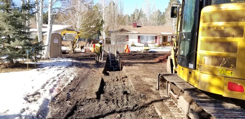
Woody Way
A citizen petition was submitted to Council for discussion on September 23, 2021 to make Woody Way a one-way street
westbound, while still allowing for emergency vehicular access. Staff gave a presentation to Council explaining
background of the Woody Way Gate and touched on some of the data that has been, and will be, collected. Since this
issue has already been in the hands of the Transportation Commission, Council decided to not allow the FAIR item to
move forward and to let the Commission make a recommendation to Council on a decision for the connector roadway.

Project Update:
        • The Transportation Commission met on December 1st to review origin and destination traveler information
           for people that are utilizing Woody Way on a daily basis. The trend is that most people utilizing Woody Way
           start their trips in Presidio and end up East of Boulder Pointe in the morning and most trips in the afternoon
           start their trips in the City East of Boulder Pointe and end up in Presidio. A much smaller percentage of trips
           originate or end in Boulder Pointe and an even smaller percentage of trips are ‘cut-through’ which is not
           having an origin or destination in either neighborhood. The Commission also reviewed some additional
           calming measures surrounding the Axe Handle and Woody Way intersections.
        • City Council met on December 14th to discuss the Traffic Commission’s Recommendation and supported
           moving forward with additional traffic calming measures as proposed to keep the interconnectivity
           between neighborhoods open to the public.

                                  Woody Way, looking west from Boulder Pointe to Presidio

                                                           -3-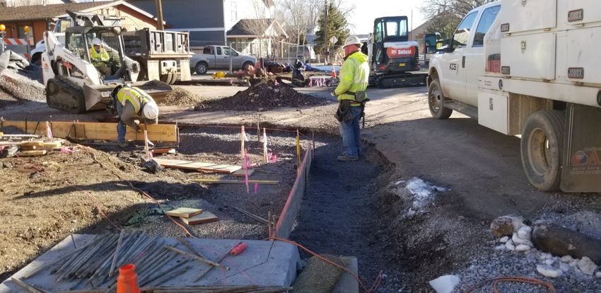
Boulder Pointe – University Avenue Traffic Calming
Through the removal of the Woody Way gate that once separated the neighborhoods of Presidio and Boulder Pointe,
staff discovered that speeds on University are high enough to warrant traffic calming measures. We have presented to
the Transportation Commission concepts for traffic calming and invited the public and HOA’s for input. The outcome
was to install temporary center island medians and a bump out using candlesticks, along with a radar feedback sign at
each end of the straightaway on University. Public Works installed the temp traffic control along University in June
2021. Traffic counts have been collected to see if the temp traffic calming measure have worked and the 85th percentile
speed has decreased by 2 mph in both locations on University.
    • Transportation Commission reviewed modifications to the University at Tombaugh temporary traffic calming
         setup at their December 1 meeting. The commission heard public comment and recommended staff move
         forward with a new design utilizing curb extensions and a neighborhood mini circle. This new temporary setup
         will replace the existing center island narrowing setup when weather permits.

                                                          -4-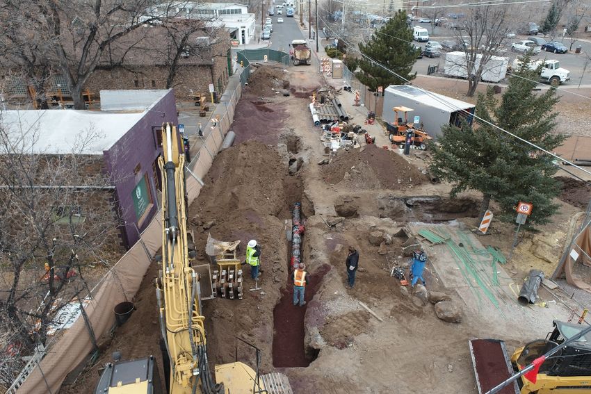
-5-
Protected Bike Lane Pilot Projects (Butler Avenue & Beaver Street) (DESIGN & CONSTRUCTION PHASE)
FUND: TRANSPORTATION TAX (BICYCLE AND PEDESTRIAN PROJECTS)
Description – At Council’s July 6, 2021 meeting, staff was directed to pursue two pilot projects intended to enhance the
safety and overall experience of the community’s cyclists in our downtown area. Depicted in the map below, Council
directed staff to move forward with the concrete & candlestick treatment on both pilot projects with a target
completion by December 30, 2021. The Butler Ave pilot project’s scope consists of the approved treatment and some
additional striping between Milton Rd. and Sawmill Rd., approximately 0.9 miles. The Beaver St. pilot project’s scope
consists of the approved treatment, some lane obliteration and restriping, where applicable between Forest Ave. and
Butler Ave., approximately 1.2 miles.

        Project Update:
            • The contractor completed the installation of the curb and candlesticks for both Phase I and II on
                November 19,2021 .
            • A walk through of Phase I and II was completed on December 10,2021. The pilot program was found to
                meet the intent of the initital scope. A final letter of acceptance has been issued.
            • Job Order Contracting Contractor, Eagle Mountain Construciton, Inc. successfully completed the project
                and the City of Flagstaff is extremely happy with their delivery of the project.
            • As these are pilot projects, staff is taking the winter and the upcoming Spring months to collect data and
                observe the fucntional and maintenance impacts of this new infrastructure in the City’s network.

                                                        Beaver Ave., looking south, just south of Forest Ave.

                                                          -6-
Museum Fire Flood Mitigation/Division D (DESIGN & CONSTRUCTION PHASE)
FUND: STORMWATER

Description: The Engineering Division is providing support to Water Services’ Stormwater Section and to Coconino
County’s Flood Control District for emergency operations and flooding associated with the 2021 Monsoon Season.

   Project Update:
           • Emergency Channel Widening Project at end of Paradise Road.
                   o Construction began in mid-September and was completed in mid-November.
           • Providing Stormwater Section support including overflow flood mitigation, debris/sediment clean-up and
              development of a flood gate detail for use on properties that have perimeter sandbags to allow driveway
              access when flooding is not occurring.
           • Working to identify property acquisition needs along E. Appalachian Drive, E. Skyline Drive, E. Hemberg
              Drive, E. Matterhorn Drive and N. St. Moritz Way.
           • Kinder Morgan has tentatively agreed to allow city to use 6½ acres on the pipeline for
              sedimentation/detention purposes.

                     Pre-Construction Image of Channel Widening Project at North End of Paradise Road.

                         Image Taken on 10 November; after Channel Widening Project Completion.

                                                           -7-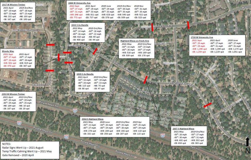
Spruce Wash – Cedar to Dortha and Dortha Inlet (Design Phase)
FUND: STORMWATER

Description - Design consists of improvements to the Spruce Wash Channel from Cedar Avenue to south of Dortha
Avenue. This work is in response to the damage that occurred during the 2021 monsoon flooding from the Museum Fire
burn scar.

       •   On December 7, Council approved an ordinance authorizing the acquisition of drainage easements,
           temporary construction easements, and any other necessary property rights for drainage and flood control
           improvement for the project and included an emergency declaration.
       •   The new drainage easement exhibit was developed and approved. SWI, the design engineer, is working to
           complete individual legal descriptions for property acquisition. These are due December 17. Three
           appraisers have been selected and are ready to perform the property appraisals and begin the acquisition
           process.
       •   City staff has begun to reach out to the affected property owners to meet and discuss construction of the
           project, acquisition, and obtaining early right-of-entry approvals to expedite construction.
       •   The team has been coordinating with the franchise utility companies to discuss required relocations.
           Findings on relocation impacts have been favorable overall and we are working to expedite them after the
           first of the year.
       •   Tiffany, our JOC contractor, is engaged in providing assistance and recommendations on cost, final design,
           utility relocations, and plans for expedited construction.
       •   Completion of the improvements will occur prior to monsoons 2022 (June 15).

                                          Spruce Wash north of Dortha Avenue
                                                         -8-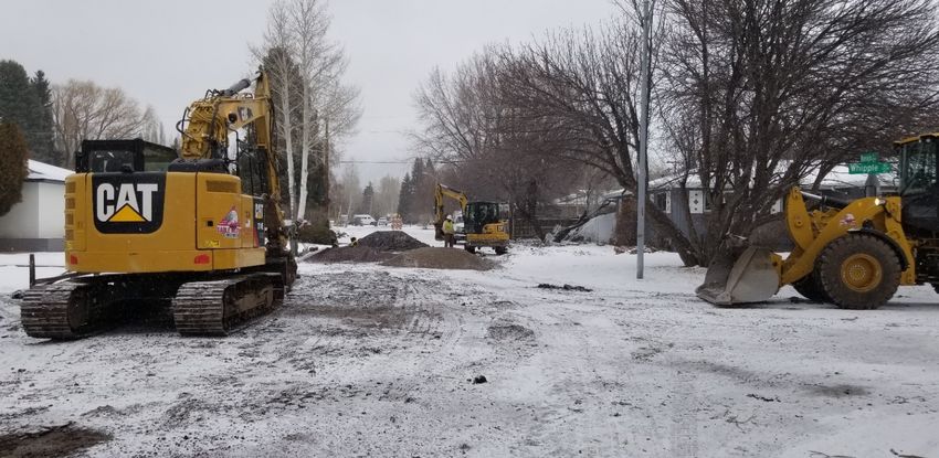
Spruce Wash – looking south at Dortha Avenue

                   -9-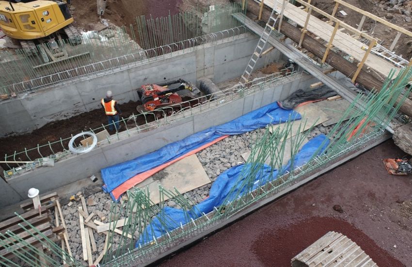
Spruce Wash – Park Basins (Design Phase)
FUND: NRCS GRANT/STORMWATER

Description – This project adds four sediment basins and five rock vein weirs below the recently-completed Spruce
Wash Channel Widening Project (northern end of Paradise Road) and upstream of Linda Vista Drive. These basins will be
part of a sediment deposition system for flood waters from the Museum Fire burn shed before conveyance to the
Sunnyside neighborhood.

       •   City will acquire property rights to support the County Flood Control District (CFCD) project management
           and is working on property classifications and evaluating drainage easements within the project extent.
       •   National Resource Conservation Services (NRCS) grant is not able to fund property acquisition so City
           Stormwater funding will be used for this purpose.
       •   City will keep the park designation for the city parcel and is considering development of a trailhead for
           Forest Service access that respects the Beal Wagon Road historical alignment in the area.
       •   Natural Channel Design (NCD) will be completing the project design. Currently plans are at 15-percent.
       •   CFCD received funding of $3.5M for work out of the city and includes the Park Basins. The timeframe is 220
           days.

              NORTH
            Project Extent from 30% Plans. Paradise Road is on the Bottom; Linda Vista Drive is on the Right.

                                                         - 10 -
La Plaza Vieja Traffic Calming (CONSTRUCTION PHASE)
FUND: TRANSPORTATION TAX (SAFETY) & HOUSING [CDBG] ALLOCATION
Description – The project is assisting the neighborhood by improving pedestrian safety of crosswalks, sidewalks, bike
lanes and storm drainage at the Kingman Street and Florence Street/Malpais Lane intersections along Clay Avenue.
Contractor – Kinney Construction Services
Project Update:
• Concrete curb/gutter, sidewalk, and sidewalk ramps are complete on the south side of Kingman/Clay.
• The storm drain improvements are complete across Clay.
• The north catch basins were installed the week of 12/6/2021.
• The additional work of replacing the entire fire hydrant assembly on the north side of the Kingman/Clay
intersection was completed on 12/18/2021 due to the existing materials not meeting current
engineering standards.
• Installation of concrete curb/gutter, sidewalk, and sidewalk ramps on the north side of the
Kingman/Clay intersection continues as weather and site conditions allow.
• A Winter Shutdown was issued effective 12/17/2021, which KCS is choosing to continue work through to
complete curb, sidewalk, and temporary asphalt patch installations until weather and conditions allow
for the permanent asphalt removal and replacements.
• Kingman St. from Tombstone Ave. to Clay Ave. is closed to through traffic. The north half of Clay Ave. is
closed to all traffic between Globe St. and Malpais Ln. and the south half is a eastbound one-way travel
lane that allows traffic past the construction and pick up and drop off for the Haven Montessori School.
Detour routes are posted for west bound Clay Ave. closure starting at Malpais Ln. and the traveling
public is encouraged to seek an alternate route.
Kingman/Clay intersection looking east at curb and sidewalk prep work
.
- 11 -Beulah Boulevard Extension/University Drive Realignment (DESIGN PHASE)
FUND: TRANSPORTATION TAX (STREETS)
Description – This project extends the northern terminus of Beulah Boulevard to connect with University Drive.
Furthermore, University Avenue (west of Milton) will be realigned to match up with University Drive (east of Milton).
A new roundabout will be constructed where Beulah Boulevard and University Drive will intersect.
Project Update:
• Shephard-Wesnitzer, Inc. (SWI) is the design engineer.
• Eagle Mountain Construction (EMC) is the CMAR contractor for design phase services.
• 90% design plans are being reviewed by project stakeholders. The review will likely take approximately 4-
6 weeks and comments should be fully integrated by the end of February.
• Design work will continue to Final 1s (95%) and Final 2s (100%), which are the construction-ready
documents. Final 2s should be completed by May.
• Construction will likely be two phases over two construction seasons; starting in June/July 2022
concluding in July 2024.
Extent map of new Beulah and University Roadway Project – taken from 90% plans.
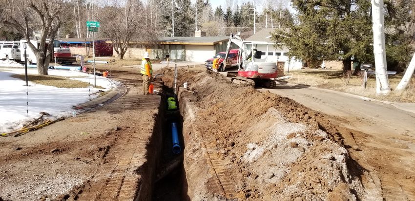
- 12 -Coconino Estates Improvements Phase II (CONSTRUCTION PHASE)
FUND: ROAD REPAIR & STREET SAFETY & AGING WATER AND SEWER INFRASTRUCTURE REPLACEMENT PROGRAMS
Description – This is a utility and roadway improvements project located on several streets in the Coconino Estates
neighborhood as seen in the map below. Improvements on the streets generally consist of replacing all existing utility
and roadway infrastructure. The utility improvements include replacing the existing water and sewer mains, water and
sewer services, fire hydrants, and manholes. The roadway improvements include replacing the existing asphalt roadway,
replacing rolled curb with vertical curb, constructing driveway ramps at driveway entrances, and replacing select
sidewalk only where it currently exists on Crescent Drive. Sidewalk will NOT be installed where it does not currently
exist. For additional information visit the Project website at www.coconinoestates.com
Contractor – Standard Construction Company
Project Update:
Crescent Drive and Meade Lane
• Sewer installations and temporary roadway trench patches are complete.
• Water installations and temporary roadway trench patches are complete on Meade, with testing and
public and private connections remaining.
• Water main installations and temporary patching roadway water trenches will continue and are
complete from Meade up to Talkington as of 1/13/2022, with testing and public and private connections
remaining.
• Water service installations will begin starting at Meade and work north.
• Crescent will be closed to through traffic from Meade to the Talkington/Louise intersection, with
detours posted around the closure for non-residential traffic.
Navajo Drive and Elizabeth Road
• Sewer installations and temporary roadway trench patches are complete.
• Water installations are anticipated to begin in February.
• The week of 12/27/2021 several sewer service trenches settled near the curb where the existing curb
was not removed causing holes to appear on both sides of the curb and small sections of the temporary
roadway trench patched to collapse. The areas were delineated and protected, and Standard
Construction Company was informed of the issue and addressed it immediately.
• Navajo will remain closed to through traffic with access maintained for residents on Navajo until water
installations begin.
- 13 -Crescent Dr. just north of Meade Ln., looking north at temporary patches over the new water main.
Crescent Dr. at Talkington corner, looking northwest at new water main construction.
.
- 14 -Coconino Estates Improvements Phase II Project Map
- 15 -West Flag Improvements - David & Hutcheson (CONSTRUCTION PHASE)
FUND: ROAD REPAIR & STREET SAFETY
Description – This is a utility and roadway improvements project located on David Drive and Hutcheson Drive as seen
in the map below. The Project originally included Canyon Terrace and was bid as one project in the spring of 2020 but
was pulled at the end of the bidding process given the economic and funding source uncertainties due to the COVID 19
Pandemic. It was decided to split the Project into two separate projects consisting of 1. David/Hutcheson and 2. Canyon
Terrace. Improvements on the streets generally consist of replacing all existing utility and roadway infrastructure. The
utility improvements include replacing the existing water and sewer mains (except for on David Drive), water and sewer
services, fire hydrants, and manholes. The roadway improvements include replacing the existing asphalt roadway,
replacing rolled curb with vertical curb on David Drive, and replacing select edge improvements (sidewalk, curb, and
gutter). For additional information visit the Project website at www.Flagstaff.az.gov/westflagimprovements.
Contractor – Mountain High Excavating
Project Update:
• Water main, water and sewer service installations are complete on David, except water connections.
• Storm drain improvements on David are complete.
• David roadway paving has been completed from William to 332 David, 40% of the Project.
• David roadway subgrade and subbase preparation in anticipation of roadway paving operations from
332 David to the north end of David will pause until weather and conditions allow for work to resume.
• Concrete curb, driveway, and sidewalk installations continue on David working north from William.
• Water and sewer main and service installations are complete on Hutcheson, with testing and water
connections remaining.
• Hutcheson gas service installations continue by Unisource, with completion anticipated in January.
• A Winter Shutdown was issued effective 12/17/2021, which MHE is choosing to continue work through.
• David and Hutcheson will be closed to thru traffic from William to Fine, with detours posted.
332 David Dr., looking north at
concrete curb, driveway, and
sidewalk installations.
- 16 -West Flag Improvements - Canyon Terrace (CONSTRUCTION PHASE)
FUND: ROAD REPAIR & STREET SAFETY
Description – This is a utility and roadway improvements project located Canyon Terrace Drive as seen in the map
below. The Project originally included David Drive and Hutcheson Drive and was bid as one project in the spring of 2020
but was pulled at the end of the bidding process given the economic and funding source uncertainties due to the COVID
19 Pandemic. It was decided to split the Project into two separate projects consisting of 1. David/Hutcheson and 2.
Canyon Terrace. Improvements on the streets generally consist of replacing all existing utility and roadway
infrastructure. The utility improvements include replacing the existing water and sewer mains, water and sewer
services, fire hydrants, and manholes. The roadway improvements include replacing the existing asphalt roadway and
select curb and gutter. For additional information visit the Project website at
www.Flagstaff.az.gov/westflagimprovements.
Contractor – Mountain High Excavating
Project Update:
• Water and sewer main and service installations are complete.
• Roadway paving is complete.
• Concrete driveway, curb, and valley gutter replacements were completed the week of 12/6/2021.
• Manhole and water valve adjustments within the roadway were completed the week of 12/6/2021.
• Private water service connections were completed the week of 12/6/2021.
• The final two water main tie-ins were completed the week of 12/13/2021.
• A Winter Shutdown was issued effective 12/17/2021, which MHE is choosing to continue work through.
• Landscape restorations will be completed as soon as weather and conditions allow and are anticipated
to be completed no later than early this spring.
• Work zones will vary during this final remaining work.
Canyon Terrace Dr, looking north
at paved roadway and adjusted
manholes and water valves
- 17 -Coconino Estates Improvements Phase I (CONSTRUCTION PHASE)
FUND: ROAD REPAIR & STREET SAFETY
Description – This is a utility and roadway improvements project located in the Coconino Estates neighborhood on Beal
Road from Rockridge to Fort Valley, Navajo Drive from Navajo Road to Murray, Whipple Road from Navajo Drive to
McMillan, and Navajo Road from Navajo Drive to Fort Valley. Improvements on the streets generally consist of replacing
existing infrastructure with new, including water and sewer mains, water and sewer services, fire hydrants, storm drains,
streetlights, the entire asphalt roadway, and defective select edge improvements (curb & gutter, sidewalk, etc.), except
for Whipple Road which will only receive a new water main. There will also be new infrastructure added consisting of
underground electric lines for streetlighting and sidewalk on both sides of the street where it does not currently existing
on Beal Road, Navajo Drive south of Beal, and on Navajo Road. For additional information visit the Project website at
www.coconinoestates.com.
Contractor – Eagle Mountain Construction
Project Update:
A new way of communicating project information has just been started with the recent installation of a new
project sign and banner prototype that include a QR code for the public to scan and view more information on
the Project website.
Navajo Road (Construction Zone #1)
• Utility, roadway, and landscape restorations are complete.
• Navajo Road is open to all traffic.
Navajo Drive south of Beal (Construction Zone #2)
• Utility, roadway, and landscape restorations are complete.
• Navajo Drive south of Beal is open to all traffic.
Beal Road (Construction Zone #3)
• Utility and roadway improvements are complete as well as landscape restorations, except for the sod
replacements at 510 Beal that will occur in spring of 2022.
• Minor striping improvements will be corrected at a later date when temperatures allow.
• Construction activities on Beal, west of the Rio de Flag, will pause for the winter and resume next spring.
• Beal is open to all traffic.
Navajo Drive north of Beal (Construction Zone #3)
• Water main and services were installed from Beal up to Whiting as of 12/31/2021, with testing and
connections remaining.
• Sewer main and services were installed up to Whipple and will continue north.
• Water main and service installations on Whipple from Navajo to McMillian were completed the week of
12/31/2021, with testing and connections remaining.
• The short section of sewer main installation was completed on Whipple the week of 1/3/2022.
• Navajo from Beal to Anderson is closed to thru traffic, with detours posted around the closure.
• Whiting from Navajo to Kutch is closed to thru traffic, with detours posted around the closure.
• Whipple from Navajo to 180 is closed to thru traffic, with detours posted around the closure.
• McMillian from Beal to Whipple is closed to thru traffic, with detours posted around the closure.
- 18 -Navajo Dr. and Whipple Rd., looking north at the water main and service installations.
Whipple Rd. east of Navajo Dr., looking west at the sewer main installations.
- 19 -Project Map with current road closures and detours.
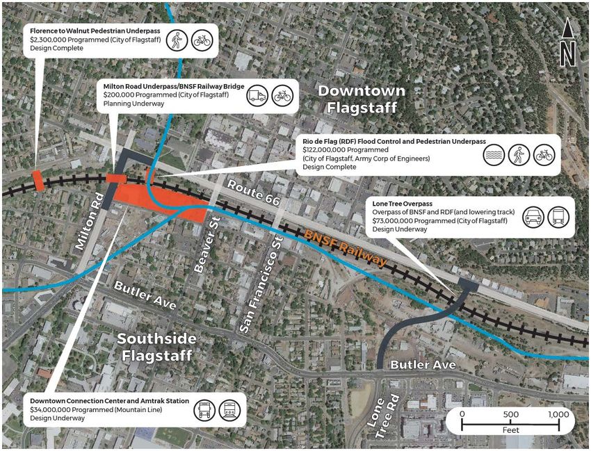
- 20 -Flagstaff Downtown Mile Project (PLANNING AND DESIGN PHASE)
FUND: TRANSPORTATION, STORMWATER, AGING INFRASTRUCTURE, BNSF RAILWAY, METROPLAN, GRANTS
Description - The Downtown Mile Project consists of a group of City and local agency projects located in Downtown
Flagstaff and surrounding the BNSF Railway corridor. They include:
• The Rio de Flag Flood Control Project
• The Rio de Flag Pedestrian Tunnel
• The Lone Tree Overpass
• The Florence to Walnut Pedestrian Underpass
• The Mountain Line Downtown Connection Center (DCC)
• The Milton Bridge Reconstruction
The city has partnered with ADOT, BNSF Railway, Mountain Line, Amtrak, and the Army Corps of Engineers for
the overall Downtown Mile Project in order to coordinate existing funding, plan construction efficiencies
- 21 -surrounding the BNSF corridor, investigate multimodal connectivity, and to seek grant funding for unfunded
BNSF mitigation measures to deliver these projects for the Flagstaff community.
The City applied for a USDOT RAISE Planning Grant in July 2021 to fund these planning activities and we received
notice in early November that we were not successful. In lieu of the grant, supplemental funding from the City
of Flagstaff, MetroPlan, and BNSF has been dedicated to continue the planning and design effort.
The current updates for the projects included in the Downtown Mile are as follows:
Rio de Flag Flood Control Project (Design Phase)
FUND: STORMWATER & AGING INFRASTRUCTURE
Description - Design consists of channel improvements along both the Rio de Flag and Clay Avenue Wash
channels through central Flagstaff and includes a combination of underground concrete box culverts, open
channel, and composite channel. The composite channel section has both an underground culvert to carry large
volumes of water and a smaller open channel on top, which will provide an aesthetic element of flowing surface
water during rainfall events. Total project length is approximately 15,000 feet.
The purpose of the Rio de Flag Flood Control Project is to remove the hazards associated with the hundred-year
storm event, which include property damage, life safety concerns, and community economic impacts. From
research conducted by the Army Corps, it was determined that a significant flood would damage approximately
1,500 structures valued at over $916M and cause $93M in economic damages, for a total impact of over $1
Billion dollars.
Project Update:
Work continued this month on refinement of the design plans and development of the real
estate documents. The Phase I legal descriptions were delivered to the Corps on December 9, in
accordance with our Real Estate schedule, for their review and development of the scope of
work documents for each parcel. This will allow for appraisals to begin.
On December 8, an executive meeting was held with City electeds and staff, the Army Corps,
and BNSF Railway to discuss expediting the Phase I Construction and Maintenance Agreement
(CMA). The group reached consensus to develop an agreement that represents design intent
and financial commitments for the Downtown Mile project (including the Rio de Flag) in order to
move forward with CMA 1 execution.
- 22 -Rio de Flag Pedestrian Tunnel (Design Phase)
FUND: STORMWATER & AGING INFRASTRUCTURE
Description - The Rio de Flag Pedestrian Tunnel will be constructed along with the flood control channel
improvements under the BNSF corridor. The undercrossing will also be constructed under the ADOT Route 66
corridor. This will be a FUTS facility which will link north downtown and City Hall with the Southside
neighborhood and the future Mountain Line DCC. Project progress will be reported in the Rio de Flag Flood
Control Project item above.
Lone Tree Overpass Project (DESIGN PHASE)
FUND: TRANSPORTATION
Description - The Lone Tree Overpass Project will provide a grade-separated crossing over the future Rio de Flag
drainage and the BNSF Railway corridor from Butler Avenue to Route 66. Funding for this project is provided
through voter approved bonds as designated in the 2018 Proposition 420. The project will also include
improvements from Butler south to Sawmill Road, which will be funded by Proposition 419. The project will be
delivered via the Design-Build process and the team includes Ames as the contractor and WSP as the prime
design consultant.
Project Update:
• Property acquisition is proceeding with appraisals, relocations, and offers to property owners.
• Several meetings were held to discuss and develop the revised Butler/Lone Tree intersection
alternatives per Council direction from October 19, including a meeting on December 9 with
Sustainability staff.
• On December 6, City Engineering staff and Flagstaff Bicycling Organization members met to discuss
project design and bicycle facilities.
- 23 -• A project update to the City Council is scheduled for the January 25 Work Session. Staff’s intent is to
bring back to Council design alternatives based on feedback received from Council on October 19,
2021.
Florence to Walnut Pedestrian Tunnel (Design Phase)
FUND: TRANSPORTATION
Description - Design consists of a FUTS undercrossing of the BNSF corridor that will link Walnut Street and
Florence Street in the La Plaza Vieja neighborhood. This project is in the approved La Plaza Vieja Neighborhood
Specific Plan and is designed and funded. Upon investigation of the final rail relocation, the design will most
likely need to be modified.
Milton Bridge Reconstruction (Planning Phase)
FUND: STORMWATER, AGING INFRASTRUCTURE, AND TRANSPORTATION
Description - The City is currently investigating reconstruction of the existing Milton Bridge structure to
accommodate a third mainline track for BNSF and to provide a standard bridge clearance. The current clearance
is 13’9” and the standard height is 16’6”. The realignment and reconstruction will allow the City to construct the
structures for both the Florence to Walnut pedestrian undercrossing and the Rio de Flag flood way and
pedestrian tunnel while minimizing operational impacts and construction risk to the BNSF mainline. A minimum
of two active tracks are required to be maintained for BNSF operations.
Project Update:
• Concept design efforts on the Milton Bridge reconstruction continues. Phase II of the preliminary
engineering study is due in January 2022.
- 24 -Mountain Line Downtown Connection Center (Design Phase)
FUND: GRANT
Description - The Downtown Connection Center is included in the Downtown Mile project report due to the
City’s partnership with Mountain Line for developing the site and the opportunity to plan the facility with
multimodal connections with the rest of the Downtown Mile projects. There are also current discussions for
future co-location of the Amtrak Station.
Project Update:
• The City is facilitating coordination of the DCC site improvements with the future Rio de Flag
construction.
• On December 7, City staff and Mountain Line presented the Parking Demand Study for the
site to City Council, which was approved.
• The DCC received CUP approval from the Planning & Zoning Commission on December 8.
• Mountain Line continues its effort to the NEPA work as required by the Federal Transit
Authority.
• Staff has begun to prepare an IGA that will be negotiated with Mountain Line following the
completion of the NEPA. Mountain Line hopes to have the IGA before the City Council in
May 2022 for approval.
• Mountain Line plans to begin construction of its building in Phase I this Summer (2022).
- 25 -East Route 66 and El Paso Flagstaff Waterline Extension (CONSTRUCTION PHASE)
FUND: AGING INFRASTRUCTURE
Description – A utility improvements project that extends the 12” ductile iron waterline approximately 2,450 linear feet
from approximately the intersection of Test Dr. and Rt. 66 to the intersection of El Paso Flagstaff Rd. The waterline
extension continues north, up El Paso Flagstaff Road towards the Wildcat Hill Wastewater Treatment plant, with
approximately 1,600 linear feet of new 8” ductile iron waterline. The project also calls for a repaving of El Paso Flagstaff
Road for the extents of the waterline extension.
Contractor – Scholz Contracting, LLC
Project Update:
• Staff is working with the Contractor to establish a Notice to Proceed for March 14th, 2022 with expected
completion in Summer of 2022.
Approved Civil Plans, blue line represents the starting point of the waterline extension that begins just west of the ADOT facilities
driveway and Rt 66 intersection.
- 26 -Huntington Waterline Replacement (CONSTRUCTION PHASE)
FUND: AGING INFRASTRUCTURE
Description - The Project consists of installing 3,000 LF of new 16” ductile iron waterline, and associated roadway
improvements. Included in the project will be new water services, fire hydrants and air release valves. The existing
waterline in this area is over 60 years old. This project is part of the City’s ongoing aging water infrastructure
replacement program.
Contractor – Sellers and Sons, Inc.
Project Update:
• Crews are on schedule to finish construction of the waterline replacement on December 23, 2021,
completing the project, a month ahead of schedule.
• Crews have been constructing on average 250 linear feet of waterline per day for Phase 2.
• The Contractor started on Phase 2 of the waterline replacement on November 26th
• The contractor and City continue to coordinate with property owners for the removal of
obstructions.
Installation of the 16” waterline replacement
- 27 -Phoenix Avenue Bridge and Waterline Replacement (Construction PHASE)
FUND: STORMWATER & AGING INFRASTRUCTURE
Description - The project will replace the Rio de Flag box culvert (which runs beneath Phoenix Avenue and the Zani
building, and functions as the Phoenix Ave bridge) with the appropriate conveyance structure and will upsize the current
waterline to a 12” waterline in Phoenix Avenue from Mikes Pike to Beaver Street. Phoenix Avenue will be reprofiled and
lowered to achieve a standard street section, roadway surface drainage issues will be addressed, edge improvements
will be made as needed and the roadway will be repaved. The existing waterline in this area is over 114 years old. This
project is part of the City’s ongoing aging water infrastructure replacement program.
Project Update:
• Dec. 13th – FRP Construction started the prep work for the QuakeWrap installation on the Zani Beam.
• Dec. 8th – Gabion basket placement for eastern and western channels was completed
• Dec. 3rd - The western waterline replacement became substantially complete.
• Dec. 1st- Structural backfill was completed and placement of the gabion baskets that line the box
culvert began.
Phoenix Avenue Bridge, looking west at structrual backfill placement in the western channel and completed gabion basket
placemement in the easter channel
- 28 -Phoenix Avenue Bridge, looking west at the westerrn waterline replacement
- 29 -Library Entrance (DESIGN PHASE)
FUND: BBB - BEAUTIFICATION
Description – Project to bring Library Entrance into ADA compliance with new handicap ramp and new overall vision for
the entrance. Public art will be incorporated into project and an artist is being brought onto the design team. Project
includes upgrades to landscaping, handicap-accessible parking, parking lot, and hardscape.
Project Update:
• The selected concept plan has been found complete as part of the City IDS Concept Plan review process.
• The project team, working with the artist, fabricator, and Risk Management, has addressed the safety
concerns brought up at City Council.
• The project team will continue work on project phasing details and maintaining access to the Library
throughout construction.
• The project is incorporating IT Fiber conduits to support the Broadband Master Plan and future
connections.
• The construction plans and lighting permit application are expected to be resubmitted in early January.
• An ADA specialist third party reviewer is slated to review plans for ADA compliance in early January.
Library Entrance Project-Rendering of selected concept plan
- 30 -Lockett/Fourth Roundabout (DESIGN PHASE)
FUND: HSIP GRANT
Description – Project consists of the design and construction of a new roundabout at the Lockett-Cedar-Fourth Street
intersection. Project is funded by an HSIP Grant, with supplementary funding from City of Flagstaff. Project design and
construction to be administered by ADOT. The new roundabout will improve safety and operations for vehicles,
pedestrians and bicyclists in this busy intersection. Project design and construction to be administered by ADOT.
Project Update:
• The project team has completed reviewing the 60% plan submittal.
• Environmental clearance has been received.
• Project team is in discussions regarding allowable closures and maintenance of traffic options.
• The project team is working through the 60% design comment resolution process.
• The team is currently reviewing impacts to surrounding properties and working to mitigate impacts.
Selected Design Alternative- Lockett-Cedar-Fourth Intersection
- 31 -You can also read