African Centre of Meteorological Applications for Development (ACMAD)
←
→
Page content transcription
If your browser does not render page correctly, please read the page content below
INTRA-ACP CLIMATE SERVICES AND RELATED APPLICATIONS PROGRAMME

             African Centre of
Meteorological Applications for
       Development (ACMAD)                                     Technical note for
                                                               synoptic/mesoscale forecast

                                     Issued on: March 3rd, 2022
                        Validity period: March 4th to 8th 2022

                               previ@acmad.org     www. a c m a d . n e t / n e w/ N E W SI T EA CM A D   w w w.climsa.org   archive

                                                                                                                                       1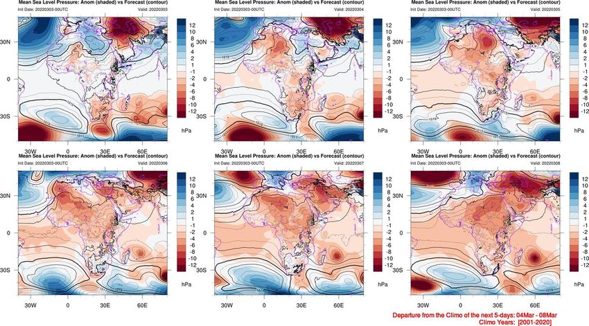
Contributors
            Name                               Function                                  Date
 Dr. Adamou Garba                Resource Person                                      03-03-2022

 Dr. Lawal Kamoru Abiodun        Thematic expert in Climate Change                    03-03-2022

 Godefroid Nshimirimana          Thematic expert in meteorology                       03-03-2022

 Maimuna Borno                   Resource Person                                      03-03-2022

 Leon Guy Razafindrakoto         Thematic expert in meteorology                       03-03-2022

 Dr. Pierre Kamsu                Senior Expert Forecaster                             03-03-2022
 Dr. Cheikh Dione                Research Scientist                                   03-03-2022

Versions
  Version             Date                    By                                         Descriptions
      V0            03-03-2022               WWFD forecasters     First draft for « Briefing », with all forecaster’s
                                                                  contributions
      V1            03-03-2022   Dr. Victor Indasi Ongoma & Dr.   Review
                                 Lawal Kamoru Abiodun

     Last           03-03-2022           Sunshine M. Gamedze      Review & Present                                      2
OUTLINE

     I     Forecast verification

         II Current conditions

     III Outlook
Table of Content
I. – Verification of forecasts
     1. Advisory verification
     2. Past days synoptic assessment: MSLP
        Past days synoptic assessment: Z500hPa
     3. Past day tropical waves impacts: 200hPa potential velocity anomalies
        Past day tropical waves impacts: 850hPa stream function anomalies

II. – Current situation
     1. IR10.8 Satellite Imagery
     2. 200hPa potential velocity anomalies and OLR prediction of MJO-related anomalies
     3. Current Tropical Cyclone
     4. Dust Haze at altitude at 09 UTC

III. – Outlook
     1. MSLP Synoptic Situation, D+1 to D+5
     2. Z500hPa forecast D+1 to D+5
     3. 925hPa Wind and humidity
     4. 850hPa Wind and humidity
     5. 700hPa Wind and humidity
     6. 700hPa streamline and humidity at 12UTC
     7. 700hPa streamline and humidity, daily mean
     8. 925-700hPa relative humidity at 12UTC
     9. 925-700hPa relative humidity, daily mean
     10. 925-700hPa vorticity at 12UTC
     11. 925-700hPa vorticity, daily mean
     12. ITD and ITCZ
     13. 200hPa and 850hPa potential velocity anomalies
     14. 200hPa and 850hPa stream function anomalies
     15.Precipitation Forecasts by ARP, GFS, UKMO, ECMWF and ICON models, D+1 to
     D+5
     16. Epsgram of precipitation (hot-spots)
     17. ARC2 climatology and climatology fror the next 5-days
     18. CHIRPS rainfall anomalies for the next 5-days
     19. Dust and visibility forecasts
     20. Hazard outlook                                                                   4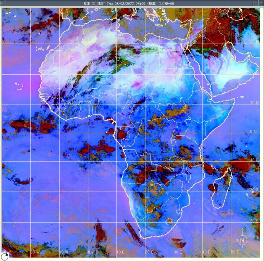
I     Forecast verification

    II Current conditions

III Outlook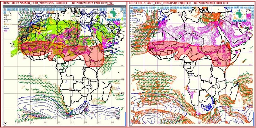
February 25th, 2022 (D+1)   February 26th, 2022 (D+2)   February 27th, 2022 (D+3)   February 28th, 2022 (D+4)

 Rain-gauge

   0mm
March 1st, 2022 (D+5)

Rain-gauge

    0mm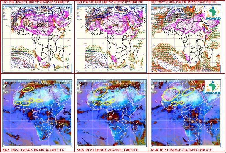
Forecast
Verification   I.2. Past days synoptic assessment: MSLP

                                                          8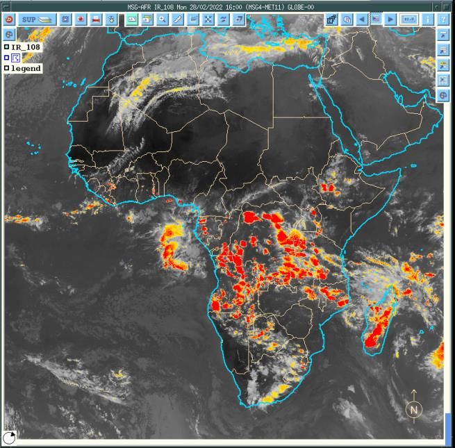
Forecast
Verification   I.2. Past day synoptic assessment: Z500hPa

                                                            9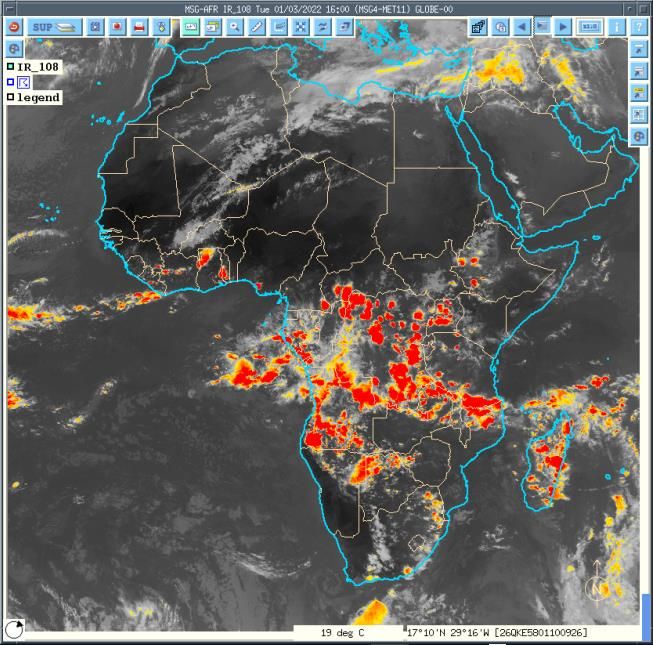
I.3. – Past day tropical wave impacts verification : 200hPa potential velocity anomalies

                                                                                           10
I.3. – Past day tropical wave impacts verification: 850hPa stream function anomalies
11I.4.- Dust forecast verification: February 28th to March 2nd, 2022
I     Forecast verification

    II Current situation

III Outlook

                              13
II.1. IR10.8 Satellite Imagery at 16UTC, February 26th to March 3rd, 2022
20220226 20220227 20220228
20220301 20220302 20220303
ºC
Convections started to shift northward and were located over Gulf of Guinea countries, Central African
Republic and Ethiopia. Whereas Convergence zones were observed over Madagascar, northern Mozambique,
western Tanzania, northern Zambia, Angola and Botswana. 14II. 2. - 200hPa potential velocity anomalies
Source: https:/www.cpc.ncep.noaa.gov
15II. 3. – Current Tropical Cyclone (VERNON) Source: http://www.meteo.fr/temps/domtom/La_Reunion/webcmrs9.0/francais/index.html 16
II.4.- Dust Haze on March 3rd, 2022 at 09UTC

Black circles identify areas of Dust/Haze observed at synoptical stations over some zones of Africa

                                                                                                 17
I Forecast verification
II Current conditions
III Outlook
18III.1.a - MSLP forecast, D+1 to D+5
19III.1.b – Climatology of the forecast period ( D+1 - D+5)
20III.1.c – Mean Sea Level Pressure Departure from Climo for the Next 5 Days
(Climo years: 2001-2020)
21III.1.d – Mean Sea Level Pressure departure from Climo of the next 5 days
(Climo years: 2001-2020)
22III.2.- Z500hPa forecast, D+1 to D+5
23III.3. Relative humidities
24III.3. 925hPa Wind and humidity
25III.4. 850hPa Wind and humidity
26III.5. 700hPa Wind and humidity
27III.6. Wind (925-700hPa) & and humidity (925 to 600hPa)
at 12UTC
Wind at 700hPa
Wind at 925hPa Data source: GFS model output
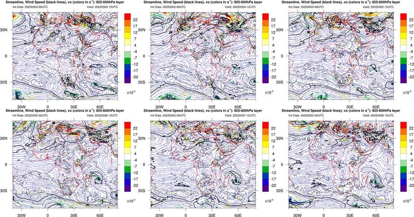
28III.8 – Streamline, wind speed and vorticity 925 to 600hPa,
at 12UTC
29III.9. - Intertropical Discontinuity (ITD)
20220303– 06UTC
20220304– 06UTC
20220305– 06UTC
20220306– 06UTC
FIT/ITD is expected to move northward during the
forecast period.
30III. 10. – MJO Forecast (ENS GFS Phase Diagram ) and Prediction of MJO phase impact on OLR
anomalies
twenty ensemble members
Ensemble mean Week 1
Week 2
90% of the members fall in this area
50% of the members fall in this area
Source: https:/www.cpc.ncep.noaa.gov
31III.11. - 200hPa and 850hPa «Potential velocity»
200hPa 850hPa
32III.12. - 200hPa and 850hPa «Stream function»
200hPa 850hPa
33III.13.a Dust and Visibility Forecasts D0, D+1 and D+2
2022/03/03 1200UTC 2022/03/04 1200UTC 2022/03/05 1200UTC
200mg m-3 , VIS < 3000 m 400mg m-3 , VIS > 600m < 1000 m
600mg m-3 , VIS > 200m < 600 m >1000mg m-3 , VIS < 200m
Visibility is expected to be reduced over Central Mauritania, eastern Mali, Niger, northern Nigeria, central Chad, Sudan
and Egypt. Visibility can also be slightly reduced over northen Cameroon. In theses areas winds are expected to be between
10 and 15 kts.
Data source: 1. NMMB bsc-dust-model (AEMET) ;
2. WMO No. 407 - Manual on the Observation of Clouds and other Meteors and in WMO No. 306 – Manual on 34
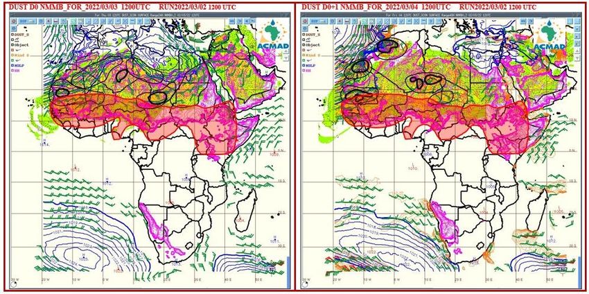
CodesIII.13.b. Dust and Meningitis Risk D0 and D+1
Black circles identify areas of high speed of wind which may lead to raising Dust storm. In these areas, low values
of surface relative humidity could raise the risk of meningitis. The shaded area is the Africa meningitis belt.
35III.13.c. Dust and Meningitis Risk D+2 and D+3
Black circles identify areas of high speed of wind which, is capable of raising of dust storm on the continent leading to high values of dust
surface concentrations. In these areas, low values of surface relative humidity could raise the risk of meningitis. The shaded area is the Africa
meningitis belt.
36rainy day III.15 - ARC2 Climatology of 1st dekad of March
>20mm/day
>50mm/day
37III.16. - ARC2 climatology
III.17- CHIRPS GEFS Total Rainfall anomalies
38III.18. – 5-days poor man’s ensemble (ARPEGE, ECMWF, UKMO, ICON, GFS)
(MEAN OF GEFS )III.19 -
40III.20- Tropical cyclogenesis outlook
Source: http://www.meteo.fr/temps/domtom/La_Reunion/webcmrs9.0/francais/index.html
41III.22 - Precipitation Forecasts by models (ARP, GFS, UKMO, ECMWF and ICON):
Day+1
GFS
ARPEGE UKMO
ECMWF ICON ECMWF/EFI
42III.22- Precipitation Forecasts by models (ARP, GFS, UKMO, ECMWF and ICON):
Day+2
GFS
ARPEGE UKMO
ECMWF ICON ECMWF/EFI
43III.22- Precipitation Forecasts by models (ARP, GFS, UKMO, ECMWF and ICON):
Day+3
GFS
ARPEGE UKMO
ECMWF ICON ECMWF/EFI
44III.22- Precipitation Forecasts by models (ARP, GFS, UKMO, ECMWF and ICON):
Day+4
GFS
ARPEGE UKMO
ECMWF ICON ECMWF/EFI
45III.22- Precipitation Forecasts by models (ARP, GFS, UKMO, ECMWF and ICON):
Day+5
GFS
ARPEGE UKMO
ECMWF ICON ECMWF/EFI
46MULTI-HAZARD OUTLOOK
30
Validity: 2022-03-04
issued on 2022-03-03
20
10 Rain Wind Dust Meningitis
Very heavy Very strong Very heavy Very likely
>100mm >80kmh-1 >1000mg m-3
0
Heavy Strong Heavy Likely
50-100mm >65kmh-1 >600mg m-3
-10
Moderate Moderate Moderate Less likely
10 - 49mm >50kmh-1 >400mg m-3
-20
Light Light Light
1 - 10mmMULTI-HAZARD OUTLOOK
30
Validity: 2022-03-05
issued on 2022-03-03
20
10 Rain Wind Dust Meningitis
Very heavy Very strong Very heavy Very likely
>100mm >80kmh-1 >1000mg m-3
0
Heavy Strong Heavy Likely
50-100mm >65kmh-1 >600mg m-3
-10
Moderate Moderate Moderate Less likely
10 - 49mm >50kmh-1 >400mg m-3
-20
Light Light Light
1 - 10mmMULTI-HAZARD OUTLOOK
30 Validity: 2022-03-06
issued on 2022-03-03
20
10 Rain Wind Dust Meningitis
Very heavy Very strong Very heavy Very likely
>100mm >80kmh-1 >1000mg m-3
0
Heavy Strong Heavy Likely
50-100mm >65kmh-1 >600mg m-3
-10
Moderate Moderate Moderate Less likely
10 - 49mm >50kmh-1 >400mg m-3
-20
Light Light Light
1 - 10mmMULTI-HAZARD OUTLOOK
30
Validity: 2022-03-07
issued on 2022-03-03
20
10 Rain Wind Dust Meningitis
Very heavy Very strong Very heavy Very likely
>100mm >80kmh-1 >1000mg m-3
0
Heavy Strong Heavy Likely
50-100mm >65kmh-1 >600mg m-3
-10
Moderate Moderate Moderate Less likely
10 - 49mm >50kmh-1 >400mg m-3
-20
Light Light Light
1 - 10mmMULTI-HAZARD OUTLOOK
30
Validity: 2022-03-08
issued on 2022-03-03
20
10 Rain Wind Dust Meningitis
Very heavy Very strong Very heavy Very likely
>100mm >80kmh-1 >1000mg m-3
0
Heavy Strong Heavy Likely
50-100mm >65kmh-1 >600mg m-3
-10
Moderate Moderate Moderate Less likely
10 - 49mm >50kmh-1 >400mg m-3
-20
Light Light Light
1 - 10mmVIGILANCE MAP FOR HEAVY RAINFALL
4 – 8 March 2022
issued on 2022-03-03
Phenomenon: Phenomenon:
- In next 5 days accumulated rainfall is expected to - In next 5 days accumulated rainfall is expected to
be in range of 50mm to 100mm; be in the range of 100mm to 150mm;
Hazards : Hazards :
Heavy rainfall, flash flood, riverine flooding,
Moderate rainfall, flash flood, riverine flooding,
landslides, soil erosion and
landslides, soil erosion and
Lightning, strong winds,
Lightning likely
Potentials Impacts:
Potentials Impacts:
Displacements of people due to floods, outbreak of
Displacements of people due to floods, outbreak of
water borne diseases, damage of infrastructures
water borne diseases, damage of infrastructures
(roads, bridges, …)
(roads, bridges, …)
Measures/Advisories:
Measures/Advisories:
Update and implement Flood contingency plans,
Update and implement Flood contingency plans,
Improve water management in reservoirs and dams,
Improve water management in reservoirs and dams,
DRM authorities be ready to take adequate actions,
DRM authorities to monitor the situation and raise
DRM to be in touch with NHMSs for more details and
awareness, taking action is more likely, the situation
needs to be monitored closely with NHMSs identification of vulnerable area,You can also read