245 Great Western Highway, South Wentworthville - Planning Proposal Transport Impact Assessment
←
→
Page content transcription
If your browser does not render page correctly, please read the page content below
245 Great Western Highway, South
Wentworthville
Planning Proposal
Transport Impact Assessment

Prepared by: Stantec Australia Pty Ltd for Nick Ates c/o Mecone

on 15/02/2022

Reference: 301401363

Issue #: B

245 Great Western Highway,
South Wentworthville
Planning Proposal
Transport Impact Assessment

Client: Nick Ates c/o Mecone

on 15/02/2022

Reference: 301401363

Issue #: B

Quality Record
   Issue                   Date                  Description               Prepared By          Checked By        Approved By     Signed
                   A       28/01/2022            Final                     Connor Hoang         Ingrid Bissaker   Rhys Hazell     Rhys Hazell

                                                 Updated to
                   B       15/02/2022            include minor             Connor Hoang         Ingrid Bissaker   Rhys Hazell
                                                 design changes

                   © Stantec Australia Pty Ltd [ABN 17 007 820 322] 2021
                   The information contained in this document is confidential and
GTA Report (NSW)

                   intended solely for the use of the client for the purpose for which it has
                   been prepared and no representation is made or is to be implied as
                   being made to any third party. Use or copying of this document in
                   whole or in part without the written permission of Stantec Australia                            Melbourne | Sydney | Brisbane
                   constitutes an infringement of copyright. The intellectual property                                   Adelaide | Perth
                   contained in this document remains the property of Stantec Australia
INTRODUCTION

CONTENTS
1.   Introduction                                                                                 4

     1.1. Background                                                                              4

     1.2. Concept Development Proposal                                                            4

     1.3. Purpose of this Report                                                                  5

     1.4. References                                                                              5
2.   Existing Conditions                                                                          7

     2.1. Location                                                                                7

     2.2. Road Network                                                                            8

     2.3. M4 Smart Motorway                                                                       9

     2.4. Transport Network                                                                      10

     2.5. Walking and Cycling Infrastructure                                                     11

     2.6. Traffic Volumes                                                                        12

     2.7. Crash History Analysis                                                                 13
3.   Planning Proposal                                                                           15

     3.1. Overview                                                                               15

     3.2. Parking Provision                                                                      16

     3.3. Site Access and Loading/ Waste Collection                                              16
4.   Parking and Traffic Appraisal                                                               17

     4.1. Parking Assessment                                                                     17

     4.2. Site Layout Review                                                                     18

     4.3. Traffic Generation                                                                     19
5.   Conclusion                                                                                  20

Appendices
A.   Vehicle Swept Paths

                                                      301401363 // 15/02/22
                                                      Transport Impact Assessment // Issue: B
                                                      245 Great Western Highway, South Wentworthville,
                                                      Planning Proposal                                  2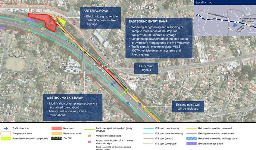
INTRODUCTION

Figures
    Figure 2.1:   Subject site and its environs                                                       7
    Figure 2.2:   Land use map                                                                        8
    Figure 2.3:   M4 on-ramp works east of the site                                                  10
    Figure 2.4:   Surrounding bus network                                                            11
    Figure 2.5:   Surrounding cycle network                                                          12
    Figure 2.6:   Crash map from 2015 to 2019                                                        13

Tables
    Table 2.1:    Bus services description                                                           10
    Table 2.2:    Weekday traffic volumes data 2019                                                  12
    Table 2.3:    Recorded crashes from 2015 to 2019                                                 13
    Table 4.1:    Statutory car parking requirements                                                 17
    Table 4.2:    Evening peak hour traffic generation estimates                                     19

                                                          301401363 // 15/02/22
                                                          Transport Impact Assessment // Issue: B
                                                          245 Great Western Highway, South Wentworthville,
                                                          Planning Proposal                                  3
INTRODUCTION

1. INTRODUCTION
1.1. Background
A planning proposal is to be lodged with Cumberland City Council to increase building height and floor space
ratio (FSR) and permit additional uses by amendment to the Cumberland Local Environment Plan 2020. The
purpose of the planning proposal is to enable a mixed-use development comprising a new hotel/ motel and
adaptive reuse of the existing heritage building for use as a café/ restaurant on the site at 245 Great Western
Highway, South Wentworthville.

Stantec was engaged to prepare a Traffic Impact Assessment to accompany the planning proposal.

1.2. Concept Development Proposal
The planning proposal seeks to amend the Cumberland Local Environmental Plan 2020 to:

•    Allow for permitted uses to include ‘hotel or motel accommodation’ and ‘food and drink premises’ under
     the R2 Low Density Residential zone.
•    Increase existing height controls of nine metres (two storeys) to 21 metres (equivalent to six storeys).
•    Increase the existing FSR from 0.5:1 to a nominated ratio that would facilitate a 100 room hotel/ motel
     (to be confirmed as part of design development).

The concept design includes a five-storey hotel/ motel development with rooftop dining providing 76 rooms
including studios and one and two-bedroom rooms. Other facilities would include pool, gymnasium,
conference room, and health and well-being centre.

The intention of the development is to restore the existing heritage listed cottage with a proposal to use as a
café/ restaurant surrounded by landscaped garden areas.

The proposal includes 79 on-site parking spaces for use by the hotel/ motel and ancillary café/ restaurant,
including three spaces to be signposted for use by service vehicles during the day and to serve as restaurant
visitor parking on evenings. Six motorcycle spaces and an additional hotel/ motel loading bay for use by vans/
utes and small rigid vehicles are also included. The indicative site layout is shown in Figure 1.1.

                                                             301401363 // 15/02/22
                                                             Transport Impact Assessment // Issue: B
                                                             245 Great Western Highway, South Wentworthville,
                                                             Planning Proposal                                    4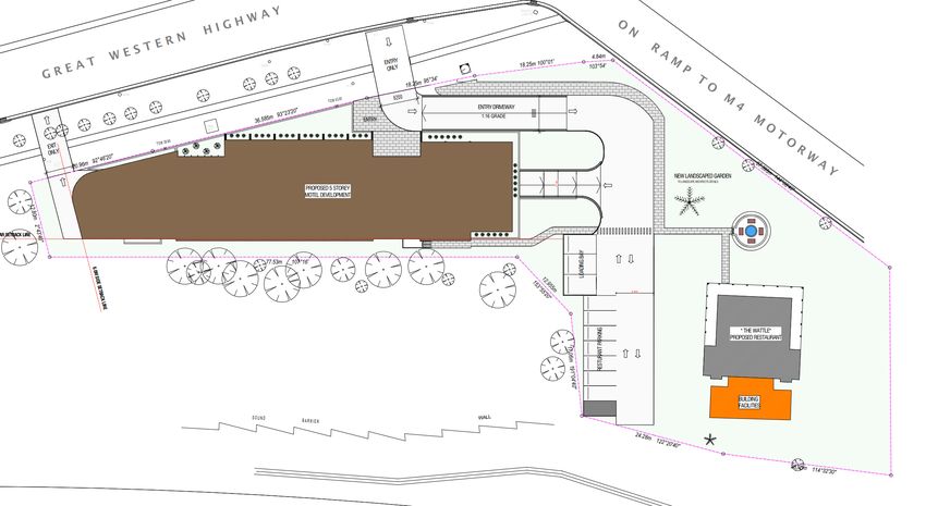
INTRODUCTION

Figure 1.1: Indicative site layout

1.3. Purpose of this Report
This report sets out an assessment of the anticipated transport implications of the proposed development,
including consideration of the following:

•    existing traffic and parking conditions surrounding the site
•    suitability of the proposed parking in terms of supply (quantum) and layout
•    service vehicle requirements
•    pedestrian and bicycle requirements
•    the traffic generating characteristics of the proposed development
•    suitability of the proposed access arrangements for the site
•    the transport impact of the concept development proposal on the surrounding road network.

1.4. References
In preparing this report, reference has been made to the following:

•    Holroyd Development Control Plan (DCP) 2013
•    Holroyd Local Environmental Plan (LEP) 2013
•    Draft Cumberland Development Control Plan 2020
•    Australian Standard/ New Zealand Standard, Parking Facilities, Part 1: Off-Street Car Parking AS/NZS
     2890.1:2004
•    Australian Standard, Parking Facilities, Part 2: Off-Street Commercial Vehicle Facilities AS 2890.2:2018

                                                             301401363 // 15/02/22
                                                             Transport Impact Assessment // Issue: B
                                                             245 Great Western Highway, South Wentworthville,
                                                             Planning Proposal                                  5
INTRODUCTION

•   Australian Standard / New Zealand Standard, Parking Facilities, Part 6: Off-Street Parking for People
    with Disabilities AS/NZS 2890.6:2009
•   plans for the proposed development prepared by White Stars Development, Job no. 21276, Issue C,
    dated 11 February 2022
•   other documents and data as referenced in this report.

                                                           301401363 // 15/02/22
                                                           Transport Impact Assessment // Issue: B
                                                           245 Great Western Highway, South Wentworthville,
                                                           Planning Proposal                                  6
EXISTING CONDITIONS
2. EXISTING CONDITIONS
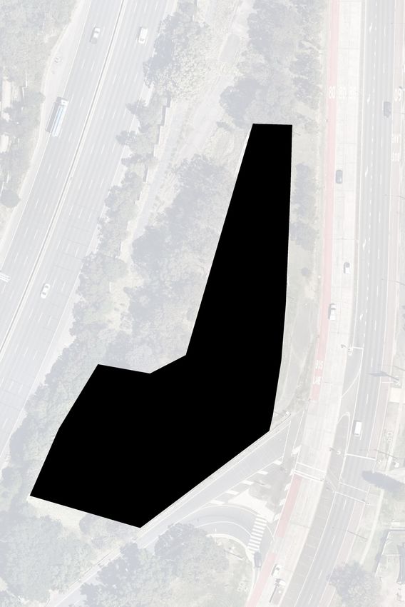
2.1. Location
The site is at 245 Great Western Highway, South Wentworthville on land between the M4 Western Motorway
and Great Western Highway. It has frontages of approximately 100 metres to Great Western Highway to the
north and 56 metres to the M4 on-ramp to the east. The existing site is largely vacant, with a two-storey
heritage listed cottage, ‘The Wattles’ in the south-east corner of the site.
The site is currently zoned R2 – Low Density Residential and is surrounded a mix of residential housing types.
The location of the site and its surrounding environs is shown in Figure 2.1 with the LEP land use map shown
in Figure 2.2.
Figure 2.1: Subject site and its environs
301401363 // 15/02/22
Transport Impact Assessment // Issue: B
245 Great Western Highway, South Wentworthville,
Planning Proposal 7
EXISTING CONDITIONS

Figure 2.2: Land use map

2.2. Road Network
2.2.1. Road Hierarchy
Roads are classified according to the functions they perform. The main purpose of defining a road’s functional
class is to provide a basis for establishing the policies which guide the management of the road according to
their intended service or qualities.

In terms of functional road classification, State roads are strategically important as they form the primary
network used for the movement of people and goods between regions, and throughout the State. Transport
for NSW (TfNSW) is responsible for funding, prioritising and carrying out works on State roads. State roads
generally include roads classified as freeways, state highways, and main roads under the Roads Act 1993,
and the regulation to manage the road system is stated in the Australian Road Rules, most recently amended
on 19 March 2018.

TfNSW defines four levels in a typical functional road hierarchy, ranking from high mobility and low
accessibility, to high accessibility and low mobility. These road classes are:

Arterial Roads – Controlled by TfNSW, typically no limit in flow and designed to carry vehicles long distance
between regional centres.

Sub-Arterial Roads – Managed by either Council or TfNSW under a joint agreement. Typically, their operating
capacity ranges between 10,000 and 20,000 vehicles per day, and their aim is to carry through traffic
between specific areas in a sub region or provide connectivity from arterial road routes (regional links).

Collector Roads – Provide connectivity between local sites and the sub-arterial road network, and typically
carry between 2,000 and 10,000 vehicles per day.

                                                             301401363 // 15/02/22
                                                             Transport Impact Assessment // Issue: B
                                                             245 Great Western Highway, South Wentworthville,
                                                             Planning Proposal                                   8
EXISTING CONDITIONS
Local Roads – Provide direct access to properties and the collector road system and typically carry between
500 and 4,000 vehicles per day.
2.2.2. Surrounding Road Network
Great Western Highway
Great Western Highway is a classified State Road and key corridor running along the northern site boundary.
It is aligned in an east-west direction and provides two traffic lanes in each direction plus dedicated bus lanes
in each direction, set within a 24-metre-wide carriageway. It has a posted speed limit of 60 kilometres per
hour, increasing to 80 kilometres per hour immediately west of the site. Kerbside parking is not permitted on
both sides of the road.
M4 Western Motorway
The M4 Western Motorway is a classified State Road connecting Penrith with Auburn and aligned in an east-
west direction south of the site. It provides three eastbound and four westbound traffic lanes within a 28-
metre-wide carriageway. It has a posted speed limit of 90 kilometres per hour with local area access via the
eastbound on-ramp along the eastern boundary of the site. The on-ramp allows Great Western Highway
traffic to enter the M4 via traffic signals that also facilitate the safe crossing of pedestrians across the Great
Western Highway.
Modifications to the on-ramp east of the site on the M4 alignment itself are planned as part of the M4 Smart
Motorway project, as detailed in Section 2.3.
Bridge Road
Bridge Road is a local road connecting with Great Western Highway at a signalised intersection 100 metres
east of the site. It provides one traffic lane and one parking lane in each direction, set within a 12-metre-wide
carriageway. It has a posted speed limit of 50 kilometres per hour with school zone restrictions in place
during the school peak periods. Parking is permitted on each side of the road, with restrictions in place during
school hours.
2.2.3. Surrounding Intersections
The key intersections in the vicinity of the site include:
• Great Western Highway / M4 on-ramp (signalised)
• Great Western Highway / Bridge Road (signalised).
2.3. M4 Smart Motorway
TfNSW has proposed to introduce intelligent technology to the M4 Motorway between the Pitt Street
overpass in Parramatta and Great Western Highway in Lapstone. The works will involve the following:
• introduction of Intelligent Traffic Systems (ITS)
• interchange works including widening, lengthening and re-alignment of the entry/ exit ramps, installing
ITS infrastructure and minor modifications to arterial and major road intersections connecting to the
motorway
• widening a 4.3-kilometre section of the M4 Motorway between Roper Road and Westlink M7
interchanges.
301401363 // 15/02/22
Transport Impact Assessment // Issue: B
245 Great Western Highway, South Wentworthville,
Planning Proposal 9EXISTING CONDITIONS
This specifically includes works of the section of the M4 on-ramp from the Great Western Highway to provide
greater storage capacity and merge lengths. Electronic signage and vehicle detection devices would also be
installed in this location.
The proposed works as part of the M4 Smart Motorway project at the on-ramp adjacent to the site are shown
in Figure 2.3 with no impacts on the site anticipated.
Figure 2.3: M4 on-ramp works east of the site
2.4. Transport Network
The site is adequately serviced by public transport with a bus stop 130 metres east of the site on Great
Western Highway. The bus stop services three bus routes as summarised in Table 2.1 and shown in Figure
2.4.
Table 2.1: Bus services description
Frequency
Route Description
Peak Off-Peak
Merrylands to Parramatta
810X 15 minutes 60 minutes
via Pemulwuy
Pemulwuy to Parramatta via
811X 25 minutes 60 minutes
Beresford Road
Liverpool to Parramatta via
T80 10 minutes 30 minutes
T-way
301401363 // 15/02/22
Transport Impact Assessment // Issue: B
245 Great Western Highway, South Wentworthville,
Planning Proposal 10EXISTING CONDITIONS
Figure 2.4: Surrounding bus network
Source: Transit Systems western network map, accessed October 2021
2.5. Walking and Cycling Infrastructure
The site has adequate access to walking infrastructure. A footpath is provided on the northern side of Great
Western Highway and on both sides east of the Bridge Road intersection further to the east. Formalised
crossing points exist at the M4 on-ramp intersection and at the Bridge Road traffic signals.
An on-road cycling path exists on the M4 and on select local streets in the vicinity. The surrounding cycling
map is shown in Figure 2.5.
301401363 // 15/02/22
Transport Impact Assessment // Issue: B
245 Great Western Highway, South Wentworthville,
Planning Proposal 11EXISTING CONDITIONS
Figure 2.5: Surrounding cycle network
Base image source: roads-waterways.transport.nsw.gov.au/maps
2.6. Traffic Volumes
TfNSW provides average road traffic volumes for a selection of permanent and sample roadside collection
device stations at key locations across New South Wales. The closest traffic volume station (Station Id:
68025) is located on the Great Western Highway about 300 metres east of the site. Data indicates that along
the site frontage, Great Western Highway carries an Annual Average Daily Traffic (AADT) volume of around
36,500 vehicles. No discernible growth between 2009 to 2019 was observed with volumes decreasing by
approximately four per cent over the 10-year period.
A summary of the weekday morning and evening peak hour 2019 traffic volumes is summarised in Table 2.2.
Data for 2020 and 2021 were excluded due to travel restrictions associated with COVID-19. The data
confirms the tidal nature of traffic in the area with the evening having higher volumes than the morning peak
hour.
Table 2.2: Weekday traffic volumes data 2019
Period Direction Vehicles
AM Eastbound 1,314
(8:00am-9:00am) Westbound 929
PM Eastbound 1,046
(5:00pm-6:00pm) Westbound 1,721
301401363 // 15/02/22
Transport Impact Assessment // Issue: B
245 Great Western Highway, South Wentworthville,
Planning Proposal 12EXISTING CONDITIONS
2.7. Crash History Analysis
An analysis of the most recent five-year period of available crash data (2015-2019) has been undertaken
based on crash data provided by TfNSW for the roads surrounding the site. The locations and severity of the
crash data for the five-year period is shown in Figure 2.6 and detailed in Table 2.3.
Figure 2.6: Crash map from 2015 to 2019
Base image source: TfNSW Centre for Road Safety Interactive Crash Map
Table 2.3: Recorded crashes from 2015 to 2019
Location Location ID Number of crashes Number of Injuries
Great Western Highway/
1 3 3
M4 Motorway
Great Western Highway 2 2 1
Great Western Highway/
3 32 23
Bridge Road
Great Western Highway/
4 36 32
Coleman Street
Total 73 59
The following key statistics can be drawn from the crash data:
• No fatalities were recorded during the five-year period.
• Approximately 75 per cent of crashes resulted in an injury.
• Over the five-year period 73 incidents occurred at key intersections surrounding the site with right
through accounting for 37 per cent and rear ends 31 per cent of these.
• 14 per cent of incidents resulted in serious injury.
• Majority of incidents occurred at the Great Western Highway/ Bridge Road and Great Western Highway/
Coleman Street intersections, accounting for 93 per cent of incidents.
• Only three incidents occurred along the site frontage.
301401363 // 15/02/22
Transport Impact Assessment // Issue: B
245 Great Western Highway, South Wentworthville,
Planning Proposal 13EXISTING CONDITIONS
Although the surrounding roads have a crash history, these are largely clustered in and around the
intersections and not along the site frontage. No incidents were attributed to vehicles exiting a driveway. As
such, the in/ out movements are not anticipated to result in further traffic incidents. Notwithstanding
comparable developments have access on Great Western Highway.
In addition, the site would generate relatively low volumes and could not be expected to impact the safety of
the surrounding road network.
301401363 // 15/02/22
Transport Impact Assessment // Issue: B
245 Great Western Highway, South Wentworthville,
Planning Proposal 14PLANNING PROPOSAL
3. PLANNING PROPOSAL
3.1. Overview
The concept plan supporting the planning proposal incorporates a five-storey hotel/ motel development and
rooftop dining level. The concept design indicates that the planning proposal could provide for 76 rooms,
hotel facilities such as a gymnasium, health and well-being centre and conference room, and rooftop terrace
dining across 4,560 square metres Gross Floor Area (GFA). The potential room breakdown is as follows:
• 40 studio units
• 32 one-bedroom units
• 4 two-bedroom units.
The existing heritage cottage is proposed to be converted into a café/ restaurant covering 203 square metres
GFA of dining area. It is expected to operate as very much ancillary to the hotel/ motel with much demand
expected from hotel/ motel guests, and to also be open to the public.
Site access is proposed via separate entry and exit driveways on the Great Western Highway, restricted to
left turns only. To ensure connection with the broader pedestrian network, a footpath is proposed along the
site frontage connecting with the crossing facilities at the Great Western Highway/ M4 on-ramp intersection.
The indicative site layout is shown in Figure 3.1.
Figure 3.1: Indicative site layout
Source: White Stars Development, project no. 21276, drawing no. A101, issue C, dated 11 February 2022
301401363 // 15/02/22
Transport Impact Assessment // Issue: B
245 Great Western Highway, South Wentworthville,
Planning Proposal 15PLANNING PROPOSAL
3.2. Parking Provision
The proposal includes 79 on-site parking spaces for use by the hotel/ motel and ancillary café/ restaurant.
This comprises 69 spaces (including five accessible spaces) within a two-level basement car park plus 10 at-
grade spaces close to the heritage building (including three spaces signposted for service vehicles during the
day). Six motorcycle spaces and 14 bicycle spaces are also proposed within basement one.
3.3. Site Access and Loading/ Waste Collection
Two separate entry and exit driveway crossovers are proposed on the Great Western Highway. The eastern
driveway is proposed about 25 metres west of the M4 on-ramp traffic signals and will facilitate all entering
vehicles, with the western driveway allowing for all exit movements. The entry driveway is in about the same
location as the existing driveway crossover. Both driveways also allow for the necessary sightlines, ensuring
safe and appropriate site access given the posted speed limit and absence of conflicting movements through
the area. All vehicles would enter and exit the site in a forward direction.
Hotel/ motel loading is proposed within basement one close to the car park entry ramp with management
measures to ensure practical access to the waste storage room. The loading bay would accommodate
vehicles up to 6.4 metres long with the loading bay also having capacity for two vans/ utes, as demand
requires.
Three loading bays are also proposed within the at-grade car park close to the heritage building. These
spaces are proposed to be signposted for use by service vehicles during the day and as visitor parking during
the evening. The loading bays would accommodate vans/ utes, with at least the southern space also
appropriate for use by small rigid vehicles.
301401363 // 15/02/22
Transport Impact Assessment // Issue: B
245 Great Western Highway, South Wentworthville,
Planning Proposal 16PARKING AND TRAFFIC APPRAISAL
4. PARKING AND TRAFFIC
APPRAISAL
4.1. Parking Assessment
4.1.1. Preamble
Cumberland Council is in the process of renewing the LEP and DCP that apply to the Local Government Area
(LGA) following Council boundary changes. The documents are currently in draft with the public exhibition
period closing in May 2020.
While Holroyd DCP 2013 remains the formal reference document, parking requirements have been assessed
under both DCP rates.
4.1.2. Car Parking
A review of both DCP’s indicate consistent parking requirements, with the only difference being the minimum
parking rate for café/ restaurant uses varies between one per 7 to 8 square metres. These rates are also
consistent with the requirements set out in the TfNSW Guide to Traffic Generating Developments (the Guide)
2002.
Parking requirements for the development are summarised in Table 4.1 and indicate the need for up to 110
on-site parking spaces.
Table 4.1: Statutory car parking requirements
Land Use Size Parking Rate Parking Requirement
1 space per room/ unit
Hotel/ motel 76 rooms 81
plus 1 space per 2 employees [1]
Café/ restaurant 203m2 1 space per 7-8m2 25-29
Total 106-110
[1] Assume 10 rostered hotel/ motel employees
4.1.3. Proposed Parking Provision
It is important to recognise the intended daily use of the site and how this effects the quantum of parking
required. In this regard, hotel/ motel visitors are expected to make up a significant proportional use of café/
restaurant demand, with a corresponding 75 per cent discount applied to the café/ restaurant to reflect the
practical or ‘real’ use of the heritage building. This would equate to the need for about six to seven spaces for
the café/ restaurant.
On this basis, the development would be required to provide around 87 parking spaces. With a proposed
parking supply of 79 spaces plus six motorcycle spaces in the basement, the concept proposal falls
marginally short of the theoretical maximum demand generally meets the required parking supply of all
relevant statutory guidelines. Overall, the proposed parking provision is expected to provide for the proposal
with further detailed assessment to be included as part of any future development application.
301401363 // 15/02/22
Transport Impact Assessment // Issue: B
245 Great Western Highway, South Wentworthville,
Planning Proposal 17PARKING AND TRAFFIC APPRAISAL
4.1.4. Accessible Parking
Holroyd DCP 2013 requires that two spaces per 100 visitor/ customer spaces be designated as accessible
parking. As such two accessible spaces would be required as part of any future development application.
Indicative plans indicate that five accessible spaces could be provided, exceeding this requirement.
4.1.5. Bicycle Parking
Neither Holroyd DCP 2013 nor the Draft Cumberland DCP stipulates any bicycle requirements for hotel land
uses. Plans indicate that 14 bicycle parking spaces would be provided with this deemed suitable given
surrounding cycling infrastructure.
The café/ restaurant will need direct use of two bicycle spaces recommended to be provided as loops close
to heritage building.
Bicycle parking spaces, as a minimum, need to be designed in accordance with relevant Australian Standard
(AS2890.3 Bicycle Parking Facilities).
4.1.6. Loading Requirements
For hotel accommodation, Draft DCP 2020 and TfNSW Guidelines stipulate a loading requirement of one
space per 50 bedrooms or bedroom suites, up to 200 bedrooms. This equates to two loading bays for the
hotel use, with the basement loading area able to practically accommodate two smaller service vehicles,
such as vans and utes for daily deliveries. As is typical for hotel operations, basic management and timing of
deliveries by small rigid trucks would be in place to ensure appropriate use. Deliveries would also be spread
across the day and week with no distinct peak period.
The concept proposal also requires one loading bay for the café/ restaurant use of the heritage building.
Deliveries would also occur outside restaurant/ café peak periods and in the three at-grade spaces that are
to be dedicated for service vehicles during the day.
On this basis the proposed loading arrangements and simple management measures are considered
suitable.
4.2. Site Layout Review
A high-level review of the car park and site layout has been completed against the requirements of the
Australian Standard for Off Street Car Parking (AS/NZS2890.1:2004). Overall, the car park is expected to
operate efficiently, with the concept design to be further developed as part of any future development
application.
Car parking spaces should be designed to a minimum 2.4 or 2.5 metres wide and 5.4 metres long, with a
minimum 5.8 metres provided for adjacent parking aisles in accordance with AS2890.1. Accessible parking,
including height clearances of 2.5 metres above the accessible spaces and shared areas should be designed
in accordance with AS2890.6. The loading area and travel paths to and from would be designed in
accordance with AS2890.2, with minimum 3.5 metre height clearances to services and structure.
The concept design of the access driveways, on-site parking and loading areas will be further detailed as part
of any future development application, with circulation aisles, car space and loading bay dimensions and
height clearances to be designed in accordance with relevant Australian Standards (AS2890 series).
301401363 // 15/02/22
Transport Impact Assessment // Issue: B
245 Great Western Highway, South Wentworthville,
Planning Proposal 18PARKING AND TRAFFIC APPRAISAL
4.3. Traffic Generation
Traffic generation estimates for the proposed development have been sourced from TfNSW Guidelines. The
estimated evening peak hour traffic volumes generated by the development are summarised in Table 4.2.
Table 4.2: Evening peak hour traffic generation estimates
Land Use Size Traffic Generation Rate Traffic Generation
Hotel/ motel 76 rooms 0.4 vehicle trips per room 30
Café/ restaurant 203m GFA
2
5 vehicle trips per 100m GFA
2
10
Total 40 trips
Table 4.2 indicates the site would generate up to 40 vehicle trips during the evening peak hour. On the basis
that the café/ restaurant also operates ancillary to the hotel, traffic generation would be about 30 to 35
vehicle trips.
All site generated traffic would approach from the east and depart to the west along the Great Western
Highway. Given the low traffic volumes generated by the proposal (representing about two per cent of the
westbound evening peak hour traffic volumes as detailed in Section 2.6), this additional traffic is not expected
to noticeably change the safety or function of the surrounding road network.
301401363 // 15/02/22
Transport Impact Assessment // Issue: B
245 Great Western Highway, South Wentworthville,
Planning Proposal 19CONCLUSION
5. CONCLUSION
Based on the analysis and discussions presented within this report, the following conclusions are made:
• A planning proposal for land at 245 Great Western Highway, South Wentworthville is to be lodged with
Cumberland City Council for amendments to the Cumberland LEP 2020 to enable a mixed-use
development comprising a hotel and ancillary café/ restaurant use. The café/ restaurant proposes to
adaptively reuse of the existing heritage building on the site.
• The concept design indicates the five-storey hotel could provide for 76 rooms, hotel facilities and rooftop
hotel terrace dining across 4,560 square metres GFA. The existing heritage cottage covers 203 square
metres GFA.
• The concept proposal includes 79 on-site parking spaces for use by the hotel/ motel and ancillary café/
restaurant. This includes 69 spaces (including five accessible spaces) within a two-level basement car
park plus 10 at-grade spaces close to the heritage building (including three spaces for service vehicles
during the day).
• Six motorcycle and 14 bicycle spaces are also proposed within basement one.
• A minimum of two accessible parking spaces would need to be provided as part of any future
development application.
• Based on the analysis of land uses and especially recognising the ancillary operation of the café/
restaurant, and hence daily practical use of the site, up to 87 to 88 parking spaces would be required to
adequately provide for the parking demands of the concept proposal.
• The concept proposal broadly meets this requirement by way of 79 parking spaces and six motorcycle
spaces with further detailed assessment to be included as part of any future development application.
• A dedicated loading bay with capacity for two small delivery vehicles (vans, utes etc.) or one 6.4 metre
small rigid vehicle is proposed within the basement and for use by the hotel. Café/ restaurant deliveries
would occur outside peak periods and in the three spaces close to the heritage building dedicated for
use by service vehicles during the day.
• Basic management of service vehicle deliveries is recommended to ensure appropriate use across the
day and week.
• A high-level review of the car park and site layout has been completed against the requirements of the
Australian Standard for Off Street Car Parking (AS/NZS2890.1:2004). Overall, the car park is expected
to operate well and to be further developed as part of any future development application.
• Based on the applicable rates in the TfNSW Guide, the proposal could generate up to 40 vehicle trips
during the evening peak hour. On the basis that the café/ restaurant operates ancillary to the hotel,
traffic generation would be about 30 to 35 vehicle trips and not expected to materially change the safety
or function of the surrounding road network.
301401363 // 15/02/22
Transport Impact Assessment // Issue: B
245 Great Western Highway, South Wentworthville,
Planning Proposal 20APPENDIX: VEHICLE SWEPT PATHS
A.VEHICLE SWEPT PATHS
A
301401363 // 15/02/22
Transport Impact Assessment // Issue: B
245 Great Western Highway, South Wentworthville,
Planning Proposal A-1GREAT WESTERN HIGHWAY
EXIT
ONLY
ENTRY
4510 ONLY
20.96m 92°46'20" TOW 39.90
36.585m 93°23'20" TOW 43.00
18.25m 95°34'
O
6200
12.80m 2°43'40"
18.25m 10
N
0°01'
ENTR
3.0M Y 4.84m
REAR SE
TB AC 103°54
R
K LIN '
E
ENTR
Y DRIV
A
EXIT
EWAY
EXIT
1:16
GRAD
M
HOTE E
L FAC
ILITIE
6000
S
P
STOR
PROP E
O EXIT
MOTE SED 5 ST
T
L DEV O
ELOP REY
MENT MEET
O
TION
6.0M SIDE SETBACK LINE
ING R
OOM
RECEP
LOBB
M
Y
E
FEATUR
4
WATER
TERR
ACE
77.53
M
m
4100
107°1 OFFIC
6' ES
O
T
NEW
O
LAND
TO LA SCAP
NDSC
APE AR ED GA
RDEN
R
CHITE
57
CTS DE
TAILS
.39
W
5m
14
A
4°
08
Y
'40
"
AY
ING B
NEW PA
TH
12. '20"
153
LOAD
955
°55
m
6200
SOU
ND
KING
BAR
RIER
17.06m
T PAR
URAN
191°04'4
REST
''
PROP THE WATT
OSED L
0"
REST E"
M4 WALL AURA
NT
MO
TO
RW
AY
BUILD
IN
24.
28m FACIL G
ITIES
122
°20
'40"
28.0
5m
114
°32
'30"
DESIGNED DESIGN CHECK SCALE 0 2.5 5 10 245-247 GREAT WESTERN HIGHWAY
NOW
PRELIMINARY PLAN WARNING M.RIMAC R.HAZELL A3 1:500
SOUTH WENTWORTHVILLE NSW 2145
BEWARE OF UNDERGROUND SERVICES
FOR DISCUSSION PURPOSES ONLY THE LOCATIONS OF UNDERGROUND SERVICES ARE GROUND LEVEL
SUBJECT TO CHANGE WITHOUT
GTAconsultants NOTIFICATION
APPROXIMATE ONLY AND THEIR EXACT POSITION
SHOULD BE PROVEN ON SITE. NO GUARANTEE IS
APPROVED BY DATE ISSUED CAD FILE NO. VEHICLE SWEPT PATH ASSESSMENT
GIVEN THAT ALL EXISTING SERVICES ARE SHOWN.
R.HAZELL 14 FEBRUARY 2022 301401363_01_P3.DWG
DRAWING NO. 301401363_01_01
3014013601 SHEET 01
---- OF 04
01 ISSUE P3EXIT ONLY 20.96m
92°46'20"
36.585m 93°23'20"
18.25m 95°34'
12.80m 2°43'40"
18.25m 10
0°01'
3.0M 4.84m
REAR S E
TBAC
K LIN
103°54
E '
SRV LO
ADING
2200
6.0M SIDE SETBACK LINE
BAY
3000
77.53
m
107°1
6'
57
.39
m 5
14
4°
08
'4
0"
12. '20"
153
955
°55
m
SOU
ND
BAR
RIER
17.06m
191°04'4
0"
M4 WALL
MO
TO
RW
AY
24.
28m
122
°20
'40
"
28.0
5m
114
°32
'30"
DESIGNED DESIGN CHECK SCALE 0 2.5 5 10 245-247 GREAT WESTERN HIGHWAY
NOW
PRELIMINARY PLAN WARNING M.RIMAC R.HAZELL A3 1:500
SOUTH WENTWORTHVILLE NSW 2145
BEWARE OF UNDERGROUND SERVICES
FOR DISCUSSION PURPOSES ONLY THE LOCATIONS OF UNDERGROUND SERVICES ARE BASEMENT 1
SUBJECT TO CHANGE WITHOUT
GTAconsultants NOTIFICATION
APPROXIMATE ONLY AND THEIR EXACT POSITION
SHOULD BE PROVEN ON SITE. NO GUARANTEE IS
APPROVED BY DATE ISSUED CAD FILE NO. VEHICLE SWEPT PATH ASSESSMENT
GIVEN THAT ALL EXISTING SERVICES ARE SHOWN.
R.HAZELL 14 FEBRUARY 2022 301401363_01_P3.DWG
DRAWING NO. 301401363_01_02
3014013602 SHEET 02
---- OF 04
01 ISSUE P3EXIT ONLY 20.96m EXIT ONLY 20.96m
92°46'20" 92°46'20"
36.585m 93°23'20" 36.585m 93°23'20"
18.25m 95°34' 18.25m 95°34'
12.80m 2°43'40"
12.80m 2°43'40"
18.25m 10 18.25m 10
0°01' 0°01'
3.0M 3.0M
R EAR S R EAR S
ETBA ETBA 1 103°54
CK LIN C K L0IN3°54' '
E E
SRV LO
SRV LO
ADING
ADING
2200
2200
6.0M SIDE SETBACK LINE
6.0M SIDE SETBACK LINE
BAY
BAY
3000
3000
77.53 77.53
m m
107°1 107°1
6' 6 '
12.
12.
153
153
955
955
°55
°55
m
m
'20"
'20"
SOU SOU
ND ND
BAR BAR
RIER RIER
17.06m
17.06m
191°04'4
191°04'4
0"
0"
M4 WALL
M4 WALL
MO MO
TO TO
RW RW
AY AY
24. 24.
28m 28m
122 122
°20 °20
'40" '40
"
DESIGNED DESIGN CHECK SCALE 0 2.5 5 10 245-247 GREAT WESTERN HIGHWAY
NOW
PRELIMINARY PLAN WARNING M.RIMAC R.HAZELL A3 1:500
SOUTH WENTWORTHVILLE NSW 2145
BEWARE OF UNDERGROUND SERVICES
FOR DISCUSSION PURPOSES ONLY THE LOCATIONS OF UNDERGROUND SERVICES ARE BASEMENT 1
SUBJECT TO CHANGE WITHOUT
GTAconsultants NOTIFICATION
APPROXIMATE ONLY AND THEIR EXACT POSITION
SHOULD BE PROVEN ON SITE. NO GUARANTEE IS
APPROVED BY DATE ISSUED CAD FILE NO. VEHICLE SWEPT PATH ASSESSMENT
GIVEN THAT ALL EXISTING SERVICES ARE SHOWN.
R.HAZELL 14 FEBRUARY 2022 301401363_01_P3.DWG
DRAWING NO. 301401363_01_03
3014013603 SHEET 03
---- OF 04
01 ISSUE P3GREAT WESTERN HIGHWAY GREAT WESTERN HIGHWAY
20.96m 92°46'20" 20.96m 92°46'20"
36.585m 93°23'20" 36.585m 93°23'20"
M/CYC
LE
18.25m 95°34' M/CYC 18.25m 95°34'
PLAN LE
T PLAN
T
12.80m 2°43'40"
STOR 18.25m 10
12.80m 2°43'40"
AGE 0°01' STOR 18.25m 10
AGE 0°01'
3205
3205
4.84m 4.84m
103°54 103°54
' '
77.53 77.53
m m
107°1 107°1
6' 6 '
12.
153
12. '20"
153
955
°55
955
°55
m
'20"
m
17.06m
17.06m
191°04'4
191°04'4
0"
0"
M4 M4
MO MO
TO TO
RW RW
AY AY
24. 24.
28m 28m
122 122
°20 °20
'40" '40
"
DESIGNED DESIGN CHECK SCALE 0 2.5 5 10 245-247 GREAT WESTERN HIGHWAY
NOW
PRELIMINARY PLAN WARNING M.RIMAC R.HAZELL A3 1:500
SOUTH WENTWORTHVILLE NSW 2145
BEWARE OF UNDERGROUND SERVICES
FOR DISCUSSION PURPOSES ONLY THE LOCATIONS OF UNDERGROUND SERVICES ARE BASEMENT 2
SUBJECT TO CHANGE WITHOUT
GTAconsultants NOTIFICATION
APPROXIMATE ONLY AND THEIR EXACT POSITION
SHOULD BE PROVEN ON SITE. NO GUARANTEE IS
APPROVED BY DATE ISSUED CAD FILE NO. VEHICLE SWEPT PATH ASSESSMENT
GIVEN THAT ALL EXISTING SERVICES ARE SHOWN.
R.HAZELL 14 FEBRUARY 2022 301401363_01_P3.DWG
DRAWING NO. 301401363_01_04
3014013604 SHEET 04
---- OF 04
01 ISSUE P3www.stantec.com
You can also read