United States Department of the Interior
←
→
Page content transcription
If your browser does not render page correctly, please read the page content below
United States Department of the Interior
                                U.S. Fish and Wildlife Service
                            2321 West Royal Palm Road, Suite 103
                                Phoenix, Arizona 85021-4951
                        Telephone: (602) 242-0210 FAX: (602) 242-2513
In Reply Refer To:
AESO/SE
22410-2006-F-0224
                                       December 12, 2007

Email Transmission
Memorandum

To:            Area Manager, Boulder Canyon Operations Office, Bureau of Reclamation,
               Boulder City, Nevada

From:          Field Supervisor

Subject:       Final Biological Opinion for the Proposed Adoption of Colorado River Interim
               Guidelines for Lower Basin Shortages and Coordinated Operations for Lake
               Powell and Lake Mead

Thank you for your request for formal consultation with the U.S. Fish and Wildlife Service
(FWS) pursuant to section 7 of the Endangered Species Act of 1973 (16 U.S.C. 1531-1544),
as amended (Act). We received your request, dated September 10, 2007, on September 12,
2007. At issue are impacts that may result from the proposed adoption of the Colorado River
interim guidelines for Lower Basin shortages and coordinated operations for Lake Powell
and Lake Mead in Coconino and Mohave counties, Arizona, and Clark County, Nevada. The
proposed action may affect humpback chub (Gila cypha) and its critical habitat, Kanab
ambersnail (Oxyloma haydeni kanabensis), and southwestern willow flycatcher (Empidonax
traillii extimus) and its critical habitat.

You also requested our concurrence that the proposed action is not likely to adversely affect
the Yuma clapper rail (Rallus longirostris yumaensis), woundfin (Plagopterus argentissimus)
and its critical habitat, Virgin River chub (Gila seminuda) and its critical habitat, bonytail
(Gila elegans), razorback sucker (Xyrauchen texanus) and its critical habitat, the Colorado
pikeminnow (Ptychocheilus lucius) and its critical habitat, and southwestern willow
flycatcher and its critical habitat (in the Muddy and Virgin river geographic portions of the
action area). You also requested our concurrence that the proposed action is not likely to
adversely affect the candidate western yellow-billed cuckoo (Coccyzus americanus
occidentalis), and that the proposed action will have no effect to the endangered Moapa dace
(Moapa coriacea). We concur with Reclamation’s determinations and have provided our
rationales in Appendix A of this biological opinion.
2 This biological opinion is based on information provided in your September 10, 2007, biological assessment, the February 2007 draft and November 2007 final environmental impact statements (U.S. Bureau of Reclamation 2007a, 2007b; collectively referred to here as the EIS), subsequent exchanges of information with the Bureau of Reclamation, and other sources of information. Literature cited in this biological opinion is not a complete bibliography of all literature available on the species of concern, dam operations and its effects, or on other subjects considered in this opinion. A complete administrative record of this consultation is on file at our office. In keeping with our trust responsibilities to American Indian Tribes, we have provided for participation of the BIA in this consultation and, by copy of this biological opinion, are notifying the following Tribes of its completion: the Ak-Chin Indian Community, Chemehuevi Indian Tribe, Cocopah Tribe, Colorado River Indian Tribes, Fort McDowell Yavapai Nation, Fort Mohave Indian Tribe, Gila River Indian Community, Havasupai Tribe, Hopi Tribe, Hualapai Tribe, Kaibab Band of Paiute Indians, Navajo Nation, Pascua Yaqui Tribe, Fort Yuma Quechan Tribe, Salt River Pima-Maricopa Indian Community, San Carlos Apache Tribe, San Juan Southern Paiute Tribe, Tohono O Odham Nation, Tonto Apache Resevation, White Mountain Apache Tribe, Yavapai Apache Nation, Yavapai Prescott Indian Tribe, and Pueblo of Zuni. Introduction The proposed action for this biological opinion consists of the Bureau of Reclamation’s (Reclamation) implementation of the Colorado River interim guidelines for Lower Basin shortages and coordinated operations for Lake Powell and Lake Mead (Guidelines). The Guidelines will be implemented from December 2008 through September 2026; the interdependent/interrelated action of creation and delivery of conserved water from the Muddy and Virgin rivers by Southern Nevada Water Authority (SNWA), which is also covered in this biological opinion, will be implemented for a 50-year period. The Guidelines would remain in effect for determinations to be made through water year 2025 regarding water supply and reservoir operating decisions through 2026 and would provide guidance each year in development of the Annual Operating Plan for Colorado River Reservoirs (AOP). All elements of the proposed action within the geographic area of the Colorado River from Lake Mead to Mexico constitute “covered actions” covered by the 2005 Biological and Conference Opinion on the Lower Colorado River Multi-Species Conservation Program (MSCP) and are encompassed within the boundaries of the MSCP planning area (FWS 2005a), and thus effects of these actions are not further addressed here. We formally documented this determination in a memorandum to you dated November 26, 2007. The upper boundary of the MSCP is defined as elevation 1,229 feet above mean sea level (msl), the full pool elevation of Lake Mead, and is located at approximately Grand Canyon River Mile 235 (RM, as defined in Stevens 1983). The proposed action for Glen Canyon Dam as defined in this biological opinion does not include monthly, daily, and hourly operations of the dam. With respect to this proposed
3

action, the fundamental decision regarding Glen Canyon Dam establishes the annual volume
of release during the proposed interim period. In addition, Glen Canyon Dam is operated in
accordance with Reclamation’s 1996 Record of Decision (ROD). The requirements
stipulated in the ROD serve as the baseline (i.e. current conditions) for this proposed action
in the Lake Powell to Lake Mead reach. This reach was not addressed in the MSCP and thus
no Act coverage from the MSCP applies upstream of Lake Mead. The range of releases and
operational constraints covered by the ROD is described in Table 1.

Reclamation’s current operational approach has a minimum objective release of 8.23 maf
annually from Glen Canyon Dam. The proposed action would allow Reclamation to change
these operations by allowing for potential annual releases less than the minimum objective
release under certain, identified conditions. However, even in years with an annual release
less than 8.23 maf, daily and hourly releases would continue to be made according to the
parameters of the ROD, which would not be affected by the proposed Federal action.

On November 13, 2007, Reclamation requested reinitiation on certain flow-related actions
regarding Reclamation’s operation of Glen Canyon Dam; the precise elements that will be
the subject of the reinitiation of consultation will be defined in Reclamation’s forthcoming
Biological Assessment, but will not in any manner modify the annual release volumes that
are the subject of this Biological Opinion. The daily and monthly operations of Glen Canyon
Dam continue to be defined by the ROD and are included in the Environmental Baseline for
this consultation.

The Glen Canyon Dam Adaptive Management Program (AMP) was established in 1997 to
comply with the Grand Canyon Protection Act of 1992 (GCPA), the 1995 Operation of Glen
Canyon Dam Final Environmental Impact Statement (1995 EIS), and the ROD, and provides
a process for assessing the effects of current operations of Glen Canyon Dam on downstream
resources and using the results to develop recommendations for modifying dam operations
and other resource management actions. This is accomplished through the Adaptive
Management Work Group (AMWG), a Federal advisory committee. The AMWG consists of
stakeholders that are Federal and State resource management agencies, representatives of the
seven Basin States, Indian Tribes, hydroelectric power marketers, environmental and
conservation organizations, and recreational and other interest groups. The duties of the
AMWG are in an advisory capacity only, but recommendations of the AMWG are conveyed
by the Secretary’s Designee to the Secretary of the Interior and play an important role in the
decisions of the Department of the Interior. Coupled with this advisory role are long-term
monitoring and research activities that provide a continual record of resource conditions and
new information to evaluate the effectiveness of the operational modifications to Glen
Canyon Dam and other management actions, including actions undertaken to conserve Act-
listed species.

The AMP consists of the following major components:

   •   The AMWG, a Federal advisory committee that makes recommendations on how to
       adjust the operation of Glen Canyon Dam and other management actions to fulfill the
       obligations of the GCPA.
4
• The Secretary of the Interior’s Designee that serves as the chair of the AMWG and
provides a direct link between the AMWG and the Secretary of the Interior.
• The Technical Work Group (TWG) which translates AMWG policy into information
needs, provides questions that serve as the basis for long-term monitoring and
research activities, and conveys research results to AMWG members.
• The U.S. Geological Survey (USGS) Grand Canyon Monitoring and Research Center
(GCMRC), which provides scientific information on the effects of the operation of
Glen Canyon Dam and related factors on natural, cultural, and recreational resources
along the Colorado River between Glen Canyon Dam and Lake Mead.
• The independent review panels (IRPs), which provide independent assessments of the
program to ensure scientific validity. Academic experts in pertinent areas make up a
group of Science Advisors (SAs).
Consultation History
Specific events related to this consultation are presented below.
• Throughout 2007 – We met with Reclamation several times and conducted numerous
telephone conversations in preparation of the EIS and to discuss specific aspects of
the proposed action as they relate to this consultation.
• January 19 and September 14, 2007 – We submitted formal comments on
administrative drafts of the EIS.
• July 9, 2007 – We met with Reclamation and SNWA to discuss potential effects of
the proposed action, and we agreed to provide a final biological opinion by December
2007.
• July 12 and August 11, 2007 – We received draft versions of the biological
assessment.
• July 26 and August 23, 2007 – We submitted informal comments on the draft
versions of the biological assessment.
• September 12, 2007 – We received a final biological assessment. Also in September,
we had several conversations with Reclamation regarding potential conservation
measures for listed species relative to the proposed action.
• November 2, 2007 – Reclamation published a final EIS.5
• November 2, 2007 – We met with SNWA to discuss implementation of their
interdependent and interrelated action of storage and delivery of conserved water in
the Muddy and Virgin rivers.
• October 26, 2007 – We received a memorandum from Reclamation requesting
confirmation that all elements of the proposed action within the geographic area of
the Colorado River from Lake Mead to Mexico constitute “covered actions” covered
by the 2005 Biological and Conference Opinion on the MSCP (MSCP BCO).
• November 26, 2007 – We sent a memorandum to Reclamation acknowledging that all
elements of the proposed action within the geographic area of the Colorado River
from Lake Mead to Mexico constitute “covered actions” covered by the MSCP BCO.
• December 3, 2007 – We sent a draft biological opinion to Reclamation.
• December 6, 2007 – We received comments on our draft biological opinion from
Reclamation.
BIOLOGICAL OPINION
DESCRIPTION OF THE PROPOSED ACTION
The proposed action will take place on the Colorado River from Lake Powell to the
international border with Mexico, and in general concerns how water will be delivered
through this reach of the river (specifically via the Guidelines) for the period from December
2008 through September 2026. The Guidelines would remain in effect for determinations to
be made through water year 2025 regarding water supply and reservoir operating decisions
through 2026 and would provide guidance each year in development of the AOP. The
Guidelines include a coordinated operation of Lake Powell and Lake Mead, designed to
minimize shortages in the Lower Basin and avoid risk of curtailments of use in the Upper
Basin. They also provide a mechanism, called Intentionally Created Surplus (ICS), for
promoting water conservation in the Lower Basin. The Guidelines have four operational
elements that collectively are designed to address shortages and coordinated operations for
Lake Powell and Lake Mead and will be used by the Secretary to:
1. Determine those circumstances under which the Secretary would reduce the annual
amount of water available for consumptive use from Lake Mead to the Colorado
River Lower Division states (Arizona, California, and Nevada) below 7.5 million-
acre-feet (maf) (a “Shortage”) pursuant to Article II(B)(3) of the United States
Supreme Court in the case of Arizona v. California, 547 U.S. (2006) (Consolidated
Decree);
2. Define the coordinated operation of Lake Powell and Lake Mead to provide improved
operation of these two reservoirs, particularly under low reservoir conditions;6
3. Allow for the storage and delivery, pursuant to applicable Federal law, of conserved
Colorado River system and non-system water in Lake Mead to increase the flexibility
of meeting water-use needs from Lake Mead (ICS), particularly under drought and
low reservoir conditions; and
4. Determine those conditions under which the Secretary may declare the availability of
surplus water for use within the Lower Division states. The proposed Federal action
would modify the substance of the existing Interim Surplus Guidelines (ISG),
published in the Federal Register on January 25, 2001 (66 FR 7772), and the term of
the ISG from 2016 to 2026.
The proposed action is comprised of three distinct geographic segments:
1. Lake Powell and the Colorado River from Glen Canyon Dam to the upper end of
Lake Mead (primarily related to operational element 2, coordinated reservoir
operations);
2. The full length of the Muddy River in Nevada and the Virgin River from the
Mesquite Diversion near Mesquite, Nevada, to Lake Mead (primarily related to
operational element 3, storage and delivery mechanism [ICS]);
3. The Colorado River from Lake Mead to the Southerly International Boundary with
Mexico (related to operational element 1, shortage determinations; operational
element 2, coordinated reservoir operations; operational element 3, storage and
delivery mechanism; and operational element 4, ISG). Operational elements in this
geographic segment constitute “covered actions” covered by the MSCP BCO, are
encompassed within the boundaries of the MSCP planning area, and are not
addressed further in this biological opinion.
The four operational elements for the proposed action are further defined as follows:
Element 1: Lower Basin Shortage Determinations
The proposed action provides discrete levels of shortage associated with specific Lake Mead
elevations, such that:
• When Lake Mead is projected to be below elevation 1,075 msl and at or above 1,050
feet msl on January 1, a shortage of 333 thousand acre feet (kaf) shall be declared for
that year;
• When Lake Mead is projected to be below elevation 1,050 feet msl and at or above
1,025 feet msl on January 1, a shortage of 417 kaf shall be declared for that year;
• When Lake Mead is projected to be below elevation 1,025 feet msl on January 1, a
shortage of 500 kaf shall be declared for that year; and7
• When Lake Mead is below elevation 1,025 feet msl, the Secretary shall undertake
appropriate consultation, including with the seven Colorado River Basin States (Basin
States; Wyoming, Colorado, New Mexico, Arizona, California, Nevada, and Utah), to
discuss further measures that may be undertaken consistent with the Law of the River.
The shortage element constitutes “covered actions” covered by the MSCP BCO (FWS
2005a) that are encompassed within the boundaries of the MSCP planning area, and are not
addressed further in this biological opinion.
Element 2: Coordinated Reservoir Operations
Under the proposed action, the annual Lake Powell release is based on a volume of water in
storage or corresponding elevation in Lake Powell and Lake Mead as described below.
Equalization
The proposed action provides Lake Powell Equalization Elevations (Table 2) that would be
used in determining when equalization releases would be made. When the projected January
1 Lake Powell elevation is at or above these specified elevations and when the volume of
Lake Powell is projected to be greater than the volume of Lake Mead at the end of the water
year, Lake Powell would release greater than 8.23 million acre feet per year (mafy) to
equalize its volume with Lake Mead such that the release does not cause Lake Powell to be
below the Equalization Elevation at the end of the water year. Provided however if Lake
Powell reaches the Equalization Elevation and the projected-end-of-water year elevation of
Lake Mead is below 1,105 feet msl, additional releases from Lake Powell would be made
until the first of the following conditions is projected to occur at the end of the water year: (i)
Lake Powell and Lake Mead are equalized; (ii) Lake Mead reaches 1,105 feet msl; or (iii)
Lake Powell reaches 20 feet below the Equalization Elevation.
Upper Elevation Balancing
When the projected January 1 Lake Powell elevation is below the Equalization Elevation and
at or above 3,575 feet msl, a release in the amount of 8.23 maf from Lake Powell would be
made if the projected January 1 Lake Mead elevation is at or above 1,075 feet msl. If the
projected January 1 Lake Mead elevation is below 1,075 feet msl, the contents of Lake Mead
and Lake Powell would be balanced if possible, within the constraint that the release from
Lake Powell would not be more than 9.0 maf and no less than 7.0 maf.
If the April projection of the Lake Powell end-of-water year elevation is above the
Equalization Elevation, the Lake Powell release would be according to Equalization as
described above.
If the April projection of the Lake Mead end-of-water year elevation is less than 1,075 feet
msl and the Lake Powell end-of-water year elevation is at or above 3,575 feet msl, the
contents of Lake Mead would be balanced if possible, within the constraint that the release
from Lake Powell would not be more than 9.0 maf and no less than 8.23 maf.8 Mid-Elevation Releases When the projected January 1 Lake Powell elevation is below 3,575 feet msl and at or above 3,525 feet msl, a release in the amount of 7.48 maf would be made if the projected January 1 Lake Mead elevation is at or above 1,025 feet msl. If the projected January 1 Lake Mead elevation is below 1,025 feet msl, a release of 8.23 maf from Lake Powell would be made. Lower Elevation Balancing When the projected January 1 Lake Powell elevation is below 3,525 feet msl, Lake Mead and Lake Powell would be balanced if possible, within the constraint that the release from Lake Powell would not be more than 9.5 maf and no less than 7.0 maf. Element 3: Storage and Delivery of Conserved Water The proposed action includes the adoption of a mechanism (ICS) to encourage and account for augmentation and conservation of water supplies, e.g., fallowing of land, canal lining, system efficiency improvements, and tributary conservation. The ICS mechanism provides for creating credits for the conserved or imported water and delivering the water at a later date. The volumes of ICS activity that are assumed for each State and other entities (shown as “Additional Amounts”) are presented in Table 3. At this time, it is unknown exactly which entities might participate in the ICS mechanism. Furthermore, the timing and magnitude of the conservation and subsequent delivery of conserved water is unknown. In order to analyze the maximum effects of the mechanism to reservoir storage and river flows below Lake Mead, it was assumed that conservation would originate from a point on the river within each State located furthest downstream with respect to ICS activities within that State. Similarly, conservation within the Additional Amounts category was assumed to originate in Mexico in order to disclose the maximum effects of the mechanism to reservoir storage and river flows below Lake Mead. In addition to increasing the flexibility of meeting water use needs from Lake Mead, the ICS mechanism would benefit the system through a Lake Mead system assessment. At the time the ICS credits are created, 5 percent of the ICS credits would be dedicated to the system on a one-time basis. Additionally, ICS credits would be subject to annual evaporation losses of 3 percent per year. If flood control releases occur, ICS credits would be reduced on a pro- rata basis among all holders of ICS credits until no credits remain. Under the assumptions made for the analysis contained herein, the maximum amount of ICS credits that can be created during any year, the maximum cumulative amount of ICS credits that can be available at any one time, and the maximum amount of ICS credits that may be recovered in any one year under the proposed action are presented in Table 3.
9

Upon adoption of the proposed action, the maximum cumulative amount of ICS credits that
can be available at any one time will be 2.1 maf. This amount could be increased up to 4.2
maf in future years during the interim period. The expansion of the ICS mechanism in the
future would be based on operational experience gained during implementation of the
proposed action.

The effects of creation and delivery of ICS from Lake Mead are covered by the MSCP BCO
(FWS 2005a), that is encompassed within the boundaries of the MSCP planning area and is
not addressed further in this biological opinion.

Element 4: Interim Surplus Guidelines

The proposed action includes both a modification and an extension of the existing ISG
currently in place through 2016. The ISG would be extended through 2026 and be modified
by eliminating the Partial Domestic Surplus Condition, beginning in 2008, and limiting the
amount of water available under the Full Domestic Surplus Condition during the period 2017
through 2026. These modifications reduce the amount of surplus water that could be made
available and leaves more water in storage to reduce the frequency and severity of future
shortages.

Associated Actions

Storage and Delivery of Conserved Water by Southern Nevada Water Authority

The SNWA intends to allow water in the Muddy and Virgin rivers, historically diverted from
those rivers for agricultural and municipal use, to remain in the rivers. Such water will flow
downstream to be captured in and diverted from Lake Mead as part of the ICS feature of the
proposed action. The mechanism to allow for creating, storage and delivery of conserved
water in Lake Mead does not currently exist, thus, SNWA would not be able to perform this
activity absent adoption of the proposed action. Therefore, routing the additional Virgin and
Muddy river flows downstream to Lake Mead is considered part of the proposed action as an
interdependent action.

The SNWA proposed project would allow pre-Boulder Canyon Project Act of 1929 (BCPA)
water rights on the Virgin and Muddy rivers to be retired from their current use (historically
diverted from the Virgin and Muddy rivers for agricultural and municipal use) and would
cause the water secured by SNWA through this process to flow into Lake Mead for crediting
and delivery for municipal and industrial purposes. A separate assessment of the potential
effects of SNWA’s proposed project to listed, proposed, and candidate species was included
as Attachment B in the biological assessment (U.S. Bureau of Reclamation 2007c). Because
Reclamation determined that the proposed action would adversely affect southwestern
willow flycatcher in the Lake Powell to Lake Mead geographical areas of the proposed
action, and that the proposed action in the Virgin and Muddy rivers would not adversely
affect the species in that part of its range, effects of the proposed action on southwestern
willow flycatchers are analyzed both as part of this biological opinion and in our
concurrences in Appendix A to this biological opinion.
10

Attachment B to the biological assessment states that “the conveyance of SNWA’s water
rights can be flexible, based on the irrigation company operating requirements and wildlife
needs. To accommodate these needs, the water rights may be diverted at different places or
during different times of the year” (U.S. Bureau of Reclamation 2007c). We met with
SNWA on November 2, 2007, to discuss that flexibility with regard to fish and wildlife needs
along the Virgin River. SNWA agreed to work cooperatively with us as part of the
implementation of the proposed Federal action to provide for improved conditions, where
possible and in coordination with necessary operations for existing irrigation companies,
which can contribute to the recovery of the Virgin River listed species. This includes the
commitment to explore various options and implementing any feasible options to maintain
water in the main channel of the Virgin River. Exploring or implementing any such options
will be in coordination with us, and other entities if appropriate, and will be conducted only if
such options and associated activities are in compliance with applicable Federal laws and the
laws of the State of Nevada, and within SNWA’s authorities and resources approved by its
governing Board.

Conservation Measures

Reclamation has included the following conservation measures for listed species in the action
area as part of its proposed action. As described above, the AMP provides a process for
assessing the effects of current operations of Glen Canyon Dam on downstream resources
and using the results to develop recommendations for modifying dam operations and other
resource management and conservation actions. The AMP also provides for long-term
monitoring and research activities to evaluate the effectiveness of the operational
modifications to Glen Canyon Dam and other management actions. All of the conservation
measures listed below, with the exception of the humpback chub refuge and nonnative
biocontrol symposium, have already been occurring through the AMP at various levels. For
example, since 2003, the AMP has spent approximately $2.5 million on mechanical removal
of nonnative fish species from the Colorado River in Grand Canyon as an experimental
conservation measure to benefit humpback chub, approximately $200,000 on translocation of
humpback chub, and since 1996, spent approximately $5 million on conducting two Beach
Habitat Building Flow (BHBF) tests and several seasonal steady flow tests, all of which have
likely benefited the species. We believe conservation measures carried out through the AMP
have resulted in significant conservation benefits to humpback chub, Kanab ambersnail and
southwestern willow flycatcher. The existence of the AMP and the history of conservation
of these species through the AMP serve to substantiate that the following conservation
measures will be implemented as proposed by Reclamation.

Humpback Chub

Nonnative Fish Control – In coordination with other DOI AMP participants and through the
AMP, Reclamation will continue efforts to control both cold- and warm-water nonnative fish
species in the mainstem of Marble and Grand canyons, including determining and
implementing levels of nonnative fish control as necessary. Control of these species using
mechanical removal and other methods will help to reduce this threat.
11

Humpback Chub Refuge – Reclamation will assist FWS in development and funding of a
broodstock management plan and creation and maintenance of a humpback chub refuge
population at a Federal hatchery or other appropriate facility by providing expedited
advancement of $200,000 in funding to the FWS during CY 2008; this amount shall be
funded from, and within, the amount identified in the MSCP BO (FWS 2005a; page 26).
Creation of a humpback chub refuge will reduce or eliminate the potential for a catastrophic
loss of the Grand Canyon population of humpback chub by providing a permanent source of
genetically representative stock for repatriating the species.

Genetic Biocontrol Symposium – Reclamation will transfer up to $20,000 in fiscal year 2008
to FWS to help fund an international symposium on the use and development of genetic
biocontrol of nonnative invasive aquatic species which is tentatively scheduled for October
2009. Although only in its infancy, genetic biocontrol of nonnative species is attracting
worldwide attention as a potential method of controlling aquatic invasive species. Helping
fund an effort to bring researchers together will further awareness of this potential method of
control and help mobilize efforts for its research and development.

Sediment Research – In coordination with other DOI AMP participants and through the
AMP, Reclamation will monitor the effect of sediment transport on humpback chub habitat
and will work with the GCMRC to develop and implement a scientific monitoring plan
acceptable to FWS. Although the effects of dam operation-related changes in sediment
transport on humpback chub habitat are not well understood, humpback chub are known to
utilize backwaters and other habitat features that require fine sediment for their formation
and maintenance. Additional research will help clarify this relationship.

Parasite Monitoring – In coordination with other DOI AMP participants and through the
AMP, Reclamation will continue to support research on the effects of Asian tapeworm
(Bothriocephalus acheilognathi) on humpback chub and potential methods to control this
parasite. Continuing research will help better understand the degree of this threat and the
potential for management actions to minimize it.

Kanab Ambersnail

Monitoring and Research – Through the AMP, Reclamation will continue to monitor Kanab
ambersnail and its habitat in Grand Canyon and the effect of dam releases on the species, and
Reclamation will also continue to assist FWS in funding morphometric and genetic research
to better determine the taxonomic status of the subspecies.

Southwestern Willow Flycatcher

Monitoring and Research – Through the AMP, Reclamation will continue to monitor
southwestern willow flycatcher and its habitat and the effect of dam releases on the species
throughout Grand Canyon and report findings to FWS, and will work with the National Park
Service (NPS) and other AMP participants to identify actions to conserve the flycatcher.
12
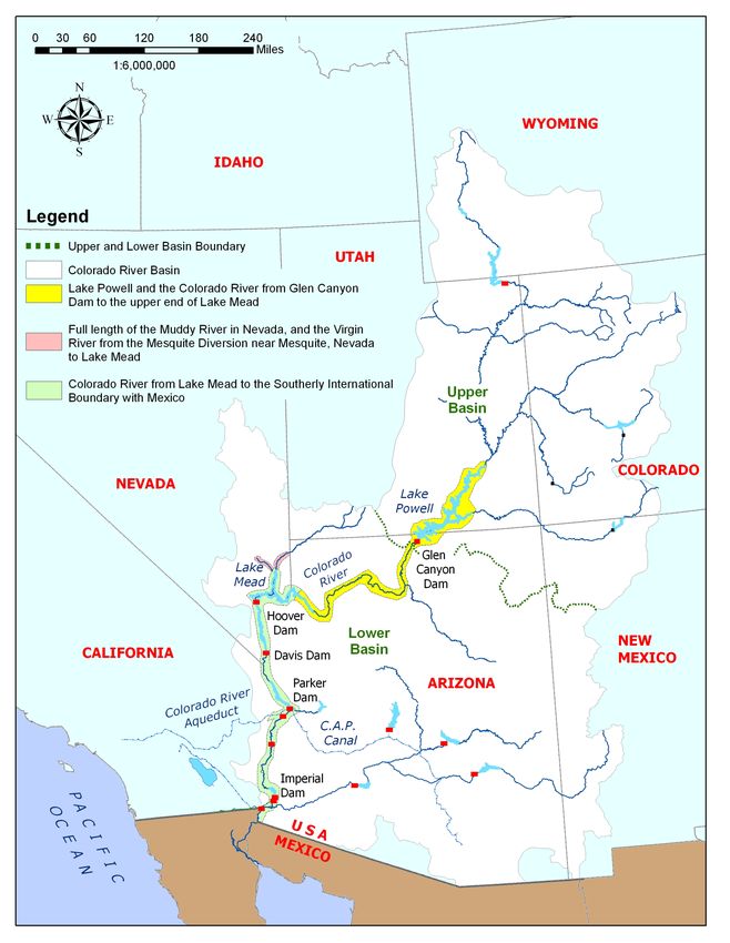
Action Area
The geographic region that could be affected by the proposed action and interdependent
actions (i.e., the action area) is shown in Figure 1 and includes the following areas:
• The Colorado River and its floodplain from the high-pool elevation of Lake Powell
(elevation 3,700 msl) to the high-pool elevation of Lake Mead (elevation 1,229 msl).
• The channel of the Lower Virgin River and its floodplains and the channel of the
Muddy River and its floodplains. The action area in the Lower Virgin River extends
from the Nevada/Arizona border to the confluence of Lake Mead. The action area in
the Muddy River begins south of the headwaters at Warm Springs and extends to the
confluence of Lake Mead.
• The Colorado River and its floodplain from the high-pool elevation of Lake Mead to
the southerly international boundary with Mexico.
As stated above, this biological opinion addresses the potential effects of the proposed action
for all portions of the action area except from the high-pool elevation of Lake Mead
(elevation 1,229 msl) to the southerly international boundary with Mexico. Because the
proposed action could have indirect effects to fishes in the Lake Powell-to-Lake Mead reach
of the action area, the action area also includes all streams tributary to the Colorado River in
Glen Canyon National Recreation Area and Grand Canyon National Park, as well as the
Little Colorado River (LCR) on Navajo Nation lands.
STATUS OF THE SPECIES AND CRITICAL HABITAT
Humpback chub
The humpback chub was listed as endangered on March 11, 1967 (32 FR 4001). Critical
habitat for humpback chub was designated in 1994. Seven reaches of the Colorado River
system were designated as critical habitat for humpback chub for a total river length of 379
miles in the Yampa, Green, Colorado, and Little Colorado rivers in Arizona, Colorado and
Utah. Known constituent elements include water, physical habitat, and biological
environment as required for each life stage (59 FR 13374; FWS 1994). Water includes a
quantity of sufficient quality (i.e., temperature, dissolved oxygen, lack of contaminants,
nutrients, and turbidity) that is delivered to a specific location in accordance with a
hydrologic regime that is required for the particular life stage. Physical habitat includes areas
of the Colorado River system for use in spawning, nursery, feeding, and rearing or corridors
to these areas. The biological environment includes food supply and habitats with levels of
nonnative predators and competitors that are low enough to allow for spawning, feeding, and
rearing.
The humpback chub is a medium-sized freshwater fish (to about 20 inches) of the minnow
family, Cyprinidae. The adults have a pronounced dorsal hump, a narrow flattened head, a
fleshy snout with an inferior-subterminal mouth, and small eyes. It has silvery sides with a13 brown or olive-colored back. The humpback chub is endemic to the Colorado River Basin and is part of a native fish fauna traced to the Miocene epoch in fossil records (Miller 1955, Minckley et al. 1986). Humpback chub remains have been dated to about 4000 B.C., but the fish was not described as a species until the 1940s (Miller 1946), presumably because of its restricted distribution in remote whitewater canyons (FWS 1990). Because of this, its original distribution is not known. Populations of this species occur in the Little Colorado and Colorado rivers in the Grand Canyon, Black Rocks area of the Colorado River, Westwater Canyon, Cataract Canyon, Desolation/Grey Canyon, and Yampa Canyon (Valdez and Clemmer 1982, FWS 1990, 2002a). The largest population in the upper basin is in Westwater Canyon, with an estimated population size of about 2,400 adult fish (age 4+;≥ 200 mm total length); humpback chub are currently rare in the Yampa River and in Cataract Canyon (Finney et al. 2004, McAda 2004, Jackson 2004a, 2004b, and Utah Division of Wildlife Resources 2004). In Grand Canyon, adult population estimates based on the age-structured mark recapture (ASMR) model ranged from 10,000-11,000 in 1989 to 3,100-4,400 in 2001 (Coggins et al. 2006). However, between 2001 and 2006, numbers of adult fish, based on newer analyses using the ASMR model, appear to have increased from about 4,500-5,700 in 2001 to an estimated 5,300-6,700 in 2006 (USGS 2007). Adult humpback chub may be found in deep, swift waters with varying depths. Backwaters, eddies, and runs have been reported as common capture locations for young-of-year humpback chub (Valdez and Clemmer 1982). These data indicate that in Black Rocks and Westwater Canyon, young utilize shallow areas. Habitat suitability index curves developed by Valdez et al. (1990) indicate young-of-year prefer average depths of 2.1 feet with a maximum of 5.1 feet. Average velocities were reported at 0.2 feet per second. Swimming abilities of young-of-year humpback chub were determined to be significantly reduced when laboratory water temperatures were reduced from 68 to 57.2° F (Berry and Pimentel 1985). Little is known about the specific spawning requirements of the humpback chub. It is known that the fish spawn soon after the highest spring flows when water temperatures approach 68° F in the upper Colorado River basin (Kaeding et al. 1990, Karp and Tyus 1990, FWS 1990), and in the spring between March and May in the LCR when water temperatures are between 60.8° to 71.6°F. Habitats where ripe humpback chub have been collected are typically deep, swift, and turbid. As a result, spawning in the wild has not been directly observed. Gorman and Stone (1999) reported that ripe male humpback chub in the LCR aggregated in areas of complex habitat structure (i.e., matrix of large boulders and travertine masses combined with chutes, runs, and eddies, 1.6–6.6 feet deep) and were associated with deposits of clean gravel. Valdez and Ryel (1995, 1997) reported that during spring, adult humpback chub in the Colorado River in Grand Canyon primarily used large recirculating eddies, occupying areas of low velocity adjacent to high-velocity currents that deliver food items. They also reported that adults congregated at tributary mouths and flooded side canyons during high flows. Robinson et al. (1998) and Stone and Gorman (2005) found that larval and juvenile humpback chub utilize nearshore habitats and quantified numbers of humpback chub that are transported by LCR flows into the mainstem. Robinson et al. (1998) and Stone and Gorman
14

(2005) also suggested that daily fluctuations in the mainstem river may reduce the quality of
nearshore habitat for juvenile humpback chub, which may be particularly important during
the monsoon period (July to November) when summer storms cause floods in the LCR,
displacing large numbers of juvenile humpback chub into the mainstem (GCMRC unpubl.
data). Pre-dam annual peak Colorado River flows (April–July) ponded canyon-bound
tributary mouths (Howard and Dolan 1981), including the LCR. Robinson et al. (1998)
theorized that because ponding probably retained drifting larvae or slowed their passage, it
probably allowed greater time for development in a warm, low-velocity environment.
Without this ponding effect, presumably more larval and juvenile humpback chub are likely
transported into a now-harsher mainstem river while still at a size that is more vulnerable to
thermal shock and predation.

Humpback chub are typically omnivores with a diet consisting of insects, crustaceans, plants,
seeds, and occasionally small fish and reptiles. They appear to be opportunistic feeders,
capable of switching diet according to available food sources, and ingesting food items from
the water’s surface, mid-water, and river bottom. Valdez and Ryel (1995) examined diets of
humpback chub in Grand Canyon. Guts of 158 adults from the mainstem Colorado River,
flushed with a nonlethal stomach pump, had 14 invertebrate taxa and nine terrestrial taxa,
including simuliids (blackflies, in 77.8 percent of fish), chironomids (midges, 57.6 percent),
Gammarus (freshwater shrimp, 50.6 percent), Cladophora (green alga, 23.4 percent),
Hymenoptera (wasps, 20.9 percent), and cladocerans (water fleas, 19.6 percent). Seeds and
human food remains were found in eight (5.1 percent) and seven (4.4 percent) fish
respectively.

The decline of the humpback chub throughout its range is due primarily to habitat
modification due to streamflow regulation and predation and competition by nonnative fish
species (FWS 2002a). Streamflow regulation, in general, eliminates flow and temperature
needs for spawning and successful recruitment, which is exacerbated by predation and
competition from nonnative fishes. In Grand Canyon, brown trout (Salmo trutta), channel
catfish (Ictalurus punctatus), black bullhead (Ameiurus melas), and rainbow trout
(Oncorhychus mykiss) have been identified as principal predators of juvenile humpback
chub, with consumption estimates that suggest loss of complete year classes to predation
(Marsh and Douglas 1997, Valdez and Ryel 1997). Valdez and Ryel (1997) also suggested
that common carp (Cyprinus carpio) could be a significant predator of incubating humpback
chub eggs in the LCR. In the upper basin, channel catfish have been identified as the
principal predator of humpback chub in Desolation/Gray Canyons (Chart and Lentsch 2000),
and in Yampa Canyon (FWS 2002a). Smallmouth bass (Micropterus dolomieu) have also
become a significant predator in the Yampa River (T. Chart, FWS, pers. comm., 2007).
Parasitism, hybridization with other native Gila, and pesticides and pollutants are also factors
in the decline (FWS 2002a).

Many section 7 consultations have occurred on the humpback chub in both the upper and
lower basins of the Colorado River. Activities that continue to adversely affect the
humpback chub and its habitat throughout its range include dam operations, recreation, land
uses that impact water quality, and the presence of nonnative species. However many
surveys, and numerous projects to improve the species status, such as translocation and
15

nonnative species removal, have occurred for the species. Although the recovery goals for
humpback chub that amend and supplement the 1990 Recovery Plan (FWS 2002a) are
currently in revision, the document provides a complete discussion of the taxonomy,
distribution, and life history of the species.

Kanab ambersnail

The Kanab ambersnail was listed as an endangered species without critical habitat in 1992
(57 FR 13657). The species is undergoing a 5-year review by the FWS, including a genetic
evaluation of the species relatedness to other Oxyloma.

The genus Oxyloma has a broad distribution (North America, Europe and South Africa) with
two species recognized in the southwestern United States: O. retusa in New Mexico and O.
haydeni in Arizona and Utah. Within O. haydeni there are two subspecies, the Niobrara
ambersnail (O. h. haydeni) and the Kanab ambersnail (O. h. kanabensis), both of which are
found in Arizona and Utah. Populations of Kanab ambersnail presently occur from only four
springs: two near Three Lakes, near Kanab, Utah, and two in Grand Canyon National Park,
Arizona, one at a spring and hanging garden at RM 31.5 known as Vaseys Paradise, and a
translocated population at Upper Elves Chasm, at RM 116.6 (Sorensen 2005). A third
population in the Kanab area, near “the Greens,” a seep-fed marsh, was believed to be lost
due to dewatering in the last decade (FWS 1995a). The remaining populations near Three
Lakes are located on private lands at several small spring-fed ponds on cattail (Typha sp.).

The population at Elves Chasm was created via translocation of snails from Vaseys Paradise.
In 1998, the Arizona Game and Fish Department (AGFD) in coordination with the NPS,
translocated snails to three sites in Grand Canyon National Park: Elves Chasm, Keyhole
Spring, and Deer Creek. Although Elves Chasm was the only successful translocation, it has
shown success including recruitment, overwinter survival, and increased density of snails
(Sorensen and Nelson 2002). Recently Kanab ambersnail has become rare at Elves Chasm,
although the species remains abundant at Vaseys Paradise (J. Sorensen, AGFD, pers comm.,
2007).

The Kanab Ambersnail is dependent upon wetland vegetation for food and shelter, living in
association with wetland plants including watercress (Nasturtium), monkeyflower (Mimulus),
cattails, sedges (Carex spp.), and rushes (Juncus spp.). Stevens et al. (1997) found that
Kanab ambersnail populations in the Grand Canyon region occur in areas where water
sources originate from limestone or sandstone geologic strata. Kanab ambersnail at Vaseys
Paradise predominantly use crimson monkeyflower and water-cress for food and shelter
(Stevens et al. 1997a). The other Grand Canyon population, Upper Elves Chasm, is located
above the 100,000 cfs stage of the river and is characterized by predominately crimson
monkeyflower and maidenhair fern (Adiantum capillus-veneris), with lesser amounts of
sedges, rushes, cattails, water-cress, helleborine orchids (Epipactis gigantea) and grasses
(Poaceae)(Sorensen and Nelson 2002). From evidence collected in laboratory conditions,
microclimatic conditions such as higher humidity and lower air temperatures relative to the
surrounding environments and high vegetative cover may be important habitat features
related to Kanab ambersnail survival (Sorenson and Nelson 2002).
16

Kanab ambersnails are hermaphroditic and capable of self-fertilization (Pilsbry 1948, Clarke
1991). Mature Kanab ambersnail mate and reproduce during the summer months (July and
August), and deposit clear, gelatinous egg masses on undersides of moist to wet live stems,
on the roots of water-cress, and on dead stems of crimson monkey-flower (Stevens et al.
1997a). In some years with relatively warm winters, more than one reproductive period can
occur. Adult mortality increases in late summer and autumn leaving the overwintering
population dominated by subadults. Young snails enter dormancy in October-November and
typically become active again in March-April. Over-winter mortality of Kanab ambersnail
can range between 25 and 80 percent (Stevens et al. 1997a & 1997b). Kanab ambersnail feed
on plant tissue, bacteria, fungi and algae that are scraped off of dead plant tissue by means of
a radula or rasp tongue. Stevens et al. (1997b) observed KAS feeding largely on crimson
monkey-flower and water-cress.

Ongoing taxonomic studies indicate that although the population at Vaseys Paradise appears
to be unique, the taxon itself may not be valid. Mitochondiral and cellular (microsatelite)
DNA analysis indicates that the Kanab ambersnail may be part of a larger taxonomic group.
However, these results are preliminary; the study is ongoing and should be completed in
2008 (M. Carver, University of Arizona, pers. comm. 2007).

Numerous biological opinions have been completed on the Kanab ambersnail. Most of these
have been on the Grand Canyon population addressing the effects of experimental flows
from Glen Canyon Dam. Activities that continue to adversely affect the Kanab ambersnail
include water use, dam operations, and recreation-related trampling. However, many
surveys, several research projects, and habitat salvage projects have occurred for the species.
Stochastic events also continue to affect the distribution, quality, and extent of Kanab
ambersnail habitat, predominantly drought.

Southwestern Willow Flycatcher

The southwestern willow flycatcher is a small grayish-green passerine bird (Family
Tyrannidae) measuring approximately 5.75 inches. The song is a sneezy “fitz-bew” or a “fit-
a-bew”, the call is a repeated “whitt.” It is one of four currently recognized willow flycatcher
subspecies (Phillips 1948, Unitt 1987, Browning 1993). It is a neotropical migrant that
breeds in the southwestern United States and migrates to Mexico, Central America, and
possibly northern South America during the non-breeding season (Phillips 1948, Stiles and
Skutch 1989, Peterson 1990, Ridgely and Tudor 1994, Howell and Webb 1995). The
historical breeding range of the southwestern willow flycatcher included southern California,
Arizona, New Mexico, western Texas, southwestern Colorado, southern Utah, extreme
southern Nevada, and extreme northwestern Mexico (Sonora and Baja) (Unitt 1987).

The southwestern willow flycatcher was listed as endangered without critical habitat on
February 27, 1995 (60 FR 10694; FWS 1995b). Critical habitat was later designated on July
22, 1997 (62 FR 39129; FWS 1997). On October 19, 2005, the FWS re-designated critical
habitat for the southwestern willow flycatcher (70 FR 60886; FWS 2005b). A total of 737
river miles across southern California, Arizona, New Mexico, southern Nevada, and southern
17

Utah were included in the final designation. The lateral extent of critical habitat includes
areas within the 100-year floodplain. The primary constituent elements of critical habitat are
based on riparian plant species, structure and quality of habitat and insects for prey. A final
recovery plan for the southwestern willow flycatcher was completed in 2002 (FWS 2002b).

Southwestern willow flycatchers primarily use Geyer willow (Salix geyeriana), coyote
willow (Salix exigua), Goodding’s willow (Salix gooddingii), boxelder (Acer negundo),
saltcedar (Tamarix sp.), Russian olive (Elaeagnus angustifolia), and live oak (Quercus
agrifolia) for nesting. Other plant species less commonly used for nesting include:
buttonbush (Cephalanthus sp.), black twinberry (Lonicera involucrata), cottonwood
(Populus spp.), white alder (Alnus rhombifolia), blackberry (Rubus ursinus), and stinging
nettle (Urtica spp.). Based on the diversity of plant species composition and complexity of
habitat structure, four basic habitat types can be described for the southwestern willow
flycatcher: monotypic willow, monotypic exotic, native broadleaf dominated, and mixed
native/exotic (Sogge et al.1997).

Open water, cienegas, marshy seeps, or saturated soil are typically in the vicinity of
flycatcher territories and nests; flycatchers sometimes nest in areas where nesting substrates
were in standing water (Maynard 1995, Sferra et al. 1995, 1997). However, hydrological
conditions at a particular site can vary remarkably in the arid Southwest within a season and
among years. The flycatcher’s habitat is dynamic and can change rapidly.

Throughout its range the southwestern willow flycatcher arrives on breeding grounds in late
April and May (Sogge and Tibbitts 1992, Sogge et al. 1993, Sogge and Tibbitts 1994,
Muiznieks et al. 1994, Maynard 1995, Sferra et al. 1995, 1997). Nesting begins in late May
and early June and young fledge from late June through mid-August (Willard 1912, Ligon
1961, Brown 1988a, 1988b, Whitfield 1990, Sogge and Tibbitts 1992, Sogge et al. 1993,
Muiznieks et al. 1994, Whitfield 1994, Maynard 1995). Typically one brood is raised per
year, but birds have been documented raising two broods during one season and renesting
after a failure (Whitfield 1990, Sogge and Tibbitts 1992, Sogge et al. 1993, Sogge and
Tibbitts 1994, Muiznieks et al. 1994, Whitfield 1994, Whitfield and Strong 1995).

Unitt (1987) documented the loss of more than 70 southwestern willow flycatcher breeding
locations rangewide (peripheral and core drainages within its range), estimating the
rangewide population at 500 to 1000 pairs. Since 1993, a total of 133 sites once known to
have breeding flycatchers are no longer presently occupied by nesting birds (Durst et al.
2006). There are currently 275 known southwestern willow flycatcher breeding sites in
California, Nevada, Arizona, Utah, New Mexico, and Colorado (all sites from 1993 to 2005
where a resident flycatcher has been detected) holding an estimated 1,214 territories (Durst et
al. 2006). While numbers have significantly increased in Arizona (145 to 495 territories
from 1996 to 2005) (English et al. 2006), overall distribution of flycatchers throughout the
state has not changed significantly. Currently, population stability in Arizona is believed to
be largely dependent on the presence of two large populations (Roosevelt Lake and the San
Pedro/Gila River confluence). Therefore, the result of catastrophic events or losses of
significant populations either in size or location could greatly change the status and survival
18

of the bird. Conversely, expansion into new habitats or discovery of other populations would
improve the known stability and status of the flycatcher.

The decline of the southwestern willow flycatcher has been attributed primarily to loss,
modification, and fragmentation of riparian breeding habitat, along with a host of other
factors including loss of wintering habitat and brood parasitism by the brown-headed
cowbird (Molothrus ater) (Sogge et al. 1997, McCarthey et al. 1998). Habitat loss and
degradation are caused by a variety of factors, including urban, recreational, and agricultural
development, water diversion and groundwater pumping, channelization, dams, and livestock
grazing. Fire is an increasing threat to willow flycatcher habitat (Paxton et al. 1996),
especially in monotypic saltcedar vegetation (DeLoach 1991) and where water diversions
and/or groundwater pumping desiccates riparian vegetation (Sogge et al. 1997). Willow
flycatcher nests are parasitized by brown-headed cowbirds, which lay their eggs in the host’s
nest. Feeding sites for cowbirds are enhanced by the presence of livestock and range
improvements such as waters and corrals, agriculture, urban areas, golf courses, bird feeders,
and trash areas. When these feeding areas are in close proximity to flycatcher breeding
habitat, especially coupled with habitat fragmentation, cowbird parasitism of flycatcher nests
may increase (Hanna 1928, Mayfield 1977a, 1977b).

Since listing in 1995, approximately 150 Federal agency actions have undergone formal
section 7 consultation throughout the flycatcher’s range. Many activities continue to
adversely affect the distribution and extent of all stages of flycatcher habitat throughout its
range (development, urbanization, improper grazing, recreation, native and nonnative habitat
removal, dam operations, river crossings, ground and surface water extraction, etc.);
however, many surveys, riparian protection projects, and land acquisitions have occurred for
the species. Stochastic events also continue to change the distribution, quality, and extent of
flycatcher habitat.

ENVIRONMENTAL BASELINE

The environmental baseline includes past and present impacts of all Federal, State, or private
actions in the action area, the anticipated impacts of all proposed Federal actions in the action
area that have undergone formal or early section 7 consultation, and the impact of State and
private actions which are contemporaneous with the consultation process. The
environmental baseline defines the current status of the species and its habitat in the action
area to provide a platform to assess the effects of the action now under consultation.

Status of the species and critical habitat within the action area

Humpback Chub and its Critical Habitat

Humpback chub in the lower Colorado River basin (below Glen Canyon Dam) occurs in the
Colorado River in Marble and Grand Canyons, and in the lower 10 miles of the LCR,
constituting the Grand Canyon population, which also represents the lower basin recovery
unit (FWS 2002a). Critical habitat in Arizona includes most of the habitat now used by the
Grand Canyon population of humpback chub. Designated reaches are the lower 8 miles of
19

the LCR and from RM 34 (Nautiloid Canyon) to RM 208 (Granite Park) along the Colorado
River. This represents approximately 28 percent of the historical habitat for the species, and
48 percent of critical habitat. The dominant factors affecting critical habitat in Grand
Canyon are habitat alteration due to Glen Canyon Dam and the presence of nonnative fish
that prey on and compete with native fishes. The known constituent elements are present and
functional throughout designated critical habitat in the action area to some degree, primarily
in the LCR; the mainstem Colorado River may provide all constituent elements, but at times
appears too cold or has too many nonnative fishes to fully function.

The Grand Canyon population consists primarily of adults residing in and near the LCR, with
much smaller aggregations of the species scattered throughout approximately 180 river miles
of the Colorado River. Valdez and Ryel (1995) identified nine mainstem aggregations of
humpback chub in Grand Canyon: 30 mile (RM 29.8 to 31.3); LCR Inflow (RM 57.0-65.4);
Lava to Hance (RM 65.7-76.3); Bright Angel Creek Inflow (RM 83.8-93.2); Shinumo Creek
Inflow (RM 108.1-108.6); Stephen Aisle (RM 114.9-120.1); Middle Granite Gorge (RM
126.1-129.0); Havasu Creek Inflow (RM 155.8-156.7); and Pumpkin Spring (RM 212.5-
213.2). The contribution of mainstem aggregations, other than the LCR Inflow aggregation,
to the overall Grand Canyon population are not known, but is thought to be small.

The relationship between fish in the LCR inflow area and the LCR itself is still uncertain;
Douglas and Marsh (1996) suggested that two populations exist: one resident population in
the LCR and one that migrates between the LCR and LCR inflow reach. However, Gorman
and Stone (1999) suggested that the majority of adult humpback chub larger than 300 mm
total length (TL) live in the LCR inflow reach except during the spawning migration.
Movement between the LCR, the LCR inflow, and other mainstem aggregations has been
documented, although most movement is between the LCR and the LCR inflow, with less
movement between the other mainstem aggregations (Paukert et al. 1996).

The humpback chub was likely historically distributed throughout Grand Canyon, with local
concentrations, although there is little information to gauge historical abundance. Valdez and
Ryel (1995) estimate that the range of humpback chub in Grand Canyon has declined by
about 61 miles or 24 percent since Glen Canyon Dam was completed, based on historical
captures of humpback chub from the dam site to Separation Canyon (RM 241), and current
capture locations from South Canyon (RM 30.0) to Granite Spring Canyon (221.0).

Coggins et al. (2006) summarized information on abundance and analyzed monitoring data
collected since the late 1980s and found that data from all sources using various methods
consistently indicated that the adult population had declined since monitoring began. Adult
population estimates for an age-structured Jolly–Seber model ranged from about 14,500 in
1989 to about 2,400 in 2001; a similar model, the ASMR, estimated population size from
10,000-11,000 adults in 1989 to 3,100-4,400 in 2001 (Coggins et al. 2006). The main cause
for the decline appears to be a decline in recruitment such that adult mortality exceeds
recruitment. ASMR results suggest a peak in recruitment in the late 1970s to early 1980s of
13,500-18,500 age-2 fish. After that peak, an overall decline was evident to the early 1990s,
when annual recruitment stabilized at about 2,000 age-2 fish (Coggins et al. 2006). Recent
ASMR analyses indicate that the Grand Canyon population appears to have increased from
You can also read