TRANSBORDER COOPERATION OF SHARED RIVER BASINS UNDER THE ALBUFEIRA CONVENTION - SCOPING REPORT
←
→
Page content transcription
If your browser does not render page correctly, please read the page content below
TRANSBORDER COOPERATION OF SHARED RIVER BASINS
       UNDER THE ALBUFEIRA CONVENTION

                   SCOPING REPORT
                    Author: Henk Zingstra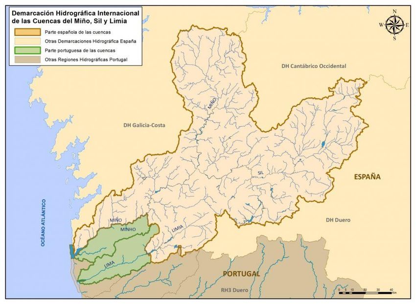
TRANSBORDER COOPERATION OF SHARED RIVER BASINS

       UNDER THE ALBUFEIRA CONVENTION

                       Henk Zingstra
        Wetlands International – European Association

                                     (Final)

        This report was supported by the European
        Commission through LIFE NGO funding. This
        publication reflects only the author’s view. The
        contents of this report can in no way be taken to
        reflect the views of the European Commission.

                                     2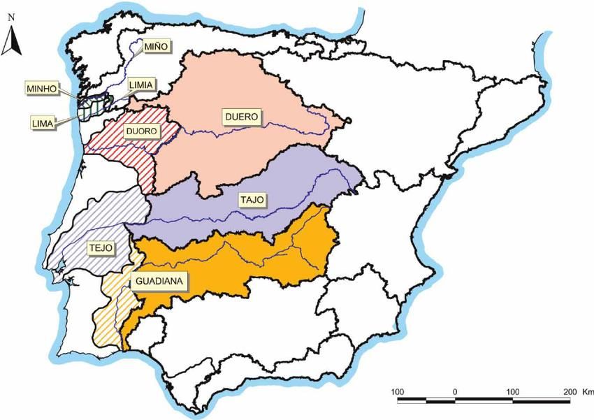
CONTENT

Introduction .................................................................................................................... 5
Summary ........................................................................................................................ 6
1      The Albufeira Convention...................................................................................... 7
2.     Brief Introduction Into the River Basins .............................................................. 10
        2.1 Guadiana River Basin .................................................................................. 10
        2.2 The Tagus River ........................................................................................... 13
        2.3 Douro River Basin ....................................................................................... 15
        2.4 The Minho/Lima River Basin ...................................................................... 16
3.     Towards a Transboundary River Basin Approach ............................................... 19
        3.1 River Basin Approach .................................................................................. 19
        3.2 Integrated Water Resources Management .................................................... 19
        3.3 The EU Water Framework Directive ........................................................... 21
        3.4 Ecological flow ............................................................................................ 22
        3.5 The role of Wetlands .................................................................................... 24
4      International Agreements in Water Resources Management ............................... 25
        4.1 Convention on the Protection and Use of Transboundary Watercourses and
            International Lakes....................................................................................... 25
        4.2 Ramsar Convention ...................................................................................... 26
        4.3 The UNE Freshwater Strategy 2017 – 2021 ............................................... 27
        4.3 OECD Water Governance Principles ........................................................... 27
        4.4 Global Water Partnership ............................................................................. 28
5      Rhine and Sava .................................................................................................... 30
        5.1 Introduction. ................................................................................................. 30
        5.2 International Commission for the Protection of the Rhine .......................... 30
             5.2.1 Brief history .......................................................................................... 30
             5.2.2 Aims of the Convention ........................................................................ 31
             5.2.3 Achievements ........................................................................................ 32
        5.3 The International Sava Basin Commission................................................... 33
             5.3.1 Brief history of the ISBC ...................................................................... 33
             5.3.2 Aims of the Sava Basin Commission .................................................... 34
             5.3.5 Achievements ........................................................................................ 35
        5.4 Conclusions .................................................................................................. 36

                                                          3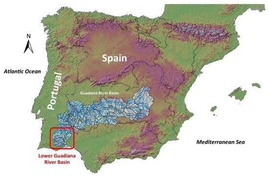
6      Interviews ............................................................................................................. 38
7      Conclusions and Recommendations .................................................................... 43
        7.1 Conclusions .................................................................................................. 43
        7.2 Recommendations ........................................................................................ 44
Annex 1 ........................................................................................................................ 47
Workshop on Cross-border water management between Spain and Portugal ............ 47
Annex 2 ........................................................................................................................ 50
Ramsar Sites in Portugal and Spain connected to one of the shared river basins ........ 50
Footnotes and references.............................................................................................. 52

                                                          4
INTRODUCTION

         The reason for evaluating the cooperation between Spain and Portugal in managing
their transboundary rivers is because citizens and environmental groups are concerned about
the ongoing deterioration of the ecological and environmental qualities of the rivers and
dissatisfied with the actions taken to halt this trend. They feel that the Albufeira Convention
in its current form is not helping to address the problems and are wondering whether to break
open the Convention to negotiate a new one or whether other arrangements can be put in
place to address the ecological and environmental problems of the shared rivers.
         A group of environmental NGO’s headed by GEOTA cooperate in a project titled
“Reviving the Douro Basin” . The planned outcomes of this project include: Legal actions &
Optimizing legal compliance, Mobilizing public pressure / campaigning, Improving
understanding of importance of basin ecology, Protection / Restoration / Maintenance ,
Influencing policy life cycles and the legal framework and Promoting Integrated River Basin
Management / Integrated Water Resources Management.
         As part of this last outcome a scoping study is proposed for the establishment of a
bilateral International River Basin Management Plan for the Douro River. The scoping study
would be the bases for starting a process towards improved bilateral cooperation on the
Douro River. In the course of the project is was decided not to limit the project to the Douro
River but instead to make an assessment of the cooperation between Spain and Portugal for
all four major cross border rivers and present recommendations for improvement.
         The assessment would identify what works and what not, analyse whether the
Albufeira Convention is the right tool to improve transborder cooperation and present
recommendations for steps to arrive at genuine integrated river basin management taking the
basin as one unseparated body as starting point.
         An important aspect of the project would be to bring civil organisations together and
increase their knowledge on Integrated Water Resources Management and River Basin
Management to empower them in promoting sustainable river basin management.
         Parallel to the scoping study a screening of existing legislation in Portugal directly or
indirectly related with water management and river protection is being carried out by
CEDOUA to identify potential legal conflicts and pinpoint at legislative holes that jeopardize
river protection.

                                                5
SUMMARY

        Next to severe droughts in 1993-1995 an important impetus for starting the
negotiations on the new Albufeira Convention was the Portuguese wish to assure stream
flows for the Alqueva dam, located in the Guadiana River. It is therefor no surprise that the
Albufeira Convention is very much geared towards cooperation on water quantity in addition
to water quality aspects but less so on the ecological aspects of river basin management.
        This report will start with a brief introduction to all four shared river basins before
clarifying some basic principles of Integrated Water Resources Management and the River
Basin Approach that both lay at the foundation of the European Water Framework Directive.
        The directive requires that the MS coordinate all programmes of measures for the
whole of the river basin district in order to achieve the objectives of the WFD, but each
Member State can chose the appropriate administrative arrangements, including the
identification of the competent authority for international river basin districts.
        An overview of international treaties and conventions relevant for cross border river
basin management will be presented. This overview shows that both Portugal and Spain are
party to a number of conventions and treaties that provide legal support for river basin
management and the establishment of joint bodies for shared river basins.
        Two examples of cross border cooperation on shared river basins will be presented
namely for the River Rhine and the River Sava to show how transborder river basin
management is organised for these two international rivers. It shows that ecological
restoration combined with flood protection measures and measures to improve the water
quality are important elements of managing the River Rhine. Participating countries have
developed a shared vision for the future of the Rhine which they take as a starting point for
their national River Basin District Plans. Cooperation between the Sava Basin countries on
the contrary is more focused on navigation and early warning systems. Environmental NGO’s
in the Sava Basin are pushing ecological restoration and nature based solutions to flooding
issues but without much success. Environmental NGO’s in the Rhine Basin are closely
cooperating under the Green Rhine Corridor Initiative (https://greenrhinecorridor.org/).
        The findings from the interviews with a number of key stakeholders in management
of the shared river basins show that overall the Albufeira Convention is seen as a useful and
successful tool in supporting cross border cooperation on the shared river basins. But it is also
recognized that there is room for improvement especially when it comes to harmonized River
Basin Management Plans. Issues where the cooperation should be improved include securing
sufficient and consistent water flows including the definition of what ecological flows means
and establishing ecological flows, the use of climate models and climate impact predictions,
monitoring and data exchange, assessment of the status of water bodies and the design of the
Programme of Measures. And for environmental NGO’s an important impediment is the is a
lack of involvement of civil society in the decision taking procedures in the Albufeira
Convention.
        The final chapter will present conclusions and recommendations.

                                               6
1 THE ALBUFEIRA CONVENTION
The first water treaties between Portugal and Spain date back to the 19th century and
several treaties were later signed in the 1920s and 1960s. The latest, from 1998, is the
Albufeira Convention. This convention seeks to balance environmental protection with
sustainable use of water resources within the framework of International and EU Law. In
2008 a seasonal flow regime for the Douro, Tagus and Guadiana was defined (as a revision of
the convention), which includes minimum flows for different times of the year.
A severe drought in the peninsula in 1993-95 provided an impetus to negotiate and at
the same time a hardening of the positions of the two states prior to the signing of the 1998
Albufeira Convention. Intense media coverage of the Spanish plans for the construction of
power plants in Portugal fuelled the popular image of Spain 'stealing' Portugal’s water. The
Portuguese priority in the Convention was to assure stream flows for the Alqueva dam,
located in the Guadiana River. Another impetus for negotiating and signing the Convention
was the growing water demand in Spain that had reduced the amount of water flowing into
Portugal.
The Convention covers four trans border river basins: Minho and Lima, Douro, Tejo
and Guadiana. See the map below.
River Basin Surface in km2 Surface in km2 Surface in km2 Percentage Percentage
Spain Portugal Total Spain Portugal
Minho 16230 850 17080 95% 5%
Lima 1300 1180 2480 52% 48%
Duero/Douro 79000 18600 97600 81% 19%
Tagus 55800 24800 80600 69% 31%
Guadiana 55300 11599 66800 83% 17%
Leonardo COSTA, J. C. (2008). Shaping a new Luso-Spanish Convention . Porto: Faculdade de Economia e
Gestão, Universidade Católica Portuguesai.
7Having sufficient water for the Alqueva dam in the Guadiana river has always been an
important issue for Portugal within the implementation of the Albufeira Convention.
One of the primary reasons that Portugal refused actual joint management of the
shared rivers was to protect its authority to manage Alqueva. Portuguese negotiators argued
that the project would be beneficial to Spain, as Spanish irrigators would potentially receive
water from Alqueva. Spain accepted Alqueva in 1996, which has been interpreted as "an act
of generosity" designed to improve bilateral relations and signal good faith in the
negotiations. However, a member of the Spanish negotiating team believes that giving up
"the only serious card we had to play" early on made it harder to achieve Spanish goals in the
talks (Bukowski, Jeanie J.)ii
As can be concluded from the above table the vast majority and the catchments of the
rivers is located in Spain with an exception for the Lima River where Spain and Portugal
have more or less an equal share of the catchment.
The Abufeira Convention deals with issues such as exchange of information,
information of the public, consultation on transboundary impacts, evaluation of
transboundary impacts, pollution control and prevention, water uses, water streams, droughts
and resource scarcity, assignment of rights, dispute resolution, etc.
Under the Convention an International Technical Commission has been established
called the Commission for the Application and Development of the Convention (CADC)
composed by delegations nominated by each Party. The CADC discusses and reviews
information related to hydrological data, new water uses, transboundary environmental
impacts etc and is also responsible for making proposals to the Conference of Parties, the
governing body of the Convention.
The main issue regulated by the Convention is the issue of stream flow allocation but
this issue is part of the so called “non-significant harm” . Except for the Lima River, the
Convention established annual guaranteed stream flows to Portugal in normal years. It is
however argued that from an environmental point of view the guaranteed stream flows had
been set too low.
It was agreed that Spain would discharge only one third of the water that flowed into
Portugal in recent decades before the signing of the Convention. And this applies only to
years with “normal rainfall”. In exceptionally dry years, Spain is bound only by the “Non-
significant harm” rule meaning that the discharge can even be lower than one third. Only for
the Guadiana River, the definition of a normal year depends also on the volume of water held
back by Spain behind its dams on this river. By transferring water from northern basins to the
Guadiana River Basin, Spain reduces the number of exceptional dry years in this river. The
“non-significant harm” rule was expected to implicate that Spain would supply to Portugal at
least the ecologically stream flows in dry years, once the CADC established them.
There are no agreed definitions and amounts of discharge for ecological flow of the
transboundary rivers defined either by the CADC or included in the River Basin Management
Plans that either Spain or Portugal have sent for review to the European Commission. The
lack of a clear definition of ecological flow and the lack of translation of this definition in
ecologically defined water discharge amounts and frequencies is a cause for further
degradation of the ecological quality of the rivers.
The National Water Plan for Portugal proposes ecological stream flows for the shared
rivers but these proposals have not been adopted by the CADC and are also not included in
the RBMPs. These proposed annual ecological flows are on an average higher than the
guaranteed river flows laid down in the Albufeira Convention.
8River Basin Annual Stream Flow ( hm3
Ecological Ecological Ecological
Average Guaranteed Flow Flow Flow
Average Year Very Dry Year Very Wet Year
Minho 4970 3700 2627 1421 4449
Lima n.a. n.a. 506 174 958
Douera/Douro 9000 3500 3081 1118 5112
Tagus 9500 2700 3032 1000 5848
Guadiana 1540 600 1766 162 4140
Leonardo COSTA, J. C. (2008). Shaping a new Luso-Spanish Convention . Porto: Faculdade de Economia e
Gestão, Universidade Católica Portuguesa.
In alignment with global concerns and European policy, Portugal developed the
National Strategy for Adaptation to Climate Change (NSACC; Resolution of the Council of
Ministers No. 24/2010), in which water resources are highlighted as a strategic sector. Hence,
the National Water Plan includes the topic “climate change”, its impacts and the risk to water
resources, as a priority for analysis. At the level of risks resulting from climate change, a
number of specific aspects for mainland Portugal should be highlighted, such as the decrease
in river flow from Spain and measures for water retention in transboundary river basins in
Spain, which can lead to the reduction of water availability in Portugaliii.
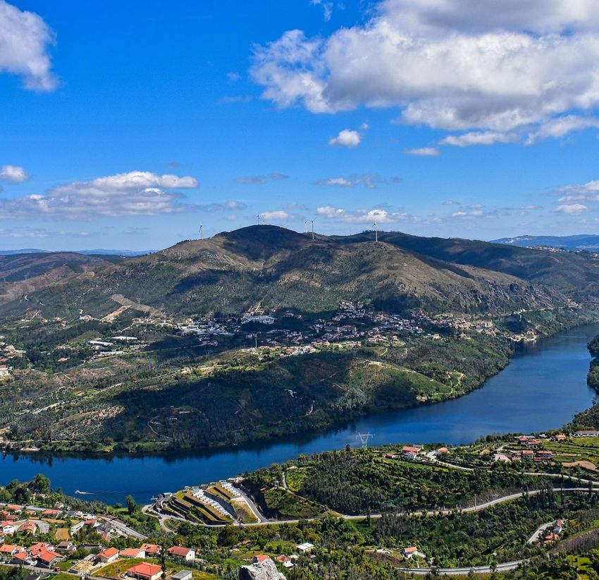
92. BRIEF INTRODUCTION INTO THE RIVER BASINS
2.1 Guadiana River Basin
Figure 1; the Guadiana River Basin iv
The Guadiana flows east to west through Spain and south through Portugal, then
forms the Spanish-Portuguese border; it flows into the Gulf of Cádiz, part of the Atlantic
Ocean, between Vila Real de Santo Antonio (Portugal) and Ayamonte (Spain). It is 818
kilometres long, of which 578 kilometres are within Spanish territory, 140 kilometres within
Portugal, while 100 kilometres (62 mi) are shared between the two nations. About 82 percent,
55,444 square kilometres of its basin is in Spain, while about 17 percent, 11,560 square
kilometres is in Portugal. (Wikipedia).
There are over 30 dams on the river basin. The following are the dams on the
Guadiana river itself:
• Alqueva Dam, the largest reservoir in Western Europe, located near Moura, in the Beja
District. (250 square kilometres and a capacity of 4,150 cubic hectometres)
• García Sola Reservoir
• Cíjara Reservoir
• El Vicario Reservoir
• Orellana Reservoir
10The mean annual precipitation is 521 mm with significant spatial and temporal
variability with a minimum precipitation of 264 mm in the low estuary and a maximum of
1397 mm in the higher altitudes of the basin. Most precipitation is falling in the period from
October to April. The mean annual temperature is 18.24 ◦C. The minimum and maximum
temperatures can reach values of −4 ◦C in winter and +44 ◦C in summer. v
The river discharges into the Gulf of Cadiz between Ayamonte and Vila Real de Santo
António, where it forms a estuary with salt marshes. Several parts of the estuary are
designated as protected areas including the Marismas and Isla Cristina in Spain and Reserva
natural do Sapal de Castro and Vila Real de Santo Antonia in Portugal. The “Sapais de Castro
Marim” in Portugal is designated as a Ramsar site. The estuary has a maximum width of 550
metres, and its depth ranges from 5 to 17 metres. The tidal height varies from 0.8 to 3.5
metres.
Despite the dry conditions in big parts of the catchment it is one of the most
biodiverse and unspoiled parts of the Iberian Peninsula. Especially the part from Badajoz
until the mouth of the river is valuable from an ecological point of view
In Spain water of the Guadiana is used for extensive irrigation schemes supported by
a large amount of dams which are both used for hydropower and irrigation purposes.
Guadiana’s waters are used for what is perhaps the most successful irrigation project in
Spain. This counts especially in the Toledo mountains in the Badajoz province where already
in the 1950-ties four major dams have each created reservoirs of more than 32 km2. Between
Badajoz city, Spain, and Monsaraz, Port., and again downstream from Pomarão, Port., the
Guadiana forms parts of the Spanish-Portuguese frontier. Navigation of small boats is
possible for only 68 km upstream to Mértola, Port while larger vessels can navigate between
Pomarão and the coastal ports of Ayamonte in Spain, and Vila Real de Santo António in
Portugal. (Timmerman, J.G., and J. Doze (2005), Transboundary river basin management
regimes: the Guadiana basin case study, Background report to Deliverable 1.3.1. of the
NeWater project, Lelystadvi)
The water quality in the Guadiana river basin is negatively impacted by mainly
sewage water discharges from agro-industrial units and agricultural land uses, both in
Portugal and Spain. There are three ecological constraints in the Guadiana river basin. The
first of them is the aquifers over-exploitation in the upper basin, which supports extensive
irrigation areas. The second ecological constraint is the non-point source pollution originated
in these areas and from industries, decommissioned mines, untreated sewages, sewage
treatment plants and landfills. The aquifer overexploitation in the upper basin is trying to be
mitigated with sustainable water use and with water transfer from the Tagus basin; however
this led to the introduction of non-native fish species in the Guadiana basin (Fornés et al.
2000). The third main ecological constraint of the Guadiana basin is the intense damming.
Initially, dams were essential to maintain water supply during the sporadic, but sometimes
long drought periods.
The first dams of this basin, and also of the Iberian Peninsula, were built by the
Romans in II A.D. These dams, Cornalvo and Proserpina, had a total capacity of 10 hm3 and
4 hm3, respectively. Later, several others were built and until 1956, when the Cijara dam
(1670 hm3) was built, the total amount of water stored in reservoirs was 115 hm3. In 1964,
this value increased to 3850 hm3, increasing slightly until 1988, when it raised again to 7540
11hm3 and to 8575 hm3 in 1990. Today, after the construction of the Alqueva dam in February
2002, 12730 hm3 of water can be stored in the 1824 dams of the Guadiana basin. The
average total flow of the Guadiana is 4400 hm3 (Dias & Ferreira 2001), however the major
86 dams retain ~150% of the average annual rainfall (UNEP 2006).vii
The amount of water drained to the Portuguese basin decreased by about 60% in the
last 30 years and the quality is rather poor. Of the total needs for irrigation and domestic
water supply, 81% and 75% are consumed and generated in Spain, respectively. The land use
is predominantly rural and irrigation accounts for 93% of water consumption in Spain. Here,
non-sustainable agriculture practises cause conflicts between environmental sustainability
and socioeconomic interests (Morais.P.)
Because of a reduction of river flow the amount of sediments transported to the coast
has been decreased significantly which has led to an decrease of the estuarine plume. This on
its turn has had a negative impact on the value of the estuary for fish species as spawning area
but also during their adult stage. This has led to an overall decrease of the number of fish
species in the estuary. (Morais.P.)
Dams have severely compromised the conservation status of endemic fishes, like
Anaecypris hispanica in the Guadiana basin. (Morais.P.) Five fish species present in the
streams of the lower Guadiana are listed in the Annex II of Habitats Directive: lamprey
(Petromyzon marinus), several cyprinidae (Rutilus alburnoides, Cobitis maroccana and A.
hispanica) and sturgeon (Acipenser sturio). As mentioned, A. hispanica is an endemism of
the Guadiana streams and is in threat of extinction.
In addition the construction of various large scale tourist resorts areas have destroyed
in largely pristine in the basin for example north of Ayamonte where a centre for 20 000
inhabitants, lodged in 6 000 houses and in 3 luxury hotels, and equipped with 7 shopping
centres, 2 golf courts and 1 marina.
Natural Reserve of Castro Marim and Vila Real de Santo António is designated as a
Ramsar site and listed under the Birds Directive and the Habitats Directive. This salt marsh
area is vital for several steppe species, such as thick-knees (Burhinus oedicnemus), calandra
lark (Melanocorypha calandra), little bustard (Tetrax tetrax), and to lesser short-toed lark
(Calandrella rufescens). This species has in this area the only nesting location in Portugal
(Leitão 2003).
The salt marsh is also a nesting place for two birds of prey, western marsh-harrier
(Circus aeruginosus) and Montagu's harrier (Circus pygargus) (Leitão 2003). The intertidal
areas adjacent to the sewage treatment plant are feeding grounds for nine limnic species,
ruddy turnstone (Arenaria interpres), dunlin (Calidris alpina), curlew sandpiper (Calidris
ferruginea), Kentish plover (Charadrius alexandrinus), common ringed plover (Charadrius
hiaticula), black-tailed godwit (Limosa limosa), grey plover (Pluvialis squatarola), little tern
(Sterna albifrons) and common redshank (Tringa tetanus); some of which are included in the
Annex I of Bird Directive (Dias 1999, Dias et al. 2003).
122.2 The Tagus River
The Tagus River is the longest river in the Iberian Peninsula. It is 1,007 km long,
716 km in Spain, 47 km along the border between Portugal and Spain and 275 km
in Portugal, where it empties into the Atlantic Ocean near Lisbon. It drains an area of 80,100
square kilometres the second largest in the Iberian Peninsula after the Douro. The Tagus is
highly utilized for most of its course. Several dams and diversions supply drinking water to
places of central Spain and Portugal, while dozens of hydroelectric stations create power.
Between the dams it follows a very constricted course, but after Almourol it enters a wide
alluvial valley, prone to flooding.
Its mouth near Lisbon is one of the largest European estuaries. This area is an
important stop over for migrating birds in the African Eurasian Flyway for water birds. The
site is designated as an SPA under the Birds Directive and as Important Birds Area by
BirdLife International and is at risk due to the planned extension of Montijo Airport. This
designation is based upon counts of 49,000 Black-tailed Godwits, 12,000 Dunlin, 6000
Avocet, 4500 Wigeon, 3300 Greylag Geese, 2000 Grey Plover and 1600 Greater Flamingos.
At present, approximately nine million people live in the basin, which contains the
capital cities of both countries. The river is highly regulated with a large number of dams,
creating a total storage capacity of nearly 14 km3, of which 80% in Spain. Installed
hydropower potential amounts to 3300 MW and the mean annual power production is
approximately 5000 GWH.
On the Portuguese territory the Tagus is free flowing for about 120 km while there are
only 2 dams. The number of dams in Spain are significantly higher and the vast majority
these dams are built to generate electric power. Given the characteristics of hydrological
variability, the volumes of water stored in reservoirs add some resilience under scarcity
periods.
13The upper Tagus cuts into limestone rocks and flows generally south-westward
through narrow, sinuous valleys with deep canyons and abundant ravines. Near Trillo
(Guadalajara province) it runs more peacefully, and just before the town of Bolarque it is held
back by the dams of Entrepeñas and Buendía, forming an artificial lake known as the Sea of
Castile, which covers an area of 132 square km. The Tagus flows mostly through semi-arid
lands, and government efforts have been dedicated to increasing land irrigation and
creating hydroelectric power in its basin.
Major efforts to harness the Tagus and its tributaries for these purposes were
undertaken from the 1960s, and by 1980 more than 60 dams had been built with a total
installed power capacity of more than 1,200,000 kilowatts. In the highlands of the Tagus
basin, coniferous trees are numerous, supporting a well-developed timber industry. About
one-third of the basin’s cultivated land is devoted to cereal farming, and everywhere are olive
trees and vineyards. In Extremadura, in western Spain, only oaks and cork trees break the
monotony of a rolling and rocky landscape.
Animal life near the river is abundant and diverse, with both European and North
African species. Fishing for royal carp, luces, and black bass is possible in the artificial lakes
of Entrepeñas and Buendía, and trout, barbels, and many other kinds of fish are caught in the
Tagus and its tributaries. There is big-game hunting in Gredos, noted for its Pyrenean, or
Spanish, ibex; in the ridges of Cuenca and Guadalajara fallow deer and chamois are found.
The climate in the basin is temperate Mediterranean, with a dry period of two months
for July and August. The average annual temperature varies between 7.4 ◦C (in areas further
north and higher altitude) and 16.9 ◦C (in estuary area), and the annual rainfall is between
2744 mm (in the northern part of the region and at an altitude of more than 1300 m) and the
524 mm (in the south, near the coast). In wet years, the annual rainfall is about 130% of the
precipitation at normal year, while in dry year, this only reaches about 70% of normal
precipitationviii
In terms of water demand, 80% of the water use is related to agricultural needs and
the 20% remaining for drinking-water production, since both Madrid and Lisbon use the
Tagus River Basin as the source of their water supply. Water abstractions for agriculture
purposes attain 1929 hm3 y −1 and urban water supply reaches 741 hm3 y −1 in the Spanish
Tagus River Basin. In Portugal, Tagus water is strongly demanded for the irrigation (~1173
hm3 y −1 ) of intensive rice paddies, orchards and arable crops area (1482 km2 ), and for
drinking water supply (~392 hm3 y −1 ). It should be pointed that Lisbon drinking water is
abstracted from a reservoir that is located in a Portuguese Tagus tributary, Zêzere River.
The availability of water is jeopardized by transferring water to the more productive
irrigated agriculture in the Segura River basin in Spain close to the Mediterranean coastline.
This area is connected to the Tagus by a water transfer channel diverting part of the Tagus
flow into the Segura basin for irrigation and food production. This poses a serious threat on
river Tagus and a very complex pressure to manage, namely during drought events.
The plan to divert water to the Segura River was initially developed in 1902. The
plan was to siphon off water from here the Tagus near Aragon and divert it to the Segura river
to irrigate farms in the arid southeast in what is known as the Tajo-Segura transfer.
Construction began in 1966 and water started flowing out of the dammed Tagus headwaters
to the Segura in 1979. However, the amount of available water was miscalculated and Spain’s
14cyclical droughts were not factored in. Today only 47% of the predicted water resources exist
and levels in the two headwater dams are down to 11% capacity, too low to allow any
transfers.
Nitrogen pollution from agriculture, livestock, and urban discharges is a key
environmental pressure on the Tagus River Basin. Nitrogen load in Spain is ≈13 times higher
than in Portugal mainly coming from livestock. Nitrogen concentration in the Spanish Tagus
River is low, but the input to Portugal is significant (14 kt y−1 ), accounting for
approximately the same amount as the total sectorial load in the Portuguese region (18 kt
y−1 ). However, reported water quality status was slightly better in Spain than in Portugal.
(Claudia. M)
2.3 Douro River Basin
The Douro is the third-longest river in the Iberian Peninsula after the Tagus and the
Ebro. Its total length is 897 kilometres of which only a few sections in Portugal are navigable
by light rivercraft. In Spain, the Douro crosses the great Castilian meseta and meanders
through five provinces of the autonomous community of Castile and
León: Soria, Burgos, Valladolid, Zamora, and Salamanca, passing through the towns
of Soria, Almazán, Aranda de Duero, Tordesillas, and Zamora. Important tributaries are
the Pisuerga, passing through Valladolid, and the Esla, which passes through Zamora. This
region is generally semi-arid plains, with wheat and in some places, especially near Aranda
de Duero, with vineyards, in the Ribera del Duero wine region. Sheep rearing is also still
important.
For 112 kilometres, the river forms part of the national border line between Spain and
Portugal, in a region of narrow canyons. It formed a historical barrier to invasions, creating a
cultural/linguistic divide. In these isolated areas, where the Aldeadavilla Dam is located and
impacting the river continuity, there are two protected areas: the International Douro Natural
Park International Douro Natural Park (on the Portuguese side) and the Arribes del Douro
Natural Park (Arribes del Duero Natural Park) on the Zamoran margin.
15The Douro fully enters Portuguese territory just after the confluence with the Agueda
River; once the Douro enters Portugal, major population centres are less frequent along the
river. Except for Porto and Vila Nova de Gaia at the river mouth, the only population centres
of any note are Foz do Tua, Pinhão and Peso da Régua. Tributaries here are small, merging
into the Douro along the canyons; the most important are Coa, Tua, Sabor, Corgo, Tavora,
Tamega and Sousa. None of these small, fast-flowing rivers is navigable.
Fifteen dams have been built on the Douro to regulate the water flow,
generate hydroelectric power, and allow navigation through locks. Beginning at the
headwaters, the first five dams are in Spain: Cuerda del Pozo, Los Rábanos, San
José, Villalcampo and Castro Dams. The next five downstream are along the Portuguese-
Spanish border; the first three are owned and operated by Portugal:
(Miranda, Picote and Bemposta Dams), while the next two belong to Spain:
(Aldeadávila and Saucelle Dams).
The last five dams in Portugal are built to support navigation; Pocinho, Valeira,
Régua, Carrapatelo, and Crestuma–Lever dams. Vessels with a maximum length of 83 metres
and width of 11.4 metres t) can pass through the five locks. The highest lock, at Carrapatelo
Dam, has a maximum lift of 35 metres. The waters of Pocinho lake reach 125 metres above
sea level. Unannounced releases of water from upstream Spanish dams occasionally causes
navigation issues in these locks.
2.4 The Minho/Lima River Basin
16Minho River, also called Miño (in Spain), has a length of about 330 km. The source of
the river lies in Spain north of Lugo in Galicia, in a place called Pedregal de Irimia. about
695 metres above sea level. After it flows underground it surfaces in the lagoon Fonmiña (in
the municipality of A Pastoriza). This lagoon located in the province of Lugo, is historically
considered as its birthplace. The Minho flows through the Galician massif and Cantabrian
Mountain range and the mountains of Leon, two of the areas of the Iberian Peninsula with the
highest precipitation, being one of the main rivers of the Atlantic slope.
After flowing through canyons first until the valley widens north of Ourense. In the last
70 km, the river defines the border between Portugal and Spain. By discharge, it is the fourth
river of the Iberian Peninsula, after the Douro, Ebro and Tagus. The Minho is used for
providing water to vineyards and farmland and is used to produce hydroelectric power.
Along its length, it has the following reservoirs: Belesar with 654 cubic
hectometres, Peares with 182 cubic hectometres, Velle with 17 cubic
hectometres, Castrelo with 60 cubic hectometres and Frieira with 44 cubic hectometres.
About 20 kilometres north of Ourense at Os Peares, the Minho, with an average
discharge of 102 m3/s, receives the waters of its main tributary, the Sil, with 184 m3/s.
Passing Ourense, there is one major dam at Frieira near the town of Ribadavia, which is
famous for its Ribeiro DOP wine (called after the name of the region). There the Minho
averages 316 m3/s of discharge. Later on, the river flows in a southwest direction until after
260 kilometres through Galicia reaching the Portuguese border near Melgaço.
From that point onward the Minho forms the border between Portugal and Spain for
about other 70 kilometres, mainly flowing west. The valley is a lush, green agricultural area
where the land is used to produce corn, potatoes, cabbage, even kiwi fruit, or just grass,
depending on the time of year, and everywhere edging the fields, rivers and gardens,
wherever there is space, the vines which produce the light, slightly sparkling “Vinho Verde”
and the Ribeiro wine, both peculiar to this area. The very best of these wines, Alvarinho in
Portuguese or Albariño in Spanish and Galician, is produced in the area
around Monção, Arbo and Melgaço.
Passing the medieval towns of Melgaço and Monção, the Minho divides the
Spanish Tui and Portuguese Valença do Minho, towns that guarded an important bridge for
road and rail. Both towns preserve fortifications and are national monuments. The Minho
reaches the Atlantic between the Galician A Guarda and the Portuguese Caminha, with an
average discharge of 420 m3/s.
All the upper course of the river where it flows its first 64 kilometres across the plateau
of Lugo (Terrachá), has been declared a Biosphere Reserve. The main tributaries are the Sil,
Neira, Avia, Barbantiño, Búbal, Arnoya rivers.
The Minho river has become one of the most important glass eel fisheries on the Iberian
Peninsula. Management of the eel stock is under the responsibility of the “Ministério da
Agricultura, do Desenvolvimento Rural e das Pescas”. Two kinds of laws are implemented in
the Spain concerning glass eels fishery. An agreement between Portuguese and Spanish
17authorities allow to fish glass eels during defined periods of time per year using a stow net.ix
Glass eels enter year-round. However, most of these entries occur between November and
April, depending on weather conditions. Eel density drops as we move farther away from the
river's mouth towards the Upper Minho, and average size rises.
The river Minho and its estuary were once considered the fish farms of Portugal, thanks
to the high biodiversity and rich variety of fish with economic value. It is designated as a Site
of Community Interest (SCI) and its estuary as a Special Protection Area (SPA), within the
Natura 2000 Network.
Pressures on the ecological quality of the River are stemming from pollution from both
point and diffuse sources, water extraction, flow management, morphological alterations,
land use, and other impacts from human activities.
The basin is heavily managed with more than 100 dams, which are mainly used for
hydropower generation. For the period 1978-2012, the repercussions of the liberalization of
the Spanish energy market in 1998 were studies (Cláudia M. d. S. Cordovil). This study
concludes that the dams in the Miño-Sil river basin had no influence on the natural river
flows over the period of interest. Moreover, despite being used so heavily for hydropower, the
liberalization of the Spanish energy market did not increase the degree of intervention in river
flows. Indeed, for three reservoirs in particular the correlation between inflow and outflow
improved. It is also clear that for the reservoirs considered, the mean water storage and
monthly inflows were lower during 1998-2012 than during 1978-1997.
From a management perspective the river Minho is looked at in combination with the
River Lima. (Portuguese Rio Lima; Galicisch Río Limia) The Lima has a length of about 108
km and its source is on the mountain Talariño, in the Spanish province Ourense. The river
flows through the city of Xinzo de Limia after which it is named. At the village of Lindoso
the river enters Portuguese territory flowing through Ponte da Barca and Ponte de Lima.
Ponte de Lima is one of the most characterful and charming towns of northern Portugal, if not
the whole of the country. The town sits on the southern banks of the slow-flowing Lima
River, and this location has been the main river crossing since the Romans constructed a
bridge in 1AD. After another 67 km on Portuguese territory the river discharges in the
Atlantic Ocean near the city of Viana do Castelo. During Roman times the river was referred
to as Lethe or Oblivio
In the upper parts the river is flowing through a gentle landscape; the highest point
with 1,154 metres is the Faro de Avión. The landscape is further characterised vineyards and
orchards, and many natural sites of great value, such as Pena Corneira and the banks of the
Miño, Arnoia and Avia. The vegetation is the result of the combined action of Nature and
human influence. The fertile soil and mild climate offer good opportunities for agriculture
and especially wine production but also for the development of a diverse flora and fauna. The
different varieties of O Ribeiro gave these lands' wines a reputation of quality that was
already recognised in times of the Roman Empire.
The River is also called Lethe- the River of Forgetfulness by the Romans who
believed that those who crossed would forever lose their memory.
183. TOWARDS A TRANSBOUNDARY RIVER BASIN APPROACH
3.1 River Basin Approach
A river is a living organism with its specific flora and fauna that depend on the
morphology of the river and the quality, quantity and dynamics of the water flow. The water
quality and flow dynamics of the river are inseparably related to the land uses in the river
basin and land use changes, morphological changes and pollution are all reflected in the
ecological quality of the river as a whole.
According to the definition used by the EU a River Basin is “the area of land from
which all surface run-off flows through a sequence of streams, rivers and, possibly, lakes into
the sea at a single river mouth, estuary or delta”.
(https://www.eea.europa.eu/themes/water/wise-help-centre/glossary-definitions/river-basin)
Land uses in the river basin steer for a significant part the discharge patterns of the
river. Large scale agricultural lands for instance with efficient drainage systems have limited
capacities to store and retain water during periods with heavy rainfall leading to quick above
surface run off and high peak discharges in rivers. The same counts when large surfaces are
paved with no chance for rainwater to percolate into the soil. Natural areas on the contrary
can retain water more easily resulting in the replenishment of groundwater, storage of water
in wetlands and other low lying areas and reduced peaks in water discharge patterns. More
obvious; pollution from either point or non-point sources in the upper reaches of the river will
have an impact on all downstream laying parts of the river.
Managing River Basins also implies managing groundwater. Although invisible
groundwater streams have a big impact on both the qualitative and quantitative aspects of
surface water. Delineating river basins will therefore need to include an analysis of
groundwater flows. Land uses in ground water recharge areas impact the quality of surface
waters in areas where ground water wells up again. In areas with high levels of nutrients or
other forms of pollution in the soil water that percolates into the ground will pick up these
pollutants and carry these to where this groundwater wells up or is pumped up.
Rivers are more and more considered as living organisms and as the main artery of a
landscape. This holistic view on rivers and river basins is further fuelled by the so called
“landscape approach’. (www.globallandscapesforum.org). The Landscape Approach
provides a broad framework that can fully integrate agriculture, the natural environment,
different livelihood systems and social interactions
3.2 Integrated Water Resources Management
The EU Water Framework Directive is based on the principles of Integrated Water
Resources Management (IWRM) as defined by the Global Water Partnership (GWP) . The
GWP defines IWRM as follows: “IWRM is a process which promotes the coordinated
development and management of water, land and related resources, in order to maximize the
19resultant economic and social welfare in an equitable manner without compromising the
sustainability of vital ecosystems.” In other words: IWRM aims at integrating the three E’s:
• Social equity: ensuring equal access for all users (particularly marginalised and
poorer user groups) to an adequate quantity and quality of water necessary to sustain
human well-being.
• Economic efficiency: bringing the greatest benefit to the greatest number of users
possible with the available financial and water resources.
• Ecological sustainability: requiring that (aquatic) ecosystems are acknowledged as
users and that adequate allocation is made to sustain their natural functioning.
IWRM is based on the understanding that water resources are an integral component of the
ecosystem, a natural resource, and a social and economic good.
There are a number of reasons that make the integrated approach a valuable and
globally accepted principle to water resources management. First of all it acknowledges the
central role water plays for nature, food production, industry and households and it
incorporates social and environmental considerations in policy making and management.
Another important characteristic of IWRM is the required involvement of stakeholders and
sectors in decision making. It helps consequently to make balanced decisions about
investments and policy directions. The promotion of IWRM is therefore an important element
of SDG 6; “clean water and sanitation”. According to the UN- SDG 6 Implementation
Tracker, the degree for the implementation of IWRM in Spain is 82 % and in Portugal 74%.
(https://www.sdg6data.org/indicator/6.5.1)
Integrated Water Resources Management is based on the so called “Dublin Principles”
agreed upon during a meeting of international water and environment experts in Dublin in
January 1992. The Dublin Statement on Water and Sustainable Development recognises the
increasing scarcity of water as a result of the different conflicting uses and overuses of water.
The declaration sets out recommendations for action at local, national and international levels
to reduce the scarcity, through the following four guiding principles:
1. Fresh water is a finite and vulnerable resource, essential to sustain life, development
and the environment
2. Water development and management should be based on a participatory approach,
involving users, planners and policy-makers at all levels
3. Women play a central part in the provision, management and safeguarding of water
4. Water has an economic value in all its competing uses and should be recognized as
an economic good.
The statement that water should be recognized as an economic good has drawn
criticism and has led to Resolution A/HRC/15/L.14,of the UN Human Rights
Council reaffirming an earlier General Assembly resolution (64/292 of 28 July 2010)
which clarifies that the human right to safe drinking water and sanitation is derived from
the right to an adequate standard of living and inextricably related to the right to the highest
attainable standard of physical and mental health, as well as the right to life and human
20dignity . This step was seen as a decisive step towards the recognition of water as universal
right.
Integrated Water Resources Management is a management approach to water
resources in general and the outcome is not only geared towards river basin management
plans. Instead the principles of IWRM can also be used to produce for instance an agricultural
water allocation plan, a river restoration plan, a drinking water strategy or a flood protection
strategy.
3.3 The EU Water Framework Directive
The European Water Framework Directive adopted in 2000 as the primary legislation
on Integrated Water Resources Management in the European Union requires integrated
management of water and land in river basins.
Basic principles of the WFD include:
• Overall aim is to achieve “good status” of all water bodies by 2027
• Good status means ecological, physical and chemical status;
• This requires a systematic analysis of all pressures on water bodies
• And the design of measures to address key pressures
• Recovery costs for water services- to promote efficient water use.
• And it requires stakeholder involvement in the planning process
The adoption of the WFD has introduced significant changes in the way water
management is applied in many countries, both at institutional level and at the way we look at
water resources and especially at rivers and river systems.
Based on the EU WFD member states are obliged to develop River Basin
Management Plans in which steps towards achieving good ecological status of water bodies
are clarified. Water bodies are river stretches or other surface waters like wetlands, lakes and
canals that share similar physical, biological and chemical attributes.
For each of these water bodies an analysis of the current physical, biological and
chemical status has to be made as well as an analysis of the pressures and impacts. This forms
the basis for the design of the Programme of Measures in which the actions that are required
to achieve good ecological status have to be described.
Based on the analysis of the current status the water body can be designated as
“heavily modified”. This label is given to water bodies if it has been modified by physical
alterations to such an extent that changes are irreversible and Good Ecological Status is no
longer achievable. In these cases, the objective is to achieve Good Ecological Potential.
In case of transborder rivers the EU-WFD requires countries to cooperate and
coordinate the management on shared river basins. The WFD does not require the
establishment of transborder river basin management organisations.
Looking at the recommendations from the European Commission upon assessing the
first cycle of RBMPs from Portugal and Spain the Commission comes to the following
conclusions and findings.
21There has been no joint implementation of Programme of Measures (PoMs) in
Portugal and Spain. In some cases, the Portuguese RBMP contains an overall measure which
relates to Spanish authorities implementing their RBMP in order for the surface and
groundwater at the border to be in good ecological status.
As the Portuguese Water Authorities report, for the new planning cycle (2015-2021),
Portugal and Spain have agreed at the December 2013 plenary session of the Commission for
the Implementation and Development of the Albufeira Convention (CADC), to enhance
communication and coordination in the various stages of the process, in particular on:
• Updating the delimitation of national and trans boundary water bodies;
• Updating the classification systems;
• Status assessment of national and trans boundary water bodies;
• Defining common environmental objectives for national and trans boundary water
bodies and related compliance timeframes;
• Harmonisation of PoMs;
• Definition of common elements for public participation processes of each RBMP
(eg. Non-technical Summary, joint public meetings, etc.);
• Coordination on pressures and impacts, water body status and initial objectives
(planned for October 2014).
Some improvements are seen in the second cycle of RBMPs but the problem remains
that there is no shared vision on the rivers basins as a whole which translates into a lack of
synchronisation of the Programme of Measures for the River Basins. This lack of
harmonisation of the PoMs can be attributed to different approaches for assessing the status
of water bodies, for not using the same climate forecasting models, for not using the same
approach for assessing pressures and impacts and for using different approaches to ecological
flow calculation.
The two countries are currently working on the 3rd cycle of RBMPs and to what
extent the problems identified above will be addressed will become clear once presented.
3.4 Ecological flow
The Water Framework Directive acknowledges the critical role of water quantity and
dynamics in supporting the quality of aquatic ecosystems and the achievement of
environmental objectives. To address the unclarities and questions concerning the definition
of ecological flows and its relation with the objectives of the EU Water Framework Directive
the Commission issued in 2015 a guidance document called “Ecological Flows and the
Implementation of the Water Framework Directive”. (Guidance Document 31) x
The Guidance document presents the following definition of “ecological flows”: “an
hydrological regime consistent with the achievement of the environmental objectives of the
WFD in natural surface water bodies as mentioned in Article 4(1)”.
Considering Article 4(1) of the WFD, the environmental objectives refer to:
- non deterioration of the existing status
- achievement of good ecological status in natural surface water body,
22- compliance with standards and objectives for protected areas, including the ones
designated for the protection of habitats and species where the maintenance or
improvement of the status of water is an important factor for their protection,
including relevant Natura 2000 sites designated under the Birds and Habitats
Directives (BHD).
Where water bodies can be designated as heavily modified water bodies and/or
qualify for an exemption, related requirements in terms of flow regime are to be derived
taking into account technical feasibility and socio-economic impacts on the use that would be
affected by the implementation of ecological flows. The flow to be implemented in these
water bodies is not covered by the working definition of ecological flow and requires a
specific approach with socio-economic issues playing a more dominant role.
To be consistent with the environmental objectives in article 4(1), the definition of
Eflows should be the result of a technical/scientific process with no consideration of the
associated socio-economic impacts. These latter impacts should only be considered when
deriving the flow regime to be implemented in Heavily Modified Water Bodies (HMWB) or
water bodies subject to an exemption, consistent with the conditions set by the WFD.
Cost-effectiveness and impacts on important uses such as hydro power production
must be taken into account. However, one has to bear in mind that ecological flow is just one
possible mitigation measure, improving of morphology by e.g. habitat restorations just as
important and often more effective.
Member States are encouraged to make best use of the shared understanding of
Eflows in all steps of the WFD process. The site-specific Eflows implementation might also
take into account other aspects like national or regional legislation, specific environmental
values or ecosystem services, while at the same time respecting the obligations under the
WFD, Habitats Directive and other EU Directives and international commitments (World
Heritage, Ramsar Convention, etc).
Given their importance for the achievement of environmental objectives and the
potential impacts of their related measures on users, participation schemes are particularly
crucial for the achievement of ecological flows.
An evaluation carried out in 2017xi showed that despite the guidance document
challenges with defining and calculating Eflows still exist especially when it comes to a
commonly agreed methodology for Eflow calculation. More efforts are required, namely in
the: i) the development of a verifiable link between ecological flow regimes and biological
indicators and ii) the implementation of an ecological flow regime and the assessment of its
effects in the water bodies status.xii
According to the evaluation the Commission has asked Spain to “avoid presenting the
maintenance of ecological flow in new dams as an ecological benefit of the dam, while they
should be considered as a mitigation measure”. It also appeared that only four countries
(Cyprus, Portugal, United Kingdom, Spain), are evaluating the ecological effects of the
ecological flows regimes.
For the Mediterranean rivers it is important to note that these rivers have a high flow
regime variation combining dry and wet seasons with sometimes sudden peak discharges.
23These specific circumstances must be taken into consideration when defining Eflow and the
programme of measures.
3.5 The role of Wetlands
Wetlands play an important role in improving the sustainability of water resources
management and in improving the resilience and ecological quality of rivers through the
provision of a series of ecosystem services. These include purification of water from nutrients
and other pollutants, retaining water during periods of high precipitation and releasing of
water during periods of drought.
Ecosystem Services provided by healthy rivers and wetlands:
Provision of Food Fish, Waterfowl, Mussels, Clams, Rice.
Water purification/waste water Healthy wetlands and rivers break down pollutants and improve
treatment water quality
Flood mitigation Healthy river basins absorb and store rainwaters and reduce floods.
Drought mitigation By absorbing and storing rainwaters drought periods can be
overcome and ground waters are recharged
Provision of habitat Healthy rivers and streams provide habitat for numerous species
Soil fertility maintenance Healthy river floodplains renew soil fertility though regular
flooding
Nutrient delivery Rivers carry nutrient rich particles to deltas maintaining their
fertility
Maintenance of coastal salinity zones Freshwater flows maintain the fresh water flows in deltas and
estuaries
Provision of cultural and spiritual Natural river basins are sources oof inspiration and cultural and
values spiritual values enhancing the quality of human life
Recreational opportunities Fishing, boating, hunting, wildlife observation, picnicking etc
Biodiversity conservation The diversity of natural river basins provide good conservation
conditions to a wide variety of species
Adapted from the Ramsar Convention
24You can also read