The Role of Satellites and Smart Devices: Data Surprises and Security, Privacy, and Regulatory Challenges
←
→
Page content transcription
If your browser does not render page correctly, please read the page content below
The Role of Satellites and Smart Devices:
Data Surprises and Security, Privacy, and
Regulatory Challenges

Anne Toomey McKenna,*i Amy C. Gaudion,**ii
Jenni L. Evans***iii
                                    ABSTRACT

     Strava, a popular social media platform and mobile app like
Facebook but specifically designed for athletes, posts a “heatmap” with
consensually-obtained details about users’ workouts and geolocation.
Strava’s heatmap depicts aggregated data of user location and movement
by synthesizing GPS satellite data points and movement data from users’
smart devices together with satellite imagery. In January of 2018, a 20-
year-old student tweeted that Strava’s heatmap revealed U.S. forward
operating bases. The tweet revealed a significant national security issue
and flagged substantial privacy and civil liberty concerns.
     Smart devices, software applications, and social media platforms
aggregate consumer data from multiple data collection sources, including
device-embedded sensors, cameras, software, and GPS chips, as well as
from consumer activities like social media posts, pictures, texts, email, and
contacts. These devices and apps utilize satellite data, including GPS, as a
fundamental component of their data collection arsenal. We call this little
understood, across-device, across-platform, and multi-sourced data
aggregation the satellite-smart device information nexus. Given the nature
of the technology and data aggregation, no one escapes the satellite and
smart device information nexus. We explain the technology behind both

*Anne Toomey McKenna is Penn State Dickinson Law’s Distinguished Scholar of Cyber
Law and Policy and co-hire with Penn State’s Institute for CyberScience (ICS). For
complete biographical information, please see the corresponding endnote.
**Amy C. Gaudion is the Associate Dean for Academic Affairs & International Programs
and assistant professor at Penn State’s Dickinson Law. For complete biographical
information, please see the corresponding endnote.
***Jenni L. Evans is the President of the American Meteorological Society, the Director
of The Pennsylvania State University’s Institute for CyberScience, and a Professor of
Meteorology at Penn State. For complete biographical information, please see the
corresponding endnote.

                                         591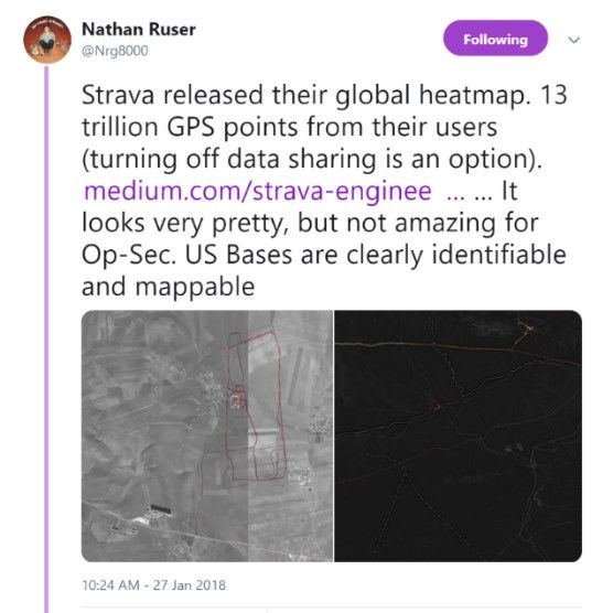
MCKENNA-FORMATTED FINAL.DOCX

592                        PENN STATE LAW REVIEW                 Vol. 123:3

satellites and smart devices, and we examine how the satellite-smart
device information nexus works. We also address how private industry’s
aggregation of data through this nexus poses a threat to individual privacy,
civil liberties, and national security.
      In so doing, we work to fill a marked gap in the privacy and cyber-
related legal literature when it comes to analyzing the technology,
surveillance capabilities, law, and regulation behind government and
commercial satellites together with private industry’s aggregation, use,
and dissemination of geolocation and other data from the satellite-smart
device information nexus. This lack of awareness about the satellite-smart
device information nexus has adverse consequences on individual privacy,
civil liberties, and the security of nation states; it impedes informed
legislation; and it leaves courts in the dark.
      A contributing factor to the lack of awareness is that commercial
remote sensing and government satellites are regulated by a byzantine
scheme of international laws, treaties, organizations, and domestic nation
states’ laws that combine to control access to satellite data, sharing of
satellite data, licensing, ownership, positioning in space, technical
requirements, technical restrictions, and liability for harm caused by
satellites. Although the satellite-smart device information nexus involves
staggering quantities of personal information, we examine how the nexus
falls outside the U.S. electronic surveillance and data legislative scheme
and why it is unimpeded by privacy decisions due to a disconnect in U.S.
Supreme Court decisions treating aerial surveillance differently than
location tracking.
      We breakdown the complex yet opaque regulatory structure
governing commercial remote sensing and government satellites. We
examine why the Strava event and others like it are—and will continue to
be—the new norm, absent significant legislative and regulatory change.
We conclude by providing a suggested roadmap for that legislative and
regulatory change.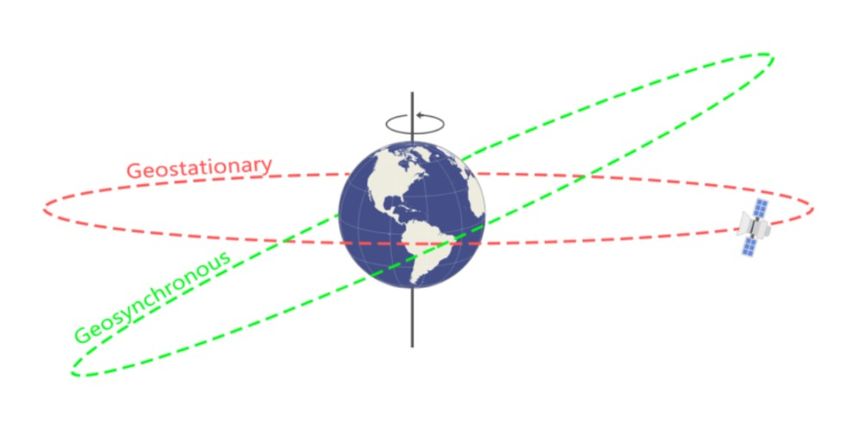
2019                THE ROLE OF SATELLITES AND SMART DEVICES                                                593

                                        Table of Contents
I.      INTRODUCTION ............................................................................... 594
II.     ARTICLE STRUCTURE AND TERMINOLOGY.............................. 596
        A. Overview of Article Structure ...................................................... 596
        B. Terminology................................................................................. 597
III.    SATELLITES: TECHNOLOGY AND INDUSTRY ........................... 603
        A. Satellites and Remote Sensing ..................................................... 604
        B. GNSS and U.S. GPS .................................................................... 606
        C. The Commercial Remote Sensing Industry and Its Use of
            Satellite Data ................................................................................ 611
IV.     SMART DEVICES .............................................................................. 615
        A. Smart Devices and GPS Receivers .............................................. 616
        B. Sensor-based Information Systems .............................................. 616
        C. Software Applications .................................................................. 621
V.      CASE STUDY: PRIVATE SECTOR AGGREGATION OF
        COMMERCIAL REMOTE SENSING, GPS, AND SENSOR
        DATA - THE STRAVA HEATMAP ................................................... 622
VI.     SATELLITES AND REMOTE SENSING: LEGAL AND
        REGULATORY FRAMEWORK ........................................................ 625
        A. International Law and Regulation ................................................ 625
        B. Regulation of U.S. GPS System ................................................... 626
        C. U.S. Regulation of Commercial Remote Sensing ........................ 627
VII.    SATELLITES AND SMART DEVICES: U.S. LAW AND
        PRIVACY CONCERNS ...................................................................... 631
        A. Constitutional Concepts of Privacy .............................................. 633
        B. The Fourth Amendment and a Disconnect in Aerial
            Surveillance/Location Tracking Jurisprudence ............................ 634
        C. The U.S. Electronic Surveillance Statutory and Data Scheme ..... 636
        D. Privacy and Civil Liberty Concerns ............................................. 639
VIII.   SATELLITE DATA AND SMART DEVICES: NATIONAL
        SECURITY CONCERNS .................................................................... 640
        A. The Strava Heatmap: Understanding the National Security
            Impacts from the Aggregation of Remote Sensing Data and
            Smart Devices .............................................................................. 642
        B. A Data Surprise: Why the U.S. Missed the Data Aggregation
            Threat ........................................................................................... 644
            1. Focusing on Other Threats to Satellites ................................. 644
            2. A Disjointed and Cumbersome Regulatory Regime .............. 646
        C. The Limits of the Current Regulations and New
            Developments .............................................................................. 651
        D. Data Aggregation Is a Persistent and Growing Concern .............. 655
IX.     RECOMMENDATIONS ..................................................................... 656
X.      CONCLUSION .................................................................................... 663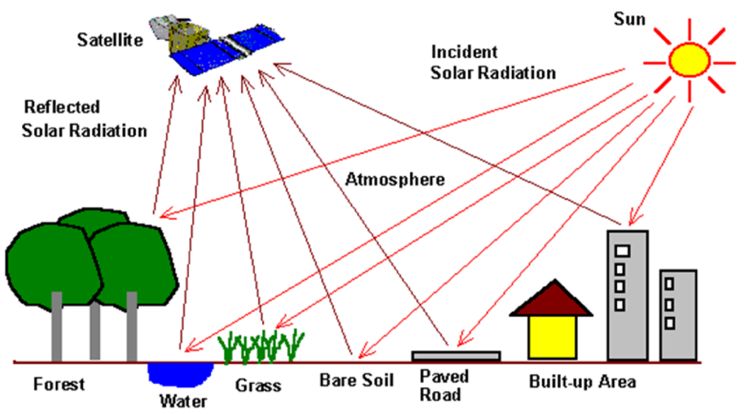
MCKENNA-FORMATTED FINAL.DOCX

594                        PENN STATE LAW REVIEW                        Vol. 123:3

      I.      INTRODUCTION

     A Fitbit did that? On January 27, 2018, 20-year old Australian
international security student Nathan Ruser tweeted: “Strava released their
global heatmap. 13 trillion GPS points from their users . . . It looks very
pretty, but not amazing for Op-Sec. US Bases are clearly identifiable and
mappable.”1
     Instantaneously, Strava, a social media platform and mobile fitness
app that works with wearable fitness devices, unintentionally
compromised numerous U.S. special ops bases around the world by
posting its “heatmap” of user activity online. Strava’s heavily-marketed
heatmap comprises aggregated data of user movement, developed by
synthesizing GPS satellite data for the movement data with satellite
imagery to give these data a geographic reference.2
     On January 30, 2018, The New York Times published a short video
about Ruser’s tweet; it showed with startling clarity how satellite images
combined with Strava’s heatmap data revealed multiple U.S. special ops
bases in remote locations in Djibouti, Afghanistan, and Niger.3 The Times
interviewed Ruser, who mused from his summer vacation in Thailand,

    1. Nathan Ruser (@Nrg8000), TWITTER (Jan. 27, 2018, 10:24 AM),
https://twitter.com/Nrg8000/ status/957318498102865920.
    2. See Drew Robb, Building the Global Heatmap, MEDIUM (Nov. 1, 2017),
https://medium.com/Strava-engineering/the-global-heatmap-now-6x-hotter-
23fc01d301de
    3. Chritiaan Tribert et al., How Strava’s Heat Map Uncovers Military Bases, N.Y.
TIMES, https://nyti.ms/2DAjwxK (last visited June 20, 2019).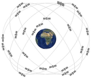
2019             THE ROLE OF SATELLITES AND SMART DEVICES                           595

“Whoever thought that operational security could be wrecked by a
Fitbit?”4 The U.S. Department of Defense (DOD) was left scrambling, and
the national security and privacy law communities were saucer-eyed with
dawning comprehension. A social media fitness app simply was not on the
Pentagon’s radar.5
      To be clear: it is not our intent to imply that Strava did anything
unlawful or violated its own terms of use and privacy policies. It did not.
Moreover, Strava provides its users clear options to turn off data sharing.
But the Strava reveal was a national security debacle and flagged
significant privacy and civil liberty concerns. How did it happen? We
explain the data aggregation behind Strava’s heatmap and explain why the
Strava event is the new norm.6 Smart devices, software applications, and
social media platforms – like Strava – routinely aggregate consumer data
from multiple data collection sources, including device-embedded
sensors, cameras, facial recognition software, and GPS, as well as from
consumer activities like social media posts, pictures, texts, email, and
contacts. These devices and apps utilize satellite data, including GPS, as a
fundamental component of their data collection arsenal. This across-
device, across-platform, and multi-sourced data aggregation is not being
done by malicious actors, but rather by private industry. Nevertheless, the
non-malicious aggregation of data poses a threat to individual privacy,
civil liberties, and national security.
      Law review articles abound that analyze the legal frameworks, ethical
complexities, and technical know-how behind smart devices, software
apps, and social media platforms and their data collection, aggregation,
use, and sale. Likewise, a multitude of articles addressing privacy concerns
and privacy-law based challenges to satellite-based mapping platforms,
like Google Earth. However, there is a marked gap in the privacy and
cyber-related legal literature when it comes to analyzing the technology,
surveillance capabilities, and law behind government and privately-owned
satellites together with the role and use of satellites and satellite data by
the private sector via smart devices and apps.
      The two groups – satellite experts/satellite law scholars on the one
hand and cyber technology experts/cyberlaw and privacy scholars on the
other – tend to stay in their own lanes when it comes to analysis of societal

     4. Isabella Kwai, What He Did on His Summer Break: Exposed a Global Security
Flaw, N.Y. TIMES (Jan. 30, 2018), https://nyti.ms/2vpTfhh.
     5. Pun intended.
     6. Cf, Ryan Pickrell, Satellite Photos Reveal A Strategic Russian Military Upgrade
on NATO’s Doorstep, TASK & PURPOSE (Oct. 18, 2018, 10:38 AM),
https://taskandpurpose.com/russian-military-buildup-kaliningrad (describing the use of
satellite imagery to detect Russian military activity); SHAPE Public Affairs Office, NATO
releases satellite imagery showing Russian combat troops inside Ukraine, NATO
NEWSROOM (Nov. 26, 2014, 6:14 PM) https://bit.ly/2L7RjVe (same).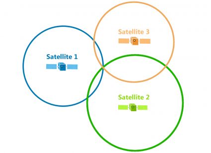
MCKENNA-FORMATTED FINAL.DOCX

596                        PENN STATE LAW REVIEW                   Vol. 123:3

and security consequences flowing from acquisition, aggregation, and use
of data from smart devices, apps, and satellites. Satellites are “up there”
and governed by space and communications law, while “down-here”
earth-based activities are governed by domestic legal authorities in the
fields of surveillance, national security and privacy.
      This gap in interdisciplinary scholarship has significant adverse
consequences on an unaware public and the security of nation states. The
Strava debacle made that abundantly clear. Privacy law scholarship has
not comprehensively addressed questions like: How is government-owned
satellite data made available to private entities? Who can own satellites?
Who can access satellite data? How is it that a start-up using aggregated
data from commercial, publicly available sources, such as satellite data,
users’ smart devices, and software apps, can create a national security
crisis overnight? To complicate matters, commercial and government
satellites are regulated by a byzantine scheme of international laws,
treaties, organizations, and domestic nation states’ laws that combine to
control access to satellite data, sharing of satellite data, licensing,
ownership, positioning in space, technical requirements, technical
restrictions, and liability for harm caused by satellites. With few
exceptions, scholarship addressing the law’s regulation of satellites and
satellite data tends to fall squarely in either the traditional communications
and space law camp or within technical and privacy scholarship regarding
satellite technology, capabilities, and advances in these areas.

      II.     ARTICLE STRUCTURE AND TERMINOLOGY

      A.      Overview of Article Structure

      This interdisciplinary paper begins to fill this void in the scholarship
and is structured as follows.
      In Section II(B), we address confusion caused by terminology and
provide a list of defined terms as used in this article.
      In Section III, we provide an overview of the technical capabilities of
satellites, explain the basics of global position systems (GPS) satellite
technology, and examine how the private sector uses data derived from
and generated by commercial remote sensing satellite systems.
      In Section IV, we analyze how smart devices, wearables, apps, social
media platforms (like Strava), and wireless communications operate off
the backbone of GPS receivers, microelectromechanical sensors, and
satellite data. We explore how the private sector harnesses this satellite-
device-software information nexus in ways not fully appreciated by the
public or policymakers.
2019 THE ROLE OF SATELLITES AND SMART DEVICES 597
In Section V, we provide a case study, using the Strava heatmap, to
demonstrate private sector use of commercial remote sensing and GPS and
sensor data.
In Section VI, we provide an overview of the legal and regulatory
frameworks, at the international and domestic levels, that govern space
law, satellites, GPS, and the commercial remote sensing industry.
In Section VII, we provide a summary of the U.S. legal landscape
governing electronic surveillance technologies, and we consider smart
devices and satellite-generated and satellite-derived data in the context of
privacy law, including constitutional concepts and Supreme Court
jurisprudence. Finally, we assess the significant privacy and civil liberty
challenges posed by the proliferation of smart devices, apps, and online
communication platforms when combined with satellite data.
In Section VIII, we describe and analyze the specific threats to U.S.
national security posed by the aggregation of satellite-generated data by
private sector companies. We explore how and why the U.S. national
security establishment failed to anticipate these threats, despite a slew of
regulations that permit the U.S. government to restrict the collection, use,
and dissemination of satellite data. We examine the shortcomings in the
current regulatory regime, and we preview pending developments in the
law. Finally, we explain that the Strava event was only a harbinger of a
persistent and growing threat.
In Section IX, we propose a set of recommendations in broad
brushstrokes to bridge the legal and regulatory chasms in this area while
grappling with the powerful and transformative role that data from remote
sensing satellites plays in our daily endeavors.
B. Terminology7
In an article tackling technical subjects like satellites, smart devices,
embedded sensors, and data aggregation from a legal standpoint, our
research spanned a wide array of research sources and revealed a
confusing hodge-podge of terminology. The varying terms used by
engineers, legislators, reporters, legal scholars, technical experts, and
attorneys – in many cases to describe or refer to the exact same thing –
leads to continued confusion, lack of understanding, and separation of
knowledge and disciplines. The term “GPS satellite data,” for example, is
alternatively referred to as geospatial data, digital geolocation data,
geodata, GPS, satellite location data, and remote sensing data.
7. The authors gratefully wish to acknowledge the research and citation assistance
with this terminology section provided by Benjamin L. Cohen, J.D., Penn State Dickinson
Law, and Wyatt C. Weisenberg, J.D. Candidate, Penn State Dickinson Law, J.D.
anticipated May 2020.MCKENNA-FORMATTED FINAL.DOCX
598 PENN STATE LAW REVIEW Vol. 123:3
To alleviate this confusion, the following terms are defined as
follows:
5th Generation Wireless (5G) is a new form of wireless networking
technology which promises download speeds approximately 20 times
faster than the current 4th Generation (4G) technology. Previously,
wireless networking operated using the radio-frequency spectrum. 5G
marks a shift away from the radio-frequency spectrum to the millimeter
wave spectrum. Unlike the radio waves of prior generations, millimeter
waves cannot easily transmit through obstacles. 5G wireless thus requires
a denser number of cell sites. 5G’s denser network of cell sites allows
increased transmission speeds. 5G simultaneously relies on a traffic-
signaling system to identify the most efficient delivery route. The new cell
sites transmit information simultaneously across the same frequency. This
transmission principle can potentially double the capacity of wireless
networks at their most fundamental physical layer.8
Cellular phones are two-way telecommunication devices that are
perhaps best understood as sophisticated radios.9 The root “cell” in cellular
refers to geographic regions often illustrated as hexagons, like that of a
bee’s honeycomb.10 Cellular phones contain a low-power transmitter that
transmits and receives information through a network of cell sites. 11 Cell
phones scan for the cell site that offers the strongest signal in its
geographic area.12 The cell phone performs these scans every seven
seconds or when the signal strength from one cell site or tower weakens,
regardless of whether a call is placed.13
Cell sites, also referred to as cell towers, sit along areas where three
hexagonal cells connect.14 Each cell site or cell tower contains a radio
transceiver and base station controller that receives and transmit verbal
8. See Charlotte Lee, The 5G Economy: How 5G will Impact Global Industries, The
Economy, and You, MIT TECHNOLOGY REVIEW (Mar. 1, 2017), https://bit.ly/2o9T9V1; see
also Amy Nordrum et al., Everything You Need to Know About 5G, IEEE SPECTRUM BLOG
(Jan. 27, 2017, 7:00 PM), https://bit.ly/2OV1Dhh.
9. CLIFFORD S. FISHMAN & ANNE T. MCKENNA, WIRETAPPING & EAVESDROPPING:
SURVEILLANCE IN THE INTERNET AGE § 28:2 (3d ed. Supp. 2018), Westlaw WIRETAP; see
also In re Application for Pen Register and Trap/Trace Device with Cell Site Location
Authority, 396 F. Supp. 2d 747, 750–751 (S.D. Tex. 2005). For a general background on
cellular telephones, see S. REP. NO. 99-541 (1986), as reprinted in 1986 U.S.C.C.A.N.
3555, 3563.
10. See In re Application for Pen Register and Trap/Trace Device with Cell Site
Location Authority, 396 F. Supp. 2d at 750 (describing cellular phone technology).
11. See id.
12. Id.
13. Id.
14. Id.2019 THE ROLE OF SATELLITES AND SMART DEVICES 599
communications from one cellular phone to another.15 Cell sites do not
only process voice data; cell sites also receive location data.
Cell Site Location Information (CSLI) is a time-stamped record of
cell phone’s location that is generated each time a cellular phone scans or
connects to a cell site.16 As noted, cell phones continuously scan for nearby
cell sites. Cell phones connect to the cell site when placing a phone call,
sending text messages, and when using a cellular phone application.17
While the accuracy of the CSLI varies dependent upon the concentration
of cell sites within a given area, the ubiquity of cellular phones results in
an increasingly compact coverage areas, and thereby an increasingly
accurate CSLI.18 With the proliferation of smart phones, mobile apps and
texting communication platforms, “modern cell phones generate
increasingly vast amounts of increasingly precise CSLI.”19 The accuracy
of CSLI is further compounded by the commercialization of location data
CSLI, incentivizing the cellular providers to store CSLI beyond that
required by law.20
Cellular tracking is a surveillance method that uses CSLI to
determine real-time movement and historical movement (over time) by
comparing the difference in signal strength from multiple different cell
sites.21 This process is also known as cellular triangulation and is distinct
from geolocation tracking, which is defined below.
Geolocation data refers to digital geographic data and information
concerning objects or phenomena that are directly or indirectly associated
with a location relative to the Earth.22 Geolocation data reflects the
geographical (latitudinal and longitudinal) location of an Internet-
connected device or GPS receiver enabled device.23 Geolocation data
collected from such devices is used, accessed, and disseminated by a
variety of apps, and even other smart devices.24 The geolocation data
15. Id.
16. See Carpenter v. United States, 138 S. Ct. 2206, 2211–12 (2018).
17. See id. at 2212.
18. Id.
19. Id. at 2212.
20. See generally id. (noting that wireless carriers often sell aggregated location
records); Enhanced 911 – Wireless Services, FED. COMMC’NS COMM’N,
https://www.fcc.gov/general/enhanced-9-1-1-wireless-services (last visited June 20, 2019)
(requiring cell network providers be able to provide relatively precise locations of persons
placing 911 calls from mobile devices)
21. See Aaron Blank, The Limitations and Admissibility of Using Historical Cellular
Site Data to Track the Location of a Cellular Phone, 18 RICH. J.L. & TECH. 3, 7–10; see
also FISHMAN & MCKENNA, supra note 9, § 28:4.
22. Geolocating Carmen Sandiego, GRAVITATE (Dec. 14, 2018),
https://www.gravitatedesign.com/blog/what-is-geolocation/.
23. Id.
24. Id.MCKENNA-FORMATTED FINAL.DOCX
600 PENN STATE LAW REVIEW Vol. 123:3
collected reflects the geolocation of the device or server, in other words,
“if you leave your phone in your car and go for an hour-long run in
silence . . ., your geolocation history for that hour is the physical location
of your car (according to your phone).”25 In contrast, if “your fitness
tracker traveled with you the whole time on your wrist, its geolocation
history for that hour is wherever you ran.”26 Of course, if your phone is
synced with your fitness tracker or other wearable device, your phone will
collect the geolocation data from the fitness tracker when the two devices
next connect.
Geolocation tracking is a surveillance method similar to cellular
tracking but relies on GPS satellite data captured and stored by GPS
receivers, rather than cell-site location data. Geolocation tracking relies on
a trilateration process, as opposed to triangulation.27
Geospatial data is data that has a geographic component or includes
locational information, such as geographic data in the form of coordinates,
address, city, or ZIP code. Geospatial data can originate from GPS data,
satellite imagery, and geotagging.28 Geospatial data may also be referred
to as location data or spatial data and is emerging as an important source of
information both in traditional and in big data analytics.29
Geospatial technology refers to the technology used to “acquire,
manipulate, and store geographic information.”30 Examples of geospatial
technologies include GPS and remote sensing, among others.31
GPS satellite data means electronic information about the time and
position of a GPS satellite.32
GPS chips or GPS receivers are computer processors that receive
GPS signals from satellites to determine the device’s geolocation. Devices
with a GPS chip typically have wireless connectivity which enables the
device to transmit data to a secondary device, such as a personal computer
or mobile phone.33
25. Id.
26. Id.
27. Daniel Ionescu, Geolocation 101: How It Works, the Apps, and Your Privacy,
PCWORLD (Mar. 29, 2010), https://www.pcworld.com/article/192803/geolo.html.
28. Caitlin Dempsey, What is the Difference Between GIS and Geospatial?, GIS
LOUNGE (Jan. 14, 2014), https://www.gislounge.com/difference-gis-geospatial/.
29. Id.
30. Id.
31. Id.
32. See What is WAAS?, GARMIN, https://www8.garmin.com/aboutGPS/waas.html
(last visited June 20, 2019).
33. See Amanda Thomas, How Micro GPS Tracking Chips Work, TRACKIMO (Jul. 26,
2016), https://trackimo.com/micro-gps-tracking-chips/; see also Daniel Rubino, GPS vs.2019 THE ROLE OF SATELLITES AND SMART DEVICES 601
Assisted-GPS or aGPS is the combined use of GPS along with Wi-Fi
and cell-tower triangulation (see definition below) to pinpoint the location
of a device.34 Assisted-GPS pinpoints location very accurately, especially
indoors where GPS signals might not be strong.35
Internet of Things (IoT) refers to a decentralized network of
embedded sensors and processors, enabling a range of possible
communications: person-to-device, device-to-device, or device-to-grid.
These systems monitor and manage IoT devices.36
IoT devices are physical objects capable of connecting to the internet,
similar to other smart devices, with a stronger emphasis on device-to-grid
communications to enable data analytics.37
Remote sensing is a method of data collection through instruments or
sensors that act as a proxy to direct forms of information that rely on
physical contact.38
Commercial remote sensing space capabilities as defined in the U.S.
Commercial Remote Sensing Policy “refers to privately owned and
operated space systems licensed under the Land Remote Sensing Policy
Act of 1992, their technology, components, products, data, services, and
related information, as well as foreign systems whose products and
services are sold commercially.” 39
Remote sensing space capabilities are similarly defined in the Policy
as “all remote sensing space systems, technology, components, products,
data, services, and related information.”40 Space systems include the
spacecraft’s remote sensing hardware, software, and cargo as well as the
spacecraft’s ground stations, command facilities, and the connecting
networks. Data processing components and exploitation hardware and
aGPS: A Quick Tutorial, WINDOWS CENTRAL (Jan. 3, 2009),
https://www.windowscentral.com/gps-vs-agps-quick-tutorial.
34. See Tracy V. Wilson, How GPS Phones Work, HOWSTUFFWORKS,
https://bit.ly/2HdZvze (last visited on June 20, 2019).
35. See Jules G. McNeff, The Global Positioning System, 50 IEEE TRANSACTIONS ON
MICROWAVE THEORY AND TECH. 645, 646–647 (2003), https://bit.ly/2VpS5Rq.
36. See MCKINSEY GLOBAL INSTITUTE, THE INTERNET OF THINGS: MAPPING THE
VALUE BEYOND THE HYPE 17 (2015), https://mck.co/2gyPezB; see also THE
HAMMERSMITH GROUP, INTERNET OF THINGS: NETWORKED OBJECTS AND SMART DEVICES,
(2010), https://bit.ly/2UXcA8u.
37. See Mayank Singh, Smart, Connected and IoT Device, ENGINEERING ECKOVATION
(Jun. 6, 2018), https://engineering.eckovation.com/smart-connected-iot-devices/.
38. See 15 C.F.R. § 966.3 (2018) (defining remoting sensing system as applied to
satellites); 51 U.S.C. § 60101(4) (defining land remote sensing).
39. NAT’L OCEANIC & ATMOSPHERIC ADMIN., U.S. COMMERCIAL REMOTE SENSING
POLICY FACT SHEET 1 (April 25, 2003), https://bit.ly/2VzywpC [hereinafter REMOTE
SENSING POLICY].
40. Id.MCKENNA-FORMATTED FINAL.DOCX
602 PENN STATE LAW REVIEW Vol. 123:3
software with remote sensing characteristics may also be included in the
definition.41
Smart or smart devices are physical objects capable of connecting to
the internet, either directly or indirectly through a network, to
communicate information with other networked devices; and have
computer processing capabilities for collecting, sending, receiving, or
analyzing data.42 Smart has now colloquially become a prefix used to
modify a word, signaling that the modified word has some form of
networking and processing capabilities. Put differently, smart + X refers
to X with the ability of networking and computer processing. For example,
smartcity refers to a city that has incorporated networking and computer
processing technology into its urban environment.
Smartphones refer to mobile or cellular phones embedded with high-
performance microprocessors and other sensors powered by a mobile
operating system featuring capabilities like a traditional computer.43
Software applications, or apps, are software programs that function
on top of a device’s operating system, allowing the user to perform all
sorts of tasks from editing documents to playing games. Applications have
been around for as long as computers, but the term ‘app’ is associated with
the software that runs on a smartphone or tablet device.44
Triangulation is the process of determining the coordinates of a point
based on the known location of two other points. If the direction (but not
distance) from each known point to the unknown point can be determined,
then a triangle can be drawn connecting all three points. While only the
length of one side of the triangle is known at first (the side connecting the
two known points), simple trigonometry reveals the lengths of the other
sides and so the position of the third point. In the context of cell site
information, the two known points are the antenna towers, the third point
is the cellular telephone, and the direction from each tower to the phone is
41. Id.
42. See Internet of Things (IoT) Cybersecurity Improvement Act of 2017, S. 1691,
115th Cong. § 2 (2017); SMART IoT Act, H.R. 6032, 115th Cong. § 2 (2017); S.B. 327,
2017 Leg. (Cal. 2018).
43. See What is a smartphone?, LENOVO, https://lnv.gy/2WAIPar (last visited June
20, 2019).
44. See Marziah Karch, A Beginner’s Guide to Apps, LIFEWIRE, (last updated Jan. 04,
2019), https://bit.ly/2HbzNeK; What is an app?, BBC WEBWISE BLOG,
http://www.bbc.co.uk/webwise/0/27488178 (last updated Jun. 2, 2014, 2:26 PM);
Understanding Mobile Apps, FED. TRADE COMM’N, https://bit.ly/28KjSlG (last visited June
20, 2019).2019 THE ROLE OF SATELLITES AND SMART DEVICES 603
discerned from the information about which face of each tower is facing
the phone.45
Trilateration is the process of determining the position of a point
based on the known location and known distance to three other points.
When a GPS device receives a signal from a satellite, the system calculates
the distance between the receiver and the satellite, identifying the possible
position of the device as
anywhere within the satellite’s
signal radius. This process
repeats with another satellite.
With two signals, the precise
position could be any of the two
points where the two circles of
signal coverage intersect. This
is still not precise enough,
leading to a third satellite
joining the process, revealing
the device’s precise location
where all three circles intersect. Each satellite is at the center of a sphere
with the GPS receiver found in the location where the satellites intersect.46
Wearable devices describe physical objects such as fitness trackers,
smartwatches, or smart glasses worn by the user with embedded or
integrated processors and sensors that are typically networked to a mobile
device, offering consumers and businesses access to real-time, highly
personalized information.47
III. SATELLITES: TECHNOLOGY AND INDUSTRY
The possibility of integrating remote sensing data into
local. . .databases and using the databases in conjunction with
locational GPS data has created opportunities for new types of
information applications that were not possible using photographic
remote sensing data alone.48
45. See FISHMAN & MCKENNA, supra note 9, at § 28:4; see also Trilateration vs
Triangulation – How GPS Receivers Work, GIS GEOGRAPHY, https://bit.ly/2Q0kfgz (last
updated Mar. 4, 2019).
46. Trilateration vs Triangulation – How GPS Receivers Work, GIS GEOGRAPHY,
https://bit.ly/2Q0kfgz (last updated Mar. 4, 2019).
47. Disrupter Series: Wearable Devices: Hearing Before the Subcomm. on
Commerce, Mfg., and Trade, Comm. on Energy and Commerce, 114th Cong. 2–3 (2016)
(statement of Hon. Michael C. Burgess, Rep. from Tex.), https://bit.ly/2WwbhtY.
48. NAT’L RESEARCH COUNCIL, USING REMOTE SENSING IN STATE AND LOCAL
GOVERNMENT: INFORMATION FOR MANAGEMENT AND DECISION MAKING 17 (Nat’l
Academies Press 2003).MCKENNA-FORMATTED FINAL.DOCX
604 PENN STATE LAW REVIEW Vol. 123:3
After the January 2018 Strava reveal, this 2003 statement from a
National Research Council report proves prescient. The posting of the
Strava heatmap, with its immediate national security impact, demonstrates
this application of locational GPS data from the smart devices onto
satellite-derived topography and land use backgrounds. This section
provides a basic overview of the technical capabilities of satellites,
examines how the private sector uses data generated from commercial
remote sensing satellite systems, and overviews global positioning system
(GPS) capabilities.
A. Satellites and Remote Sensing
Satellites work in a similar
way to the human eye. Neither
receives information about an
entire object; they sense the
presence (or absence) of a feature
remotely. Touch is direct sensing
– you are in physical contact with
the object. Remote sensing is the
process of acquiring information
about your surroundings without
being in contact with it. Both the
eye and the Earth-orbiting
satellite sense reflected or
emitted energy, then process and
interpret that data into usable information about the world around us.
Satellites carry a variety of instruments to capture different parts of
the energy spectrum, including visible (what you see is what you get),2019 THE ROLE OF SATELLITES AND SMART DEVICES 605
infrared (temperature), and microwave (clouds, rain, ice, snow) parts of
the spectrum. Using data from more than one of these sensors in
combination empowers us to distinguish between various types of clouds
and weather systems, different types of land cover (ploughed fields,
grasslands, cities, forests, lakes, ocean), and topography. The end result of
this process is given in
the Landsat example to
the right.49 These four
merged images are
developed by combining
information from many
satellite retrievals of the
Smoky Mountains in
each season over 2012
and 2013 and capture
seasonal differences in
vegetation and other
features. In broad terms,
this is the process for
visualizing land surface
information, such as that
in the Strava images.
Aggregation of satellite data by commercial entities includes data
from satellites in orbits categorized as geostationary, geosynchronous, and
semi-synchronous. Geostationary satellites orbit above the equator in high
Earth orbit at an altitude of roughly 36,000 kilometers. This high altitude
is necessary for the satellite to “sit” in a constant relative location above
the Earth’s surface and allows the satellite to lie on the same plane as the
equator. The advantages of geostationary satellites are constant and
consistent views of the same areas. The disadvantage is that the resolution
of the satellite is diminished by distance. Geostationary satellites are
generally used for weather monitoring, and search and rescue beacons.50
49. Holli Riebeek, How to Interpret a Satellite Image: Five Tips and Strategies,
NASA EARTH OBSERVATORY (2013), https://earthobservatory.nasa.gov/
features/ColorImage.
50. Geosynchronous vs Geostationary Orbits, GIS GEOGRAPHY (Feb. 23, 2018),
https://gisgeography.com/geosynchronous-geostationary-orbits/.MCKENNA-FORMATTED FINAL.DOCX
606 PENN STATE LAW REVIEW Vol. 123:3
51
Geosynchronous satellites are located in “a sweet spot above the
Earth” where the satellite is able to match the Earth’s rotation.52 Thus, a
geosynchronous satellite’s orbit synchronizes with the rotation of the
Earth, and it matches the time it takes for the Earth to rotate on its axis -
23 hours, 56 minutes and 4.09 seconds.53 Geosynchronous satellites move
in a constant low-Earth orbit, with an altitude of roughly 350 kilometers.54
The low orbit and proximity to the Earth’s surface allows for higher
resolution images, and makes geosynchronous satellites particularly useful
for telecommunications and other remote sensing applications. 55
Semi-synchronous satellites orbit in a medium Earth orbit located
approximately 20,200 kilometers above the surface of the planet. Satellites
in semi-synchronous orbit take approximately 12 hours to complete an
orbit, twice as fast as the 24-hour cycle for geosynchronous satellites.
These semi-synchronous satellites make up the global position systems
(GPS) satellites systems that are critical to the aggregation of locational
data.
B. GNSS and U.S. GPS
To understand how private industries typically interact with satellites
and satellite data, it is helpful to understand the basics of GPS satellite
51. Id.
52. Id.
53. Id.
54. Id.
55. Id.2019 THE ROLE OF SATELLITES AND SMART DEVICES 607
technology as GPS is one of the most commercially common uses of
satellites. Before we further describe GPS satellite technology, it is
important to remember that the Strava debacle was not caused only by
Strava’s interaction with satellites, but also by Strava’s users’ interaction
with satellites. This begs the question: how do individuals interact with
satellites and satellite data? To help answer this question, meet Corey, a
U.S. citizen residing in the U.S. Like many Americans, Corey uses a
smartphone and a wearable fitness device. Corey does not exist, but Corey
does represent the average person. Corey could be you; Corey could be
me. For illustrative purposes, imagine Corey just purchased the newest
iPhone. Corey inputs Corey’s home address into the phone’s navigation
application and begins the journey home. The U.S. GPS system and
Corey’s smart devices go to work to get Corey home. To understand how
this happens, we turn back to the satellite systems at play here. What is
GPS and how does work?
The Global Navigation Satellite System (GNSS) is the standard
generic term for satellite navigation systems that provide autonomous geo-
spatial positioning with global coverage.56 GNSS is a term used
worldwide, and sometimes used interchangeably with the term GPS
(Global Positioning System). As discussed more fully below, the major
GNSS Systems are GPS (U.S.), GLONASS (Russia), Galileo (European
Union), BeiDou (China), and other regional systems.57
The U.S. GPS is a satellite-
based navigation system owned
and developed by the U.S.
Government. The U.S. GPS
constellation consists of 31
operational satellites out of
which 24 are active at any given
time to cover at least 95% of the
earth.58 The satellites fly in
medium Earth orbit at an
altitude of approximately
20,200 kilometers,59 as
56. Michael Venezia, What is the Difference Between GNSS and GPS?, SYMMETRY
ELECTRONICS (Dec. 16, 2015), https://www.semiconductorstore.com/blog/2015/What-is-
the-Difference-Between-GNSS-and-GPS/1550/.
57. Id. Access to multiple satellites increases accuracy, redundancy and availability at
all times; and if one GNSS system fails, GNSS receivers can pick up signals from other
systems.
58. Space Segment, GPS.GOV, https://www.gps.gov/systems/gps/space/ (last updated
Mar. 21, 2019). For more info on technical aspects of the GNSS, see Technical
Documentation, GPS.GOV, https://www.gps.gov/technical/ (last updated Sept. 5, 2018).
59. Id.MCKENNA-FORMATTED FINAL.DOCX
608 PENN STATE LAW REVIEW Vol. 123:3
depicted in the diagram of the U.S. GPS constellation.60 The U.S. Air
Force is responsible for the GPS satellites, and expects to launch its next
GPS satellite in July 2019.
GPS satellites are placed into orbits in such a way that any point on
earth is in the direct line of sight of at least four satellites. GPS satellites
broadcast radio signals that contain the time and then location of the GPS
satellites.61 GPS receivers are “chips” that can read the signals that GPS
satellites broadcast.62 These receiver chips essentially read the digital radio
signals at the frequency in which the satellites broadcast the digital
signals.63 GPS receivers read the radio signals from any four satellites from
which the GPS receiver gets a signal, and then doing some computations,
the GPS receiver infers its own or its device’s position using trilateration.64
Thus, the GPS satellites, apart from broadcasting their own location, do
not take part in the process of gathering geolocation data or geolocation
tracking.65
Fortunately for Corey (or for Apple, the manufacturer of Corey’s
iPhone), civilian use of the U.S. GPS satellite system is free. Because use
of U.S. GPS is free, numerous private companies develop chips
compatible with U.S. GPS.66
How does a smart device use GPS? Recall that Corey is using a
smartphone to determine directions home. Corey inputs the address into a
navigation application used by the smart phone. The navigation app uses
information collected from the GPS chip in the phone to provide Corey
with the fastest route home.67 The phone’s GPS chip receives digital radio
signals at the frequency in which the satellites broadcast the digital signals,
60. Id.
61. GPS satellites have atomic clock in them that allow the satellites to keep very
accurate time and these clocks are adjusted daily to maintain unanimity with time on earth.
GPS satellites have a decided orbit and it is easy to know their location at any given time.
Id.
62. Patrick Bertagna, How Does a GPS Tracking System Work?, EE TIMES (Oct. 26,
2010), https://www.eetimes.com/document.asp?doc_id=1278363.
63. Id.
64. Marshall Brain & Tom Harris, How GPS Receivers Work, HOWSTUFFWORKS 1,
https://electronics.howstuffworks.com/gadgets/travel/gps.htm (last visited June 20, 2019).
Specifically, for a discussion of trilateration, see id. at 3,
https://electronics.howstuffworks.com/gadgets/travel/gps2.htm.
65. Wilson, supra note 34.
66. Sarah Laskov, The Plane Crash That Gave Americans GPS, THE ATLANTIC (Nov.
3, 2014), https://www.theatlantic.com/technology/archive/2014/11/the-plane-crash-that-
gave-americans-gps/382204/.
67. See Manisha Priyadarshini, Which Sensors Do I Have In My Smartphone? How
Do They Work?, FOSSBYTES (Sept. 25, 2018), https://fossbytes.com/which-smartphone-
sensors-how-work/.2019 THE ROLE OF SATELLITES AND SMART DEVICES 609
allowing the application to gather relevant time and location data from the
digital signals.68
As GPS satellites do not actively participate in location gathering but
passively broadcast signals for everyone and anyone to read, billions of
mobile devices and other GPS-chip embedded devices are able to use GPS
simultaneously.69 Recall the assisted-GPS discussion above. When a
mobile app is in use, the app is able to utilize assisted-GPS, which is GPS
receiver chip data in conjunction with Wi-Fi and cell-tower triangulation,
to precisely pinpoint the location of the device.70 Assisted-GPS pinpoints
location with precise physical accuracy, especially indoors where GPS
signals might not be strong.
As noted, GPS is a system owned and operated by the U.S.
Government, and the U.S. can selectively decide to deny any nation access
to GPS data.71 While GPS was initially developed by and for the U.S.
military, free, worldwide use for civilians was enabled in 1983.72 Initially,
the U.S. scrambled the signal to limit GPS accuracy for national security
purposes, but the result was that the U.S. GPS satellites were too
inaccurate for viable use in everyday commercial activities. In 2000,
President Clinton made the unscrambled signal available to the public.73
The U.S. GPS broadcasts in L1 through L5 frequencies.74 Of these,
the L1 and L5 can be used for civilian purposes whereas the L2 has some
frequencies dedicated to military use.75 L2 is encrypted and only a device
with the correct decryption key can access that code.76 The L5 band is a
newly added band that provides an internationally-protected range for
68. See id.
69. McNeff, supra note 33, at 646–47.
70. Wilson, supra note 34.
71. Ishan Srivastava, How Kargil spurred India to design own GPS, THE TIMES OF
INDIA (Apr. 5, 2014), https://timesofindia.indiatimes.com/home/science/How-Kargil-
spurred-India-to-design-own-GPS/articleshow/33254691.cms. The United States denied
India access to the GPS satellites during the Kargil War in 1999 which led to India
developing its own satellite system consisting of seven satellites that cover the entire
landmass of India. Id.
72. Allegedly, the U.S. made its GPS satellites free and open to civilian use after
Russia shot down a Korean civilian airliner that strayed from its flight path and entered
Russian territory. See Mark Sullivan, A Brief History of GPS, PCWORLD (Aug. 9, 2012,
7:00 AM), https://www.pcworld.com/article/2000276/a-brief-history-of-gps.html.
73. Juquai McDuffie, Why the Military Released GPS to the Public, POPULAR
MECHANICS (June 19, 2017),
https://www.popularmechanics.com/technology/gadgets/a26980/why-the-military-
released-gps-to-the-public/; Clinton Acts to Make GPS More Accurate, N.Y. TIMES (May
2, 2000), https://www.nytimes.com/2000/05/02/technology/clinton-acts-to-make-gps-
more-accurate.html.
74. New Civil Signals, GPS.GOV, https://www.gps.gov/systems/gps/modernization/
civilsignals/ (last visited June 20, 2019).
75. Id.
76. Id.MCKENNA-FORMATTED FINAL.DOCX
610 PENN STATE LAW REVIEW Vol. 123:3
aeronautical navigation, promising little or no interference under all
circumstances.77 In the early 2000s, GPS accuracy was about 20 feet;
however, since the deployment of satellites using the L5 band, the
accuracy is up to 12 inches.78 New GPS receivers using this band can pin-
point location to within a foot, anywhere on earth.79
Other countries also have GNSS systems or are rapidly developing
and deploying their own GNSS GPS-like systems. Russia has GLONASS,
a GNSS system with global coverage,80 and the EU has Galileo. China has
engaged in rapid development and deployment, launching 18 GPS
satellites in 2018
alone, and France is
also developing its
own GNSS systems
for worldwide
coverage.81 The goal
– independence from
the U.S. monopoly on
GPS. This December
2018 techcrunch.com
research graph by
Arman Tabatabi
summarizes 2018
GPS satellite development and launch activity by major nation states.82
Because the U.S. GPS was the first GNSS satellite system to be made
available for free use by civilians worldwide, device-manufacturers in the
U.S and elsewhere, including cellular and smart device manufacturers,
developed GPS receiver chips that were compatible with the U.S. GPS
satellites.
77. Id.
78. Samuel K. Moore, Superaccurate GPS Chips Coming to Smartphones in 2018,
IEEE SPECTRUM (Sept. 21, 2017, 1:00 PM), https://spectrum.ieee.org/tech-
talk/semiconductors/design/superaccurate-gps-chips-coming-to-smartphones-in-2018;
Jacob Kastrenakes, GPS will be Accurate within One Foot in some Phones Next Year, THE
VERGE (Sept. 25, 2017, 2:32 PM), https://www.theverge.com/circuitbreaker/
2017/9/25/16362296/gps-accuracy-improving-one-foot-broadcom.
79. Moore, supra note 78.
80. Danny Crichton & Arman Tabatabai, The GPS Wars have Begun, TECHCRUNCH
(Dec. 21, 2018), https://techcrunch.com/2018/12/21/the-gps-wars-have-begun/.
81. Id.
82. Id.2019 THE ROLE OF SATELLITES AND SMART DEVICES 611
C. The Commercial Remote Sensing Industry and Its Use of
Satellite Data
Elevate your perspective. Don’t speculate; quantify. Tap into the
DigitalGlobe to extract insights and validate critical decisions.
DigitalGlobe makes valuable location-based information accessible to
those who need it—anywhere, anytime.83
That’s one marketing tagline by DigitalGlobe, one of largest
commercial remote sensing satellite owners and operators. Now that we
understand how satellites work, this section summarizes the commercial
remote sensing industry and describes how private companies collect and
use satellite generated data. In the last few years, significant media and
scholarly attention has focused on the use of unmanned aerial vehicles
(UAVs), or drones by the both private sector and government. While
UAVs provide a cheap and readily accessible means of aerial surveillance
and data collection,84 commercial entities have engaged in aerial data
collection long before drones became part of our lexicon. Private
companies have been capturing and commercializing satellite data and
satellite images of our planet for decades.85
In 1994, the U.S. government granted Lockheed Martin one of the
first licenses for commercial satellite high-resolution imagery. With that
license, the company developed IKONOS, the first commercial remote
sensing system satellite.86 Launched in 1999, it was the first commercial
satellite to collect high-resolution imagery of the Earth, and to make it
publicly available.87 Since the 1999 launch of IKONOS, the number of
commercial actors engaged in the remote sensing industry has expanded
significantly. The commercial remote sensing services market is estimated
to reach $21.62 billion by 2022; that growth is being fueled by defense and
83. Home, DIGITALGLOBE, https://www.digitalglobe.com/ (last visited June 20, 2019)
(italics added for emphasis). (Taglines on DigitalGlobe’s website change frequently. The
above tagline appeared in April of 2019.)
84. See, e.g., Stephen Rice, Eyes In the Sky: The Public Has Privacy Concerns About
Drones, FORBES (Feb. 4, 2019, 10:00 AM), https://bit.ly/2Hes5iU; Domestic Unmanned
Aerial Vehicles (UAVs) and Drones, ELEC. PRIVACY INFO. CTR.,
https://epic.org/privacy/drones/ (last visited June 20, 2019); ANN CAVOUKIAN, INFO. &
PRIVACY COMM’R OF ONT., PRIVACY AND DRONES: UNMANNED AERIAL VEHICLES (2012),
https://bit.ly/30cngz2.
85. See Janna J. Lewis & Lauren R. Caplan, Drones to Satellites, Should Commercial
Aerial Data Collection Regulations Differ by Altitude?, SCITECH LAWYER, Summer 2015,
at 10, 10.
86. Christopher Lavers, The Origins of High Resolution Civilian Satellite Imaging -
Part 2: Civilian Imagery Programs and Providers, DIRECTIONS MAGAZINE (Feb. 4, 2013),
https://www.directionsmag.com/article/1646.
87. Id.MCKENNA-FORMATTED FINAL.DOCX
612 PENN STATE LAW REVIEW Vol. 123:3
private sector use of remote sensing services, supported by satellites, as
well as Big Data applications.88
Two of the most significant commercial satellite players are
DigitalGlobe and SPOT Image.89 GeoEye was a third large player, but
DigitalGlobe purchased GeoEye and all of its subsidiaries and satellites in
2013.90 These commercial entities use their remote sensing satellites to
collect various sorts of data, including images, location data, and real-time
surveillance, and then sell that satellite data to both private sector and
governments. But the raw satellite data is not the only commodity being
sold. These companies also aggregate data and provide geospatial analysis
of the satellite-generated data, and then sell that analysis to app developers,
social media platforms and government entities. Several examples from
the commercial remote sensing industry may prove helpful in appreciating
the scale and scope of the data collection and use.
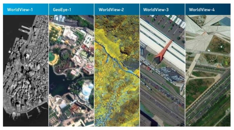
91
Let’s start with DigitalGlobe. The montage above shows differing
types of images and data captured by DigitalGlobe’s various satellites.
According to DigitalGlobe’s 2018 brochure, its constellation of satellites
88. Remote Sensing Services Market Will Worth $21.62 Billion by 2022: Report,
GEOSPATIAL WORLD (Oct. 31, 2017), https://www.geospatialworld.net/news/remote-
sensing-services-market-will-worth-21-62-billion-2022-report/.
89. Id.
90. Private Remote Sensing System License Summary of GeoEye-1, NAT’L OCEANIC
& ATMOSPHERIC ADMIN. (Feb. 28, 2013), https://www.nesdis.noaa.gov/CRSRA/files/
GeoEye1.pdf. [hereinafter GeoEye-1 License].
91. DIGITALGLOBE, THE DIGITALGLOBE CONSTELLATION (2018), https://dgv4-cms-
production.s3.amazonaws.com/uploads/document/file/126/Constellation_Brochure_2018.
pdf.2019 THE ROLE OF SATELLITES AND SMART DEVICES 613
“collects more than one billion sq. kilometers of high-resolution imagery
per year—building and refreshing the most comprehensive and up-to-date
high-resolution imagery library in the world as well as offering
tremendous tasking capacity.” The company explains, “You choose the
world imagery you need and the way you need it—online, offline, on your
mobile device or directly into your GIS—and we deliver real-world
perspective you can rely on.”
DigitalGlobe’s constellation of satellites92 is noteworthy for several
reasons. It was the first company to deliver imagery data at full—or 30
centimeter—resolution to its private sector customers.93 Prior to 2015, the
U.S. government was the only entity able to obtain full resolution data; all
other entities received data subsampled down to 50 centimeters.94 In 2015,
that changed when the U.S. government “cleared” DigitalGlobe “to sell”
these “clearer, richer”95 images. Because its satellites move in constant
low-Earth orbit, with an altitude of roughly 600 kilometers, 96
DigitalGlobe has the ability to capture and the advantage of being able to
provide its customers much more detailed images of the Earth’s surface.
The second reason DigitalGlobe’s constellation of satellites is
noteworthy is that the company is dominating the remote sensing market.
In 2008, DigitalGlobe signed agreements with Google, Microsoft, Nokia
and other customers to support their location-based services and mapping
applications by providing access to DigitalGlobe’s high-resolution
satellite imagery.97 Look at almost any recent news article involving world
events, including missile launches by North Korea98 and California’s 2018
wildfires,99 and the credit below the image will say “provided by
DigitalGlobe.” In addition to government agencies and news
organizations, customers for the DigitalGlobe satellite products include
other commercial data providers, including Mapbox100 and Google
92. For an overview of the entire system, see DIGITALGLOBE, supra note 91. In August
2014, DigitalGlobe launched WorldView-3, the company’s eighth satellite at the time. In
the last five years, DigitalGlobe also launched WorldView-4.
93. See About DigitalGlobe, DIGITALGLOBE,
https://www.digitalglobe.com/company/about-us (last visited June 20, 2019).
94. See DIGITALGLOBE, supra note 91.
95. About DigitalGlobe, supra note 93.
96. See Richard Hollingham, Inside the Google Earth Satellite Factory, BBC FUTURE
(Feb. 11, 2014), https://bbc.in/1eqRmxQ.
97. See About DigitalGlobe, supra note 93.
98. See David Brunnstrom, Satellite Images May Show Reprocessing Activity At North
Korea Nuclear Site: U.S. Researchers, REUTERS (Apr. 16, 2019), https://reut.rs/2w52542.
99. See Tariq Malik, Scale of California’s Deadly Camp Fire Shown in Satellite
Photos, SPACE.COM (Nov. 11, 2018), https://bit.ly/2H1AEyH.
100. See Mark Bergen, Startup Mapbox Makes Big Satellite Imagery Buy to Take On
Google, Here Maps, VOX (Oct. 28, 2015, 6:00 AM), https://www.recode.net/
2015/10/28/11620110/startup-mapbox-makes-big-satellite-imagery-buy-to-take-on-
google-here.You can also read