The Erskine River and its Falls - Australian National ...
←
→
Page content transcription
If your browser does not render page correctly, please read the page content below
SEPTEMBER 2021
Newsletter of the Australian National Placenames Survey
an initiative of the Australian Academy of Humanities, supported by the Geographical Names Board of NSW
The Erskine River and its Falls
In Victoria’s Otway Ranges, there is a river… The
Erskine River connects the rainforest to the coast at Bass
Strait, flowing through the town of Lorne. A hike along
the river reveals a feature that has been called one of the
Otways ‘greatest treasures’—the Erskine Falls. To most
Australians, however, neither the river nor the cascade
is well known: the name Erskine rings few bells these
days, despite the fact that several natural features in
Australia have taken the Erskine name. The records of
colonial history reveal several dignitaries who have been
honoured that way.
Thomas, 1st Baron Erskine (1750-1823), was an English
lawyer and reformer who was appointed Lord High
Chancellor in 1806-07. Lieutenant Henry Lidgbird Ball,
in charge of the voyage from Port Jackson to Norfolk
Island in 1788, named the small Erskine Valley on Lord
Howe Island after this dignitary.1
John Elphinstone Erskine (1805-1887) was senior
officer on HMS Havannah which undertook several
voyages in the South Pacific in 1849-50. He was later
appointed Vice Admiral and was elected to Parliament;
he was prominent in the anti-slavery movement and
the protection of aboriginal peoples. Erskine Range in
Tasmania is said to be named after him.
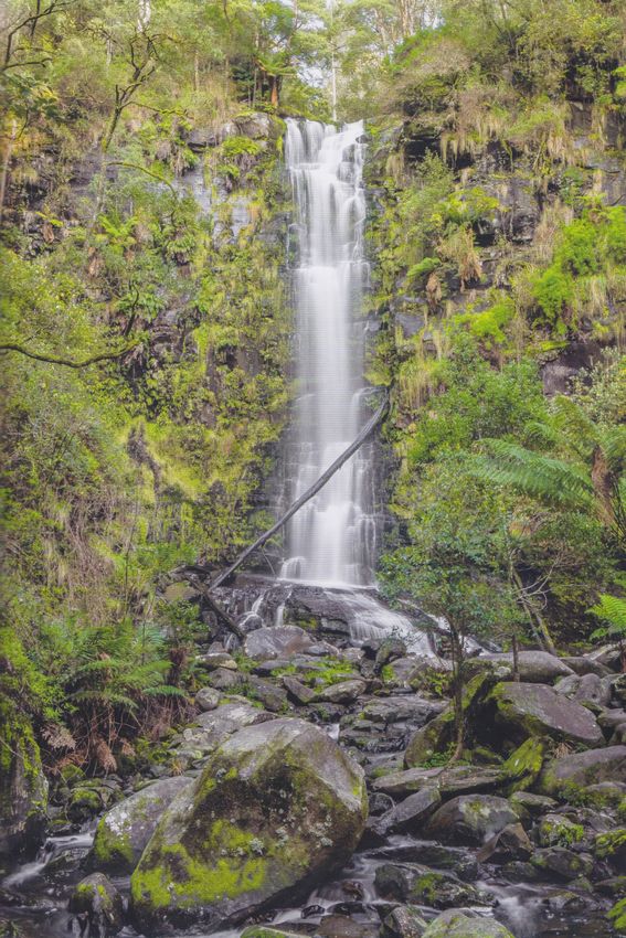
Erskine Falls (photo: the author)
His nephew, James Elphinstone Erskine (1838-1911),
was also a naval officer. As commodore of the Australian But if we’re looking for an Erskine who gave his name
station he declared the protectorate of New Guinea in to a river and a cascade in the Otways, we have to look
1884; he was later appointed Admiral and ADC to the elsewhere. James Augustus Erskine (1812-1885) was at the
king. Erskine Island, off Rockhampton, is probably centre of Melbourne’s administration in the 1840s when
named after him. the Erskine River got its name.2
continued page 3
In this issue: The Erskine River and its Falls – 1 • How Pin Pan Pa became Pimpampa – 5 •
Topoonymic slips: Bellingen – 9 • Nestled in Ovalau? – 10 • Bergen-op-Zoom – 11 • Puzzle 79: Green & Blue
From the Editor
                  In the days when I was editor on a                   Tent (on Pin Pan Pa) gives us phonetics, phonology and
                  well-known Australian dictionary,                    morphology; Paul Geraghty (on Ovalau) hits us with
                  people used to say to me ‘I just                     some detailed linguistics too. See how you go!
                  love etymologies!’ But they meant                    Anthony Car’s lead article is about history-based on
                  interesting stories about word-                      an entry in his new book on the Otway Ranges (see
                  origins, not the nitty-gritty of how                 our description on page 13). We hope to have more
                  words change over time. Well, we’re                  extracts for you in the future.          David Blair
  testing you to see which category you fall into! Jan

  Placenames in the media
  Inventing and naming the states
  We were reminded recently (9 August, Sydney Morning Herald /The Age) of
  the rather quirky suggestions of Captain James Vetch in 1838 for dividing
  Australia into 10 states. The Federation would be rather different if, 60
  years later, his ideas had been taken up. ‘Tasmania’ would be in the north,
  while the island state would still be ‘Van Diemens Land’. And ‘Guelphia’?
  his suggestion for NSW!
  We are rather taken with the idea of a special issue of Placenames Australia
  devoted to Federation and the naming of states and territories. Stay
  tuned-contributions welcome!
  Coon Island
  Lake Macquarie City Council has just recommended that Coon Island and Coon Point should be renamed. It
  is thought that the features took the name of Herbert ‘Coon’ Heaney, a coal miner. A community consultation
  revealed that 56% wanted to retain the names, but Council decided that the racist connotations were too
  strong. (A familiar story-somehow we feel we’ve been there before!) The recommendation is now with the
  NSW Geographical Names Board; we’ll keep you informed...

  Long Tunnel Creek Bridge
  Our reader Alex Allchin is intrigued by the signage for Long Tunnel Creek Bridge, near
  Junee, NSW. How does a tunnel relate to a creek? And are there many longer placenames
  than this? We thought these were good questions, and Jan Tent has researched the answers-
  his article will appear in our December issue. (Spoiler alert! - a gold mine is involved, and
  ‘bridge’ is not actually part of the placename.)

 Puzzle answers - (from page 14)
  1. Cape Bowling Green        6. Green Point                       11. Green Mountains              16. Blue Gum Forest
  2. Green Patch               7. Blue Bay                          12. Blue Cow                     17. Greenmount Hill
  3. Blue Lake                 8. Blue Mountains                    13. Blue Rock Lake/Dam           18. Green Valley
  4. Green Point               9. Big Green Island                  14. Green Bay                    19. Blue Range
  5. Blue Point               10. Blue Ridge                        15. Blue Haven                   20. Green Head

  This newsletter is published quarterly by                               Editor: David Blair
  Placenames Australia (Inc.) ABN 39 652 752 594                          PO Box 5160
  ISSN: 1836-7976                                                         SOUTH TURRAMURRA NSW 2074
                           Content from this publication is free to use under Creative Common licence cc by 4.0

2 Placenames Australia • September 2021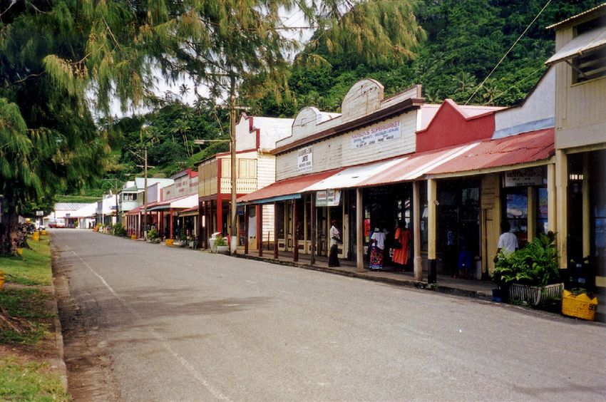
...from page 1
                                                ...The Erskine River and its Falls
Lieutenant Erskine was one of the military and naval
personnel present during George Gipps’s installation              A Favourite Victorian Seaside Resort.
as Governor of New South Wales on 24th February                                  Lorne.
1838. There is a suggestion that, as a ship’s officer, he
                                                               …The first day we were there a party determined
was involved in coastal survey work. In the early 1840s        to walk to The Erskine Falls, a distance of several
he became Deputy Assistant Commissary General                  miles. Accordingly luncheon was provided for the full
(D.A.C.G.) based in Melbourne, and in this role would          number, and the male members of the excursionists
have assisted both Governor Gipps and Superintendent           were soon loaded up. A few more preparations were
                                                               made; and finally all was arranged satisfactorily. A
La Trobe. The river at Lorne (or Loutit Bay, as it was         start was made, the party being enlivened by the
then called) was known as Erskine River by 1849:               company of a few ladies…
correspondence to Surveyor in Charge Robert Hoddle
                                                               We pushed on to our destination, gradually working
dated 26th May of that year refers to it by that name.         our way to the Erskine Falls. When those were
                                                               reached, we found ourselves amply repaid for all the
James Augustus Erskine was born on 27th March 1812             toil and trouble. Here there was a precipitous face
to Henry David Erskine and Mary Anne Erskine (née              of rock, about 120ft in height. From the summit of
Cooksey) at Warkworth in Northumberland, England.              this the waters of the Erskine Creek poured down,
Before coming to Australia he was married on 15th June         dashing over the various projections on its way to the
                                                               pools beneath, where the watercourse was heaped
1837 to Fanny Dalacombe, daughter of General Henry             with huge trunks of trees and other debris. The dark
Ivatt Dalacombe (C.B.) and Fanny Macarthur. James and          hue of the eucalypti was relieved by the bright green
Fanny had five children, all born in Melbourne: Henry          of the gigantic tree ferns, while the smooth rocks
David (1841, died first day), Augustus (1843), Caroline        formed welcome resting places for our party…
(1845), Mary Anne Craig (1847) and Emmaline                    An hour or so was spent in exploring the locality, and
(1848). Sadly, Fanny Erskine died in Melbourne on 17th         then our small force was marshalled together for the
September 1851 at the age of 34.                               homeward journey. Lorne was regained in ample
                                                               time.
Lieutenant Erskine returned to Britain and married
                                                             Not long after this, in November 1891, Rudyard Kipling
Elizabeth Bogue Brodie (born 1814) on 31st October
                                                             visited the area. His poem ‘Flowers’ references both
1852, at Fetteresso, Kincardine in Scotland. They had
                                                             Lorne and the Erskine:
10 children together. In 1866 he was granted the rank
                                                                Buy my English posies!
of an earl’s younger son and a knighthood in the Order
                                                                You that will not turn --
of St Ferdinand of Spain. He died on 24th July 1885 in
                                                                Buy my hot-wood clematis,
London aged 73. Elizabeth had predeceased him by 3
                                                                Buy a frond o’ fern
years.                                                          Gathered where the Erskine leaps
Erskine Falls are the most visited and recognised falls         Down the road to Lorne --
in the Otways. They were discovered around 1876                 Buy my Christmas creeper
by an exploration party of three Lorne residents,               And I’ll say where you were born!
W.A. Mountjoy, F.M. Straw and H. Jebb. As the first-            West away from Melbourne dust holidays begin
                                                                They that mock at Paradise woo at Cora Lynn
discovered and the most spectacular cascade on the river,
                                                                Through the great South Otway gums sings the great
they naturally became known as the Erskine Falls.
                                                                South Main
Many accounts of the trip to Erskine Falls appeared after       Take the flower and turn the hour, and kiss your love
                                                                again!
their discovery. One which represents the experience
comes from the talents of a travelling reporter expressed    The falls continued to be a subject of enthusiastic poetic
in beautiful detail on the pages of the Australian Town      description. In 1924 a full-page spread in the Melbourne
and Country Journal in 1888. The following is an extract:3   Herald encouraged tourists to visit Lorne:4

                                                                                                     continued next page

                                                                                    Placenames Australia • September 2021 3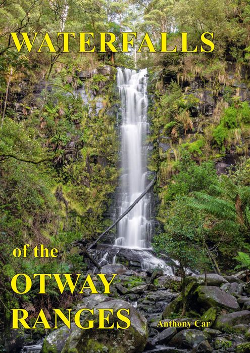
...from previous page                                                                              ...The Erskine
Lorne’s Great Attractions for Holiday Makers                  spotted galaxias or trout galaxias (Galaxias truttaceus). It
                                                              is a shame that these fish have been displaced from many
                  SCENIC BEAUTIES
                                                              of the Otway streams.
          Coastline, Bush and Waterfalls
                                                              Finally, it is worth mentioning that the Erskine River
         A LAND OF PERENNIAL ROSES                            flows into Loutit Bay, which explains why (as noted
                                                              above) Loutit Bay was the previous name of Lorne. The
    …There are 27 waterfalls of surpassing beauty
   within easy walking distance and several miles of          name was changed in 1869 in honour of the Marquis of
   tree fern gullies. Lorne is pre-eminently the land         Lorne, son-in-law to Queen Victoria. Loutit Bay has had
   of waterfalls, and their beauty is remarkably and          several spellings over the years and still has today (Loutit,
   consistently great. A popular vote would probably          Louttit, or Loutitt). The master mariner referred to by
   give first place to Erskine Falls. About 130 feet in
   height, at an elevation of nearly 1,000 feet above the     the name was Captain James Loutit. He was born in
   sea level, these falls are constant all the year round,    Walkerburn, Peeblesshire, Scotland in 1816 and married
   as indeed are most of the Lorne falls, though the          Ann Irvine Robertson on 25th May 1854 at Stromness,
   volume of water varies with the seasons. A finer           Orkney, Scotland. They had one son, James Irving Loutit,
   setting than the scenery around Erskine Falls is almost
   inconceivable, every variety of tree, shrub and fern,      born 9th May 1860. Captain Loutit died in Sydney on
   lending aid to make the picture complete.                  12th February 1870, aged 53. The last vessel under his
                                                              command was the 345-ton barque Euromedha.
It was not until the mid-1930s that discussion took place
for a road to the Erskine Falls, completed around 1937.                                                             Anthony Car
This makes it quite easy nowadays for many tourists to
                                                              Endnotes
visit the falls. However, the falls can still be visited by   1
                                                                  Blair, D. (2015). Lord Howe Island. ANPS Placenames Report, No. 3,
foot from Lorne. My son Julian has taken this path,               p. 25.
fishing along the way for trout. Trout were introduced        2
                                                                  Geelong Advertiser, 14 August 1849, p. 1. Accessed at https://trove.nla.
                                                                  gov.au/newspaper/article/93138827
into some of the streams of the Otways around 1878,           3
                                                                  Australian Town and Country Journal, 23 June 1888, p. 17. Accessed at
and more in later decades. Prior to the introduced trout          https://trove.nla.gov.au/newspaper/article/71099160
a native fish inhabited the rocky pools of the Erskine; it    4
                                                                  Herald, 18 October 1924, p. 14. Accessed at https://trove.nla.gov.au/
was referred to as mountain trout but is known today as           newspaper/article/244845326

                          The Erskine River at Lorne. (Photo: musskloproz, Wikimedia Commons)

4 Placenames Australia • September 2021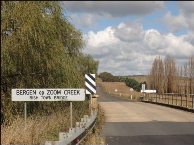
How Pin Pan Pa became Pimpampa
Many of Australia’s toponyms had various spellings          In 1861 a newspaper article2 reported the declaration
before they obtained a standardised spelling and were       of a new township to be established on Pin Pan Pa
gazetted. This is especially true of Indigenous-derived     Reserve. The name Pimpaympa was submitted, but it
placenames, because before European occupation              was not approved by the Executive Council; instead
Indigenous languages were not codified (i.e. they did       they chose the name of Maude, for reasons unknown.
not have orthographic systems, and were not written).       The township was to be situated on the north bank of
Two examples of such placenames are: Coogee (NSW—           the Murrumbidgee River, between Hay and Balranald.
Cudjee, Kudjee, Coojee, Koojah; and WA—Kou-gee,             Maude marks the traditional boundary between the
Koojee, Coojee, Kudjee), and Lake Cargelligo (NSW—          Mathi-Mathi (or Muthi Muthi/Madhi-Madhi) and Nari
Cudjallagong, Gagellaga).                                   Nari peoples. Today Pimpampa is listed in the National
                                                            Gazetteer as a parish and a homestead. And like many
The New South Wales Government Gazette record of
                                                            other toponyms I have come across, it has also been a
‘Crown Lands, within the Settled Districts’ (1852) lists
                                                            name for a racehorse—this one ran in the Melbourne
properties to be reserved from lease. One of those listed
                                                            Cup of 1880.
is the intriguingly named Pin Pan Pa (Figure 1).

    Figure 1. New South Wales Government Gazette,
  Monday 25 October 1852, No.104 (SUPPLEMENT)                      Figure 3. NSW Government Gazette (extract)
 Crown Lands Office, CROWN LANDS, WITHIN THE
 SETTLED DISTRICTS. Reserves from Lease) http://nla.        One other spelling of the toponym can be found as late
           gov.au/nla.news-article230053042                 as 1881 and 1896. The first3 is in the New South Wales
                                                            Government Gazette announcing the sale of Coonoon
However, four years before that date the New South          Point Run near the Pinpampa Run. The second,4 in The
Wales Government Gazette listed1 two claims where           Riverine Herald, reports on the arrival of wool bales at the
the property has two different spellings Pimpampa and       Port of Echuca among which were bales from Pinpampa
Pimpayinpa (Figure 2). The Pin Pan Pa reserve was taken     (Figure 3, above). These examples show that by the end
from Phelps and Chadwick’s ‘Pimpampa’ and Thomas            of the 19th century there was still no real agreement as to
Darchy’s ‘Budgee Budgee’ runs, and was to be used as the    how to spell the toponym.
site for a township.
                                                         It is interesting that Pimpampa should pre-date Pin
                                                         Pan Pa, at least in terms of it appearing in print, but
                                                                                 this does not prove the former
                                                                                 actually pre-dates the latter. It
                                                                                 is also rather surprising that the
                                                                                 spelling of the reserve should
                                                                                 differ from that of the run,
                                                                                 because it is very common
                                                                                 for such features as locations,
                                     Figure 2. NSW Government Gazette (extract)
                                                                                                    continued next page

                                                                                   Placenames Australia • September 2021 5
...from previous page                                                             How Pin Pan Pa...
townships and parishes to be named after rural properties       used for making woomeras, canoe poles and spear shafts.
without a spelling change, e.g. Khancoban (township)            Its leaves contain pinene (an antiseptic oil) and were
< ‘Khancoban’ station; Lakemba (suburb) < ‘Lakeba’,             smoked over fire or soaked to make a wash, or mixed
pronounced /laˈkɛmba/ (Benjamin Taylor’s 22 hectare             with fat to make ointment for colds.
property in 1880s named after the Fiji island of Lakeba).
                                                                Given Blake et al. cite the toponym Pinnpa, it is not so
So why was the reserve not called Pimpampa? The reason
                                                                surprising that we find Lake Pinpa (near the SA-NSW
may be found in what the local Indigenous name for the
                                                                border to the east of Lake Frome), well within the region
place might have been.
                                                                between Paakantyi and Arabana country as delineated
All evidence suggests the name derives from the Paakantyi       by Hercus (1989). Intriguingly, there is also a Pine Dam
language and its various dialects (including Berri-ait or       closer to the SA-NSW border, as well as a Pine Creek
Parintji, a southern variety of Paakantyi) spoken adjacent      further south along that border, both suggesting the
to Mathi-Mathi country. Hercus (1989, p. 51) notes              abundance of cypress pines in the region. Manning
pinpah as the Berri-ait word for ‘pine tree’; pinpa is the      (2012) notes that Pinpa is ‘Aboriginal for “native pine”
corresponding form in the other Paakantyi dialects, as far      – many pines grow on the lake’s western side.’ He also
west as Arabana country (in SA, on the western side of          lists Pimba ‘A railway station on the Trans-Australia line,
Lake Eyre to Oodnadatta and Coober Pedy).                       176 km North-West of Port Augusta. The Pimba School
                                                                opened in 1948 and closed in 1951. Aboriginal for “pine
Blake et al. (2011) catalogue placenames along the
                                                                trees”.’7 Other locations with Indigenous cognate names
Murrumbidgee River from the junction of Lachlan to
                                                                for ‘pine tree(s)’ in Manning’s compendium are:
the junction of the Murray. The names are cited from
the very detailed map produced in the survey of the               Pimbaacla - A railway station 93 km east of Ceduna.
                                                                  Aboriginal for ‘many pine trees’. The Pimbaacla School
Murrumbidgee River by the surveyor Francis MacCabe                opened in 1936 and closed in 1947.
in 1849.5 On his map he recorded up to 6-8 Indigenous             Pimbanyerta - Shown on a map prepared by J.B. Austin
placenames every mile or so along the river. Blake et al.         in 1863; corrupted to ‘Benbonyathe’.
presume that the names refer to places within the Mathi-          [Benbonyathe Hill - In the Gammon Ranges (North
                                                                  Flinders), derived from the Aboriginal words pimbanyerta
Mathi area. See Table 1 (below).                                  and abna – ‘native pine high ground’.]
                                                                  Bimbornina Hill - Aboriginal for ‘pine tree hill’.
 Placename Location         Run   Source6 Comments
                                                                  Bimbowrie - Derived from an Aboriginal word pimbawi
 Pinnpa       Due west            McC     This looks exactly      meaning ‘pine tree water’ and applied to Bimbowrie Hill,
              of Gundi,                   like pinpa, the         north of Olary.
              sth side of                 word for ‘Murray        Pimpala - A railway station near Reynella. Pimpala School
              river.                      pine’ in all            opened in 1975. Aboriginal for ‘place of native pines’.
                                          Paakantyi dialects,
                                          and over a vast
                                          area beyond, but
                                          in Wemba-Wemba
                                          the ‘Murray Pine
                                          is marrung and
                                          in Mathi-Mathi
                                          marrinhi. It could
                                          well be a borrowed
                                          placename

  Table 1. Reproduced section of Table 28, Blake et al
                    (2011, p,50)

The Murray pine (or white cypress pine, Callitris
glaucophylla, Callitris gracillus ssp Murrayensis) is found
                                                                 Figure 4. The approach to Pimba, near Woomera SA.
on sand hills along the Murray River (Local Land
                                                                  (Source: http://traveloutbackaustralia.com/driving-
Services Western Region, 2016, p. 11). It provided
                                                                         from-adelaide-to-alice-springs.html)
valuable resin for waterproof adhesive and its wood was

6 Placenames Australia • September 2021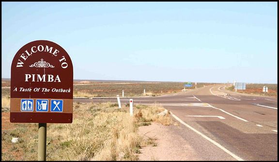
...became Pimpampa
In addition to these toponyms, the South Australian         to places far away from their origins has been common
Gazetteer Property Location Browser8 also records           among settlers. Phelps and Chadwick’s Pimpampa may
Urupinpanya Creek and Urupinpanya Rockhole, north-          well be another example of this practice. The copying and
west of Coober Pedy and west of Marla respectively. No      ‘displacing’ of Indigenous names makes it difficult, and
further information is provided. Nevertheless, both names   often impossible, to determine their origins and meanings.
are suggestive of being cognates with the above examples.
                                                            So how can we explain the change from Pin Pan Pa
The abundance of pines in the south-western region of       to Pimpampa? Good old fundamental phonetics,
NSW was noted on several occasions in the journals9         phonology and morphology provide the solution. It is
of William John Wills and Ludwig Becker during              most likely a simple case of assimilation-that is, sound
their traversing of the Balranald district in September     change due to the influence exercised by one sound
1860, and was noted on a ‘Sketch of route from              segment A upon the articulation of a neighbouring
Balranald to Scot’s station, roughly drawn by dead          sound B: this results in B becoming more like, or even
reckoning’, 25 September, 1860 (Becker, 1860): ‘The         identical to, A. Assimilation is one of the means by
whole country a sandy loam, the greater part covered        which fluency and rhythm are maintained in natural
with Casuarina, Mallee Pine, stunted eucalypt etc;          speech, and occurs intuitively in all languages. For
[…].’ Ryan (2014, p. 303) also notes that early maps        example, in the phrase ten bikes, the natural form in
of the region show that Murray pines were plentiful.        spoken colloquial speech would be /tɛm baɪks/ not /tɛn
                                                            baɪks/, which would sound somewhat ‘careful’. The /n/
                                                            has come under the influence of the following /b/ and
                                                            has adopted /b/’s bilabiality (i.e. articulation employing
                                                            both lips), thus becoming /m/. Sometimes these natural
                                                            changes in articulation become reflected in the spelling.
                                                            An example of this, where an /m/ becomes an /n/, can
                                                            be seen in the word ant. In Old English its form was
                                                            æmete, but by the 17th century had become ant, because
                                                            over time the middle vowel had been deleted and the
                                                            resulting places of articulation for the now contiguous
                                                            /m/ and /t/ were too dissimilar, resulting in the /m/
                                                            becoming /n/ to mirror the place of articulation of /t/.

                                                            However, you may well ask: ‘If pinpa/pimba is the word
                                                            for ‘pine tree’ where does the extra syllable in Pin Pan Pa
                                                            and Pimpampa come from, and what does it mean?’10
                                                            I have not been able to come to a definite conclusion.
                                                            However, several possibilities may be hypothesised.
                                                              1.   An earlier form (e.g. Pinpayinpa) had the extra syllable
                                                              and was lost over time.
    Figure 5. Murray cypress pines. (Source:                  2.     The final -pa may be a filler commonly used to avoid
        wikidata.org/wiki/Q7177505)                           a final consonant. But therein lies a problem: where does
                                                              the -n, -yin, or -yn/ym come from? Perhaps the original was
Nevertheless, it must be noted that Pin Pan Pa/Pimpampa       pinpan or pinpany/pinpayn and in one language the nasal was
is in neighbouring Mathi-Mathi country, where the             dropped.
word for the Murray pine is marrinhi/marini (Hercus,          3.    The middle syllable is a reduplication (i.e. a repetition)
1986, p. 224). This is not a problem, however, because it     indicating the plural. Support for this could lie in what
could well be a copied placename. Indeed, the practice of     Hercus (1986, pp. 26-27) writes about the expression of
                                                              number in the Wembawemba language (a neighbouring
copying Australian Indigenous names and applying them
                                                                                                       continued next page
                                                                                     Placenames Australia • September 2021 7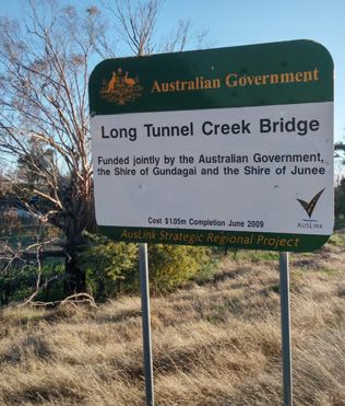
...from previous page                                                                                         ...Pin Pan Pa
   language to Mathi-Mathi and Parintji). She explains there         the distinction between non-Pama-Nyungan (NPN) and
   are five ways to express number, three of which seem to be of     Pama-Nyungan (PN) languages. NPN have prefixes and
   most interest to us:
                                                                     suffixes, whereas PN languages just have suffixes. Since
     (a) A plural can be formed by repetition of the word.
     This method was not used frequently and appeared to be          these two toponyms occur in the middle of SA, they are
     confined to inanimate objects: e.g. /maruŋ/ ‘Murray pine’       PN languages and this would suggest that  is not
     (Callitris columellaris)...   /maruŋ-maruŋ/ ‘a forest of        a prefix.
     Murray pine’.
     (b) There is a specialised form of the plural (based on         All the above is plausible, but speculative. I shall conclude
     internal reduplication). This was attested only in one word:    with the very apt observation of Hercus (2002: 63):
     /baiŋgug/ ‘child’, plural /bembeŋgug/.                                There are few topics as challenging as the study of Australian
     c) The postpositional forms /-bula/ and /-bara/ were used             [indigenous] placenames. Their formation varies from region
     for the dual and plural respectively[…] The plural marker             to region, they may be analysable or not, they may refer to the
     /-bara/ is not a true postposition, it is also an independent         actions of Ancestors, they may be descriptive, or ‘indirectly’
     noun of quantity, and was generally associated with the               descriptive […]. We can also never be sure we are right about a
     possessive affix /barug/. Thus /barug wile/ was heard as well         placename unless there is clear evidence stemming from people
     as /wile-bara/ ‘a lot of possums’, but both these expressions         who have traditional information on the topic. In the absence
     were distinctly emphatic. /marug/ and /lambrug/, both                 of such evidence we have to admit we are only guessing.
     meaning ‘many’, generally preceded the noun which they
     qualified – /lambrug wile/ ‘many possums’. None of these        Unfortunately, the latter is too often the case.
     methods of expression was common; the plural with /-bara/
     was perhaps the most usual.                                                                                                    Jan Tent
Hypothesis 3 seems to be the most feasible, and if                   Acknowledgment: Many thanks to Barry Blake for the valuable
                                                                     reference and comments. Also a big thank you to Michael Walsh
accepted we can create a scenario illustrating the
                                                                     for his suggestions on the formation of Pimpampa.
formation of Pinpampa. It would go something like this:
      pinpa ‘pine’ > pinpinpa ‘pines’ [partial reduplication] >
                                                                     Endnotes
                                                                      1
                                                                           New South Wales Government Gazette of Wednesday, 27 September,
     pimpimpa [assimilation] > pimpampa [vowel harmony]11                 1848 [Issue No.109 (Supplement)] ‘Claims to Leases of Crown Land
                                                                          Beyond the Settled Districts. Lachlan District’.
There is one caveat to this scenario: the extent to which             2
                                                                          ‘Lower Murrumbidgee’. Sydney Morning Herald, 15 April 1861, p. 2.
vowel harmony occurs in the language areas of interest               3
                                                                          New South Wales Government Gazette of Monday 25 April 1881 [Issue
is currently unknown. Vowel harmony is not all that                       No.171 (Supplement)] ‘Sale at the Land Office, Hay, Wednesday, June
common in Australian languages; however, Yallop (1982,                    1, 1881. Country Lots’.
                                                                      4
                                                                          The Riverine Herald of Friday 18 September, 1896, p. 2.
p. 68) notes that a few Australian languages exhibit
                                                                     5
                                                                           MacCabe Corner is the point at which the borders of the states of
limited application of it. Two notable examples are the                   South Australia, Victoria and New South Wales meet, and was named
Northern Territory languages Warlpiri and Jingulu. It                     after Francis MacCabe.
has also been noted to some extent in other languages                6
                                                                          McC = ‘MacCabe’. No bibliographic details are provided for this source
along the continent’s northern periphery: Worrorra                   7
                                                                          As early as 1908, Cockburn (1990 [1908]: 175-176) lists Pimba and
                                                                          Pimbaacla as railway sidings with the meaning of ‘(many) pine trees’.
(WA) (Clendon, 2014); Guugu Yimidhirr (QLD)                          8
                                                                          http://maps.sa.gov.au/plb/
(Haviland, 1979); Anguthimri (QLD) (Crowley, 1981);                  9
                                                                          http://www.burkeandwills.net.au/index.php
and Djapu (a Yolngu dialect, NT) (Morphy, 1983). It                  10
                                                                           The extra syllables following pimba in the SA toponyms most likely
has even been noted, by Steele (2005, p. 142), to have                    indicate number, ‘hill’, ‘high ground’, ‘water’ and ‘place of ’.
a limited presence in Biyal-Biyal (a language of Sydney).            11
                                                                          ‘Vowel harmony’ refers to long distance assimilation of vowels. In other
                                                                          words, vowels in successive syllables must agree in certain features, for
One small issue remains regarding the two SA toponyms                     example, a word cannot contain both front and back vowels, or both
                                                                          rounded and unrounded vowels.
Urupinpanya Creek and Urupinpanya Rockhole. I have
not been able to ascertain the meaning of the specific
element. If the  element refers to ‘pine’, then            References
                                                                     Becker, L. (1860). Ludwig Becker sketchbook. The Royal Society
 looks to be a prefix. However, Australian languages             of Victoria Collection: State Library of Victoria. Accession No.
are of two types—prefixing and non-prefixing, though                  H16486
there is considerable overlap between these terms with               Blake, B. J. (2011). Dialects of Western Kulin, Western Victoria:

                                                                                                                         continued next page
8 Placenames Australia • September 2021
Toponymic slips of the pen
Some of our best friends here at the Survey are                           water’, ‘winding river’, ‘quoll, or even ‘cheeky fellow’. It
cartographers, surveyors and sundry editors-and far                       was originally spelled Billingen on Hodgkinson’s map,
be it from us to feel superior when it comes to matters                   but Billengen, Bellengen and Bellingen were also used later
of accuracy and transcription. We’ve made bloopers of                     on.
our own from time to time. However... We recall noting
                                                                          Sweeney and Snyder claim the origin of Bellinger derives
recently how a surveyor’s ‘rivulet’ in the Blue Mountains
                                                                          from the fact that ‘...a draughtsman who was compiling
became the River Lett through an editor’s assiduous
                                                                          the Colony map from original documents misread
interpreting (September 2017 issue). And now Jan Tent
                                                                          Hodgkinson’s final handwritten ‘n’ as an ‘r’...’ Thus the
has drawn our attention to another editorial slip.
                                                                          Bellingen River officially became the Bellinger.
The Bellinger River runs through the town of Bellingen
                                                                          The river, and now the town, are in Gumbaynggirr
in NSW. What accounts for this seeming inconsistency?
                                                                          country, and the Indigenous name for the region is
The answer was easy to find, thanks to the Bellingen and
                                                                          Baligin / Baalijin or Baliijin. According to Sweeney
Urunga Museums website. The article ‘Origins of the
                                                                          and Snyder, this is also the Gumbaynggirr name for the
name Bellingen’ (Sweeney & Snyder, 2014) holds the
                                                                          marsupial known as the eastern quoll.
answer.

The Government Surveyor, Clement Hodgkinson,
                                                                          Reference
whilst surveying the area in 1841, bestowed the local
                                                                          Sweeney, J. & Snyder, S. (Eds.). (2014). Origins of the name Bellingen.
Indigenous-derived name Bellingen to the river. Its                        Bellingen and Urunga Museums. http://www.bellingenmuseum.org.au/
meaning is not really known and is said to mean ‘clear                     articles_type/origins-of-the-name-bellingen

...Pin Pan Pa
  Yartwatjali, Tjapwurrung, Djadjawurrung. La Trobe                        origin in Australia (pp. 63-72). Canberra: ANU Press &
  University.          http://www.vcaa.vic.edu.au/documents/alcv/          Pandanus Books.
  dialectsofwesternkulin-westernvictoria.pdf                              Local Land Services Western Region (2016). Ecological cultural
Blake, B. J., Hercus, L. A., Morey, S. & Ryan, E. (2011). The              knowledge - Paakantji (Barkindji) and Maraura (Gerard):
  Mathi group of languages. Pacific Linguistics, PL-628. Canberra:         knowledge shared by the Paakantji and Maraura people (Lake
  The Australian National University.                                      Victoria).           https://western.lls.nsw.gov.au/__data/assets/
Clendon, M. (2014). Worrorra: A language of the north-west                 pdf_file/0004/737626/Paakantji_Maraura_Booklet_WEB-
  Kimberley coast. Adelaide: University of Adelaide Press. https://        updated.pdf
  www.adelaide.edu.au/press/titles/worrorra/worrorra-ebook.pdf            Manning, G. H. (2012). A compendium of the place names
Cockburn, R. (1990 [1908]). South Australia: what’s in a name?             of South Australia from Aaron Creek to Zion Hill with
  Authoritative derivations of some 4000 historically significant place    54 complementary appendices. http://www.slsa.sa.gov.au/
  names. Stepney, SA: Axiom Publishing.                                    digitalpubs/placenamesofsouthaustralia/
Crowley, T. (1981). The Mpakwithi dialect of Anguthimri. In               Morphy, F. (1983). Djapu, a Yolngu dialect. In R.M.W. Dixon
  R.M.W. Dixon & B. J. Blake (Eds.). Handbook of Australian                & B. J. Blake (Eds.). Handbook of Australian languages (Vol. 3,
  languages (Vol. 2, pp. 147-196). Canberra: The Australian                pp. 1-190). Canberra: The Australian National University Press.
  National University Press.                                              Ryan, E. J. (2014). Water for country, words for water: Indigenous
Haviland, J. (1979). Guugu Yimidhirr. In R.M.W. Dixon & B.                 placenames of north-west Victoria and south-west New South
  J. Blake (Eds.). Handbook of Australian languages (Vol. 1, pp.           Wales. In I. D. Clark, L. Hercus & L. Kostanski (Eds.).
  27-182). Canberra: The Australian National University Press.             Indigenous and minority placenames: Australian and international
                                                                           perspectives (pp. 293-304). Canberra: ANU Press.
Hercus, L. A. (1986). Victorian languages: a late survey. Pacific
  Linguistics, Series B - No.77                                           Steele, J. M. (2005). The Aboriginal language of Sydney: a partial
                                                                           reconstruction of the Indigenous language of Sydney based
-----. (1989). Three linguistic studies from far south-western New
                                                                           on the notebooks of William Dawes of 1790-91, informed
  South Wales. Aboriginal History, 13(1), 45-62. http://press-files.
                                                                           by other records of the Sydney and surrounding languages to
  anu.edu.au/downloads/press/p72111/pdf/article037.pdf
                                                                           c.1905. Master of Arts (Research) Thesis. Macquarie University.
-----. (2002). Is it really a placename? In L.A. Hercus, F. Hodges
                                                                          Yallop, C. L. (1982). Australian Aboriginal languages. London:
  & J. Simpson (Eds.). The land is a map: placenames of Indigenous
                                                                           André Deutsch.

                                                                                                      Placenames Australia • September 2021 9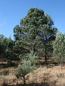
Nestled in Ovalau?                                                     Placenames of Fiji - 17
In the previous issue of Placenames Australia, I left you
with a bit of a cliff-hanger. We had been discussing
the island of Ovalau in the province of Lomaiviti, the
sixth largest island in Fiji and site, until 1882, of the
nineteenth-century capital Levuka. I had proposed
plausible etymologies for Levuka, Lovoni, in the centre
of the island, and Moturiki, the island to the south.
However, I admitted that the etymology of Ovalau
itself is something of a problem. It clearly has two parts,
and the latter segment, lau, equally clearly means ‘east’
or ‘seawards’, since it has that meaning in many other
placenames in Fiji and the Pacific, and is apt for an island               Beach Street, Levuka, on Ovalau
lying east or seawards of the great land-mass of Vitilevu.                    (photo: Wikimedia commons)
But the meaning of the first segment, ova, is elusive: it      by adding a suffix -a, optionally preceded by one of a
doesn’t mean, nor has it ever meant, ‘land’ or ‘island’,       small number of consonants, and that such nouns often
so I must move into the realm of speculation, confident        became placenames. So, for example, tavu meant ‘burn’
nonetheless that I will not be the first toponymist to have    and tavua meant ‘burning place’ or ‘volcano’; it was the
done so!                                                       name given to a number of places in Fiji, as well as Tafua
                                                               in Samoa and Tofua in Tonga, because they were active
My best guess is as follows. Recall that the two large
                                                               volcanoes, or somehow volcanic in appearance. Similarly,
islands of Lomaiviti we have already studied are named
                                                               namu meant ‘mosquito’, so places that abounded with
after their general shape-Gau meaning something
                                                               mosquitoes were named Namuka in Fiji, Nomuka in
like ‘log’ or ‘trunk’, befitting its solid bulky profile,
                                                               Tonga and Namu’a in Samoa.
contrasting with Koro meaning ‘mountainous’, telling of
its ruggedness. So my speculation is that the name of          When this process was applied to the verb ō meaning
Ovalau (or Naova, in some cultural contexts) was also          ‘brood’, it yielded ova meaning ‘brooding place, nest’.
based on its distinctive shape, which as already noted is      This word has disappeared in eastern Fiji, but it is still
that of a mountainous rim surrounding a caldera, at the        used in the northwest, in places such as the Yasawa
centre of which is the valley of Lovoni.                       Islands, Vuda and Ba. In some Polynesian languages, a
                                                               similar bisyllabic suffix was applied, yielding the word
My proposal is that the names Ovalau and Naova derive
                                                               ōfaga ‘nest’ in languages such as East Futunan, Samoan
ultimately from a word for ‘nest’, which the island
                                                               and Niuean.
resembles in shape. (Na- is the Fijian article, hence ‘the
nest’.) Now ova is not the Standard Fijian word for            It is indeed curious that the word for ‘nest’ in parts of
‘nest’-which is sova-so I will attempt to argue that ova       eastern Fiji is sova, very similar to ova, but there is no
was the word for ‘nest’ three thousand years ago, when         regular historical process that can be invoked to account
the island was named.                                          for such a change. It is also the name of a large kind of
                                                               wicker basket, and may well have become an element in
To do this, I start with the claim that for the Lapita
                                                               placenames, meaning ‘a bay’; it is conceivably the root of
people, who spoke a language we now call Proto
                                                               the placename Nasova, a small bay just south of Levuka
Central Pacific, there was a verb ō, meaning ‘brood’,
                                                               on Ovalau which was the site of the signing of the Deed
in the sense of ‘sit on eggs’. This word is still used in
                                                               of Cession in 1874, by which Fiji became a Crown
parts of both western and eastern Fiji, and in Polynesian
                                                               Colony, and was the residence of the earliest Governors.
languages such as East Futunan. Now, those among you
                                                               So the historical site Nasova may have ultimately the
who have been following this column for a long time
                                                               same etymology as the island on which it is situated,
may recall that a number of years back I pointed out
                                                               Naova ‘the nest’ or Ovalau ‘eastern/seaward nest’.
that the language of the Lapita people had a regular
process of forming nouns from verbs (or other nouns)                                                 Paul Geraghty

10 Placenames Australia • September 2021
Bergen-op-Zoom
I thought I was quite familiar with most Dutch and north of Antwerp, in the province of North Brabant.
Dutch-linked toponyms in Australia, but there are always The city was built on what is known as the Brabantse
ones hiding in the undergrowth waiting to be discovered. Wal [‘Brabant Ridge’], an abrupt geological transition
One such is Bergen-Op-Zoom (pronounced locally as / forming a steep ridge between higher sandy soils and
ˈbɜgən ɒp ˌzuːm/) in the LGA of Walcha on the south- lower lying marine clay. The ridge was produced by
eastern edge of the Northern Tablelands, NSW. The erosion caused by the river Scheldt; ejection by the
traditional owners of the land are the Dhanggati people. sea and run-off water may also have played a role.1 It
It was the conversation David Blair had with the author forms the transition between two geological eras—the
of the Historical Guide to New South Wales, Phillip Pleistocene and the Holocene—and has a maximum
Simpson (Placenames Australia, June 2021), that alerted height of 22 meters. Zoom refers to the ‘seam’, ‘edge’ or
me to this toponym’s existence. ‘border’ of the ridge. The Dutch etymological dictionary,
the Woordenboek der Nederlandsche Taal (WNT),2 cites
I have not been the first to be surprised at the existence of the earliest written attestation of the toponym as 1289.
a Bergen-Op-Zoom in NSW. The author of a short article
in the Dutch Australian Weekly of Friday 5 April 1963 The NSW Geographical Names Board provides the
(p. 2) was perplexed by the existence of the name and following information on origin of the name:
asked if any readers could enlighten the newspaper of its Named after the property through which the creek runs. One
of the very early original sheep runs in the Walcha District, it
origin. A later incarnation of this weekly newspaper, the
was taken up in 1834 by Capt John McLean from Scotland. It
Dutch Weekly, also ran a very short piece on the name (24 is believed that it commemorates his ancestors exploits whilst
May 2004, p. 18), once again expressing surprise at its engaged with the Dutch in defence of Bergen op Zoom in
existence in Australia, and hazarding the wild guess that 1747. (Walcha Historical Society)
a Dutch farmer may have been the source of the name. The entry also notes that although the toponym was
However, a Mrs L.C. Davidson had already replied to the hyphenated when adopted in 1834, and is still so
Dutch Australian Weekly (3 May 1963, p. 9), where she represented in the gazetteer, modern signposting renders
revealed the origin of the toponym by citing Campbell the name in an unhyphenated form (see Figure 2, over).
(1922).
It is not clear whether John McLean was a Captain (either
The Gazetteer of NSW lists a Bergen-Op-Zoom Creek in the military or in maritime services). Campbell (1922,
and a Bergen-Op-Zoom parish. Like so many other p. 260), who provides a short biography of McLean,
geographic features, they take their name from a pastoral includes the rank but post-modifies it with a question
run. The creek is situated along the Oxley Highway mark. All other references I have found regarding
east of Tamworth and west of the town Walcha. The McLean do not mention this rank, so the available
name derives from the Dutch city Bergen op Zoom evidence suggests he was not a Captain.
(/ˈbɛrɣə(n) ɔp ˌsoːm/) [lit. ‘Hills on the Seam/Edge’] just
Figure 1. The Brabantse Wal [‘the Brabant Ridge’] (Source: Wikimedia Commons)
continued next page
Placenames Australia • September 2021 11...from previous page
Bergen-op-Zoom...
front in the Austrian Empire’s struggle with France
during the War of the Fifth Coalition (Howard, 2012;
Yonge, 2018). Walcheren lies just to the west of Bergen
op Zoom.
Accordingly, there were three occasions when the British
joined the Dutch forces against the French, once in
1747, then again in 1809 and 1814.
Belshaw (2020) also recounts this origin and the apparent
connection between Allan and Francis McLean and the
naming of John McLean’s 44,800 acre run. However,
Belshaw omits to mention in which campaign the
McLeans were engaged.
Figure 2. The Irish Town Bridge (Source: https://indebuurt.
The question one has to ask is: ‘On which occasion
nl/bergenopzoom/genieten-van/mysteries/bergs-mysterie-
did John McLean’s relatives fight in Bergen op Zoom?’
bergen-op-zoom-buitenland~26600/)
Campbell (1922, pp. 260-261) provides the answer
The Newcastle Sun (28 August 1953, p. 4) ran a story (though not definitively) in his article ‘Discovery and
that echoes the GNB’s statement of origin: early pastoral settlement of New England’ when he
[...] In 1834 a man named McLean followed and took up a
holding to the north of Walcha which he called ‘Bergen-op-
presents biographical sketches of southern New England
Zoom’ in honor of his ancestors, Allan and Francis McLean, pioneer squatters:
who were helping the Dutch to defend the city of that name John McLean, familiarly called ‘Jock’ McLean, by his confreres,
in 1747 against the French. They put up a great fight, but did arrived in Sydney on or about March 17, 1829, and settled on
not win the battle and were taken prisoners by the French, the Williams River, Hunter district. He evidently belonged to
who sportingly gave them parole for their gallantry. (From the the McLeans of the Isle of Mull, Scotland, and the name of his
records of Mr. W. Goold.) New England occupancy, Bergen-op-Zoom, would suggest a
reminder of the exploit of his relatives while engaged with the
The Wikipedia article on Walcha echoes this origin, but Dutch in defence of that city in 1747.
differs in one significant fact (and adds a spelling error):
[...] in 1834, John McLean took up a run he called Bergen op
More detailed intelligence is supplied by Stanley (1979)
Zoom, reportedly named in tribute to relatives Allen [sic] and and Wickwire (1979).3 Both Allan and Francis have
Francis McLean, who had assisted the Dutch in the defence of entries in the Dictionary of Canadian Biography. Stanley’s
that town against the French in the War of the Sixth Coalition. entry for Allan states the following:
Like many of his Highland contemporaries, Allan Maclean
The War of the Sixth Coalition was one of the Napoleonic joined the Jacobite army in 1745. He served as a lieutenant
Wars and occurred between March 1813 and May 1814. in the Clan Maclean battalion and was present at Culloden.
During this war Bergen op Zoom was besieged by the After the defeat of Charles, tire Young Pretender, Maclean fled
British in a failed attempt to dislodge the French garrison to the Netherlands and enlisted in the Scots brigade of the
Dutch army in May 1746. In 1747 he and his kinsman Francis
there. McLean were captured by the French at the siege of Bergen
op Zoom (Netherlands). Allan Maclean returned to Great
The Walcha Visitor Information Centre’s website has a Britain in 1750 following the amnesty granted by George II
page on the town’s early history (https://walchansw.com. to all Jacobite officers willing to swear allegiance to the house
au/portfolio/history/) provided by the Walcha District of Hanover.
Historical Society. It claims the name Bergen-Op-Zoom
So, there we have it: it was in the 1747 war, and the
was well-known ‘to the early settlers because of a major
evidence suggests that McLean named his run in honour
campaign of 1809 called the Walcheren Expedition,
of his relatives’ role in that war.
fought during the British wars with Napolean [sic].’
This was an unsuccessful British expedition to the Dutch Campbell (1922, pp. 261-2) recounts that John McLean
island of Walcheren in 1809 intended to open another was unfortunate in his speculative transactions:
12 Placenames Australia • September 2021...Bergen-op-Zoom
[...] and whilst struggling against these misfortunes he, like
many others, was overtaken by the bad times of the forties.
Evidently disheartened by the prospects of bankruptcy, [...],
McLean on October 22, 1843, tragically terminated his life
at Port Macquarie while on his journey from Sydney to New
England.
The Sydney Morning Herald reported McLean’s death in
November 1843 (Figure 3).
Although there does not seem to be any documentary
evidence showing the circumstances of McLean’s
naming his pastoral run ‘Bergen-op-Zoom’, anecdotal
evidence suggests it was named to honour his two
relations Allan and Francis.
Jan Tent
Endnotes
1
Stichting de Brabantse Wal, https://brabantsewal.nl;
Geologie van Nederland, https://www.geologievannederland.nl/
landschap/landschapsvormen/steilranden;
van Berkel & Samplonius 2006:19
2
This is the Dutch equivalent to the Oxford English Dictionary on Figure 3. Report of John McLean’s death, Sydney Morning
Historical Principles.
Herald, 2 November 1843, p. 4
3
Notice that Stanley spells Allan’s surname MacLean. All other instances
of the surname are spelled McLean.
Howard, M.R. (2012). Walcheren 1809: Scandalous destruction of a
References British Army. Barnsley, South Yorkshire: Pen and Sword.
Belshaw, J. (2020). Building dynasties in New England. New England’s Stanley, G.F.G. (1979). MacLean, Allan. Dictionary of Canadian
History—Discussions on the history and historiography of Australia’s New Biography, Vol. 4. University of Toronto/Université Laval. http://www.
England. https://newenglandhistory.blogspot.com/2020/02/building- biographi.ca/en/bio/maclean_allan_4E.html (accessed 14 May 2021).
dynasties-in-new-england.html (accessed 15 May 2021) van Berkel, G. & Samplonius, K. (2006) Nederlandse plaatsnamen:
Campbell, J.F. (1922). Discovery and early pastoral settlement of New Herkomst en historie. [‘Dutch placenames: Origins and history’]. 3rd
England. The Royal Australian Historical Society. Journal and Proceedings, Ed. Utrecht: Het Spectrum.
8(5), pp. 225-288. https://nla.gov.au:443/tarkine/nla.obj-595105154 Wickwire, F.B. (1979). McLean, Francis. Dictionary of Canadian
(accessed 14 May 2021). Biography, Vol. 4. University of Toronto/Université Laval. http://www.
Davidson, L.C. (1963). Bergen-op-Zoom raadsel is opgelost: De biographi.ca/en/bio/mclean_francis_4E.html (accessed 14 May 2021).
McLeans vochten tegen de Fransen. [‘Bergen-op-Zoom mystery Yonge, I (2018). The Walcheren Expedition of 1809. The Waterloo
has been solved: The McLeans fought against the French’]. Dutch Association. https://www.waterlooassociation.org.uk/2018/06/22/
Australian Weekly, Friday 3 May, 1963. http://nla.gov.au/nla.news- walcheren-expedition/ (accessed 14 May 2021).
article218828260 (accessed 15 May 2021).
Waterfalls of the Otway Ranges
The source of this month’s lead article by Anthony Car is his newly-published Waterfalls
of the Otway Ranges. It documents the nature and history of 226 waterfalls in the Otways,
and is lavishly illustrated by historical photos and by Anthony’s own photography. The
book has detailed maps, with suggestions on which waterfalls to visit. (You probably
wouldn’t want to carry it with you: it’s not a small volume-321 pages and nearly 2kg!)
We heartily recommend it for its detailed records of this aspect of Victoria’s landscape.
You can pick up a copy at various bookshops in the Ranges, or order online ($55) from
bookstores such as the Paperback Bookshop or Great Escape Books.
Placenames Australia • September 2021 13Placenames Puzzle Number 79
Green & Blue
Green and blue are the colours embedded in this issue’s
quiz. Example-(TAS) A sweet hill east of the town of
Ross in the Midlands: Answer: Green Sugarloaf
1. (QLD) The longest spit in Australia, 30 kilometres 11. (QLD) A mountain range, part of the Lamington
from Ayr, named by James Cook. National Park.
2. (Jervis Bay Territory) A picnic area and camping 12. (NSW) A ski field at Perisher Ski Resort.
site within Booderee National Park. 13. (VIC) A lake/dam NNE of Moe.
3. (SA) A lake in Mt Gambier. 14. (SA) A small cove north-east of Victor Harbor.
4. (NSW) A south-eastern suburb of the Central 15. (WA) A small beach south-west of Esperance.
Coast region, adjacent to Brisbane Water. 16. (NSW) A forest near Blackheath.
5. (NSW) A small peninsula in Bermagui. 17. (QLD) A knoll on Point Danger (Coolangatta)
6. (TAS) A peninsula on the far north-eastern coast. that can’t quite make up its mind what it is.
7. (WA) A cove west of Mandurah. 18. (NSW) An outer-western suburb of Sydney just
8. (NSW) A mountain range west of Sydney. east of the M7 motorway.
9. (TAS) A small island with a rather grandiose name 19. (VIC) A range NNE of Marysville.
off the west coast of Flinders Island. 20. (TAS) A headland on the tip of the Tasman
10. (ACT) An elevation due west of Canberra on the Peninsula.
NSW border. [Compiled by Jan Tent
Answers on page 2]
Become a Supporting Member!
We realise that not everyone who wishes to support the Australian National Placenames Survey can do so by carrying out
toponymic research and supplying information for our database. There is another way — become a supporting member
of Placenames Australia! In doing so, you’ll help the Survey and its volunteer researchers by providing infrastructure
support. In return, you'll have the assurance that you’ll be helping ensure the continued existence of this prestige
national project, and we’ll guarantee to keep you in touch with our progress.
Please consider carefully this invitation. If you wish to become a Member
q send a cheque for $25 to Placenames Australia Inc.
q or arrange a bank transfer for $25 to bsb 032089 a/c 275989
Please advise our Treasurer of the transfer by one of the following methods:
Email: treasurer@anps.org.au
Mail: PO Box 5160, south turramurra nsw 2074
Website: www.anps.org.au
Articles for Placenames Australia
Material for publication in Placenames Australia is always welcome. Please send all contributions to the Editor, David Blair, by email:
Supporting photographs or other illustrations are greatly appreciated.
Closing dates for submissions are:
March Issue: 15 January June Issue: 15 April September Issue: 15 July December Issue: 15 OctoberYou can also read


