THE DRAWING AS A GUIDE BETWEEN THE STUDY AND THE INTERVENTION. THE CASTLE OF ORBA (ORBA-MURLA, ALICANTE. SPAIN) - PoliPapers
←
→
Page content transcription
If your browser does not render page correctly, please read the page content below
EGE - Revista de Expresión Gráfica en la Edificación, Nº 14, 2021. ISSN: 2605-082X
                                                                    https://doi.org/10.4995/ege.2021.15728
                                                                                                 APEGA, UPV

        THE DRAWING AS A GUIDE BETWEEN THE STUDY AND THE INTERVENTION. THE
                                CASTLE OF ORBA (ORBA-MURLA, ALICANTE. SPAIN)

EL DIBUJO COMO GUIA ENTRE EL ESTUDIO PREVIO Y LA INTERVENCION. EL “CASTELLET”
                                     DE ORBA (ORBA-MURLA, ALICANTE. ESPAÑA)

                                                                                           Enric Alfons Paredes Vañó
                                             a
                                                 Universitat Politècnica de València, Spain. enricparedes1@gmail.com

Abstract

Since the end of 2016, safeguarding and protection actions were taken in the castle known as“El Castellet”
(located in the towns of Orba and Murla). It is a medieval fortification of relevant interest and, curiously,
quite relegated by the scientific community. The works carried out to date was organized in three
phases, starting with research and preliminary analysis. This was followed by the drafting of intervention
projects, which in turn articulated the development of the first “in situ” work. The intervention consisted
of archaeological actions, emergency consolidation work and minimal enhancement of the complex,
which has brought to light an interesting heritage complex. This novelty generated an exceptional
material (graphic and documentary), since it defines its initial ruinous state and subsequently details
the recovery process towards a period of preliminary knowledge and considerable improvement, which
allows it to keep growing towards a worthy heritage future.

Key words: Architectural heritage; Medieval Fortification; Tower: Architectural drawing; Rammed earth;
Orba (Alicante).

Resumen

Desde finales de 2016 se desarrollan acciones de salvaguarda y protección en el castillo conocido
como “El Castellet” (situado en las localidades de Orba y Murla). Se trata de una fortificación medieval
de relevante interés y, curiosamente, bastante relegada por la comunidad científica. Los trabajos
desarrollados hasta la fecha se organizan en tres fases, iniciándose con la investigación y el análisis
previo. Para desarrollar a continuación la redacción de proyectos de intervención, que a su vez han
articulado el desarrollo de los primeros trabajos “in situ. La intervención ha consistido en actuaciones
arqueológicas, obras de consolidación de urgencia y mínima puesta en valor del conjunto, que han
sacado a flote un interesante conjunto patrimonial. La primicia de estos trabajos ha generado un material
(gráfico y documental) excepcional, ya que define su ruinoso estado inicial y posteriormente documenta
el proceso de recuperación hacia un período de conocimiento preliminar y mejoría considerable, lo que
permite seguir caminando hacia un futuro patrimonial digno.

Palabras clave: Patrimonio Arquitectónico; Fortificación Medieval; Torre; Levantamiento Gráfico;
Tapial; Orba (Alicante).

*Correspondence author: Enric Alfons Paredes Vañó, enricparedes1@gmail.com
Received: 04 June 2021, Accepted: 14 June 2021, Published: 30 June 2021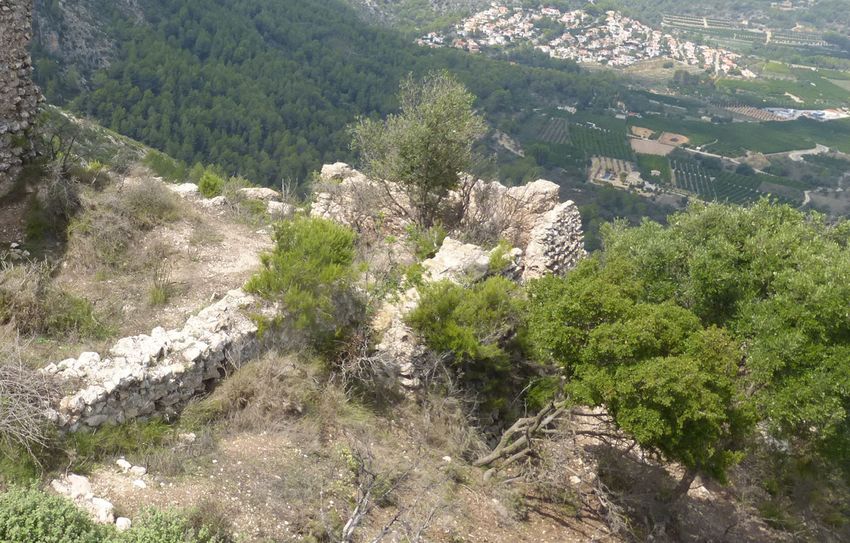
ENRIC ALFONS PAREDES VAÑÓ

1. CONTEXTUALIZATION                                       his son the podium of Orba, with the possibility
                                                           of building on it “forciam, turrem vel domum
“El Castellet” castle is located in the confluence
                                                           muratam vel alia fortitudinem”. López Elum also
of the municipalities of Orba and Murla (northeast
                                                           considers that Alfonso III made it clear that the
of the province of Alicante). This double ascription
                                                           jurisdiction of that alquería would continue to
provokes, a priori, a unique circumstance that
                                                           correspond to the castles of Alaguar or Pop.
adds to the already complex one on public-private
property. In any case, from the beginning of the           Similarly, the historian Josep Torró (Torró 2001:
journey it was accepted by the involved parties            461) mentions this information and alludes to the
that the really important thing was to save the            delimitation of the territory or jurisdictional term
castle and we had to start working on that line            of the castle that Berenguer Mercer was going to
as soon as possible. Thus, at the end of 2016              build it on a hill known as “Puig d’Orba”.
the first actions of study and documentation of
                                                           This clarifies the link between the castle of Orba
the monument were initiated by a team formed
                                                           and the “qarya” of Murla, which has led to this
of architect and archaeologist with the main
                                                           fortification also appearing as Murla castle, in the
objective of undertaking and defining the path of
                                                           historical documentation. On the other hand the
safeguarding the monument.
                                                           definition of the territory and the ascription of the
On the etymology it is worth mentioning that the           castle of Orba to the castles of Alaguar and Pop,
term Orba is derived from the Arabic form Awraba,          makes evident the supremacy of these. But, at the
as the historian Josep Torró undoubtedly defends           same time it shows the hierarchical articulation
(Torró 2007: 156). This same author, in reference          within the Vall de Laguar, a valley in which it is
to Pierre Guichard (Guichard 1976), also points            located and which it partially controls. Its position
out that it is a well-known Berber tribal name.            in the lower part of the valley allows it to guard
                                                           the two natural passages –mountain’s ports of
When reviewing the General Inventory file of
                                                           Parcent and Murla- (Figure 6) that connect the
the Valencian Cultural Heritage (no. code:
                                                           basins of the river Girona on the north and the
03.30.097-001) we perceived that only scarce
                                                           river Xaló on the south, the latter also called
data relating to the generic declaration is shown.
                                                           Gorgos (Figure 1).
This is because updating is still pending to date,
and that fact together with the small number of            The evidence contained in the historical
scientific publications that we can track about            documentation made the castle more interesting
the castle, places us in the position that this            to study and interpret as a whole, with the aim
fortification has occupied up to now among the             of showing it to society as it deserved. It was
scientific community. The low impact of the castle         inevitable to shed light on its values, without
contrasts with the importance that it must have            forgetting to take them hand in hand with the
had in medieval times, being a territorial reference       symbolic value that it represents today for the
extremely important. It is mentioned as early as           locals, because they feel identified by it and they
the twelfth century by al-Idrisi in his work entitled      hold it in high esteem (Figure 2).
“Uns al-Muhay” (Sezgin 1984).

The translation of the text in question makes it
clear its importance as a stopping point on the
road from Xàtiva to Dènia. It is said that: “From
Játiva to the castle (hisn) of Bayrén (Bayrdn)
there are eighteen miles, from Bayrén to the
castle of Awr.ba/Ur.ba/Urba” there are twelve
miles and from Awrba/your.ba/Urba to Denia
there are twelve miles”.

From the Christian period sources, thanks to
authors such as the historian Pedro Lopez Elum
(Elum 2002: 59), we know that Jaime I had given
Berenguer Mercer the alquería of Murla, and years
                                                           Fig. 1. Relief map with location of the castle (Institut
later (on January 17, 1289) Alfonso III granted
                                                           Cartogràfic Valencià).

                                                                                                                   |
                                  EGE - Revista de Expresión Gráfica en la Edificación, Nº 14, 2021. ISSN: 2605-082X 63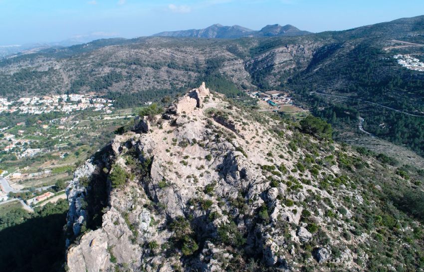
THE DRAWING AS A GUIDE BETWEEN THE STUDY AND THE INTERVENTION. THE CASTLE OF ORBA (ORBA-MURLA, ALICANTE. SPAIN)

Fig. 2. Historical view of the town of Orba, with the mountain behind it elevated by the ruins of the castle that
dominates the town. 1966 postcard. (Omnia Biblioteca Valenciana digital).

                                                            Because the fortification was in an advanced state
2. PREVIOUS STUDIES
                                                            of disrepair, partially filled with debris and covered
The castle began its safeguarding actions at the            with vegetation and even trees, in certain areas
end of 2016 aimed at its urban-heritage protection.         it was difficult or impossible to go near. This fact
With the complementation of the BIC declaration             hindered the work of architectural interpretation,
that submitted, in May 2017, to the Conselleria             so it was considered necessary to take the first
de Cultura. From the beginning the technical                action of clearing and selective removal of improper
team proposed to work following the guidelines              vegetation inside the enclosure. Subsequently, we
of the National Plan of Defensive Architecture              proceeded to carry out the Architectural Study
and with an integrative philosophy. In such a way           (included within the Previous Study) contemplating
that the actions undertaken were carried out                the following phases: morphotypological analysis,
with the aim of creating a route and the intention          constructive reading -covering techniques,
of broadening the scope, all in the absence of              materials and dimensional parameters- and study
systemic management figures such as a Master                of damages and deformations. The taking of formal
Plan. At the beginning of the Previous Studies              measures on the one hand and inspection and
there was a valuable document, a floor plan of              identification of the techniques, materials used
the castle made twenty-five years ago by Segura             and pathologies on the other hand, forms the base
and Torró (Figure 3) (Torró 2001: 461), thanks to           material from which, after appropriate analysis
it, it was possible to intuit a priori its relevance,       and interpretation, the architectural-constructive
magnitude and complexity of the monument to                 study can be written. The graphic support which
which we were going to save. However, the limits            reflects the reality of the remains is constituted
of the defensive set and the true size of some              of a graphic survey “ex novo” obtained from two
spaces were not clear.                                      sources, the aerial-terrestrial photogrammetry and
                                                            a thorough direct data collection using traditional

                                                                                                                    |
                                   EGE - Revista de Expresión Gráfica en la Edificación, Nº 14, 2021. ISSN: 2605-082X 64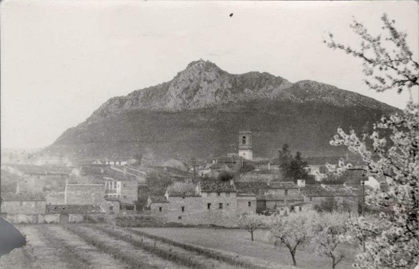
ENRIC ALFONS PAREDES VAÑÓ
Fig. 3. General and topographic floor plan. (Segura &Torró. July 1992).
means, aided by tape measure, freehand sketches specialization and experience that a professional
for subsequent digital tracing and photographic is able to detect and represent information, based
documentation (Figure 4). on pre-established codes and rules (Figures 5
and 6).
The digital drawing as a whole obtained from
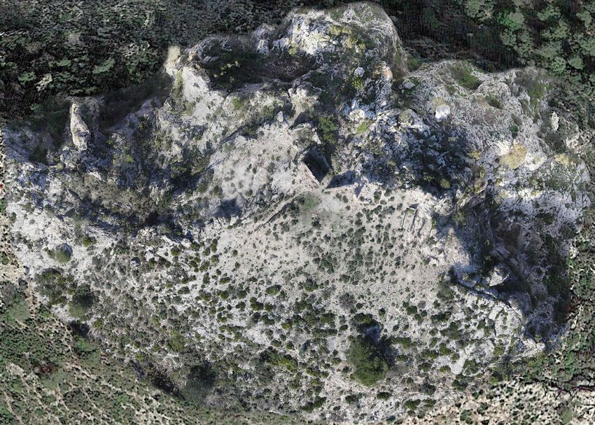
photogrammetry (Almagro 2019) was the crucial The drawings as the investigations progressed
instrument of the research, since it organised and were enriched and thus transmitted more
provided complete and integral information. Since information, while facilitating the synthesis of
it was difficult to interpret “in situ” because of the each topic analyzed. The graphic implementation
complexity of the initial state and the configuration is still alive and open to future work, understood
of the location itself, as it did not allow direct as a tool in transit that evolves and improves.
observation of certain perspectives. Data After several sessions of analysis “in situ” it was
collection using traditional methods and direct possible to identify and interpret the remains and
measurement (freehand drawing, flexometer, tape vestiges of the castle, and with this information
measure, plumb bob and spirit levels) were the it was possible to redraw much of the original
necessary complement to get detail information layout of the fortress. In this way it was possible
that is not seen in photogrammetry. It is only from to come up with the first hypothesis regarding the
|
EGE - Revista de Expresión Gráfica en la Edificación, Nº 14, 2021. ISSN: 2605-082X 65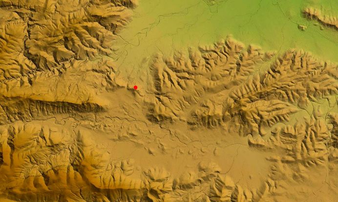
THE DRAWING AS A GUIDE BETWEEN THE STUDY AND THE INTERVENTION. THE CASTLE OF ORBA (ORBA-MURLA, ALICANTE. SPAIN)

Fig. 4. Lower tower perspective taken from upper tower. Previous Study Phase. (Own elaboration).

Fig. 5. Floor plan, elevations and section of the lower tower. 2017 (Own elaboration).

                                                                                                                    |
                                   EGE - Revista de Expresión Gráfica en la Edificación, Nº 14, 2021. ISSN: 2605-082X 66
ENRIC ALFONS PAREDES VAÑÓ
Fig. 6. North elevation of lower tower on orthophoto. Architectural studio. (Own elaboration).
articulation and functioning of the original spaces and prints such as burrs, joints, bars, needles,
and levels (see Figure 8), at least in part. The planks, etc. are observed (Figure 5), which allow
meticulous stratigraphic reading of the walls also for their characterization (Paredes 2016). Similar
allowed to investigate and propose hypotheses studies were carried out in a homologous way in
about the origin and subsequent evolution of the nearby Andalusian architectures (Soler 2015).
the fortification, based on geometry, metrology, In this phase, a complete study of the castle was
typology, techniques and overlays (Figure 6). carried out, understood as a material rest, but
finally also its location was analyzed -in a peri-
Regarding the construction techniques used in
urban area- as geophysical support and cultural
the castle, it is worth mentioning that the main
landscape (Soler 2018). Its territorial relationship
one is the wall (Márquez 2018) and three types
has been interpreted to propose a perimeter of
of different invoices are distinguished. It is also
protection according to the criteria established
noteworthy the existence of an inclined front wall
by the Valencian Cultural Heritage Law. That
on the outside of the east face of the lower tower
is, containing the perimeters of archaeological
(corner 2 of Figure 6; Figure 4) build with masonry
presumption, and including the adjoining
walls joined with lime mortar. This element acts
areas, demarcated according to geographical,
as a continuous reinforcement and allows access
topographical, ethnological and landscape
to the tower through a door opening. The state of
references, whose natural and rural components
the rammed earth is worrying and it requires an
make up the consubstantial landscape itself.
urgent consolidation, even so, through a careful
Likewise, the nearest routes and paths from
study valuable dimension and compositional
where it is possible to contemplate them have
data are obtained. On a smaller scale, traces
|
EGE - Revista de Expresión Gráfica en la Edificación, Nº 14, 2021. ISSN: 2605-082X 67THE DRAWING AS A GUIDE BETWEEN THE STUDY AND THE INTERVENTION. THE CASTLE OF ORBA (ORBA-MURLA, ALICANTE. SPAIN)
Fig. 7. Control position of the mountain’s port of Parcent and visual connection with the coast. Photography drone
flight 2017. Previous Study Phase (Segura Martínez, Ignacio).
been considered. This was possible from the 3. THE DRAWING AS A GUIDE
knowledge obtained from the architectural study
The tasks of the manual data collection and
in line with the studies from the historical and
digital graphic survey, constituted in themselves
archaeological fields. The interdisciplinary vision
and inseparably, an instrument of investigation
necessary to be able to define the protection
on the biography of the cultural asset. As the
environment and the delimitation of the perimeter
castle lacked graphic documents with sufficient
occupied by the Asset of Cultural Interest (known
definition to understand it in all its magnitude.
in Spanish as BIC).
Planimetries were elaborated in three stages of
We must continue to make progress in these work, throughout the period 2017-2019.
line of work and we need to continue with the
The first stage, delivered in May 2017, the
interdisciplinary study initiated in order to deepen
Complementation of the BIC, in which the
our knowledge as a whole. In addition, it is advisable
necessary representation of the visible remains
to conclude the archaeological intervention in the
on floor plan, elevations and sections in general
areas proposed in the 2018 project and that are
was elaborated.
still pending. They will surely provide valuable
information, both from the recovery of now hidden Then in October 2017 the lower tower was defined
structures, as well as from the interpretation of the in greater detail within the intervention project
chronologies or the sequencing of the constructive called “Emergency actions in lower tower”, the
stages. These data will enrich the architectural- work was completed in December 2017 (Paredes
constructive interpretation in order to propose 2017).
for more appropriate corrective measures to
The third stage, delivered in 2018, was the one
consolidate and restorate the monument, and its
corresponding to the project called “Intervention
ultimate goal, enhancement of the castle.
and enhancement of the “El Castellet” castle
|
EGE - Revista de Expresión Gráfica en la Edificación, Nº 14, 2021. ISSN: 2605-082X 68ENRIC ALFONS PAREDES VAÑÓ
Fig. 8. Interpretive general plan. 2018. (Own elaboration).
(Paredes 2018), which given the complexity in The drawings of the lower tower are the ones
the arrangement of the remains on the abrupt that have undergone the greatest change,
orography there was a questioning about the implementing their definition and information
views to be represented and the quality of the (Figures 5 and 11). Furthermore, the work in
graphic definition. The basic floor plant obtained this area has served to uncover temporal and
from the photogrammetry updates, reviews, evolutionary data of high interest that allow to
complements and improves the pre-existing floor understand its history as a whole (Figure 6).
plan, also incorporating the interpretation of how
All this documentation is completed with a
the spaces are articulated and the nomenclature
collection of aerial and terrestrial photographs
assigned for their identification (Figure 8).
(Figures 4, 7 and 9) that document the current
It was proposed to represent all the spaces as an inopportune state. Comparing photos after the
independent element and all the parts of the walls interventions allows to appreciate the evolution
remains were drawn in detail (Figure 6). However, to non-final states, but more acceptable from the
in order to significantly improve the assessment point of view of protection and enhancement. The
as a whole, it was necessary to reviwe the overall set of drawings for the Castle, is therefore the first
planimetry. Since fragmentation made it difficult to interpretive version that has been made and the
understand and interpret, it was finally considered first known drawing of the walls. The planimetry
appropriate to carry out the survey of the four together with the photographic documentation
cardinal views that facilitate a comprehensive constitutes a historical document that summarizes
view (Figure 10). The series of detailed drawings the very existence of the fortification, with its
of each space, printed on photogrammetry, superpositions or changes imposed over time
complements the formal information of the castle and its unique morphotypological. The exhaustive
(Figure 6). documentation generated has obviously been
|
EGE - Revista de Expresión Gráfica en la Edificación, Nº 14, 2021. ISSN: 2605-082X 69THE DRAWING AS A GUIDE BETWEEN THE STUDY AND THE INTERVENTION. THE CASTLE OF ORBA (ORBA-MURLA, ALICANTE. SPAIN)
Fig. 9. Aerophotogrammetry, orthophoto from drone. 2017. Previous Study Phase. (Segura Martínez, Ignacio).
Fig. 10. General Elevations. 2018 (Own elaboration).
|
EGE - Revista de Expresión Gráfica en la Edificación, Nº 14, 2021. ISSN: 2605-082X 70ENRIC ALFONS PAREDES VAÑÓ
Fig. 11. Drawings of the lower tower in previous state. 2017 (Own elaboration).
the graphic basis of the subsequent projects. barrel vault prints that covered it. In the upper
Along with composing an important source of part there is an enclosure with a greater degree of
information that remains as a legacy for future architectural complexity, raised with rammed earth
actions and scientific studies, it would be very and enclosing an area of approximately 717 m2.
pertinent to continue in order to save the castle. The upper enclosure presents a concatenation of
spaces with east-west directive which is joined to
a narrowed and rotated extension in the northwest
4. THE FORTIFICATION
front. There are very many deteriorated structures
After the architectural-constructive analysis it and some of them are considerably high. It can be
can be exposed that the defensive set is located seen from west to east: a large tower at the lowest
in a hill of 416 meters high, with an extension of level, a rectangular room, a smaller square tower
2,812 m2. The north face presents natural defense -at the highest level-, several canvases of walls
conditions with greater slope and cliff that hinder that possibly make up a smaller tower -pending
the passage. All other fronts have architecture research- and the upper cistern. The upper part
at the service of protection. A defensive set is characterized by a fairly comfortable slope that
composed of two distinct zones is interpreted. allows you to move about through the main body,
In the lower part are identified starts of walls of leaving the towers at different levels (Paredes
cyclopea masonry as a close. Possibly, configuring 2011). The lower tower presents four constructive
a temporary place to stay and therefore, a first phases with significant transformation with
defensive level with an extension of 2,096 m2. On respect to the original layout and it manifests itself
the south of the lower part, there is a cistern with as a primitive defensive structure that has evolved
|
EGE - Revista de Expresión Gráfica en la Edificación, Nº 14, 2021. ISSN: 2605-082X 71THE DRAWING AS A GUIDE BETWEEN THE STUDY AND THE INTERVENTION. THE CASTLE OF ORBA (ORBA-MURLA, ALICANTE. SPAIN)
Fig. 12. North elevation of the lower tower proposed intervention. Project 2018. (Own elaboration).
to what we see today. This tower needs a further inside is assumed to be the eastern front after the
in-depth study in order to determine its ascription last archaeological work (intervention of 2018).The
to the Muslim era and its possible link with the wall ceases to be identifiable on the south front,
nearby “qaryas” (villages) (Rodríguez 2018). but at ground level emerge remains of walls, which
Currently the remains have a secondary door on could belong to other dependencies of the castle.
the east front and they are highly representative of These would form a constructions line that would
the systems and construction techniques used as allow the defense of the upper enclosure on the
a whole. No remains of the tower access inside the southern front.
castle can be identified, although a hypothesis of
its location can be proposed. Attached in this tower
5. INTERVENTIONS
we find a pseudorectangular room, which presents
one of the highest preserved walls. Its short front From the beginning, an interdisciplinary team
could serve as an internal connector with the work specialized in the intervention of heritage
large tower. The passage to the room is likely to was suggested, which kept expanding according
have taken place at the corner that is formed by to the requirement from the different phases of
the southwest vertex. Because of the constructive work. A team consisted of: architect, building
evidences found in the base at the end of the wall engineer, archaeologist and historian was
that comes from the upper tower. The upper tower completed. This team always advocated working
located in the center of the north front of the main with rigor, premises and sufficient content in order
body rises three meters above the access level. to have information as complete and transversal
It is a small dimension tower, being on the part as possible on the whole. Therefore, although
that is higher, it would be the most representative, there was no Master Plan of the “El Castellet”
functioning as a watchtower -in the absence of castle, it was in a position to propose, under a
specifying the original height-. Its access from the comprehensive conception, actions of minimum
|
EGE - Revista de Expresión Gráfica en la Edificación, Nº 14, 2021. ISSN: 2605-082X 72ENRIC ALFONS PAREDES VAÑÓ
impact and maximum needs. The interventional Once the interior space was emptied it was
philosophy is based on the preservation of documented. Operations of sanitizing and
the remains and the rescue of the heritage cleaning, internal consolidation, sealing of
interests of the monument. Having as premises fissures and cracks, punctual replacement of
the principles of reversibility; respect for the improper volumes and hollows, application of
materiality and essential values of the property; sacrifice mortars in coronations seriously affected
and compatibility of the material and formal and finally chromatic integration, consolidation
scope. Of course, always facilitating the subtle and hydrofugation was carried out on the
differentiation between the original-new. Thus, walls. All these was done using techniques and
even though the first impression seemed to show materials compatible with the originals but with
the desirability of intervening in certain unstable a clear visual distinction in terms of color and
elements, it was nevertheless not feasible due to texture, in addition to the setback of the existing
budgetary reasons required to undertake such surfaces in the new performances. With all these,
work at that time. On the other hand, a precarious a substantial improvement on the remains of the
situation of the lower tower was detected. At tower was achieved, considerable progress was
several points, on the verge of disappearance in made in the architectural and constructive study
the architectural analysis phase. The material of the complex and a minimum itinerary was
and formal complexity it concealed was also provided that allows the approach to a “novel”
discovered. Finally, it was understood that is was space for visitors. The intervention has made
of exceptional interest for the temporalization the visit to the Castle begin to add nuances.
and evolution of the fortification. Once the The contemplation of the ruins as evocative of a
serious damages affecting it were determined, memory, a past and a history. With this begins the
and the high risk it suffered from irreversible loss diffusion, with some guided tours at the beginning
was considered, it was in a position to consider by technical specialists that explain the content
that the lower tower should be the first element managements of the patrimonial values. In the
to be safeguarded. The pathology that afflicted first intervention (October-November 2017),
the remains of the lower tower was multiple and with the financial help from the Conselleria de
varied. Mainly the clogging containing improper Cultura since the official announcement on May
fillings in the interior volume (more than 1.5 12, 2017, the appropriate operations of cleaning,
meters high) and the absence of continuity and consolidation and protection of the walls were
connection between the four elevations was made carried out and a minimum provisional itinerary
up of an amount of damages that required urgent was generated that allowed the approach to
action was presented. The gaps in the entire a “novel” space. The visit to the castle begins
vertical and thickness of the east and north walls to add nuances and considerably enriches
together with the collapse of the west elevation the contemplation as a whole. The second
endangered the north front (elevation 02-01 of intervention (October-December 2018), also had
the drawings) that was disconnected at both the financial support from the Conselleria de
ends and subjected to thrusts that caused cracks Cultura since the official announcement on April
and fissures on the vertical component. The 18, 2018. The project was drafted with an integral
lack of coronation and covering also aggravated scope of the monument, proposing a consolidation
the situation. The intervention consisted on the and generalized enhancement. However, due to
removal of the filling material from the interior budgetary reasons only a small part of it could
using archaeological methods, which eliminated be executed, which was considered as the first
the horizontal thrusts of the elevations and also phase and it materialized in the architectural field
allowed to distinguish the different wall typologies as a continuation of the first intervention. Mainly
that is comprised of and with this it was possible it acted on the remains of the lower tower and
to study in depth the sequencing on the formation allowed it to develop part of the pre-established
and evolution of the castle. A micro-intervention archaeological phase. This served as a starting
action focused on the affected points on the walls point for further action. Additionally, the clearing
was proposed to reduce further deterioration, and removal of selective vegetation within the
providing greater stability to the critical points perimeter of the upper enclosure was carried out.
and improving water runoff. Access paths were also recovered and information
|
EGE - Revista de Expresión Gráfica en la Edificación, Nº 14, 2021. ISSN: 2605-082X 73THE DRAWING AS A GUIDE BETWEEN THE STUDY AND THE INTERVENTION. THE CASTLE OF ORBA (ORBA-MURLA, ALICANTE. SPAIN)
and observation points were created. In addition, “El Castellet” castle must be considered as still
it was estimated that the timely implementation in process. It should be noted that there are
of information panels in strategic points of the many pending actions for the protection of the
enclosure, could improve visitors comprehension castle, and some are necessary and urgent and
and interpretation. should not be delayed further in order to avoid
the collapse and irreversible loss of elements
seriously affected and in danger of instability.
6. CONCLUSIONS
On the other hand, it is deemed opportune to
Without the exhaustive and thoughtful process urgently recover elements that have recently lost
of analysis and study of the castle, channelled part of their volumetry and to rescue others that
and materialized in large part by the graphic are almost imperceptible as they are covered
representation, decision-making would have been by debris. In addition, it would be necessary to
different. Surely, rather skimpy and less potent are covered complete the valorization of the
and this would have led to low quality results, monument in order to allow visitants to like
precision and adequacy to the cultural asset object and contemplate it in an integral way. However,
of intervention. Therefore, the drawing process the evaluation of the process formulated, the
must be understood as a representative channel scientific experience and the results obtained
of ideas, that is, as a compositional medium and is very positive. At the same time, it should
as an aesthetic object. But at the same degree serve as an example for other cultural assets
it should be considered as a content channel, so with similar characteristics and in precarious
it is a transmitter and enhancer of knowledge. conditions of guardianship and budget to be
But besides, after being able to coordinate the encouraged to undertake a historic safeguarding
parallel growth of ideas – formal and projective challenge. It remains to be said that the rigor and
– it is also possible to defend the latent function determination that has been characterized in the
of drawing as a backbone and living entity. Since works of protecting of the “El Castellet” castle,
a drawing is transformed and implemented with underlies the graphic expression, elaborated in a
new information during the course of a scientific living and continuous process, and that in short
investigation, as if in transit between the previous it has been the indisputable protagonist of the
study and the intervention in the architectural conceptual work carried out.
heritage. An intervention as in the case of the
REFERENCES
Al-Idrísí, Uns al-muhaŷ wa-rawd al-furaŷ, reproducción facsímil de dos manuscritos preparada por Fuat
Sezgin. Stuttgart 1984, s. p., ms. 1 fol. 158 y ms. fol. 115; edición parcial, estudio y traducción de Jassim
Abid Mizal, Los caminos de al-Andalus en el siglo XII, según “Uns al-muhaŷ wa-rawd al-furaŷ (Solaz de
los corazones y prados de contemplación, Madrid 1989, texto. ár. p. 66, trad. p. 94 Y Pp. 302-303.
Almagro Gorbea, A. 2019. “Medio siglo documentando el patrimonio arquitectónico con
fotogrametría”. EGE Revista de Expresión Gráfica en la Edificación, [S.l.], No. 11, p. 4-30, dic.
https://doi.org/10.4995/ege.2019.12863
Guichard, P. (1976). Al-Andalus. Estructura antropológica de una sociedad islámica en Occidente. Barral
Editores, Barcelona. ISBN: 84-211-2016-6.
Ley 4/1998, de 11 de junio, del Patrimonio Cultural Valenciano. Publicado en DOCV núm. 3267 de 18 de
Junio de 1998 y BOE núm. 174 de 22 de Julio de 1998.
López Elum, P. 2002. Los castillos valencianos en la Edad Media (materiales y técnicas constructivas).
Siglos XIII-XIV. Valencia. Consejería de Cultura / Biblioteca Valenciana. https://bivaldi.gva.es/en/
catalogo_imagenes/imagen.do?posicion=1&path=1001841®istrardownload=1
|
EGE - Revista de Expresión Gráfica en la Edificación, Nº 14, 2021. ISSN: 2605-082X 74ENRIC ALFONS PAREDES VAÑÓ
Márquez Bueno, S. 2018. “La tecnología constructiva andalusí: obra encofrada y revestimientos en la
arquitectura militar (ss. XI-XIII). El ejemplo de las torres”. Arqueología de la Arquitectura, No. 15, e076.
https://doi.org/10.3989/arq.arqt.2018.007
Omnia. Biblioteca Valenciana digital. https://bivaldi.gva.es/es/consulta/registro.do?id=10320
Paredes Vañó, E.A. 2011. “Aproximación a la arquitectura de las fortificaciones en las montañas del
valle central del Serpis. Las Torres (Alicante)”. Actas del Séptimo Congreso Nacional de Historia de la
Construcción, Santiago de Compostela, 26-29 octubre de 2011. Páginas: 1043-1054. Editor: Instituto
Juan de Herrera. https://dialnet.unirioja.es/servlet/articulo?codigo=4137841
Paredes Vañó, E.A., Soler Estrela, A. 2016. “Caracterización de materiales para la conservación de
tapias en las fortificaciones hispano-musulmanas”. Actas de las segundas jornadas sobre historia,
arquitectura y construcción fortificada: Madrid, 6-7 de octubre de 2016. Páginas 583-597. Actas de las
segundas jornadas sobre historia, arquitectura y construcción fortificada: ISBN 9788494600012.
Paredes Vañó, E.A. Arquitecto (2017). “Proyecto de actuaciones de emergencia en la Torre Inferior. El
Castellet (Murla-Orba, Alicante). Promotor: Ajuntament d’Orba.
Paredes Vañó, E.A. Arquitecto (2018). “Proyecto de intervención y puesta en valor de “El Castellet”.
Orba-Murla (Alicante). Promotor: Ajuntament d’Orba.
Plan Nacional de Arquitectura Defensiva (2012). Ministerio de Educación, Cultura y Deporte.
http://www.mecd.gob.es/planes-nacionales/planes/arquitectura-defensiva.html
Rodríguez-Navarro, P. 2018. Las Torres Árabes de las Alquerías Valencianas, ed. Tirant, Valencia.
ISBN: 9788417203689
Segura Martí, J.Mª., Torró Abad, J. 1992. Plano de planta del Castellet del Puig d’Orba (Murla). No
publicado.
Soler Estrela, A., Paredes Vañó, E.A., Verdú Soler, R. 2015. Architecture and landscape in Sharq al-
Andalus. The conservation of an Islamic qarya. Earthen Architecture: Past, Present and Future – Mileto,
Vegas, García Soriano & Cristini (Eds).
Soler Estrela, A. 2018. “Cultural Landscape Assessment: The Rural Architectural Heritage (13th–
17th Centuries) in Mediterranean Valleys of Marina Alta, Spain”. Buildings 2018, No. 8, 140
https://doi.org/10.3390/buildings8100140
Torró i Abad, J. 2001.“Dominar las aljamas. Fortificaciones feudales en las montañas del reino de Valencia
(siglos XIII-XIV)”. Mil anos de fortificações na Península Ibérica e no Magreb (500-1500). Ed. Isabel-C.
Ferreira Fernandes. https://www.academia.edu/3079275/Dominar_las_aljamas_Fortificaciones_
feudales_en_las_monta%C3%B1as_del_reino_de_Valencia_siglos_XIII_XIV_
Torró i Abad, J. 2007. “Vall de Laguar. Asentamientos, terrazas de cultivo e irrigación en las
montañas de Sarq al – Andalus: un estudio local”. Recerques del Museu d’Alcoi, 16. (151-182).
https://www.raco.cat/index.php/RecerquesMuseuAlcoi/article/view/172370/0
How to cite this article: Paredes Vañó, E.A. 2021. “The drawing as a guide between the study
and the intervention. The castle of Orba (Orba-Murla, Alicante. Spain)”, EGE Revista de Expresión
Gráfica en la Edificación, No. 14, Valencia: Universitat Politècnica de València. pp. 62-80.
https://doi.org/10.4995/ege.2021.15728
|
EGE - Revista de Expresión Gráfica en la Edificación, Nº 14, 2021. ISSN: 2605-082X 75EL DIBUJO COMO GUIA ENTRE EL ESTUDIO PREVIO Y LA INTERVENCION. EL “CASTELLET” DE ORBA
(ORBA-MURLA, ALICANTE. ESPAÑA)
1. CONTEXTUALIZACION De igual modo el historiador Josep Torró (Torró 2001:
461) hace mención a esta información y alude a la
El Castellet se encuentra situado en la confluencia de delimitación del territorio o término jurisdiccional del
los términos municipales de Orba y Murla (al noreste castillo que iba a construir Berenguer Mercer en el Puig
de la provincia de Alicante). Esta doble adscripción d’Orba.
plantea, a priori, una singular circunstancia que se suma
Con ello se esclarece el vínculo entre el castillo de
a la ya de por sí compleja sobre la propiedad pública-
Orba y la alquería de Murla, lo que ha propiciado que
privada. En cualquier caso, desde el comienzo de la
esta fortificación aparezca también denominada como
andadura se sobreentendía por todas las partes que
castillo de Murla, en la documentación histórica. De
lo realmente importante era salvar el castillo y había
otra parte la definición del territorio y la adscripción del
que empezar a trabajar en esa línea cuanto antes. Así
castillo de Orba a los castillos de Alaguar y Pop, hace
pues, a finales de 2016 se inician las primeras acciones
patente la supremacía de estos. Pero, a la vez muestra
de estudio y documentación del monumento por parte
la articulación jerárquica dentro del Vall de Laguar, valle
de un equipo formado por arquitecto y arqueólogo con
en el que se enclava y al que controla parcialmente.
el objetivo principal de emprender y guiar el camino de
Su posición en la parte baja del valle permite vigilar
salvaguarda del monumento.
los dos pasos naturales -puertos de Parcent y de
Sobre la etimología cabe mencionar que el termino Murla- (Figura 6) que comunican las cuencas de los
Orba deriva de la forma árabe Awraba, como defiende ríos Girona al norte y Xaló al sur, este último también
sin duda alguna el historiador Josep Torró (Torró 2007: llamado Gorgos (Figura 1).
156). Este mismo autor, en referencia a Pierre Guichard
Estas evidencias en la documentación histórica
(Guichard 1976), destaca además que es un gentilicio
hacía más interesante el estudio e interpretación del
tribal beréber muy conocido.
conjunto, con el objetivo de mostrarlo a la sociedad
Al revisar la ficha del Inventario General del Patrimonio como se merecía. Era ineludible aportar luz sobre sus
Cultural Valenciano (núm. de código: 03.30.097-001) valores, eso sí, sin olvidar llevarlos de la mano del valor
percibimos que únicamente se muestran escuetos simbólico que representa en la actualidad para los
datos referentes a la declaración genérica. Esto es lugareños, por el aprecio e identificación que sienten
así porque sigue pendiente de actualizar aun a día hacia “el Castellet” (Figura 2).
de hoy, y ese hecho junto con el reducido número
de publicaciones científicas que podemos rastrear
sobre el castillo, nos sitúa acerca de la posición que 2. LOS ESTUDIOS PREVIOS
ha ocupado esta fortificación hasta la fecha para la
El castillo inició a finales de 2016 su salvaguarda con
comunidad científica. La baja repercusión del castillo
acciones encaminadas a su protección urbanístico-
contrasta con la importancia que este debió tener
patrimonial. Con la complementación de la declaración
en época medieval, siendo un referente territorial de
BIC que fue presentada, en mayo de 2017, ante la
primer orden. Aparece mencionado ya en el siglo XII
Conselleria de Cultura.
por al-Idrisi en su obra titulada “Uns al-Muhay”(Sezgin
1984). Desde el principio el equipo técnico propuso trabajar
siguiendo las directrices del Plan Nacional de
La traducción del texto en cuestión deja patente su
Arquitectura defensiva y con una filosofía integradora.
importancia como punto de parada en el camino de
De tal manera que las acciones emprendidas se
Xàtiva a Dènia. Se dice que: “De Játiva al castillo (hisn)
realizaban con objetivo de que tuvieran recorrido y
de Bayrén (Bayrdn) hay dieciocho millas, de Bayrén al
vocación de mayor amplitud y alcance, todo ello en
castillo de Awr.ba/Ur.ba/Urba” hay doce millas y de
ausencia de figuras de gestión sistémica como sería
Awrba/Ur.ba/Urba a Denia hay doce millas”.
un Plan Director.
Por las fuentes de época cristiana, gracias a autores
Al inicio de los Estudios Previos se disponía de un
como el historiador Pedro Lopez Elum (Elum 2002: 59),
valioso documento, el plano de planta del castillo
sabemos que Jaime I había dado a Berenguer Mercer
realizada veinticinco años antes por Segura y Torró
la alquería de Murla, y años después (el 17 de enero
(Figura 3) (Torró 2001: 461), gracias al cual se podía
de 1289) Alfonso III le concedía a su hijo el podium de
intuir a priori su relevancia, magnitud y complejidad
Orba, con la posibilidad de constriur en él “forciam,
del monumento al que íbamos a tratar. No obstante no
turrem vel domum muratam vel alia fortitudinem”.
quedaban claros los límites del conjunto defensivo ni la
López Elum considera asimismo, que Alfonso III dejaba
verdadera dimensión de algunos espacios.
claro que la jurisdicción de aquella alquería seguiría
correspondiendo a los castillos de Alaguar o Pop.
|
EGE - Revista de Expresión Gráfica en la Edificación, Nº 14, 2021. ISSN: 2605-082X 76ENRIC ALFONS PAREDES VAÑÓ
Debido a que la fortificación se encontraba en también investigar y plantear hipótesis sobre el origen
avanzado estado de deterioro, parcialmente colmatada y evolución posterior de la fortificación, basándose
de tierras y cubierta de vegetación e incluso arbolado, en la geometría, metrología, tipología, técnicas y
en determinadas zonas era difícil o imposible su superposiciones (Figura 6).
acercamiento. Este hecho dificultaba el trabajo de
Al respecto de las técnicas constructivas empleadas
interpretación arquitectónica, por lo que se estimó
en el castillo cabe mencionar que la principal es la
necesario una primera actuación de desbroce y
tapia (Márquez 2018) y se distinguen tres tipos de
retirada selectiva de vegetación impropia en el interior
diferente factura. También es destacable la existencia
del recinto.
de un frente ataludado por el exterior de la cara este
Posteriormente, se procedió a realizar el Estudio de la torre inferior (esquina 2 de la Figura 6; Figura 4)
Arquitectónico (incluido dentro del Estudio Previo) resuelto con sillarejo tomado con mortero de cal. Este
contemplando las siguientes fases: análisis elemento cual actúa como refuerzo continuo y permite
morfotipológico, lectura constructiva -abarcando el acceso a la torre a través de un vano. El estado del
técnicas, materiales y parámetros dimensionales- y tapial es preocupante y exige su consolidación urgente,
estudio de lesiones y deformaciones. aun así, con un detenido estudio se obtienen valiosos
datos dimensiones y compositivos. A menor escala
La toma de medidas formales por una parte y de
se observan trazas y huellas como rebabas, juntas,
inspección e identificación de las técnicas, materiales
barzones, agujales, tablones, etc. (Figura 5), que
empleados y patologías por otra, conforma el material
permiten su caracterización (Paredes 2016). Estudios
base a partir del cual, tras el oportuno análisis e
similares se han realizado de manera homóloga en
interpretación poder redactar el estudio arquitectónico-
arquitecturas andalusíes próximas (Soler 2015).
constructivo.
En esta fase, se realizó un completo estudio del castillo
El soporte gráfico sobre el cual reflejar la realidad de los
entendido como resto material, pero finalmente también
restos se constituye con un levantamiento gráfico “ex
de se analizó su enclave -en ámbito periurbano-
novo” obtenido a partir de dos fuentes, la fotogrametría
como soporte geofísico y paisaje cultural (Soler
aérea-terrestre y una minuciosa toma de datos directa
2018). Se ha interpretado su relación territorial para
con medios tradicionales, ayudados por cinta métrica,
proponer un perímetro de protección atendiendo a los
croquis a mano alzada para su posterior trazado digital
criterios que establece la Ley del Patrimonio Cultural
y documentación fotografía (figura 4).
Valenciano. Esto es, conteniendo los perímetros de
El dibujo digital de conjunto obtenido desde la presunción arqueológica, e incluyendo los ámbitos
fotogrametría (Almagro 2019) era el instrumento colindantes, deslindados según referentes geográficos,
crucial de la investigación, ya que ordenaba y aportaba topográficos, etnológicos y paisajísticos, cuyas
información completa e integral. Puesto que era componentes naturales y rurales conforman el paisaje
difícil de interpretar “in situ” por la complejidad del consustancial propio. Asimismo, se han considerado
estado inicial y la propia configuración del enclave, los caminos y sendas más próximas desde donde es
que no permitía la observación directa de ciertas posible su contemplación. Esto fue posible desde los
perspectivas. La toma de datos mediante métodos conocimientos obtenidos en el estudio arquitectónico
tradicionales y medición directa (dibujo a mano alzada, en consonancia con los estudios desde los ámbitos
flexómetro, cinta métrica, plomada y niveles) era el histórico y arqueológico. Visión interdisciplinar
complemento necesario para la información de detalle necesaria para poder definir el entorno de protección
que no se aprecia en la fotogrametría. Sólo desde la y la delimitación del perímetro que ocupa el Bien de
especialización y la experiencia el profesional es capaz Interés Cultural.
de detectar y representar, en base a códigos y reglas
Se debe seguir avanzando en estas líneas de trabajo y
preestablecidas (Figuras 5 y 6).
se precisa continuar el estudio interdisciplinar iniciado
Los dibujos a medida que avanzaban las investigaciones para profundizar en el conocimiento del conjunto.
se enriquecían y con ello transmitían mayor información, Además, es conveniente concluir la intervención
a la vez que facilitaban la síntesis de cada temática arqueológica en las áreas propuestas en el proyecto del
analizada. La implementación gráfica sigue viva y 2018 y que siguen pendientes. A buen seguro aportaran
abierta a futuros trabajos, entendida esta como una valiosa información, tanto desde la recuperación de
herramienta en tránsito que evoluciona y mejora. estructuras ahora ocultas, como desde la interpretación
de las cronologías o la secuenciación de las etapas
Tras varias sesiones de análisis “in situ” se pudo constructivas. Datos estos que enriquecerán la
identificar e interpretar los restos e improntas, y con ello interpretación arquitectónico-constructiva de cara
redibujar gran parte del trazado original de la fortaleza. a plantear medidas correctoras más adecuadas de
De esta manera se logró plantear una primera hipótesis consolidación y restauración en el monumento, y su fin
al respecto de la articulación y funcionamiento de los último, la puesta en valor del castillo.
espacios y niveles originales (ver Figura 8), al menos
en parte. La meticulosa lectura muraria permitió
|
EGE - Revista de Expresión Gráfica en la Edificación, Nº 14, 2021. ISSN: 2605-082X 77EL DIBUJO COMO GUIA ENTRE EL ESTUDIO PREVIO Y LA INTERVENCION. EL “CASTELLET” DE ORBA
(ORBA-MURLA, ALICANTE. ESPAÑA)
El conjunto de planos del Castellet, es por tanto la
3. EL DIBUJO COMO GUIA
primera versión interpretativa que se ha hecho y el
Las tareas de toma de datos manual y levantamiento primer levantamiento murario conocido. La planimetría
gráfico digital, constituyeron en sí mismas y de junto con la documentación fotográfica constituye un
manera inseparable, un instrumento de investigación documento histórico que resume la existencia propia
sobre la biografía del bien. Como el castillo carecía de la fortificación, con sus superposiciones o cambios
de documentos gráficos con definición suficiente impuestos a lo largo del tiempo y sus singularidades
que permitiera entenderlo en toda su magnitud, se morfotipológicas.
elaboraron planimetrías en tres etapas de trabajo, a lo La exhaustiva documentación generada ha sido
largo del periodo 2017-2019. evidentemente la base gráfica de los proyectos
La primera etapa, entregada en mayo de 2017, fue posteriores. Además de componer una importante
la Complementación del BIC, en la que se elaboró la fuente de información que queda como legado para
necesaria representación de los restos visibles en futuras actuaciones y estudios científicos, que sería
planta, alzados y secciones en general. muy pertinente continuar en aras a salvar el castillo.
Seguidamente en Octubre de 2017 se definió con
mayor detalle la torre inferior dentro del proyecto de 4. LA FORTIFICACION
intervención denominado “Actuaciones de emergencia
en torre inferior”, con obras finalizadas en diciembre de Tras el análisis arquitectónico-constructivo se puede
2017 (Paredes 2017). exponer que el conjunto defensivo se ubica sobre un
cerro de 416 metros de altitud, con una extensión de
La tercera etapa, entregada en 2018, fue la
2.812 m2. La cara norte presenta unas condiciones
correspondiente al proyecto llamado “Intervención y
de defensa naturales con mayor pendiente y cortes
puesta en valor del Castellet” (Paredes 2018), el cual
que dificultan el paso. El resto de frentes tienen a la
dada la complejidad en la disposición de los restos
arquitectura al servicio de la protección.
sobre la abrupta orografía supuso un cuestionamiento
a cerca de las vistas a representar y la calidad de la Se interpreta un conjunto defensivo compuesto por
definición gráfica. dos zonas diferenciadas. En la parte baja se identifican
arranques de muros de mampostería ciclópea a modo
La planta básica obtenida a partir de la fotogrametría
de cerca. Posiblemente, configurando un espacio de
actualiza, revisa, complementa y mejora la planta
estancia temporal y por tanto, un primer nivel defensivo
preexistente, incorporando además la interpretación
con una extensión de 2.096 m2. Al sur de parte baja,
de cómo se articulan los espacios y la nomenclatura
se identifica un aljibe con improntas de la bóveda de
asignada para su identificación (Figura 8).
cañón que lo cubría.
Se planteó representar cada estancia como un
En la parte alta se localiza un recinto con mayor grado
elemento independiente y en cada espacio se dibujaron
de complejidad arquitectónica, levantado con tapias y
los restos murarios en detalle (Figura 6). No obstante,
cerrando una superficie de aproximadamente 717 m2.
para mejorar notablemente la apreciación del conjunto
era necesario revisar la planimetría general. Puesto El recinto superior presenta una concatenación de
que la fragmentación dificultaba el entendimiento espacios con directriz este-oeste a la que se añade una
e interpretación, finalmente, se consideró oportuno extensión estrechada y girada en el frente noroeste.
realizar el levantamiento de las cuatro vistas cardinales Se encuentran estructuras muy deterioradas pero
que facilitan una visión integral (Figura 10). La serie algunas con alturas considerables. Se puede apreciar
de dibujos de detalle de cada espacio, grafiada sobre de oeste a este: una gran torre en la cota más baja,
la fotogrametría, viene a complementar la información una sala rectangular, una torre cuadrada más pequeña
formal del castillo (Figura 6). -en la cota más elevada-, varios lienzos de muros que
conforman posiblemente una torre menor -pendiente
Los planos de la torre inferior son los que mayor cambio
de investigación- y el aljibe superior. La parte alta se
han experimentado, implementando su definición e
caracteriza por una pendiente bastante cómoda que
información (Figuras 5 y 11). Además, los trabajos en
permite transitar por el cuerpo principal, quedando las
esta zona han servido para desvelar datos temporales
torres a diferente cota (Paredes 2011).
y evolutivos de alto interés que permiten comprender la
historia del conjunto (Figura 6). La torre inferior presenta cuatro fases constructivas
con significativa transformación respecto del trazado
Toda esta documentación se completa con una
original y manifiesta ser una primitiva estructura
colección de fotografías aéreas y terrestres (Figuras 4,
defensiva que evolucionará a lo que hoy vemos. Esta
7 y 9) que documentan el inoportuno estado actual. La
torre precisa de un estudio en mayor profundidad
comparativa con fotos posteriores a las intervenciones
que determine su adscripción a época musulmana
permiten apreciar la evolución a estados no finales,
y su posible vinculación con las alquerías cercanas
pero más aceptables de recuperación y puesta en valor.
|
EGE - Revista de Expresión Gráfica en la Edificación, Nº 14, 2021. ISSN: 2605-082X 78You can also read