The Blessington Study, 2019 - Town Centre Health Check, Town Centre Strategy and Suggested Improvements/Objectives for the Future - Wicklow County ...
←
→
Page content transcription
If your browser does not render page correctly, please read the page content below
The Blessington Study, 2019
           Town Centre Health Check,
           Town Centre Strategy and
Suggested Improvements/Objectives for the Future

                                                   1
2
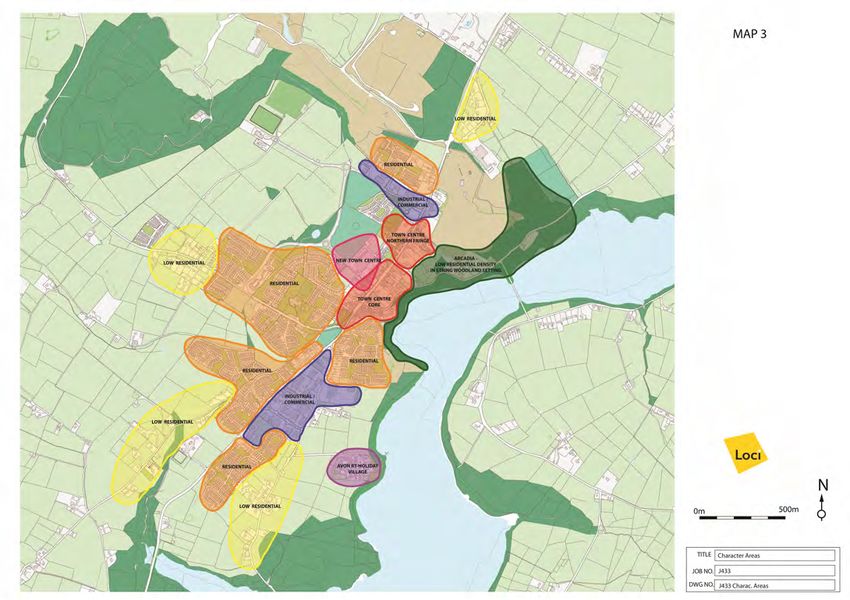
Table of Contents

                                                             Page

1.   Introduction                                              4

2.   Environmental and Landscape Character                     6

3.   Land Use Survey and Assessment                           16

4.   Building Condition and Redevelopment Opportunities       20

5.   Public Realm Analysis and Townscape Management           22

6.   Town Centre Strategy                                     35

7.   Urban Design Proposals and Environmental Improvements    42

                                                                    3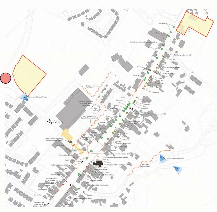
Chapter 1—Introduction
This study started out a ‘Health Check,’ prepared voluntarily on behalf of
the Blessington Forum & Tidy Towns Committee working with the Bless-
ington Town Team, a group composed of officials from Wicklow County
Council and local community representatives.

A Health Check is a descriptive tool for determining some of the issues
with the town and can be used to compare its ‘health’ or vibrancy rela-
tive to other areas. In essence, it is a descriptive tool – describing what it
sees and current conditions.

This study relied on some initial survey work, examining firstly the local
landscape character and environmental features. As the overall land-
scape character is the setting for the town, its relationship with its sur-
roundings is important; it can absorb development and it provides the
natural amenities that the town depends on. Other baseline surveys
included a land use survey, a building condition survey and an urban de-
sign analysis which included looking at the heritage features of the town.

The study also provides some suggestions for improvements, some of
these are small actions that can be driven by the Tidy Towns Committee
with the support of the local community and businesses, whereas other
proposals are bolder and may require further consultation with the pub-
lic and landowners and they will necessitate a higher level of buy-in and
commitment and of course funding from private businesses, the Council
and central government funds and initiatives. The founders of Blessing-
ton, the Hills and the Downs, had great plans for Blessington—and the
town still retains its inherent character and structure. This study includes
some small and minor improvements and actions that can be acted on
immediately, in addition to broader aspirations that may take a much
greater commitment (in terms of investment and time) and a longer
timeframe for delivery.

The surveys and studies provide the basis for the Health Check, but the
Blessington Study includes not just analysis, but a list of actions/
recommendations and some suggested development objectives and/or
design interventions.

Eoghan Ryan, B.A., M.R.U.P, M.Sc. (Urban Design)

                                                                                 4
All Maps were digitally prepared by Loci Urban Design Consultants,
41 Dominick Street Lower, Dublin 1.

www.loci.ie

info@loci.ie

                                                                     5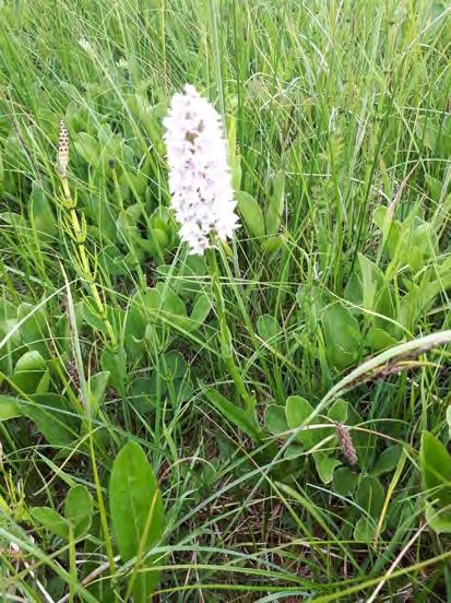
Chapter 2—Environmental & Landscape Character

Objective:

To protect the natural and intrinsic character of Blessington that gives
it its special identify, while allowing for its sustainable growth and de-
velopment

Blessington is an attractive town on the Wicklow Kildare border with a
rich environmental quality. The most significant features of the land-
scape in and around Blessington are:

1. The undulating landscape and in particular the esker hills to the
north and west of the town, notably Glending Wood.

2. The Poulaphouca Reservoir with its heavily wooded banks.
3. A stream system and its associated ponds and wetlands, that runs
from the north of the GAA grounds (and the Quarry Pits) and runs south
to Glebe East and Burgage More feeding into the Reservoir.

The significant mature tree stands that define some of the field bounda-
ries and other clusters and groupings as outlined on the ‘Environmental
Features Map’ including those tree groups within the town.

The town is elevated at some 223 metres high above sea level. The
landscape is rolling and undulating – reflecting the significant glacial
features (eskers and moraines) deposited after the last Ice Age. The
town nestles neatly between the hills of Knockieran/Butterhill to the
west and the Glending/Deerpark Hills to the east. These latter hills are
part of a longer esker ridge that runs parallel to the N81 and continue
back to Brittas and Saggart Hill. Indeed, they continue south of Blessing-
ton for some distance too. The sand and gravel ridges are ideal for quar-
rying and the town’s proximity to Dublin City makes them attractive and
profitable for extraction. The N81 north of the town and the local road
system is impacted in terms of the dirt and silt on its surface and its mar-
gins, with ‘greying’ of grass verges and hedgerows. The depth of the
some pits goes well beyond the water table mark but modern regula-
tions and planning controls demand that stricter environmental stan-
dards have to be met, including regular monitoring and testing and set-
tlement/detention ponds to collect silt and prevent it from entering sur-
face streams in the vicinity. Despite their significant impact on the land-
scape, ironically, there is some unexpected fruitfulness to be found in
these areas – wildflowers grow on sandy nutrient stripped soil; rabbits,
hares and foxes are resident; sand martins nest in its sandy banks; ra-
vens and peregrines nest on the newly formed cliffs; while buzzards and
kestrels hunt and nest in the vicinity (the National Parks and Wildlife
Service have erected nest boxes for kestrels, barn owls and peregrines in
disused quarry areas and some of these species are nesting on man-
                                                                               Top Photo: Views of Blessington Lakes from the Kilbride
made cliff faces at quarry sites).                                             Road; Second from top: Blessington Town with Wicklow
                                                                               Mountains backdrop; second photo from bottom: A sig-
One of the most significant features in the town is the Blessington Lake
                                                                               nificant group of trees within Deerpark; bottom photo:
lying immediately west of the town and extending for some 20 square            view southwest showing esker ridge and mature beech
kilometres. Although manmade, the Poulaphuca Reservoir is fed by the           trees.

                                                                                                                                         6
Map 1—Environmental and Landscape Features

                                             7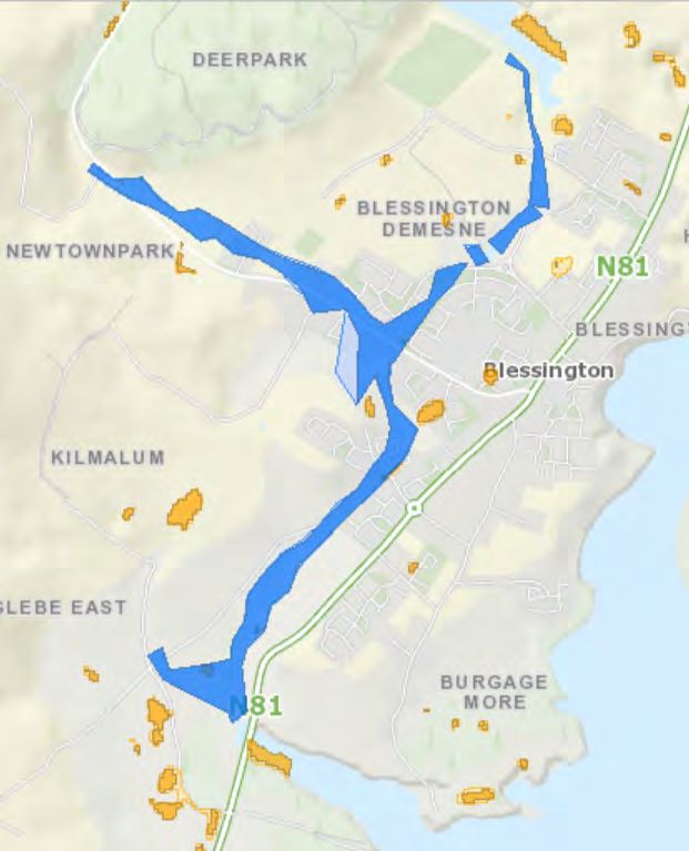
Map 1—Environmental and Landscape Features

                                             8
9

River Liffey, and it provides a ‘natural’ edge and defining feature in the
town and limits growth and expansion eastwards.
The Poulaphouca Reservoir is a designated Special Protection Areas (Site
Code 004063). The site is of national importance for its population of
Greylag Goose (Anser answer), which is one of the largest in the country.
The site provides the main roost for the birds, with feeding mostly on
improved grassland outside of the site and particularly lands in the Three
Castles area. A range of other waterfowl species occur in relatively low
numbers, including Cygnus Cygnus (Whooper Swan), Wigeon Duck (Anas
Penelope) and Common Goldeneye ducks (Bucephala clangula). The res-
ervoir attracts roosting gulls during winter, most notably a large popula-
tion of Lesser Black Headed Gull (Larus fuscus), which in Ireland is rare in
winter away from the south coast. The inlet near Glebe East supports
significant numbers of waders and ducks.
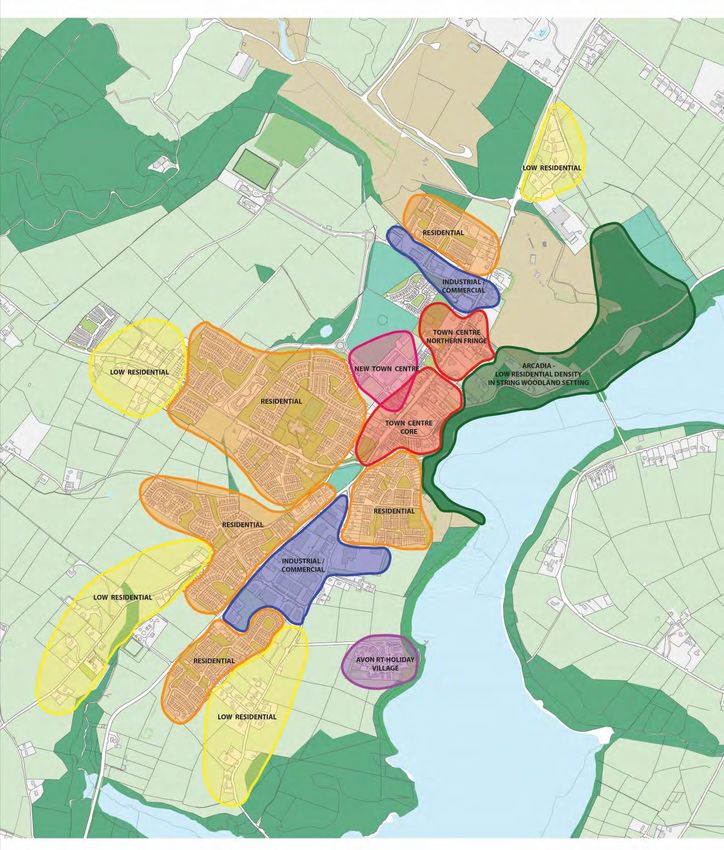
The lakes are a significant amenity, providing opportunities for boating,
sailing, competitive rowing, angling, windsurfing, kayaking and canoeing.
Although, this continuous and expansive waterway is one of the most
significant amenities for the town, and at its nearest point it is just 200
metres from the Main Street, the physical and visual connection and with
the lake is rather weak.
The stream system to the west of the town, at first may seem insignifi-
cant and small and not more than a drain, but closer inspection reveals
that it is an important landscape feature. It would appear that stormwa-
ter run-off feeds the stream with silt accumulation on the stream bed,
however, the reeds associated with the small wetland and pond at Bless-
ington Demense filters some of the sediment resulting in clearer waters
running south between the housing estates of Glenview and Kilmalum
where it then is culverted for a distance of 350m or so before emerging
again after the roundabout on the Kilmalum (Ballymore Eustace) Road.
Minnow have been observed in the stretch between the pond and the
Kilmalum Drive. The pond itself hosts moorhen, mallard and herons,
while snowy egrets have been also been observed at the pond and both
above and below the culverted section. This would indicate that the
stream is ecologically significant.
The OPW have identified areas of flood risk in Blessington (Map 1B page
11). The riparian corridor associated with this stream course is identified
as a flood risk area. It would appear too that another stream from
Glending Valley/Newtown Park feeds this stream but has been culverted
from the housing estate at Glending Way to somewhere in the vicinity of
the Ashton Estate. This area is also identified as a flood risk area.
Future urban development in the vicinity of these streams is likely to
significantly increase the rate of run off and if any of the culverted sec-
tions got blocked there could easily be surface water flooding in existing
residential areas as highlighted on the Draft OPW Flood Map. Such an Photos: These photos follow the stream course on
event already occurred on the 24th October, 2011. the west side of town; it is a rich ecological corridor
The undulating nature of the landscape, combined with strong hedge- that commences north of the GAA pitch and runs
towards the John Kelly Roundabout, then into the
rows and mature tree lined field boundaries assist in absorbing and as-
wetland and pond near Glen View; before flowing
similating housing development into the landscape. In particular, there
10are very mature beech trees lining field edges in the townlands of
Kilmalum, Newtown and Blessington Demense (refer to the
‘Environmental Parameters Maps’). When the Poulaphouca Reser-
voir was constructed, the banks of the lake were planted with coni-
fers (scots pine, etc.). The lands east of St. Mary’s Church (south of
Haylands) display a number of older period homes, in a low density
sylvan glade. Other significant tree groups include:
Glending Wood - which combines a good mixed woodland in the area
to the west, leading to an expansive mature coniferous plantation in
the middle; and some more mixed deciduous woodland to the south.
Notable species include sparrowhawk, buzzards, jays and long eared
owls; with notable mammals including rabbits, badgers, foxes and
deer. The lower stretch of the woodland along the Naas Road reveals
a significant spread of rhododendron which ideally should be con-
trolled.
The Kilbride Road leading to the Red Lane, reveal a significant wood-
land (predominantly sitka spruce) that screens the gravel pits be-
tween this road and the N81; while there is another plantation along
the western boundary of the N81 adjoining the Roadstone Quarry
Entrance.
The southern most part of the study area also reveals significant tree
groups and woodland areas – a relatively recent plantation of ash and
other species in the wetlands around Burgage More create an alluvial
woodland in this area and the route of the greenway connects it to
the bridge crossing at the inlet and associated wetlands at Glebe East
south between Deerpark Court/Ashton Estates; then
south to Kilmalum Estate, where it is culverted for sev-
eral hundred metres before re-emerging near Blessing-
ton Abbey on the Ballymore Eustace Road where it then
runs south into the townland of Glebe East and flows
under the N81 and into Poulaphouca Reservoir.
11where there are significant groups of spruce and pine trees. Both areas
support good numbers of deer.
Within the town itself, the larger trees are used as rookeries for nesting
and roosting for rooks and jackdaws.
The predominant agricultural activity is sheep and cattle grazing. The
undulating landscaping and farm system is peppered with small ponds
that are frequented in the winter by various species of duck including
wigeon, teal and mallard. Human disturbance from any one allows ref-
uge in the others. In the long term development of the town, opportuni-
ties should be sought to incorporate these ponds and streams into an
overall open space network of meandering linear parks. Some of the less
intensively grazed and farmed fields near the town reveal a greater grass
and wildflower diversity and there are also a few notable damp
(wetland) species rick meadows containing ragged robin, orchids,
vetches, etc. (indeed such species can even be found on the margins of
the N81 on approaching the town from the North).
Overall, the town and its environs reveal a multitude of habitats with a
healthy and diverse range of species of flora and fauna.
Alien Invasive Species
Japanese Knotweed: There are a few locations close to the town where
Japanese Knotweed is growing. These have been noted on the road
verge on the N81 on the southern approach opposite Rocypool Villas;
along a section of the N81 on the Tallaght side and on lands adjoining the
Mountainview Estate.
Cherry Laurel and Rhododendrons: Cherry Laurel exists in the area be-
tween the skateboard park and the broad green verge adjoining Oak
Drive Estate and significant numbers are noted on the northwestern
edge of Glending Woods, close to the Naas Road. Rhododendrons are
present at Blessington Orchard Estate. Both Rhododendron and Cherry
Laurel species are unpalatable and likely toxic to mammals and probably
invertebrates due to the presence of ‘free’ phenols and diterpenes in
Rhododendron and cyanide in cherry laurel species and supports little
wildlife. These species produce a dark sterile environment, which sup-
presses regeneration of native. The upper slopes of the Glending wood
(above the area of Cherry Laurel) encompass areas with native bluebells
and native flora will have difficulties in regenerating itself if the rhodo-
dendrons are not controlled.
Montbretia: Another attractive plant is Montbretia (Scientific Name:
Crocosmia x crocosmiiflora) with its bright reddish-orange flowers
(flowering July – September). It is considered by many to be one of our
native plants, however this is an introduced species and is a hybrid be-
tween two South African species. It appears to like acidic soil and if left
unchecked Montbretia can invade most low-growing habitats such as
wet grasslands, gardens, hedgerows, pastures, waste areas and road-
sides. The biodiversity of ecosystems can be significantly affected by an
infestation of Montbretia. Once established, it out-competes the local
flora and forms large dense stands. The Department of Agriculture, Food
12Photos to left: A series of photos revealing some of the and the Marine have prepared an Invasive Plant Information Note on
species rich meadows as highlighted on Map 1. Montbretia.
The species was identified in two areas during the survey period in
Photo below: A view of the Wicklow Mountains from Spring 2018 – one was a small clump in the rough undeveloped land
Mountain View and Carrig Glen Estate. immediately west of and adjacent to Oak Drive Estate (it is likely that
this has re-colonised by inadvertent dumping of discarded plants; it is
capable of regeneration from corms and small fragments of rhizome).
It was also spotted in a small green (open space) within Lakeside
Downs and appears to have been deliberately planted on the spot.
Action Points/Recommendations:
Opportunities for the Enhancement of Natural Amenities:
There is a significant opportunity to enhance the relationship be-
tween the town and the lake, by
AP1 Developing waterside walking routes and/or trails to connect
with the proposed greenway route north and south of the town. The
greenway is proposed to commence at the Avon Ri Holiday Resort (as
it currently does) and to circumnavigate the lake via Valleymount,
through Ballyknockan, Lacken and returning via the Knockieran Bridge
and entering the town via the Kilbride Road. As the town develops
and expands, it is likely that the lands between the Mountain View/
13Carrig Glen estates and the Avon Ri will be developed and there is a sig-
nificant opportunity to create a linear parks along the waterfront lands,
with a walkway/cycleway/trails that link the vicinity of St.Patrick’s Well
shoreline to the Avon Ri. Connections back into the town should be pro-
moted and developed so as to ensure that the town has every opportu-
nity to benefit from the economic potential from the expected high vol-
ume of visitors.
AP2 Mountain View and Carrig Glen Estate – the adjoining lands in-
cluding the depressed pit area could be considered for one of the follow-
ing (1) enhanced woodland planting; (2) the development of an en-
hanced wildflower meadow (these can be difficult to maintain in the ab-
sence of selective grazing and/or other management techniques); (3) a
community orchard; and/or (4) a community pet farm along the green-
way route. There may be opportunities for the community orchard/pet
farm could be supported by a local Community Employment Scheme.
AP3: St. Patricks Well – the old access lane to the lakeside should be
cleared and resurfaced with a compacted gravel/hoggin material; over-
grown vegetation should be cleared and walls should be repointed/
maintained.
AP4 Maintaining a break in the tree line opposite the rear of Supervalu
Supermarket (or sites in its vicinity) to ensure there are panoramic views
of the lake (this is likely to require engagement and agreement with the
relevant landowner);
AP5: Demsey’s Lane – this is an attractive laneway at the southern end
of the town. Young beech saplings should be planted in this area so that
they will regenerate and replace older trees in time. The woodland floor
should be planted with native wildflower species such as bluebells and
primroses (the native variety of both). The concrete wall separating this
area from Beechdale Estate has been subject to some anti-social behav-
iour and graffiti, so the planting of dense band of holly may counter-act
this. It is noted that the low rubble wall along the route near Dempsey’s
shop was broken and needs to be reinstated.
AP6: Oak Drive Amenity Area: There is an opportunity to redesign and
re-landscape the open space adjoining Oak Drive. The area displays a
significant variety of shrubs and trees but these are planted in a very
discordant way which is difficult to maintain (weed free), despite some
maintenance the area appears untidy and lacks a positive visual impact
(Refer to sketch/photo A).
AP7 Removal of Invasive Species: Educate local communities and
remove the invasive species, particularly the Japanese Knotweed from
the N81 verges and Montbretia species from the site adjacent the Oak
Drive Estate and from the Lakeside Down Estate.
AP8: Invasive species at Glending Wood: Work with the landowners of
Glending Wood and seek funding for the clearing and eradication of the
rhododendrons on the western side of the wood, north of car park on
the Naas Road. A partnership approach to address the issue should be
undertaken between the landowners (Coillte/Roadstone?), the local
Community Employment participants working for the Blessington Tidy
14Towns CE scheme and the National Parks and Wildlife Service. Fund-
ing may be possible through LEADER funding under the biodiversity
pillar of the Local Economic Development Plan.
AP9 Consider a visual information panel displaying the local native
flora and fauna at key locations such as the pond, stream and wet-
land area opposite the Glenview Estate; and at intervals along the
lake shore/St.Patrick’s well (in addition to the future Greenway
route).
AP10: Work with the Men’s Shed to develop bird boxes, bat boxes
and insect/bee hotels for erection on public lands and identified
amenity areas.
Top Photo: An insect/bee hotel on the grounds of
Flood Mitigation Measures: In order to counteract localised flooding,
Supervalu.
it is recommended that the following proposals are implemented:
AP11 No section of the stream corridor to the west of the town cen-
Photo top left: A view of the old gravel pit near Carrig
tre is to be culverted except in exceptional circumstances such as new
Glen Estate.
road crossings, and even in such areas bridging is preferred to cul-
verting and where installed culverts should be significantly wider than
Photo middle left: A mown path provides access to the the existing stream width.
Blessington Lakes and provides an opportunity for incor-
poration into the proposed Blessington Greenway net- AP12 There should be a generous set-back from future development
work. in the vicinity – a minimum of 10m either side but regard should be
had for the local contours and should be seen as an minimum guide-
line – this area should be developed as a continuous linear park and
Photo below left: The lane leading to St. Patrick’s Well ecological corridor – interconnected between developments (where
and onto the Blessington Lakes. possible).
AP13 Additional storm water attenuation/retention features, par-
ticularly ponds and constructed wetlands, should be developed along
the stream course – particularly before the Kilmalum Drive area, but
also future development lands to the west of the stream that feed
into it.
These measures will not only add to the amenity of the area, but also
should be seen as practical measures in the provision of ‘green infra-
structure’ and will go some way towards combating the impacts of
climate change and adverse weather events.
15Chapter 3—Land Use Survey and Assessment
Objective:
To identify the most vibrant areas of the town/village and in particular
to focus on the weak areas where vacancy is most prevalent.
The land use map shows the current land use in the town (May 2018). It
should be noted that the land use survey relates solely to the ground
floor areas (the upper floors were not surveyed as the predominant use
is on the ground floor level). This map could be used as a baseline study
to allow comparative trends over subsequent years – i.e., to determine
whether the vacancy rates along the Main Street increase or decrease.
The town centre is a relatively small area that extends along the Main
Street from the Maxol Service Station (junction with the ring road) in the
north to the junction with the Naas Road to the south. The length of this
area is approximately 800m – which represents a very walkable area.
The retail units (coloured red) and the commercial units (coloured or-
ange) are the most vibrant parts of the town and these units are well
distributed throughout the town centre. The larger convenience shops
are key generators of activity in the town and the key anchors in this
regard are Supervalu in the centre of the town on Main Street; Aldi at
the northern end of Main Street and Dunnes in the modern shopping
centre just behind Main Street. Retail activity in the town displays a
good variety of other uses such as butchers, health foods, pharmacy, gift
shop, florists, jewellers, a bookshop, hardware store and a specialist
camping and caravan store.
There are also two banks in the town, two service stations, one news-
agent-smaller convenience shop, a range of pubs, cafes and fast food
outlets. While there are two or more pubs offering evening meals, there
is otherwise a dearth of standalone restaurant open during the evenings.
The Downshire Hotel has been closed for a good number of years and
there is no accommodation in the town centre either.
The land use maps reveal a reasonably good range of uses in the town,
particularly for a town of its size. The main public/institutional uses in the
town include the Church of Our Lady, the Church of Ireland, St. Mary’s
National School, St. Joseph’s Hall and St. Kevin’s Hall (which are used by a
variety of community groups and sporting clubs). The environs display a
good range of primary education facilities with the No.1 School, the Edu-
cate Together School and the Gaelscoil (temporarily housed in pre-fabs
on the old Ballymore Eustace Road). There is a modern public library at
the new town centre development. There is a good range of sports and
recreational facilities, notably the GAA grounds (with all-weather astro-
turf), soccer club, boxing club, in addition to martial arts/kick boxing,
cycling club, a junior rugby club, a canoe club, boating club and sailing
club. Some of the woodlands in the local and broader environs are used
for mountain biking.
Apart from the northern end of Main Street, residential use is rather
sparse on the street and many of the older residential properties have
been vacated. Indeed vacancy (highlighted in black on the Land Use
Map) is fairly significant particularly (and ironically) in the very centre of
16Photos to left: Image of uses on the traditional streetscape (top) and the new town centre (below).
MAP 2: Town Centre Land Use Map
17the town – between Supervalu and Dunnes; but also in and around the
vacant Downshire Hotel and further south on Main Street in the area
opposite Dempsey’s. It is hoped that the recent sale of the Downshire
Hotel will lead to new and vibrant uses in this area. A key challenge will
be to encourage new uses and adapting older buildings while maintain-
ing the intrinsic character of the area.
The Main Street now competes with more modern accommodation in
edge of centre locations (such as the Polish shop in the Aran Centre; the
smaller retail units at the Dunnes Shopping Centre and even other uses
such as auto parts and veterinary clinics in what might be considered
‘industrial sites’ around the town). A discussion with the Town Team
around conservation, planning, rates and car parking standards along the
Main Street should be initiated to ensure that obstacles to redevelop-
ment are minimised and to ensure there are clear expectations for pro-
spective developers and/or business people thinking of investing in the
town.
An annual survey of vacant and derelict sites along the Main Street may
be warranted so as to monitor if improvements and/or deteriorations
take place and this might allow a discussion around what interventions
might be considered.
The land use map highlights the fact that there are deep plots on the
western side of the Main Street with significant levels of under-
utilisation, vacancy and brownfield sites. There has been some recent
residential development in the rear of these plots creating new frontage
onto the lakefront and Kilbride Road. Unfortunately, without a coherent
approach in the form of a site development brief or design guidelines the
pattern of development is slightly haphazard in terms of design, building
line and overall building form.
Car parking in the town centre is predominantly on-street car parking
and there would appear to be a relatively high turnover of occupancy of
car parking spaces. Off street car parking, while limited, can be found at
the new Blessington Town Centre (by Dunnes) where there is both a sur-
face car park and a multi-storey car park; there is also a smaller public
car park adjoining the vacant Health Centre, less than 1 minute from the
Main Street. Car parking is free throughout the town.
There is no formal town park in the town centre, though there is a signifi-
cant – though perhaps under-utilised amenity in the centre in the form
of the green in front of St. Joseph’s. with some design interventions
(such as the removal of the low wall) – a more open and active park
could be provided – with the cooperation and in consultation with the
local residents (Refer to last section of the plan for proposals).
18Map 3: Land Use Character Areas
19Chapter 4—Building Condition and Redevelopment Opportunities
Objective:
To identify where the building fabric appears to be deteriorating or
weak, so that sites can be identified in a systematic, unified and holistic
manner and targeted for specific interventions (such as a ‘cosmetic’
lift/public painting initiative or for inclusion on the Council’s derelict
site register and/or targeted for other interventions).
All buildings along the Main Street and secondary streets would be sur-
veyed and marked for a cursory, external visual inspection as either in
Good, Fair or Poor Condition. Various intervention measures can then be
considered in terms of approaching land owners, public initiatives or
inclusion on the Derelict Sites Register. Like the Land Use Survey, the
study could be used as a baseline study to determine trends over subse-
quent years.
In general, the building condition survey reveals that most of the build-
ings along the Main Street are in good condition, with the vast majority
falling into this category. Overall, one’s perception of the town is posi-
tive as dereliction and decay are not readily apparent. However, there MAP 4 —Redevelopment Opportunities
are a number of buildings in fair or poor condition, however, the num-
bers are small and they are peppered along the Main Street and side
streets without any obvious concentration in any one area. However, on
closer inspection, it is clear that there are four or so buildings close to
Supervalu – two opposite and two close by on the same side of the street
– which could do with regeneration with new uses. A planning permis-
sion has recently been submitted for one of these sites, the former Mo-
tor Factors site and the Tidy Towns Committee have also earmarked
some of these sites for repainting which enhances the façade and overall
streetscape.
Also, a key and landmark site in the town of some significance is the for-
mer Downshire Hotel, which is also in fair to poor condition. This latter
site has extensive broad plot width (site frontage) and extends deeply in
a L-shape fronting onto the Lakeside Road, with significant redevelop-
ment potential.
Plot widths are relatively narrow being in general 5-8 metres in width,
though some amalgamation has taken place over the years with plots
double this evident in places. In terms of plot depth, there is significant
variety – with depths of c. 50m evident along the centre of Main Street
backing onto the Blessington Town Centre Car Park; but deeper plots
south of this between the Ulster Bank and Dempsey’s (between 75 –
110m). The opposite side of the street also displays a variety of plot
depths of similar range, however the deepest plots are found between
the former Downshire Hotel and the Supervalu supermarket, where
depths of 125 – 175m are evident. There has been some redevelopment
in this latter area with a mix of single houses, at least one apartment
development and various uses ancillary to the main commercial func-
tions.
20There is significant redevelopment potential in these areas, but there
is a need for a more coordinated approach to the development of
some of these areas, particularly where they are likely to have an
impact on the public realm. Of the following areas, the first two in
particular, have been identified as being of particularly significance in
terms of the potential prominence:
The backland area fronting onto the surface car park at the Blessing-
ton Town Centre development – here there is an ideal opportunity to
create a new street frontage, with active uses and/or dual frontage
Photo (above): Example of poor building condi- (to current uses fronting the Main Street).
tion on the Main Street. The backlands (rear of plots) from the Downshire Hotel to the Super-
valu site – overlooking the lake. There is an opportunity to create a
new building line and street front along this area, while having regard
to existing residential units.
The larger plots to the rear of the Garda Station and Ulster Bank
which also adjoin a larger square shaped site opposite the Dunnes
Stores development.
MAP 5 —Building Condition Map
21Chapter 5—Public Realm Analysis and Townscape Management
Objective:
To identify the intrinsic character of the streetscape (buildings) in the
town centre including vernacular features such as the granite door and
archway surrounds. Key/focal buildings and sites, landmark buildings,
buildings of character will be identified – with possible design interven-
tions to protect and/or improve the area; and to review the public
realm to determine if the quality of the streetscape within the control
of the Council is adequately maintained – the focus would be on foot-
paths, kerbing, public litter bins, signage, wirescape, treescape, etc.
4.1 Historical Development and overall Building Form
Blessington Town is a landlord town, developed initially by Michael
Boyle, Archbishop of Dublin, Primate Archbishop of Armagh and Lord
Chancellor of Ireland. (The town’s development which commenced
around 1667 is linked to two families – the Boyles and the Hills - the lat-
ter were more generally known as the Downshires). Boyle was granted a
royal charter to establish a new town and developed a demesne and
deerpark, richly planted with a variety of trees, extending to over 440
Irish acres (though the estate itself extended to some 10,500 Irish acres
or 17,000 statute acres). By the late 1700s the town had been inherited
by the Hill family (one of the wealthiest landowners in Ireland and Eng-
land) but the town had failed to expand as hoped and perhaps as a result
of the practice of an absentee landlord and then following the 1798 Re-
bellion.
In her book, ‘The Blessington Estate’, Kathy Trant highlights the fact that
–
‘the layout of the town as we know it today, the road frontage of most of
the houses and the dimensions of the accompanying sites have their ori-
gins in the plans drawn up by the first Marquis of Downshire in the 1780s
which continued to be implemented by the second Marquis. The en-
trance to Blessington House, opposite St. Mary’s was recessed, thus cre-
ating the present town square…’
Typical with most landlord or estate towns it has a wide Main street. It
runs in a general north-south axis. St. Mary’s Church, the Church of Ire-
land building in the centre of the town was built on the axis with the for-
mer estate entrance to the west of Main Street (interestingly the Catho-
lic Church was at Crosschapel, 3 kilometres outside the town). Opposite
the Church is situated the former Market House (the current Credit Un-
ion Building) which was built in the late 1830s (and originally included a
magistrate’s assembly room and a jury room on the first floor) and a
number of other buildings which are setback from the Main Street and Photos—Top: Historical view near Town Square
define a ‘market square’ as the heart of Blessington. A forge also was looking south.
situated on the square. Today, a granite monument to the Earl of Hills- Middle: A view of St. Mary’s Church from the
borough (1865) together with the four granite balls at the base of the Credit Union building (former Market House).
lime tree are notable historical features within this space along with
Bottom: View of the Credit Union Building
some of the more impressive historical buildings of the town.
22This area includes some fine townhouses (notably the former Down-
shire Hotel and Ulster Bank Building, a former inn) and although they
are only two storeys in height, they are notably bigger in height and
scale when compared to the typical two storey form of the Main
Street.
Longfield’s Map of the town in 1806 (refer to Kathy Trant’s The Bless-
ington Estate 1667 – 1908, p.126-7) shows that the large plots of land
were assigned to various prominent families and were subsequently
subdivided into smaller building plots. Interestingly, it shows that the
site boundaries were splayed heading towards Dublin to create a
broader space marked as ‘Fair Green’ which no longer exists and was
subsequently redeveloped as a wide street as we know it today. The
building lines are typically straight along Main Street with just a few
subtle deflections in the vicinity of Dempsey’s at the end of the street
and in the vicinity of Supervalu in the heart of the town.
The building lines and rather uniform heights define the street and
provide a good sense of enclosure throughout much of the Main
Street. At St. Joseph’s Square/Terrace the mature street trees pro-
vide a strong edge treatment and sense of enclosure and continuity
of form. However, there are a greater variety of buildings in terms of
their age, land use, character and set-back in the northern fringe of
the Main Street. This area also includes two service stations whose
scale and materials are inappropriate and out of character with the
Main Street.
4.2 Heritage Features
Map 6 displays the Record of Protected Structures and the Architec-
tural Conservation Area (from the Blessington Local Area Plan, 2013-
2019) and also those other buildings and features identified in the
National Inventory of Architectural Heritage. Most of these features
are present in the southern end of Main Street, between the Church
of Our Lady of the Most Holy Sacred and the junction with the Naas
Road. Some of these buildings, such as the Tollhouse, date from
1810. There are also mile markers noted in the town (on N81 leaving
the town). The Urban Design Appraisal Map (Map 7) identifies a sig-
nificant number of additional heritage features from the streetscape
highlighted. These include specific features that exist within the pub-
lic domain and/or define its edge within the streetscape – such as
granite flagstones within the footpaths, granite plinths, granite kerb-
ing, granite pillars, a stile and archways. In addition, there are door-
ways, fanlights, porticos and window sills all made of or defined by
Top Photo: Four Ball Tree at the Square.
granite. There are also traditional wrought iron gates and rubble
Second Photo from Top: Horseshoe Archway, at a for-
stone walls. These features enrich the character of the place and are
mer Blacksmith entrance c.1810.
evidence of the local vernacular materials, notably the former granite
Third Photo from Top: Single Storey Cottage at the quarries from Ballyknockan and its environs. Traditional doorways
North End of Main Street. have panelled front doors, chimneys with coraballed caps and clay
Bottom Photos: Typical Granite Door Surround and pots; two over two timber hardwood sash windows; natural slate and
wrought iron gate—a sample of some heritage features cast iron rainwater goods; and semi-circular radial fanlights over
that add character and richness to the streetscape. doors.
23Map 6—Building Heritage.
244.3 Record of Protected Structures:
The Local Area Plan identifies the following structures for protection:
96 The Rectory
97 Blessington Main Street
98 Main Street, Downshire Hotel (top photo)
99 Main Street Credit Union House (photo previous page)
100 Main Street, Church of Ireland (photo previous page)
101 Main Street, Former Catholic Church
102 Dempsey’s, Main Street
The Local Area Plan also identifies an Architectural Conservation Area
(Refer to Map 6. ACAs comprise of groups of buildings and/or other
features that collectively add to the character of the area and it is
generally focused on the exterior appearance that is to be protected
in particular. ACAs can include areas which add to the appreciation of
a Protected Structures as the setting is an important part of its char-
acter.
Top Photo: The Downshire Hotel (RPS) Photo (above): Dempseys, Main Street (RPS) - part of the
Architectural Conservation Area.
Middle Photo: Ulster Bank (RPS)
Bottom Photo: The Forge (NIAH)
25At ‘the square’ and along the footpaths to the south, there are tradi- Photos Below display a variety of street lighting in
tional granite kerbs, but elsewhere along the Main Street, more modern the town, both neo-traditional, modern, attractive
concrete kerbing predominates and in a number of cases this is broken and utilitarian. There should be greater consis-
or chipped from vehicles in the areas around street trees. tency along the Main Street.
Some of the Heritage Features could form part of a Heritage Trail in the
town and incorporated into a social history of the area. INSERT AS A BOX
4.4 Street Width
The street is widest in the Town Centre Core (refer to Map 7) but starts
to narrow in the vicinity of the Catholic Church and St. Josephs (leading
to the Northern Fringe of the Town Centre). In the core, the street is so
wide as to allow for car parking perpendicular to the kerb on both sides
of the street, whereas it is limited to one side of the street in the north-
ern fringe of the town centre. Perpendicular parking allows for an in-
creased capacity and intensity of on-street parking than what might be
available in areas of parallel parking.
4.5 Street Lighting
It is noted that there are a variety of street lights present along the Main-
street – there are at least two different types of neo-traditional street
lights in the vicinity of the Square, but close by there are traditional poles
without any lighting fixtures outside the Downshire Hotel and further up
the street there are more utilitarian street lights of galvanised steel and
also lights affixed to timber utility poles. A more consistent and uniform
street lighting would be desirable, would reduce the ‘visual clutter’. A
consistent design, preferably one that has a neo-traditional or modern
design that is in keeping with the character of the streetscape, would be
desirable.
4.6 Wirescape and Utility Poles
The presence of overhead wires is a very visually intrusive element of the
streetscape and is particularly evident on the east side of Main Street.
The undergrounding of the wires would allow an opportunity to redesign
the paving, kerbing, street lighting and provision of street furniture. In
addition, it was noted that in an Access Audit in 2008, the fact that
downpipes from gutters along Main Street emit water across the foot-
paths and that this is potential slip hazard to pedestrians particularly if it
were to freeze over; so this issue could also be addressed simultane-
ously. It is noted that there are numerous poles situated in what are
designed as parking bays, limiting their use; these could have been inte-
grated into the footpath and with other kerbed areas. It is also noted
that there are old lamp stands in front of the Downshire Hotel with no
lamp heads – again, additional poles which are unnecessary and/or not
functioning should either be repaired or removed to reduce clutter.
26Top Photo (below): Strong tree group on west side of 4.7 Street Trees
Main Street.
The street trees in Blessington are another very important character-
Middle Photo (below): Poorly cropped trees on the east istic of the streetscape and one of the most notable features within
side of Main Street due to overhead utility wires. the town. The location, distribution, species, age and general condi-
tion of street trees has been surveyed and examined. There is no
uniformity of street trees evident, rather a variety of species have
been planted over the years, with lime, oak and sycamore being par-
ticularly common, interspersed with the occasional chestnut, maple,
cherry and birch species. The northern end of Main Street has a
more discordant building line, more detached buildings and single
storey buildings and the sense of enclosure found elsewhere along
main street is not as evident, yet the predominant species here is
Rowan, which while attractive, has a weaker form and structure than
lime, sycamore or oak which predominate further south. Any redoing
of paving should consider the either supplementary planting in this
area and/or replacement planting.
The negative impact of overhead wires has led to the cropping and
butchery of trees by the electricity supply company and/or their con-
tractors and an uneven and weakened form on the eastern side of
Main Street. This is less evident in summer months during full foli-
age. It is highly desirable to have these overhead wires replaced un-
derground and this would afford an opportunity to remove dead and
live tree stumps that are evident in the area and to consider the re-
moval of existing trees and their replacement with new species or a
more uniform planting along different sections of the street (the re-
moval and replacement of existing trees can stir emotive reactions
but has been successfully achieved in O’Connell Street and along the
Churchtown Avenue in Dublin with very positive end results). If the
older trees were to be removed, then this will lead to a loss of some
amenity and character, at least in the interim, however examples
from O’Connell Street and Churchtown Avenue in Dublin both show
how the new tree planting arrangements can quickly establish them-
selves with a resulting arrangement that can be as good if not better
than the earlier planting scheme. A key recommendation would be
to establish a greater consistency and uniformity in the tree species
chosen along the Main Street, at least along sections of the street,
such as from one junction to another or from one landmark building
to the next junction.
Advice of a landscape architect and/or tree surgeon should be sought
in this regard and as part of a more detailed design process. While
the cost of undergrounding of wires is expensive, this would allow an
Bottom Photo: Tree stump on the east side of Main
opportunity to redesign the kerbed ‘islands’ with the provision of new
Street—with rejuvenated growth which needs to be
streetscape furniture such as lighting, street seating, bike racks, etc.).
removed.
Another alternative to undergrounding wires would be to investigate
the costs of removing poorly formed trees and their replacement
with more formal planting of lime trees like what was done on O’Con-
nell Street, where the entire tree crown can be kept tightly and
evenly trimmed in a box profile.
27Map 7
Urban Design Appraisal Map
28Photos to Right:
Top: Inappropriate scale of signage within town centre; poor sense of
enclosure on streetscape.
Middle: Lack of enclosure—opportunity for new street front.
Photos:
Far Left: Examples of quality urban design—new pav-
ing and quality street furniture.
Mid Left: Historical Monument adds character and a
focal point to the Square.
Immediate Left: Granite Portico at Garda Station and
granite flagstones further up the street, add character
and a sense of place, from the use of local natural mate- Photo—second from bottom: broken kerbing on North Main Street.
rials.
Bottom photo (above right): Focal Site—key site at junction with ring road.
29Tree guards – there are damaged tree guards near the AIB bank on the
Manor Kilbride Road and also in the vicinity of the Credit Union/entrance
to new town centre. These should be repaired and reinstated.
At the base of many trees along the Main Street, specifically where these
are situated on kerbed islands, there are weed barriers showing through
pea gravel. The pea gravel is easily dislodged revealing the weed barriers
which are not deep enough and not covered to a sufficient depth. This
creates an untidy appearance. It is suggested that the weed barriers
should be reinstated (deeper) and that a hoggin material is used to re-
place the pea gravel. Hoggin is a compactable ground cover that is com-
posed of a mixture of clay, gravel, marble and granite chip, which pro-
duces a lovely buff coloured compacted surface.
4.8 Street Furniture
Street furniture is the term that is used to describe the numerous ele-
ments that are placed on the street/footpaths for public use and amenity
and typically include street seating/benches, bins, planters, bicycle racks
and tree guards.
A few observations can be made in relation to street furniture in Bless-
ington. In general, there are two types of bins are in use, the ‘black
bin’ (see photos on opposite page—top right and centre) which is found
on the Main Street and the Omos stainless steel bin associated with the
newly landscaped areas around the ‘new town centre’ (there is a one-off
plastic blue bin noted in the park associated with the St. Josephs housing
development in the centre of the town). The different types of bin in
different character areas is acceptable but the more modern bin type
would look well on the Main Street too.
There is limited street seating in the town centre, with the provision of
just one granite bench in front of St. Mary’s Church. Bicycle parking/
racks are limited and provided at just one location – on the east side of
the central pedestrian crossing in the town centre. There is scope for
additional bike racks and seating along the Main Street.
Post boxes are provided at three locations along the Main Street (Refer
to the Urban Design Map 7) and at one of these locations a traditional
box stands alongside a more modern design.
There are timber flower planters along the Main Street – mostly inserted
on the kerbed islands where mature trees have been removed. Bollards
are limited but noted in the area south of Dempsey’s on the west side of
Main Street. Many of these bollards are missing the reflective bands.
Overall, much of the street furniture – particularly the bollards, bins, bike
racks, post boxes and bus stop signs are dirty and need of power-hosing
and/or cleaning and there are a few that may benefit from spray-
painting.
A particular noteworthy street furniture element that is evident on the
street is the proliferation of sandwich boards used to advertise local
shops, cafes and restaurants. In limited and singular use these can be
30attractive and non-intrusive, but where multiples appear they can
lead to visual clutter on the streetscape and are also a significant ob-
stacle to visually impaired persons. In some cases, business owners
have developed a double height sandwich board which is chained or
strapped to the adjacent street trees and these are even more visu-
ally intrusive. In other locations, there are businesses with 3 or more
sandwich boards outside the one premise. It should be noted that
the Wicklow County Development Plan, 2016-2022 (Development
and Design Standards, Section 5, Retailing) states:
‘Sandwich boards will not be permitted as they can give the appear-
ance of clutter in the townscape and can be a hazard to the disabled
and visually impaired if not carefully designed and positioned’.
There are a number of salt boxes (dispensers) provided along the
Main Street. These bright yellow plastic bins/boxes, while functional,
detract slightly from the traditional streetscape character, but their
number is limited. If there were plans to increase the number of
these in the future, design and location should be carefully consid-
ered.
It is noted that in the Summer of 2018, a number of flower planters
were introduced along the Main Street. These were in timber,
painted black and provided good colour, though ongoing mainte-
nance is likely to be an issue.
Although not strictly part of ‘street furniture’ it is noted that some
trees along Main Street still have Christmas lighting decorations in
place well into the year and this unseasonal element adds to the vis-
ual clutter.
9 Vistas and Views
From the Main Street the topography slopes eastwards towards the
lake and westwards towards the by-pass before gradually rising to
the hills in the east (to include the ridge along Glending Woods). The
rich agricultural hinterland, with undulating countryside and signifi-
cant mature trees and hedgerows means that it absorbs urban devel-
opment rather easily. In general, the town has maintained a strong
‘urban (village) – rural divide’, so that the development is limited
west of the by-pass. This presents good vistas to the more elevated
Glending Woods and the adjacent hills from the streets and roads
that run west from Main Street. From the Square and the new town
centre there are ‘Glimpse Views’ of this countryside.
Likewise, from the countryside there are some focal views of the
landmark buildings in the town, notably St. Mary’s Church of Ireland
Photos: Example of street furniture in Blessington—
tree guards, planters, seating, post boxes, litter bins and building (see photo C).
sandwich boards and free standing advertising. From the Manor Kilbride Road east of the town centre and from the
vicinity of the Supervalu Car Park there are very good vistas over
Blessington Lakes and beyond to the Wicklow Mountains.
314.10 Townscape Management
Townscape management means the tending and care of the whole town-
scape as a permanent cultural asset of society and is focused on manag-
ing changes in an appropriate manner as opposed to simple conservation
or preservation.
The success of towns like Westport in the Tidy Towns Competition has
been down to the joint efforts of the Tidy Towns Committee and the lo-
cal County Council (and formerly Town Council) and indeed the whole
community. Specifically, a town architect was appointed to comment
and oversee on all planning applications with strict adherence to key
design principles. Similar initiatives have been tried in other countries
where ‘Design Review Committees’ have been established to input and
comment on planning and development applications prior to formal re-
view by the Planning Authority. Such committees are typically formed by
local professionals with an interest in architecture and design, in addition
to local members of the community. Consideration could be given for
trialling such an initiative in Blessington.
Photo (above): Focal view of St. Mary’s Church
from Dempsey’s Lane.
Key Urban Design Proposals:
UD1 Underground the overhead wires and remove obsolete utility
poles – with particular attention to the east side of the street.
UD2 Reinstate Street Trees – review kerbing alignment and ground
treatment at base of trees (pea gravel at present with weed barriers visi-
ble, i.e. around the silver birch outside Supervalu – reinstate with a hog-
gin material in buff colour).
UD3 Review the entire Square in the Centre of the Town – recreate/
redefine The Square.
UD4 Prepare Design Briefs for Key Focal Sites – setting out general
principles in terms of new building lines/building set-backs, car parking,
building heights and forms and linkages (if necessary) to the Main Street.
UD5 Develop the backlands between Dunnes Stores/new town centre
and the Main Street – create a new streetscape.
UD6 Liaise with the relevant landowner to remove or reinstate the
collapsed hoarding from around undeveloped sites – promote reinstate-
ment of fencing.
UD7 Consider ways to maintain the integrity and character of the tradi-
tional streetscape, while allowing the adaptation of traditional buildings
for new and alternative uses, through more detailed design guidelines
and principles.
UD8 Consider the erection of a wall or permanent screen around the
rear of the recycling facility at the new town centre; and re-surface and
address potholes in this area (Review on site again).
UD9 Street sign at corner of Main Street (beside AIB) has been bent
and needs straightening/replacement.
32UD10 Replace or repair the tree guard at the side of AIB on the
Manor Kilbride Road.
UD11 The approach road or Gateways – entry points into the town –
are generally well presented with a green verge and tree lined, how-
ever, there is quite a lot of signage, in addition to painted tyres and
some of it is superfluous. Consideration should be given to surveying
the signage, review/reassess the need (focusing on absolute need)
and removing some of the signage (and the tyre minions) to reduce
visual clutter on the approaches and entrances.
UD12 Promote the views and vistas as identified on Map 8 and keep
vegetation clear to maintain views of the lake.
Photo (above): Site/construction hoarding which has UD13 Consider the redesign and landscaping of the St. Joseph’s Park
rotten and has collapsed and requires follow up with
in the centre of the town. Key considerations here would be to re-
landowner due to health and safety concerns and poor
move the low concrete wall (to provide ease of access and visibility);
general appearance (UD6).
raise up the level within a portion of the park closest to the street and
Photo (below): Weed encroachment on cycle way and introduce some formal planting and seating (Refer to Sketch).
footpaths (near Naas Road Roundabout) - (UD17)
UD14 Reinstate/repair rotting timber fencing at Aldi near the bound-
ary with playground and address exposed weed barrier – ideally it
should be covered with topsoil, peat or bark chippings.
UD15 In advance on any decision on the undergrounding of over-
head wires and repaving (hard landscaping of the street), the weed
barrier in the landscape median outside the Church is exposed and
needs to be covered over with soil, peat or mulch.
UD16 Roundabouts: There are four main roundabouts in and around
the town and in the past year or two, two of these have been newly
redesigned (the one south of the town on the N81 near the Texaco
Station and the one on the Naas Road). At these and at the other two
locations (near the new town centre and at Kelly’s Motors) need to
be adequately maintained in terms of weeds, trimming, pruning and
general upkeep and should be part of a regular maintenance pro-
gramme.
UD17 Along the relief road and on approach roads, significant weed
encroachment is noted on footpaths/cycle lanes and is a significant
problem (it is noted that some efforts have been made to address
this problem during the Summer 2018).
UD18 Promote the installation of new bike stands/parking at strate-
gic intervals along the Main Street and town centre with a particular
focus on the square, close to St. Joseph’s park/the Church, the north-
ern end of Main Street, the new town centre and at the playground.
UD19 Promote the installation of new seating and street benches
close to bus stops if possible and at the town square, St. Joseph’s
Square, the playground and on the landscaped islands along Main
Street.
UD20 Redesign the boundary treatment of the playground along the
Relief Road.
UD21 Engage with Dublin Bus, Bus Eireann, An Post and the County
33You can also read