CARRICK-ON-SUIR REGENERATION PLAN - Part 8 Planning Report
←
→
Page content transcription
If your browser does not render page correctly, please read the page content below
CARRICK-ON-SUIR REGENERATION
    PLAN
    Part 8 Planning Report

    Tipperary County Council

    July 2021

–
CARRICK-ON-SUIR REGENERATION PLAN
Part 8 Planning Report

  Contents
  1.   Executive Summary ................................................................................................................................................4
  2.   Introduction & Description.....................................................................................................................................4
    2.1      Introduction ..................................................................................................................................................4
    2.2      Description of the Scheme ...........................................................................................................................4
    2.3      Scheme Objectives........................................................................................................................................6
    2.4      Previous Planning Applications and Other Proposed Projects ...................................................................6
       2.4.1     Castle Street/New Street Public Realm ...................................................................................................7
       2.4.2     Sean Kelly Square Public Realm ...............................................................................................................7
       2.4.3     Ormond Castle Park Ecological & Amenity Improvement Scheme .......................................................7
  3. Identification of Need .............................................................................................................................................7
  4. Justification for the Project ....................................................................................................................................8
  5. Environmental Assessment Report ........................................................................................................................9
  6. Appropriate Assessment ..................................................................................................................................... 10
  7. Flood Risk Assessment ......................................................................................................................................... 10
  8. Public Services ...................................................................................................................................................... 11
    8.1      Water Supply.............................................................................................................................................. 11
    8.2      Sewerage Facilities..................................................................................................................................... 11
    8.3      Surface Water Drainage ............................................................................................................................ 11
       8.3.1     SuDS ....................................................................................................................................................... 11
  9. Traffic and Parking Impact Assessment .............................................................................................................. 12
    9.1      Summary of Analysis of Traffic Counts and Traffic Modelling................................................................. 12
    9.2      Parking Strategy and Impacts .................................................................................................................... 13
    9.3      Review Bus Parking Zones ......................................................................................................................... 15
    9.4      Crossing Details .......................................................................................................................................... 15
    9.5      Junction Strategy ....................................................................................................................................... 15
  10. Archaeological Assessment ................................................................................................................................. 16
  11. Architectural Assessment .................................................................................................................................... 16
  12. Design Standards ................................................................................................................................................. 17
  13. DMURS Statement ............................................................................................................................................... 19
    13.1     Main Street................................................................................................................................................. 19
    13.2     Laneways and Side Streets ........................................................................................................................ 19
    13.3     North Quay ................................................................................................................................................. 20
  14. Utilities Impacted by the Scheme ....................................................................................................................... 20
    14.1     ESB .............................................................................................................................................................. 20
    14.2     Gas .............................................................................................................................................................. 20
    14.3     Irish Water .................................................................................................................................................. 21
       14.3.1 Water Supply ......................................................................................................................................... 21
       14.3.2 Wastewater Network ............................................................................................................................ 21
       14.3.3 Surface Water Network ........................................................................................................................ 21
    14.4     Public Lighting ............................................................................................................................................ 21
    14.5     Telecoms .................................................................................................................................................... 22
    14.6     Data ............................................................................................................................................................ 22
    14.7     Traffic Lights ............................................................................................................................................... 22
  15. Demolitions .......................................................................................................................................................... 22
  16. Drawings ............................................................................................................................................................... 23
  17. Public Consultation .............................................................................................................................................. 23
    17.1     Main Street Car Park .................................................................................................................................. 24
    17.2     Quay Wall Glass Infill Barriers ................................................................................................................... 24
  18. Conclusions and Recommendations ................................................................................................................... 25
    18.1     Conclusions ................................................................................................................................................ 25
    18.2     Recommendations ..................................................................................................................................... 25

21906_6009                                                                                              ii                                                            July 2021
CARRICK-ON-SUIR REGENERATION PLAN
Part 8 Planning Report

      Tables
      Table 10.1: Predicted 2023 Peak Hour Junction Traffic Volumes ............................................................................. 13
      Table 10.2: Proposed changes to Car Parking ………………………………………………………………………………………………….. 12

      Figures
      Figure 10.1: Overview of Parking in Carrick-on-Suir .................................................................................................. 14

      Appendices
      Appendix A              Environmental Impact Assessment Report

      Appendix B              Appropriate Assessment Report

      Appendix C              Flood Risk Assessment Report

      Appendix D              Traffic Assessment Report
      Appendix E              Archaeological Assessment Report
      Appendix F              Architectural Heritage Impact Assessment Report

      Appendix G              Drawings

      Appendix H              Public Consultation – Poster and Letter

      Appendix I              Public Consultation – Presentation to Councillors

      Appendix J              Public Consultation – Public Webinar & Website upload

      Appendix K              Public Consultation – Main St. Car Park

      Appendix L              Pre-Connection Enquiry

21906_6009                                                                               ii                                                                July 2021
CARRICK-ON-SUIR REGENERATION
Part 8 Planning Report

       Project                                                                              Approved
                         Doc. No.           Rev.      Date      Prepared By   Checked By                    Status
         No.                                                                                   By
                                                                                                            PART 8
       21906     XX01-MWP-ZZ-ZZ-HS-Z-6009   P01    15/07/2021    M Keane      P O’Donnell   P O’Donnell
                                                                                                          VALIDATION

       21906     XX01-MWP-ZZ-ZZ-HS-Z-6009   P01    29/07/2021    M Keane      P O’Donnell   P O’Donnell     PART 8

      MWP, Engineering and Environmental Consultants
      Address: Park House, Bessboro Road, Blackrock, Cork, T12 X251
      www.mwp.ie

21906_6009                                                       iii                                                   July 2021
CARRICK-ON-SUIR REGENERATION
Part 8 Planning Report

      1. Executive Summary
      Carrick-on-Suir on the N24 national corridor has potential as a major tourism and recreational destination
      associated with the Suir Blueway and with its heritage as promoted by Ireland’s Ancient East.

      Carrick-on-Suir has not benefited from increases in revenue associated with the tourism economy in other parts
      of the country. Currently Carrick-on-Suir struggles to attract visitors, pedestrian or cyclist, either to or from the
      town to the Blueway in Sean Healy Park or to or from Ormond Castle.

      The aim of the proposed Regeneration project is to enhance access and the presentation of the medieval core of
      Carrick-on-Suir as a living, social and commercial place. An improved public realm that reinforces the streetscape
      character, and ensures that visitors feel welcome, would attract new business and tourism.

      2. Introduction & Description

      2.1 Introduction
      The proposed development includes for public realm refurbishment and enhancement in Carrick on Suir’s town
      centre comprising the upgrading of existing streets and lanes with new high quality paving, kerbing, public lighting,
      improved street furniture and utility diversions/works (including undergrounding of overhead ESB cables).
      Footpath space will be widened, traffic calming will be developed through build out, reduced road carriage widths
      and improved pedestrian crossings. Existing car parks will be improved and new car parking spaces provided. The
      traffic management at the junction of Main St and Dillon Bridge will change from a signal controlled junction to a
      priority controlled junction. Pedestrian movement will be prioritised by the design.

       The development includes for public realm refurbishment and enhancement at Sean Healy Park comprising the
      development of a new vehicular parking area with entry and exit, footpaths and hard paved areas, widening of
      the Blueway and the development of associated landscaping and services/utilities to serve the proposed and
      future uses. The extension of the Suir Blueway along North Quays to provide cycleway and pedestrian linkages
      from Sean Healy Park to Ormond Castle and the town centre. The upgrading of Strand Walk with new paving and
      the development of a new access to Ormond Castle grounds and closing of the existing ramped access.

      2.2 Description of the Scheme
      The nature and extent of the proposed development is as follows:

             •   New streetscape layout for Main Street with new alignment design for footpaths and trafficked areas
                 incorporating new paving, kerbing, hard and soft landscaping and street furniture.

             •   Alteration of on street parking for Main Street and other Streets.

             •   New surface finishes to laneways linking Main Street to car parks and the Quays and laneways off Main
                 Street.

             •   Demolition of a derelict building on Strand Lane to facilitate development of additional car parking spaces
                 and an improved public realm.

             •   Development of new surfacing and landscaping to Strand Lane/Oven Lane car park.

21906_6009                                                             4                                                 July 2021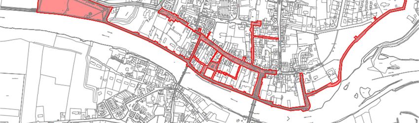
CARRICK-ON-SUIR REGENERATION PLAN
Part 8 Planning Report

             •   Development of a new vehicular carpark at Sean Healy Park adjoining the N24 accessed from the N24
                 and exiting onto Quay Rd.

             •   Upgrade and widening of existing and development of new pathways and hard and soft paved areas in
                 Sean Healy Park. Development of services and utilities to facilitate future development at Sean Healy
                 Park.

             •   Upgrade of surface finishes and alterations to the alignment of footpaths and trafficked areas along the
                 North Quays from Sean Healy Park to Ormond Castle. New builds outs will be developed to calm traffic.

             •   Upgrade of surface finishes and alterations to the alignment of footpaths and trafficked areas along
                 Greystone St and West Gate.

             •   Development of sections of glass infill to North Quay Walls to open views to the river at the south of
                 Oven Lane.

             •   Upgrade of footpaths and trafficked area along Greystone Street and West Gate with new paving,
                 kerbing, lighting etc

             •   Upgrade of footpath along Strand Walk with new paving and development of new access into Ormond
                 Castle Grounds. This involves development of new steps and a ramp and removal of a section of the
                 existing wall bounding the Ormond Castle grounds. The existing ramp connecting Castle Park to Strand
                 Walk to be removed and this access closed.

             •   Development of associated drainage services and utilities

             •   Undergrounding of overhead electrical cables and upgrading of public lighting.

             •   Development of EV parking spaces and associated infrastructure at Sean Healy Park and Strand Lane.

             •   All associated site works.

      The areas included in the Carrick-on-Suir Regeneration plan:

             •   Castle Lane

             •   Pill Road (Strand Walk)

             •   North Quay

             •   Main Street

             •   Barrack Lane

             •   Chapel St./New Lane

             •   Ball Alley Lane

             •   Oven Lane

             •   Strand Lane

             •   Bridge Street

             •   West Gate

             •   Greystone Street

             •   Sean Healy Park

21906_6009                                                           5                                                July 2021
CARRICK-ON-SUIR REGENERATION PLAN
Part 8 Planning Report

             •   William Street

             •   Cook Lane

             •   Rose’s Lane

             •   Hotel Lane

             •   Kiersey Place

             •   Entrance to Heritage Centre

             •   Entrance to Foran’s Car Park

             •   Well Road

      2.3 Scheme Objectives
      The objective of the Carrick-on-Suir Regeneration scheme is to:

             •       Provide a focal point for activity/footfall including improving linkage from the Blueway to Ormond
                     Castle to act as a driver for economic and social growth
             •       Reduce pedestrian/vehicle conflict and improving pedestrian safety;

             •       Reduce vehicle dominance on the main streets and improve junction capacity;

             •       Design the Main Street as a pleasant and safe place to be;

             •       Enhance the appearance of the town centre through careful design and selection of appropriate
                     surfacing and street furniture;

             •       Safeguard the structure and appearance of heritage buildings by reducing the impact of vehicles

             •       Development of enhanced pedestrian and cyclist linkages throughout the town.

             •       Consider opportunities to enhance public realm at night

             •       Develop Sean Healy Park as a water sports arrival point and community amenity
             •       Continue the Suir Blueway from Sean Healy Park to the eastern side of Castle Park, this will support
                     the long term collaborative vision to investigate ways to extend the Blueway eastwards towards
                     County Waterford.

      2.4 Previous Planning Applications and Other Proposed Projects

      Other proposed projects within Carrick-on-Suir include Sean Kelly Square, Castle Street/New Street Public Realm
      and the Castle Park Biodiversity Plan. These projects have all been granted planning. It is envisaged that the works
      to Sean Kelly Square and Castle Lane will be constructed in conjunction with the Carrick-on-Suir Regeneration
      Plan.

      Upgrade works to the N24 are planned to commence in Q4 of 2021 and last approximately 18months (Planning
      Reference P8/19/01), it is likely that part of the N24 works will overlap with the proposed Carrick-on-Suir
      Regeneration Plan.

      The outline boundary for each of the proposed projects as outlined above, are included in the Carrick-on-Suir
      Regeneration Plan drawings for reference.

21906_6009                                                           6                                                 July 2021
CARRICK-ON-SUIR REGENERATION PLAN
Part 8 Planning Report

      2.4.1     Castle Street/New Street Public Realm
      Part 8 Planning, Planning Reference (P8/19/08) was granted for Castle Street, Castle Lane and New Street which
      aimed to improve the public realm and linkage to Ormond Castle and the town along with parking improvements
      to ensure ease of access and navigation for visitors to the Castle.

      2.4.2     Sean Kelly Square Public Realm
      Part 8 Planning was also granted for Sean Kelly Square Public Realm Improvements, Planning Reference
      (P8/18/01). This plan for Sean Kelly Square and Westgate is to function as an attractive amenity area which would
      provide vibrant, distinctive, strong in identity and rich in character.

      2.4.3     Ormond Castle Park Ecological & Amenity Improvement Scheme
      Ormond Castle Park Biodiversity Plan Planning Reference (P8/21/4) (adjacent Ormond Castle) has recently been
      granted planning permission.

      3. Identification of Need
      Carrick-on-Suir is a large rural town, however, it has not benefited from increases in revenue associated with the
      tourism economy in other parts of the country. The central area is cluttered with poor public realm quality.
      Currently the central streets of Carrick-on-Suir do not gain the full potential benefit from the visitors, pedestrian
      and cyclists, travelling either to or from the town to the Blueway in Sean Healy Park or to or from the Castle. An
      improved public realm that reinforces the streetscape character, and ensures that visitors feel welcome, would
      attract new business and tourism. This would give Carrick-on-Suir a role both as a visitor destination and as the
      service town for its hinterlands and communities.

      Carrick-on-Suir is within easy reach of all the larger centres of population in Ireland. The location of Carrick-on-
      Suir on the N24 national corridor from the east (Wexford/Waterford) to the west (Limerick City) supports its
      significant potential as a major tourism and recreational destination associated with the Suir Blueway and with its
      heritage as promoted by Ireland’s Ancient East.

      In November 2016, a two-day workshop was hosted by the Heritage Council and TCC in Carrick-on-Suir. This
      workshop was open to all and its purpose was to collaboratively identify key obstacles for economic and social
      regeneration in Carrick-on-Suir and the identification of ways that these could be addressed. The findings and
      outcomes of the event were compiled and inform the Carrick-on-Suir ‘Solving our Own Problems’ programme. A
      summary of outcomes of the recommendation from this include:

      •        Need for a focus on the Main Street to become a desirable destination

      •        Need for widening of footpaths on the Main Street to provide for a more pleasant shopping environment

      •        Create more desirable weekend experiences i.e. with the Castle as a hub of activities

      •        Need to identify the town’s assets i.e. the River Suir, the Marina, Ormond Castle, the Greenway, Cycling,
               etc.

      •        Need to sell the town as a destination spot for day trippers using programmes and initiatives such as the
               Butler trail, The East Munster way, the Suir Blueway, etc.

      •        Need to improve traffic flow on the Main Street as part of public realm enhancement

21906_6009                                                           7                                                  July 2021
CARRICK-ON-SUIR REGENERATION PLAN
Part 8 Planning Report

      •        Improve awareness of parking options and orientation in general

      •        Better definition of town centre and central area zones

      •        Need to improve the environment for cyclists

      •        Need to improve access to Ormond Castle

      •        Reduce dereliction and improve accommodation in the town centre

      •        Develop pedestrian friendly zones in key locations with special emphasis on the historic commercial
               spine of Main Street

      •        Continue the Greenway route into the core of the town where there should be facilities provided at the
               terminal point.

      The Carrick-on-Suir Regeneration Plan proposal for Carrick-on-Suir actively draws on the ‘Solving our Own
      Problems’ programme.

      4. Justification for the Project
      The town has a wealth of untapped tourism and heritage resources which are ripe for development including:

      •        Ormond Castle and Ireland’s only Tudor Manor House

      •        The River Suir with its Marina and amenities

      •        The Heritage Centre

      •        The Historic Lanes

      •        Part of the original Town Walls

      •        14th Century Old Bridge

      •        St. Molleran’s Church and graveyard
      •        Butler Trail

      •        The Munster Vales

      The Carrick-on-Suir Regeneration Plan will primarily deliver the following two elements:

      1.       Design and Enhancement of the Suir Blueway at Carrick-on-Suir and Sean Healy Park

      The Suir Blueway Tipperary is a 53km walking, cycling and watersports trail stretching from Cahir to Carrick-on-
      Suir. Carrick-on-Suir forms the eastern focus of the Suir Blueway and has an important role in services provision
      and in the visitor experience of the area. It is proposed to prepare a design, enhancement and orientation scheme
      from Sean Healy Park that will consider best practice in user needs i.e. kayakers, cyclists, walkers, this will extend
      along the quays. An arrival point will be created at Sean Healy Park and an integrated approach to way-finding
      (paving, interpretation, lighting, technology, etc). linking the Blueway with the Town Centre and Ormond Castle
      Quarter.

21906_6009                                                            8                                                  July 2021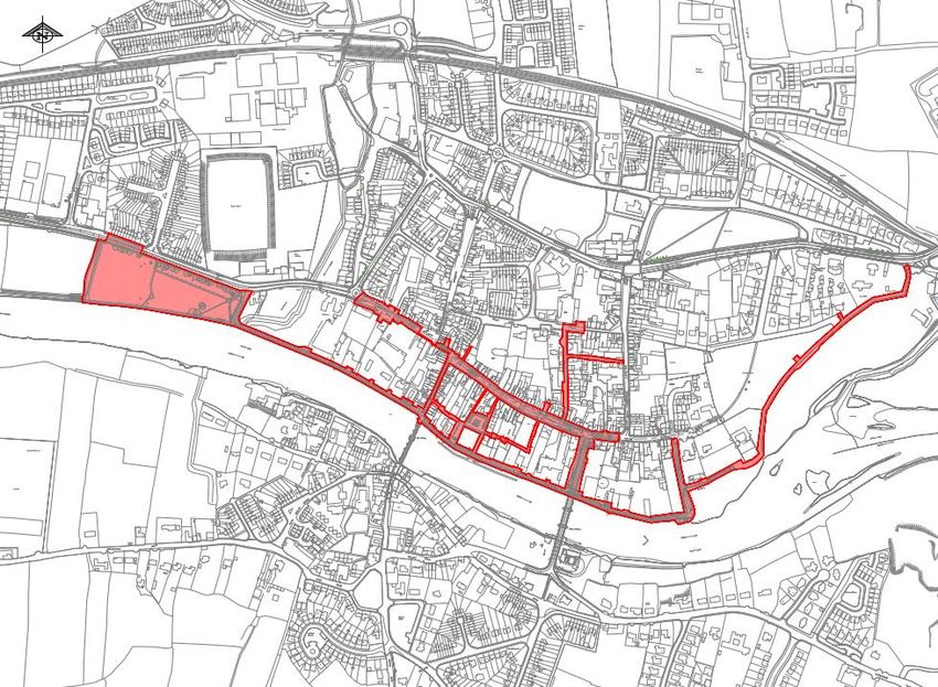
CARRICK-ON-SUIR REGENERATION PLAN
Part 8 Planning Report

      2.       Regeneration, design and enhancement of the central area and public realm

      The Main Street is the central spine of the town and forms a direct link between Ormond Castle Quarter and Sean
      Kelly Square; this is the commercial, social and cultural hub of the town. The town centre will be uplifted to
      become a pleasant place to be, through the development of pedestrian friendly ‘zones/character areas’ and
      enhanced way-finding i.e. through paving, interpretation, lighting, etc. A high quality public realm and review of
      opportunity sites and synergies in terms of their regeneration will also be incorporated with solutions developed
      collaboratively.

      This regeneration element shall include enhancement of the central core and amenity improvement for Sean
      Healy Park and linkages with Town centre. The regeneration plan is focused on the central area in the strong town
      of Carrick-on-Suir. It is expected that significant investment in the core of the town, using its strongest assets, will
      further consolidate development by stimulating growth and employment, and reducing vacancy and dereliction.

      This tourism based regeneration plan is timely for Carrick-on-Suir as it will benefit from synergies with a range of
      recently developed and launched, regional and local tourism initiatives including Ireland’s Ancient East, the Suir
      Blueway, the Butler Trail and Munster Vales. The tourism economy in the area has already benefited as can be
      seen by increased numbers coming from the Suir Blueway, and resulting in new businesses such as bike hire,
      Carrick-on-Suir Artisan Hub, etc.

      This plan will enhance the overall liveability and amenity of the central area, identify local buildings and features
      of specific character i.e. Ormond Castle in the town and in particular, enhance the setting of the existing built
      heritage of the town.

      5. Environmental Assessment Report

      Carrick-on-Suir Regeneration Plan was subject to an Environmental Impact Assessment Screening in accordance
      with the EIA Directive (Directive 2011/92/EU as amended by Directive 2014/52/EU.

      The Environmental Impact Assessment Screening Report(EIA) is included in Appendix A and noted that it is not
      considered that the proposed Carrick-on-Suir Regeneration Project works will result in a significant negative effect
      on population and human health, biodiversity, land and soil, water , air quality and climate; material assets,
      cultural heritage and landscape and visual resource either alone, or in combination with other projects. Overall,
      the project will have a long term positive effect on the town.
      The EIA screening report concluded that an Environmental Impact Assessment is not required based on the
      following reasons;

      •         Having considered the proposed development in the context of the mandatory requirement for Annex I
      and II projects, there is no requirement for EIA as the project is below the mandatory threshold for EIA.

      •         Having regard to the characteristics of the development, the proposal is of a relatively small-scale,
      involving pavement and junction upgrade works which are not complex in nature, within a development site that
      will be contained and controlled. Therefore, the development is not of a scale that would introduce significant or
      complex environmental effects.

      •         Having regard to the location of the development, within Carrick-on-Suir town and outside of any
      sensitive or protected Natura 2000 site, it would not introduce significant or complex environmental effects.

21906_6009                                                             9                                                   July 2021
CARRICK-ON-SUIR REGENERATION PLAN
Part 8 Planning Report
• Having regard to the potential for effects on the environment, it is considered that due to the relatively
modest scale of the proposed development and the development site location, the potential for minor effects
can be alleviated through standard good site practice. Mitigation measures are available, should they be required,
including any archaeological monitoring which may be advised by the County Archaeologist.
• Having considered the proposal in cumulation with existing and approved projects and activities,
significant effects on the environment are not likely.
• Therefore, it is concluded that there is no likelihood of significant effects on the environment arising
from the proposed development.
Overall the EIA Screening advised that the considered impacts or effects are minor in nature and do not pose a
significant threat. Site management and good practice will minimise and reduce potential impacts on site.
6. Appropriate Assessment
The Appropriate Assessment Screening report is included in Appendix B and noted that the effect of the proposed
Carrick-on-Suir Regeneration project will be to improve the streetscape and infrastructure of the town. The
proposed works will be carried out in the dry and there will be no significant impacts to water quality. There is no
potential for significant impacts on the qualifying interests for which the Natura 2000 sites within the zone of
potential influence are designated. As such, there would be no significant direct or indirect effects on qualifying
habitat or species associated with Natura 2000 sites. Given the limited scale and scope of the proposed works, in-
combination impacts to the identified Natura 2000 sites identified are not envisaged.
In accordance with Article 120(1B)(b)(i) of the Local Government Planning and Development Regulations 2001, as
amended, the Screening for Appropriate Assessment report concluded that there is no likelihood for significant
impacts on the Lower River Suir SAC, or other Natura 2000 sites within the zone of potential influence of the
project. Therefore, a Stage 2 Natura Impact Statement is not required.
7. Flood Risk Assessment
The Flood Risk Assessment, included in Appendix C, reviewed the proposed design and advised that the proposed
alterations will not significantly change the existing ground levels across the scheme. The existing flood defence
embankments and walls will not be compromised by the proposed scheme. It is proposed to replace sections of
the Quay wall with glazed panels which will provide the same level of protection as the Quay wall. Therefore, the
proposal will not impact any important flow paths and will not affect floodplain storage or conveyance. The
detailed design of the scheme will ensure that all levels and details are set on this basis.
The majority of the proposed works include cosmetic changes to the existing streetscape, replacing the existing
surface finishes with upgraded finishes to footpaths and providing shared surfaces. The runoff characteristics of
the proposed finishes will be consistent with the existing. Rain gardens and tree pits with reservoirs will be
provided along Main St. A new car park will be provided to the North of Sean Healy Park, this will have a permeable
finish. Any new pathways within Sean Healy Park will be laid to falls to allow surface water to run into the adjacent
green spaces. Similarly the upgrade to the walkway surface along Pill Road (Strand Walk) to the South of Ormond
Castle will be laid to falls such that surface water will run into adjacent green spaces. The Flood Risk Assessment
noted that once the scheme design is completed on this basis, the proposed scheme will not create additional
surface water runoff that could otherwise increase flood risk elsewhere.
21906_6009 10 July 2021CARRICK-ON-SUIR REGENERATION PLAN
Part 8 Planning Report
Where it is proposed to remove sections of the existing quay wall flood defences and replace these with glazed
barriers, the minimum height of the new barrier will match the height of the existing defences.
Barriers designed and certified to safely withstand the pressures exerted from the adjacent river and to prevent
ingress of water across any joints or interfaces will ensure that the new barriers will provide a level of protection
that is at least as good as the existing flood defences.
Appropriate life-saving equipment will be provided at suitable locations in Sean Sean Healy Park and at all access
points to the river along the quays and walkways. The final details will be determined at detailed design stage.
Mitigation measures as outlines above are considered sufficient to ensure that the flood risk is negligible. The
Flood Risk Assessment demonstrated that the proposed development will not have an adverse impact on flooding
elsewhere and that the risk to occupants of the site would be acceptable.
8. Public Services
Both Tipperary County Council Water Services staff and Irish Water were contacted about the proposed Carrick-
on-Suir Regeneration Plan and confirmed that they have no plans to upgrade the networks in Carrick-on-Suir.
They are in favour of re-directing surface water from combined sewers to dedicated surface water sewer where
possible.
A Pre-Connection Enquiry (PCE) was issued to Irish Water and is included in Appendix L.
8.1 Water Supply
The proposed scheme does not include any new demands on the water supply. It is proposed as part of the
scheme to provide a water connection to Sean Healy Park for future wash down facilities.
8.2 Sewerage Facilities
The proposed scheme does not include any new demands on the sewerage facilities. It is proposed as part of the
scheme to provide a sewerage connection to Sean Healy Park for future changing facilities. It is proposed as part
of the regeneration scheme to separate the combined sewer on Bridge Street, this will divert additional surface
water into the surface water drainage system and reduce the load on the sewerage system.
8.3 Surface Water Drainage
The proposed scheme is a refurbishment of the existing streetscape and therefore does not create any additional
hardstandings which would contribute to the surface water drainage system. It is proposed as part of the
regeneration scheme to separate the combined sewer on Bridge Street, this will divert additional surface water
into the surface water drainage system.
8.3.1 SuDS
Where suitable, rain gardens and tree pit soakaways will be provided, these will ease the flow of surface water
into the drainage network. Tree pits and rain gardens are proposed along Main St. to capture the surface water
from the footpaths.
21906_6009 11 July 2021CARRICK-ON-SUIR REGENERATION PLAN
Part 8 Planning Report
The proposed car park in Sean Healy Park will have a permeable surface such as grasscrete and will not be
connected to the surface water drainage system. The proposed new paths, within Sean Healy Park and new
surface dressing to Pill Rd. (Strand Walk) will drain to adjacent green areas.
9. Traffic and Parking Impact Assessment
9.1 Summary of Analysis of Traffic Counts and Traffic Modelling
Carrick-on-Suir is the location of two bridge crossings of the River Suir. The Old Bridge, located on the west of the
town is one-way only from north to south. Dillon Bridge, located on the east of the town takes two-way traffic.
Traffic wishing to use Dillon Bridge must enter the one-way system of Carrick-on-Suir town centre. Vehicles
travelling southbound can access the bridge via New Street and Castle Street. Vehicles travelling northbound must
exit the bridge onto Main Street and travel westbound.
It is proposed within the Waterford County Development Plan 2011 – 2017 (As Varied) and Carrick-on-Suir Town
Development Plan 2013 that a third crossing is planned. This is proposed to be located on the west side of the
town, removing the need for through traffic to travel through Carrick-on-Suir town centre. There is no available
data for the traffic volumes that are predicted to reroute onto a third crossing. As part of this assessment, it is
assumed in the predicted traffic volumes that there is no third crossing.
For vehicles coming from south and east County Waterford and wishing to north or west of Carrick-on-Suir,
crossing the River Suir at Carrick-on-Suir is shorter in distance than crossing at Fiddown or at either of the crossings
at Waterford City. Therefore, until a third crossing is provided at Carrick-on-Suir, the Main Street must be able to
accommodate through traffic, including HGVs.
The works proposed under this Part 8 application include the narrowing of the carriageway width on Main Street
and Castle Street, the removal of the traffic lights at the Dillon Bridge junction, the introduction of build outs along
North Quay and the introduction of shared pavements at various locations. A traffic analysis was therefore carried
out to ensure that these proposals would not adversely affect the traffic flows through and within Carrick-on-Suir.
Please refer to Appendix D for the Traffic Assessment Report.
Traffic volumes on the proposed development site existing local road network have been established on the basis
of on-site traffic counts carried out by MWP in April 2021, as Covid-19 restrictions were lifted, and TII automatic
traffic counter data. TII automatic traffic counter data was used to factor the on-site traffic counts to pre-Covid
19 traffic volumes. These traffic counts were used in this assessment to establish typical existing and future
baseline traffic volumes at the junction.
Subject to planning permission and future construction, the proposed development will be fully complete and
operational during 2023.
The 2021 peak hour traffic volumes have been factored to 2023, 2028 and 2038 levels on the basis of the TII
central growth rates. The predicted 2023, 2028 and 2038 peak hour traffic volumes are provided in Table 10.1.
21906_6009 12 July 2021CARRICK-ON-SUIR REGENERATION PLAN
Part 8 Planning Report
Table 10.1: Predicted 2023 Peak Hour Junction Traffic Volumes
Main Street / Castle Lane / Dillon Bridge Junction
AM Total vehicles PM Total vehicles Inter-peak Total
Approach Movement
(HGV) (HGV) vehicles (HGV)
Left 313 (10) 255 (2) 325 (3)
2023
Straight Ahead 221 (2) 430 (0) 142 (5)
Left 332 (11) 270 (2) 344 (4)
Castle
2028
Lane
Straight Ahead 235 (3) 456 (1) 151 (6)
Left 345 (12) 281 (3) 357 (4)
2038
Straight Ahead 243 (3) 473 (1) 157 (7)
2023 Left 659 (7) 565 (11) 337 (5)
Dillon
2028 Left 700 (10) 600 (12) 357 (6)
Bridge
2038 Left 726 (10) 622 (14) 371 (7)
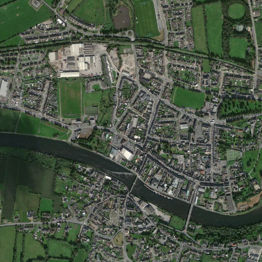
9.2 Parking Strategy and Impacts
On-street parking provision on Main Street is proposed to be reduced as part of the regeneration scheme. This
reduction in on-street car parking is considered acceptable due to the large number of available car parking spaces
within a five minute walk of Main Street. Disabled parking and loading bays will be retained to ensure that access
is maintained to Main Street.
Parking surveys were carried out in 2013 as part of the Carrick-on-Suir Town Development Plan and in 2017, as
part of the Seán Kelly Square Part 8 Planning Application. These were reviewed in preparation for this Traffic and
Parking Impact Assessment. While there are differences between the two survey sets, broadly the overall parking
use in Carrick-on-Suir remained the same. Both sets of parking surveys were carried out in July, with the 2017
study providing data from a weekday (Wednesday) and a weekend day (Saturday).
Parking surveys were not undertaken in 2021 as part of this Traffic and Parking Impact Assessment due to the
restrictions in place on retail, hospitality, work, and schools during the Covid-19 health emergency.
The average space capacity of car parking spaces in the town was 392, out of a total of 696 (56%). Of these
available 392 car parking spaces, 291 (42% of all parking spaces) are within a five-minute walk of Main Street.
21906_6009 13 July 2021CARRICK-ON-SUIR REGENERATION PLAN
Part 8 Planning Report
New access from N24 to St Nicholas
(not part of this Part 8 application)
Fairgreen
SuperValu St.Nicholas The Pound
Main St
Strand Lane
New Street
10 new spaces
Figure 10.1: Overview of Parking in Carrick-on-Suir
A private car park of 80 spaces can be accessed from Main Street, on its eastern end. The 2013 car parking survey
records an average spare capacity of 33 spaces within this car park.
New Street public car park is accessed from New Street, opposite the Tipperary County Council offices. It has a
capacity of 85 spaces, plus parking for buses. Typically, this car park is busy from mid-morning to early afternoon,
similar to Main Street.
St. Nicholas’ Car Park has been identified as an area of under-utilised car parking within Carrick-on-Suir town
centre, with a capacity of 83 vehicles. It is within a five-minute walking distance (350m) of Main Street, via Chapel
Street. The new access to this car park from the N24, which while not part of this application, will be installed in
advance of the works proposed under this Part 8. This new access will be signposted to attract vehicles to this
car park that would otherwise be parking on Main Street.
Strand Lane will maintain its existing 23 car parking spaces, two of which will be for electric vehicle charging. The
car park will be included in the public realm upgrades, with new surfaces and an improved linkage to Main Street
via Oven Lane. Oven Lane (between Main Street and Strand Lane car park) will also be subject to public realm
improvements, including lighting which will improve pedestrian comfort while walking between the two.
Between Strand Lane car park and the Quays 10 no. new car parking spaces will be provided. These will serve
Main Street, but will also provide future parking for activities and places on the Quays. The demolition of the
derelict building on Strand Lane facilitates the creation of these new parking spaces.
The car parking capacity at Sean Healy Park will significantly increase, providing vehicle accessibility to the amenity
area of Sean Healy Park and the Suir Blueway. This car park is just outside the 5 minute walking boundary from
the centre of Main Street.
21906_6009 14 July 2021CARRICK-ON-SUIR REGENERATION PLAN
Part 8 Planning Report
Table 10.2 Proposed Changes to Car Parking
Location Existing no. of spaces Proposed no. of spaces Net change no. of spaces
Main Street 67 25 -42
Oven Lane 23 33 +10
Sean Healy Park 3 39 +36
Total 93 97 +4
The assessment of parking capacity within Carrick-on-Suir confirms that the changes to the parking proposed in
the Carrick-on-Suir Regeneration Project will not result in an overall negative impact on the availability of car
parking within a five minute walk of Main Street, Carrick-on-Suir.
9.3 Review Bus Parking Zones
The proposals do not include any changes to bus stop locations. New Street car park has parking for buses.
9.4 Crossing Details
The traffic on the Main Street will be significantly calmed under the proposed scheme, with reduction to one lane,
tighter lane widths, a series of raised tables and lateral deflections in the road alignment. This will make it much
easier for pedestrians to cross the street in between designated crossing points. There will also be three
controlled crossing points on Main Street. Bridge Street, Chapel Street and Strand Lane, Westgate and Oven Lane
will have shared surfaces to create traffic calmed zones. This will also apply to the section of North Quay between
Old Bridge and Dillon Bridge. North Quay, west of Old Bridge will have a series of buildouts on the south side of
the road to create additional space for pedestrians and to calm traffic.
9.5 Junction Strategy
It is proposed to provide a priority junction at Main Street / Castle Lane / Dillon Bridge, which is currently a traffic
signal-controlled junction. This junction is the entrance into the public realm of Main Street and the intention is
to provide a traffic calmed environment, with priority for pedestrians. The proposed priority junction will operate
with Castle Lane as the main arm, with priority. Traffic will travel straight ahead to Main Street or turn left onto
Dillon Bridge. On Castle Lane, the existing two-lane approach will be reduced to one. Vehicles approaching Carrick-
on-Suir on Dillon Bridge will be required to Stop at the junction and wait for a gap in the traffic to proceed onto
Main Street, which is one-way westbound.
The proposed Main Street / Castle Lane / Dillon Bridge priority junction has been analysed using the computer
software programme, TRL JUNCTIONS PICADY for priority controlled junctions, for the predicted 2023 opening
year and 2028 and 2038 plan years. The junction capacity analysis of the existing traffic signal junction and
proposed priority junction indicate that the junction will continue to operate within capacity in the opening year
2023 and plan years 2028 and 2038.
The proposed priority junction performs better than the existing traffic signal layout in the opening year 2023 AM
peak on the Castle Lane approach with reduced queueing lengths and times. The AM peak on the approach from
21906_6009 15 July 2021CARRICK-ON-SUIR REGENERATION PLAN
Part 8 Planning Report
Dillon Bridge to Main Street has relatively imperceptible differences while the proposed priority junction performs
better than the existing traffic signal layout during the inter-peak period. This period is more closely
representative of the majority of the day outside of the peak times in Carrick-on-Suir, and includes retail and
hospitality opening hours. This will bring significant improvements to Main Street with regards to the public realm
upgrade, reducing queuing traffic on the approach to town. Pedestrians will be able to cross in between gaps and
when vehicles stop for them, reducing pedestrian wait times, compared to the traffic signal junction layout.
If the third crossing for Carrick-on-Suir proceeds to be planned and constructed, it will significantly reduce traffic
travelling onto Main Street from Dillon Bridge, reducing forecast queuing and delays.
A proposed reduction in on-street parking and an improved public realm for pedestrians will also encourage more
trips to Main Street by walking, further reducing the traffic volumes over time in the town centre.
10. Archaeological Assessment
An Archaeological Assessment was undertaken for the proposed Regeneration Project at Carrick-on-Suir. A copy
of the report is included in Appendix E. It is noted in the report that the majority of the proposed works are within
the Zone of Archaeological Notification/Potential (ZAP) for the historic town of Carrick-on-Suir. Within the historic
town there are 33 known sites or monuments of archaeological significance, including the complex of medieval
and post-medieval castle building at Ormond Castle. Also, the subsurface line of Carrick-on-Suir’s Town Defences
traverses the streetscape in several locations throughout the historic core of the town and the improvement
works have potential to interact with the defences, as presented in drawing “05 Potential Areas of Interaction
with Town Defences” included in Appendix E.
An evaluation of the potential impacts of the proposed project on the archaeological resource was undertaken.
The report recognises that the proposed Carrick-on-Suir regeneration project will enhance access and
presentation of the medieval core of Carrick-on-Suir as a living, social and commercial place which will be
supported by a plan that encourages pedestrian movements, and car-parking at locations outside of the medieval
core.
It is noted that the ground disturbance required to undertake the works, has the potential, if unmitigated, to
negatively impact on the archaeological resource of the town. The report recommends that all ground
disturbances should be archaeologically monitored, by a suitably experienced archaeologist. It is further
recommended that advanced targeted test trenching for the town defenses should be considered to assess the
potential presence of town wall fabric, as this would de-risk any impacts and delays to construction.
11. Architectural Assessment
An Architectural Heritage Impact Assessment (AHIA) was undertaken for the proposed Regeneration Project at
Carrick-on-Suir. A copy of the report is included in Appendix F.
The AHIA assessed the physical and visual impacts of the proposed works and highlighted the materials which are
to be retained. Overall, the AHIA concluded that the proposed regeneration works will result in positive visual
impacts on the setting of the historic buildings. The AHIA recommended the following:
• West Gate – it is recommended to retain and re-use the section of surviving historic limestone kerbing.
• Quays and Laneways - care should be taken on removal of existing surfaces on the laneways and any
earlier elements below recorded and/or brought to the attention of the supervising archaeologist.
21906_6009 16 July 2021CARRICK-ON-SUIR REGENERATION PLAN
Part 8 Planning Report
Historic buildings, walls, gateways and doorways open directly on to these lanes and should not be
damaged during the course of laying new laneway surfaces.
• Main St. – care must be taken to protect the surviving architectural elements of interest such as
limestone or terrazzo thresholds, the base of historic shopfronts and decorative service covers during
the course of the works, and to retain and reuse items set in the pavements.
These recommendations will be considered in the detailed design phase and construction phase of the Carrick-
on-Suir Regeneration Plan.
In addition to the above the AHIA report also advises in the listed mitigation measures that archaeologically
sensitive areas such as the Tholsel/ClockTower may require monitoring; Existing basements and coal cellars are
to be considered in the placement of new seating; and coloured asphalt should be chosen to minimise visual
impact on the streetscape and individual buildings.
12. Design Standards
The scheme was designed in accordance with the various publications as listed:
National Cycle Manual (NCM), 2007, National Transport Authority. https://www.cyclemanual.ie/
Design Manual for Urban Roads and Streets (DMURS) Version 1.1, 2019, Government of
Ireland. https://www.dmurs.ie/
Traffic Management Guidelines, 2003, Department of Transport, Government of Ireland.
Traffic Signs Manual, Chapter 7 Road Markings, 2019, Department of Transport,
Government of Ireland.
Design Manual for Bicycle Traffic, 2016, CROW.
Cycle Infrastructure Design, Local Transport Note 1/20, July 2020, UK Department for
Transport.
TII Publications (Standards), Transport Infrastructure Ireland. https://www.tiipublications.ie/
TII Publications (Technical), Transport Infrastructure Ireland. https://www.tiipublications.ie/
DN-PAV-03021 Pavement and Foundation Design.
DN-PAV-03024 Bituminous Mixtures, Surface Treatments, and Miscellaneous Products and Processes
DETR Guidance on the use of Tactile Paving surfaces
http://universaldesign.ie
Natural Stone Surfacing – Good Practice Guide
Guideline for Managing Openings in Public Roads
Basis of Design: IS EN 1990: Eurocode – Basis of structural design. (EC0)
21906_6009 17 July 2021CARRICK-ON-SUIR REGENERATION PLAN
Part 8 Planning Report
General Actions: IS EN 1991: Eurocode 1: Actions on structures. (EC1)
Design of concrete: IS EN 1992: Eurocode 2: Design of concrete structures. (EC2)
Design of steel: IS EN 1993: Eurocode 3: Design of steel structure. (EC3)
Design of timber: IS EN 1995: Eurocode 5: Design of Timber structures. (EC5)
Design of masonry: IS EN 1996: Eurocode 6: Design of masonry structures. (EC6)
Geotechnical: IS EN 1997: Eurocode 7: Geotechnical design. (EC7)
Building Regulations of Republic of Ireland
Wastewater: IS EN 12056 Gravity drainage systems inside buildings
Sewer Foul and Storm: IS EN 752:2008 (Drain and sewer systems outside buildings) and the Sewers for adoption
7th Edition.
SUDS: Ciria (C753) SuDS manual
Rainfall data: Met Eireann
Code of Practice for Water Infrastructure Connections and Developer Services; Design and Construction
Requirements for Self-Lay Developments; July 2020 (Revision 2) https://www.water.ie/
Water Infrastructure Standard Details Connections and Developer Services; Construction Requirements for Self‐
Lay Developments; July 2020 (Revision 4) https://www.water.ie/
Code of Practice for Wastewater Infrastructure Connections and Developer Services Design and Construction
Requirements for Self-Lay Developments July 2020 (Revision 2) https://www.water.ie/
Wastewater Infrastructure Standard Details Connections and Developer Services Design and Construction
Requirements for Self‐Lay Developments July 2020 (Revision 4) https://www.water.ie/
The electrical installation shall be in accordance with the following:
Complying with Irish Standard I.S. 10101: 2020 ‘National Rules for Electrical Installations’ Edition 5.0;
Complying with ET 206:2009, ET213:2007 and subsequent addendums;
Guidelines on Selection of Lighting Classes PD CEN/TR 13201-1:2014
Road Lighting Performance Requirements IS EN 13201-2: 2015
Code of practice for the design of road lighting. Lighting of roads and public amenity areas BS 5489-1:2020 and
subsequent addenda
Current ESB Networks Regulations, Codes of Practice and Guidelines including the latest edition of the ESB
National Code of Practice for Customer Interface and ESB requirements for Works on Public Lighting on ESB’s
Networks;
Current edition of ESB Requirements for Work on Public Lighting on ESB’s Networks;
Complying with ESB Networks Ltd. Contractor Pack for Working Near Live Overhead or Underground Cables and
subsequent addenda;
21906_6009 18 July 2021CARRICK-ON-SUIR REGENERATION PLAN
Part 8 Planning Report
Complying with ILP Code of Practice for Electrical Safety in Highway Electrical Operations and subsequent
addenda;
ESB Networks Procedure Public Lighting Work Activities (PLWA);
Tipperary County Council Public Lighting Policy
13. DMURS Statement
The objective of “The Design Manual for Urban Roads and Streets” (DMURS) is to achieve better street design in
urban areas. This will encourage more people to choose to walk, cycle or use public transport by making the
experience safer and more pleasant. The proposed layout for Carrick-on-Suir Regeneration promotes and
prioritises walking and cycling.
13.1 Main Street
The traffic on the Main Street will be significantly calmed under the proposed scheme, with reduction to one lane,
tighter lane widths, a series of raised tables, controlled crossing points and lateral deflections in the road
alignment. This will make it much easier for pedestrians to cross the street in between designated crossing points.
13.2 Laneways and Side Streets
Shared surfaces are proposed for Main St., Bridge Street, Chapel Street, Strand Lane, Westgate, Oven Lane and
to the section of North Quay between Old Bridge and Dillon Bridge to create traffic calmed zones.
The Design Manual for Urban Roads and Streets (DMURS), Department of Transport, Tourism & Sport (March
2013), defines shared surface streets and junctions as: ‘Integrated spaces where pedestrians, cyclists and vehicles
share the main carriageway. This may include streets where the entire street reserve is shared or where
designated sections may provide for pedestrians and/or cyclists use only with a shared surface carriageway along
part of the street.
The key condition for the design of any shared surface is that drivers, upon entering the street, recognise that
they are in a shared space and react by driving very slowly (i.e. 20km/h or less). To ensure this, designers should:
• Use a variety of materials and finishes that indicate that the carriageway is an extension of the pedestrian
domain.
• Avoid raised kerb lines. Any kerb line should be fully embedded within the street surface.
• Minimise the width of the vehicular carriageway and/or corner radii.
Consequently, these principles have been adopted for Carrick-on-Suir Regeneration, where flushed kerbs and
high quality surface materials will be used to areas of shared surface to encourage the movement of pedestrians
across the spaces and to alert drivers that they are passing through a pedestrian priority area. The shared surface
treatment is intended to calm traffic movements, while reinforcing pedestrian activities and enhancing visual
amenity, economic performance and perceptions of personal safety.
The upgrade of Chapel St., Oven Lane and Strand Lane makes parking in the existing car parks more attractive by
providing a pleasant walking route to the Main St.
21906_6009 19 July 2021CARRICK-ON-SUIR REGENERATION PLAN
Part 8 Planning Report
13.3 North Quay
The Suir Blueway route is continued along the Quays to encourage cyclists to explore the town of Carrick-on-Suir.
North Quay, west of Old Bridge will have a series of buildouts on the south side of the road to create additional
space for pedestrians and to calm traffic. The proposed build outs will be used as a series of Traffic Give Way
passing bays, with traffic travelling West giving priority to travelling East. A shared surface is provided between
Old Bridge and Dillon Bridge. As outlined above proposed shared surfaces are designed so that the drivers
entering a shared space zone recognises the zoned area and reacts by driving very slowly (i.e. 20km/h or less).
This will provide a safer and more pleasant experience for those enjoying the Quays.
14. Utilities Impacted by the Scheme
Services enquiries were issued to the utility providers in January 2021 requesting a copy of their records of
services within the proposed project area. In addition to the services enquiries to the utility providers, a
Topographical Survey was undertaken in March 2021 and a Ground Penetrating Radar (GPR) survey was
undertaken in April 2021. This information was used to assess the existing utilities in comparison with the
proposed design and to identify any potential clashes which may require diversion of utilities.
14.1 ESB
The project brief requests for the undergrounding of all overhead electrical cables. All electrical cables on Main
St. currently run underground.
On the Southern side of Main St., there are some overground cables running along the Quays west of Old Bridge
and running across Old Bridge as well as along Strand Lane, Oven Lane and Hotel Lane. An overhead line crosses
Castle Lane at the entrance to Pill Lane. Overhead lines also occur on the Northern side of Main St. running along
Chapel St., Ball Alley Lane and to the west of Main St. on Greystone St. As part of the public realm upgrade works,
it is proposed to liaise with ESB Networks and underground the existing overhead ESB cables.
It is proposed to install 2 No. electric vehicle charging points and all associated ducting infrastructure in the Car
Parking to comply with the new electrical wiring regulations IS10101 and in accordance with the EU Regulations
2018 (SI No. 414 of 2018). As part of the detailed design drawings, ducting infrastructure shall be included for
future EV charging points in the town.
Depending on the depth of the underground MV electrical cables running along Main St. and Bridge St. and on
the Quays at Old Bridge, electrical cables may need to be lowered to accommodate a concrete slab underneath
shared surface areas.
14.2 Gas
Low pressure Gas line runs the length of Main St. and branches to the south running down the length of Bridge
St. and branching into Hotel Lane. A low pressure gas pipe runs Northward along Chapel St., turning into Ball Alley
Lane and runs northward into Stable Lane and New St. The low pressure gas line also runs for a short distance
along the Quays west of Old Bridge. A medium pressure Gas line turns down onto Barrack Lane from Dillon Bridge
overhead and runs east along the Quays, northwards up Castle Lane and enters Castle St.
Depending on the depth of the gas line, the line may need to be lowered to accommodate a concrete slab
underneath shared surface areas.
21906_6009 20 July 2021You can also read