Stratford-upon-Avon Waterfront Masterplan - Dec 2003
←
→
Page content transcription
If your browser does not render page correctly, please read the page content below
Stratford-upon-Avon Waterfront
Masterplan
Stratford-upon-Avon Waterfront
                   Masterplan

           ROGER EVANS ASSOCIATES

June Tandy
Stratford-upon-Avon and its rich cultural heritage is the jewel of the Midlands, attracting millions
of visitors a year. It directly benefits the economy of Warwickshire and the region, and is of
international significance. We are charged with the duty of ensuring that the offer to both visitors
and residents is of the highest quality. The proposed redevelopment of the Royal Shakespeare
Company’s theatre holdings in Stratford offers us a once-in-a-generation opportunity to evaluate
the public realm closely associated with the theatre area, identify areas for improvement and to
bring forward new initiatives for the benefit of the Town.
A new bridge, pedestrian priority areas and river walkways are all part of the Stratford Waterfront
Masterplan, together with many key elements of the wider Stratford Transport Strategy. I am
delighted that we now have a blueprint for the town’s river corridor and look forward to its
implementation in the years to come.

June Tandy
Deputy Leader and Cabinet Member for Regeneration and Planning
Warwickshire County Council

Richard Adams
The Waterfront is at the heart of the town. Here the countryside meets the historic centre of the
town. Seemingly the character of the area has not changed but the pressures have. More than
two and a half million people visit the town each year, traffic levels continue to increase and the
town needs to respond to pressures for change to remain a successful and vibrant centre.
The County Council and the District Council have responded to these pressures by working in
partnership with the public and all the key bodies in the town and the region to prepare a vision
for the future. It has taken us a great deal of work and the advice and participation of a wide
range of people. We have listened to the comments made and we have changed our proposals
to incorporate the best ideas.
Our vision is simple. We seek to create a world class environment for the Waterfront area in
Stratford-upon-Avon that will complement the whole of the town. The Masterplan provides the
framework to achieve that vision.

Councillor Richard Adams
Planning & Transport Portfolio-holder
Stratford-on-Avon District Council
Contents
Background                      1    Most House Hotel                         41
                                     North Riverside Walk                     41
Aims                            3    Cattle Market Green                      42
                                     Marina                                   42
Issues and Considerations       4    Tourist Information Centre               43
                                     Pen and Parchment & adjacent building    43
Assets                          6
                                     The Recreational Ground
                                         Recreation Ground                   4040
The Design Approach             7
                                     Area
                                     A    and town wide measures              43
The Masterplan                  10
                                     References                               51
Masterplan Proposals            15
Heart of the Waterfront         17
Bancroft Gardens                18
Bridgefoot                      21
Royal Shakespeare Theatre       23
          Recreation Ground
The North Recreational Ground   24
N footbridge
New                             28

The Waterside                   29
Waterside and Southern Lane     30
Royal Shakespeare Gardens       33

Bridgeway                       35
The Avenue                      37
Riverside car park              38
Leisure Centre                  39
Unicorn Meadow                  40
Harlequin Public House          40
Background
1.1 The work contained in this document                      further early steps include the Riverside
    represents a stage in a process. A great deal            Environs Study, undertaken for Stratford-on-
    of work has been done prior to the beginning             Avon District Council (SDC), and the parallel
    of the Stratford Waterfront Area Masterplan              RSC Stratford Redevelopment and Stratford
    project and the results, included in this report,        Theatre Area Feasibility Studies, undertaken
    should be the starting point for still more. It          for the RSC and SDC with Warwickshire
    is also the case that the Masterplan project             County Council (WCC) respectively.
    is part of a larger effort involving Stratford-
                                                        1.3 The Riverside Environs Study (RES) provided
    on-Avon District Council, Warwickshire
                                                            an overall vision for the Riverside area and
    County Council, the Royal Shakespeare
                                                            included a comprehensive set of proposals
    Company, the Arts Council and Advantage
                                                            to achieve that vision. The Stratford Theatre
    West Midlands. The broad aim of that effort
                                                            Area Feasibility Study (STAFS) was a
    is to effect an overall social and economic
                                                            refinement of the RES, examining selected
    enhancement of the West Midlands region,
                                                            areas in more detail. It involved production
    South Warwickshire and the town of Stratford-
                                                            of urban design and landscape proposals
    upon-Avon through a comprehensive range
                                                            to be co-ordinated with work by the RSC,
    of physical improvements to the town and
                                                            considering both the cost estimates of, and
    elements within it, in particular the RSC
                                                            public response to, particular proposals. A
    theatres.
                                                            stakeholder workshop held at the end of
1.2 Needless to say, the process involved                   the study resulted in a broad consensus
    is a long one. Essentially beginning                    regarding particular proposals and priorities.
    with the preliminary feasibility studies
    for redevelopment initiated by the Royal
    Shakespeare Company (RSC) in 1996, the

                                                                                                             1
2

Stratford-upon-Avon waterfront
Aims
2.1 The aim of the Masterplan, as set out in the       2.3 As the third step in a sequence of studies, the
    project brief, is to produce a design-led vision       scope of the Masterplan is more limited than
    for the future of the Waterfront public realm          its precursors. It takes as a starting point the
    area at Stratford-upon-Avon, seen in the               significant amount of work that has already
    context of proposals which are anticipated             been done. The background and baseline
    in relation to the redevelopment of the Royal          information contained in the RES and STAFS
    Shakespeare Theatre.                                   provides the foundation for the Masterplan
2.2 To achieve that aim, the Masterplan seeks              and is not repeated here.
    to refine and consolidate the results of the       2.4 The Masterplan provides a vision for
    preparatory studies (RES and STAFS).                   the whole Waterfront area, illustrated by
    That being so, the core objectives of the              schematic or diagrammatic designs. Those
    Masterplan are those of the STAFS, namely,             designs should be interpreted not as specific
    to:                                                    solutions but statements of design principles.
     •   create a world class public realm, which      2.5 One of the principal purposes of the images
         complements the proposed development              and descriptions is to provide guidance for
         of the RSC’s theatre and land holdings,           the preparation of detailed schemes and
     •   accommodate the needs of those who                to assist fund-raising efforts. The District
         use the area and travel through it,               Council has adopted the Masterplan as
                                                           supplementary planning guidance and
     •   improve the character and quality of the
                                                           the document is a material planning
         physical environment.
                                                           consideration that will be taken into account

                                                                                                              Aims
                                                           in dealing with future planning applications.

                                                                                                                                               3
Issues and Considerations
    3.1 The two previous studies reached a                         favours motorists at the expense of those
        significant degree of consensus in identifying             on foot and through traffic rather than
        the issues and considerations to be faced in               local movements.
        making improvements to the Waterfront area.            •   The cumulative effect of these problems
    3.2 The core issues cited in the RES are clearly               is to degrade some quite exceptional
        still core issues.                                         public spaces, detract from the
                                                                   architectural quality of the town, reduce
         •   In common with many other market towns
                                                                   the quality of experience for visitors,
             today, there is a constant struggle to
                                                                   potentially threaten the long term local
             maintain pedestrian comfort, and hence
                                                                   economy and, not least, make the
             the experience of the town, due to the
                                                                   town less pleasant for residents who
             increasing intrusion of vehicular traffic.
                                                                   increasingly find themselves literally
         •   The volume of tourists who come to see                competing for space.
             and walk around Stratford exacerbates
             the already cramped conditions for           3.3 More specific issues identified in the RES
             pedestrians in some areas. The fact              include:
             that visitors are largely restricted to a         •   narrow pavements,
             few areas by natural and built features           •   poor quality environment due to noise,
             further increases the load on riverside               fumes and safety hazards,
             areas, which by their nature are fragile
             landscapes.                                       •   poor facilities and remoteness of railway
                                                                   station,
         •   The growth of the town in the north east
             quarter, bounded by Warwick Road and              •   unattractive pedestrian route from railway
             Bridgefoot, has occurred in a way which               station,

4
Stratford-upon-Avon waterfront
                                                                                                                                                          Issues and considerations
•   lack of central bus station,                3.4 The STAFS identified the following issues:        3.5 Given the area in question is a river
•   poor bus waiting facilities,                     •   pedestrian congestion,                           ‘waterfront’, a fundamental constraint that
                                                                                                          cannot be overlooked is that the greater part
•   parking of coaches in unauthorised areas,        •   vehicle dominance over pedestrians,              of the site lies within a flood plain.
•   traffic congestion due to coaches,               •   inadequate pedestrian path network,
                                                                                                      3.6 A further fundamental issue in seeking
•   poor provision for cyclists,                     •   confused/obscure pedestrian links                to achieve the aims of a Masterplan that
•   poorly defined pedestrian route from the             between activity areas,                          covers a large area is the need to consider
    Royal Shakespeare Theatre (RST) to Holy          •   poor provision for cyclists,                     the needs and aspirations of a number of
    Trinity Church,                                                                                       different property holders.
                                                     •   inadequate signage/information,
•   poor pedestrian accessibility between                                                             3.7 These are, in summary, the principal issues,
                                                     •   traffic conflicts at gyratory,
    Bridgefoot and Bancroft,                                                                              considerations and significant constraints
                                                     •   difficult junction at Swan’s Nest Lane,          that have been addressed in formulating the
•   low quality route down Bridgeway,
                                                     •   confused bus facilities,                         Masterplan proposals.
•   car domination of Bridgeway/Bridgefoot,
                                                     •   intrusive on-street parking,
•   confused area around Tourist Information
    Centre,                                          •   lack of identity and poor use of space at
                                                         Bridgeway,
•   cluttered/obscured view from Bridgefoot
    to RST,                                          •   confused and poorly organised
                                                         landscape areas at North Recreation
•   difficult pedestrian crossings at Swan’s             Ground,
    Nest Lane/Clopton Bridge approach.
                                                     •   poor quality materials in many areas,
                                                     •   lack of co-ordination in materials, street
                                                         furniture and lighting.

                                                                                                                                                                                           5
Assets
4.1 The two studies also identified significant • Waterside promenade, 4.2 All these represent, in the terms of the brief,
assets within the waterfront area: • defined built edge along Waterside, ‘sensitive areas and features’, that, amongst
• the river, others, have been addressed in formulating
• the RSC Gardens, the Masterplan proposals.
• the continuity of green space along the • rural, secluded character of Southern
river, Lane,
• water-based activities (Marina, Boat • Holy Trinity Church,
House, Boat Club, rental boats and trips),
• mature grounds of Alveston Manor,
• natural areas of the Warwick Road Lands,
• traffic island with trees and pavilion,
• Clopton and Tramway bridges,
• the openness and greenness of the Rec.,
• the Toll House and Cox’s Yard,
• areas for informal activity,
• the Bancroft,
• views to Holy Trinity Church, to the
• the Gower Memorial, theatre, to the bridges,
• the canal basin and lock, • opportunities for longer riverside walks,
• gradient of activity and distinct character • the Onion Fields,
areas, from urban to rural:
• numerous mature trees throughout the
west bank: the Bancroft, the RSC area,
Gardens, the Dell, Holy Trinity Church,
• numerous listed and other historic
east bank: Swan’s Nest Lane, the North buildings throughout the area.
Rec. the South Rec, Rushbrook,
• the RST,
6Stratford-upon-Avon waterfront
The Design Approach: Guiding Principles
5.1 It is conventional in architectural and approach. A town is not big architecture. 5.4 The other way to see the idea of a town
landscape architectural design to identify a The nature of an individual building and a is in the specific sense of working in, and
concept in producing a design. The concept, town is fundamentally different, and in a on, an existing town. What is its particular
often an abstract simile or metaphor, defines variety of ways. Perhaps most centrally, history and character? What are its positive
an internal logic that acts as a basis for a town is the seat of a civic group or features? Like many towns, Stratford’s
making design decisions. The purpose community, not an individual or private history and character are complex.
of the concept is to aid in achieving a corporate body. A town is a structured
5.5 With that as a basis, the concept used in
coherent and integrated design, a design combination of public and private space.
generating the Masterplan for the Stratford-
Guiding principles
that holds together with a clear character
5.2 This is not to argue that a masterplan should upon-Avon Waterfront has two principal
and identity. With a primarily metaphorical or
not have a guiding concept. It is to argue dimensions, one general, the other specific.
associative approach, the concept such as,
that, when working on a town, a preferable The first can be summarised in the idea of
‘sailboats on the bay’, is not directly related
guiding concept would not be associative or civic space. What is at the root of civic space
to the task of building. The metaphor is,
metaphoric but the idea of a town. and how can a design help to allow and
in a sense, extraneous or tangential to the
encourage civic life to happen? The second
thing to be designed. This approach can 5.3 Starting from the idea of a town, there are two
is the idea of Stratford-upon-Avon. How
produce exceptional and impressive results, ways of making use of the concept. One is
can the Masterplan draw out the positive
the Sydney Opera House, for example, or to see the idea in a general sense. What is
characteristics of the town? How can it make
the Guggenheim Museum in Bilbao. It is a town for? What are the features of a good
the most of the town’s assets, enhance and
notable, however, that these two examples town? Towns have many different reasons
reinforce its positive characteristics and
are individual, free standing buildings. for being and carry a variety of meanings for
ameliorate the conflicts and problems?
Confronted with the task of creating a design different people. The idea of a town is thus
or Masterplan for a town, or part of a town, not likely to be singular or simplistic.
care should be taken when applying this
75.6 The vision for the Waterfront embodied in the Design for the future
Masterplan should thus seek to make the 5.9 New development should not be seen
Waterfront an identifiable public place that as a solution to a short-term need but
is inextricably connected to the town as a as a resource for the long-term life of
whole. The Waterfront should have its own the community. To achieve this, new
identity but one that is central to the identity development should:
of the town. At the same time, the various
• minimise energy and resource use over
different areas within the Waterfront should
the life of the development,
retain their distinct character.
• reuse and/or minimise changes to
5.7 In seeking to achieve that vision, the original existing built and landscape features,
objectives of the Masterplan, of course, still
apply as set out at 3.2 above. • use local materials where possible,
• use materials and designs that take less
5.8 The following points provide a more specific
energy to make and to use,
articulation of the basic approach taken in
formulating the Masterplan. • promote walking, cycling and an efficient
public transport system,
• allow for alteration and extension of
buildings with little trouble.
8Stratford-upon-Avon waterfront
Design with nature and the locality Create neighbourhoods Create a clearly defined and legible public
5.10 Rather than erasing what exists, new 5.11 To avoid creating fragmented and isolated realm
development should make the best of the places, new development should work on the 5.12 To avoid creating homogeneous and
natural and built resources on and around basis of the neighbourhood. Development disorienting places, new development should
the site and the cultural traditions of the area. should help to create or contribute to the seek to create a well articulated environment
It should retain the distinctiveness of the sense of a whole that has a centre, both that is easy to navigate. New development
locality. New development should, therefore: physical and social. To achieve this, new should, therefore:
• protect and enhance important or development should: • create an interconnected network of
Guiding principles
sensitive landscapes and habitats, • create a distinct physical centre with streets and public spaces,
• highlight key landscape and townscape routes leading directly to it, • create a visual hierarchy of streets with
features, • have a range of facilities in the centre different character,
• minimise changes to topography and surrounded by residential areas, • create well defined streets and spaces,
drainage patterns, • ensure the centre is within easy walking • clearly distinguish public and private
• retain and incorporate as much existing distance, space,
planting and habitat as possible, • ensure the centre is accessible to the full • incorporate and highlight views to
• reuse or adapt existing routes, range of people in the area. surrounding landmarks,
boundaries and buildings, • create landmarks and views to them,
• follow patterns of settlement and building • emphasise focal or nodal points with
typical of the region. public space or landmarks.
9The Masterplan
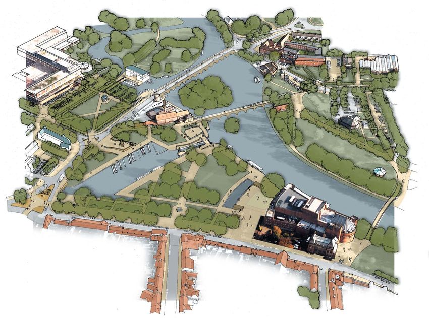
The Waterfront as a whole within the town the town edge should not be seen as solid 6.5 The Masterplan therefore identifies four
6.1 For a Masterplan to be effective, the but crucially connected to the centre by the sub-areas that form the basis for action. As
‘Waterfront’ should a clearly identifiable entity. routes running perpendicular to the river, illustrated in Figure 1, these are:
People should not have trouble saying where namely Guild Street, Bridge Street, Sheep • The Heart of the Waterfront,
and what it is. The boundaries should be Street, Chapel Lane, Old Town and Sanctus
Street. • The Waterside,
evident: that is, correspond to features on
the ground. The Masterplan should clearly • The Avenue,
6.3 The boundaries to the north and south are
identify the area to be planned and its relation necessarily more arbitrary. To the south, • The Recreation Ground.
to the town as a whole (see Figure 1). Seven Meadows Road forms a convenient 6.6 The Masterplan should aim to both bind
6.2 The outline of the Waterfront area is identified end point but there is continuity of the these areas together into a whole and
in the brief for the Masterplan study. ‘waterfront’ in a generic sense and in the enhance their individual identities. A key
Looking more generally, the boundaries specific overlap of agricultural land (the means of drawing the areas together is to
can be identified in terms of the relation Onion Fields and the rest of Cross-o-the-Hill focus on the patterns of movement through
of the area to the centre of town and Farm). To the north, the boundary might have them and the structure of the landscape that
surrounding development. The Waterfront been set further up at the Fisherman’s Car runs over the entire area and the built form
lies within the flood-plain of the river and Park or further still given the continuity of the that defines public spaces (see Figures 2, 3
sits at the edge of the historic town, with character of the flood plain. and 4).
building on the town edge predominantly
The characteristics of the Waterfront 6.7 In response to the issues identified in the
fronting onto the Waterfront. Main routes
6.4 Any examination of the area shows that the various appraisals done in this and previous
into town parallel the line of the river to the
Waterfront is not uniform. It has distinct areas studies, the recommended strategy for
north-west, north-east and south-east, the
within it, differences that give it its particular binding the areas together into a whole
Warwick, Tiddington and Shipston Roads
character. The Masterplan should articulate includes the following:
respectively. Later development along
and reinforce those differences and at the
these routes predominantly backs onto the
same time ensure they work together to form
Waterfront. The east and west boundaries
a coherent whole.
are therefore fairly easy to identify. That said,
10Stratford-upon-Avon waterfront
General
• make minimal changes to achieve
maximum benefit,
• highlight and make the best of existing
features,
• enhance existing character,
• establish a co-ordinated strategy for re-
paving hard-surfaced areas as part of the
overall improvements to the Waterfront
area,
The masterplan
• use a simple palette of high quality
materials starting from the example of
Lower Henley Street (York stone slabs
and setts, granite kerbs and tegula
blocks),
The Avenue
• establish a co-ordinated strategy for
street furniture as part of the overall
The Heart of the
improvements to the Waterfront area, Waterfront
• establish a visitor management strategy
The Waterside
for the Waterfront,
• enhance the distinct but interrelated areas The Recreation
within the Waterfront area; Ground
Figure 1: Masterplan key diagram.
Numbers relate to sections in the
report
11Movement
• conceive of the area as primarily for the • improve the continuity of the riverside
benefit of those on foot rather than for walk along the west bank of the river,
vehicular traffic - ‘make the traffic fit the
• create a circular route binding together
town not the town fit the traffic’,
the Bancroft and North Rec.,
• increase areas of footways and cater to
• reinforce and extend pedestrian routes
pedestrian desire lines,
outward to the main areas;
• integrate Bridgeway into the town as a
street,
• disperse traffic and take it out of the
gyratory system,
• increase visual cues that indicate
Bridgeway is ‘in’ the town and not merely
a channel for vehicles,
Add connection
Add or alter
Reinforce route route
Controlled
Existing route
vehicle access
Node Pedestrian
priority
Key building Existing route
Figure 2: Pedestrian movement Figure 3: Vehicular movement
12Stratford-upon-Avon waterfront
The masterplan
13Landscape
• enhance the continuity of the wider
waterfront area as a green corridor,
• clarify movement structure and visually
emphasise main routes and principal side
routes extending from them with both
surface treatment and planting,
• use simple detailing for streets and public
spaces;
Built form
• use development opportunities where
possible to reinforce the definition,
character and activity of the public
Proposed tree
spaces (Bridgeway and the Marina), planting
• use development opportunities on local
Amenity grass
authority land to help fund other projects.
Existing tree
planting
Grassland or
arable
Trees to be
removed
Water
Figure 4: Landscape structure
14Masterplan proposals
7.1 In this section the Masterplan proposals
have been broken down into individual
projects and are organized by sub-area.
The proposals are illustrated by a series
of plans and perspectives. The project
descriptions include Project aims, Project
details, an indication of the ownership and/or
control of the relevant land and a list of
related Masterplan projects and the body
responsible.
Figure 5: The waterfront
from the south
1516
The heart of the waterfront
17
Bancroft Gardens
                        7.1.1 Bancroft Gardens
                             The Bancroft Gardens constitute the principal
                             central public space in Stratford. It is very
                             popular and intensively used. In a number of
                             respects it is a successful space but suffers
                             both from its success and from a lack of
                             clarity in design and lines of movement.
                             Significant improvements could be made with
                             a minimum of means.

                             Project aims:
                             • create a simple and elegant public
                                space able to accommodate a range of
                                activities,
                             •   provide a strong relationship and ease of
                                 movement between Bridgeway, Waterside
                                 and the Royal Shakespeare Theatre,
                             •   facilitate access to the river’s edge and a
                                 riverside walk,
                             •   improve the character and quality of the
                                 central public space,
                             •   assist management of the wear and tear
                                 on Bancroft Gardens.

                             Project details:
                             • co-ordinate re-paving of hard-surfaced
                                areas within the Bancroft and within the
                                Waterfront area as a whole,
                             •   co-ordinate street furniture within the
                                 Bancroft and within the Waterfront area as
                                 a whole,
                             •   establish a visitor management strategy
                                 for the Bancroft and riverfront areas,
                             •   consider creating a joint ticketing/
                                 information kiosk for river/canal activities
                                 at Tramway House (e.g. UANT, BWB,
                                 SDC, private operators),
                             •   create distinct but interrelated areas
                                                                                Figure 6: The Bancroft Gardens: perspective, with references to sub-areas
18                               within the gardens;
Central area: A7. create new direct route from canal basin such as central jets or sprays as well as
A1. create new direct routes from Waterside to RST (near Waterside) emphasised by cascades along the retaining wall),
to the water’s edge (one by reflecting line of new trees as a cross axis to main C2. improve and create hard surfaced
pool, one to the canal basin), route from Waterside to the river, spaces and steps either side of pool to
A2. widen main route from Waterside, at A8. consider more formal planting within facilitate movement from Bancroft to RST
fountain, to the basin/lock bridge/river, ‘compartments’ either side of fountain; forecourt;
A3. remove shrub planting near lock bridge,
River’s edge: Canal basin:
A4. create a new space adjacent to the canal B1. widen and redesign surface and edging D1. widen hard-surfaced footpaths around
lock, large enough to accommodate at the river’s edge to allow people to the canal basin,
The heart of the waterfront
performers, as a terminus to main route, ‘touch the Avon’; D2. create new route between trees from
A5. remove two trees (one Lime, one Birch) to Waterside to canal basin stub,
Water feature:
open view to the RST from Bridgefoot,
C1. create a dynamic water feature as a D3. create new route/steps along canal edge
A6. remove foot path to enlarge area of grass mutual focus for the Bancroft and RST down to canal stub from higher hard
(to compensate for reflecting pool and that mediates and brings the two together surfaced area to north-west (by the main
path), (at Bancroft level with retaining wall to canal road bridge),
RST forecourt: consider active features D4. add new tree to replace felled willow;
D4
A1
D3
A8
D1
A2
A8 C2
A3
A7 C1 B1
A5 A4 D2
A6
D1
C2
A1
Figure 7: Bancroft central area; enhance functionality, Figure 8: Water feature: demarcate the change in level and Figure 9: Canal basin: improve pedestrian circulation around the
accessibility and quality relationship between the RST and the Bancroft basin
19Bancroft Gardens
North of the basin: Rose garden:
E1. improve existing steps near canal bridge G1. retain and enhance the Rose garden to
E1 E2. remove sections of low boundary wall provide more comfortable access;
E6 E2
H1 and trees blocking desire line from the Bridgefoot and Tramway:
E3 Bridgeway/Bridgefoot crossing, H1. widen Bridgefoot footway and improve
E3. enhance the setting of the Gower footway surface.
E4
Memorial to provide better access and
E4 E5 visual context, Ownership and control:
The main body of the gardens are owned
E4. create a new stairs, ramp and space
freehold by Stratford-on-Avon District Council
from Bridgefoot to basin overlooking the
but the canal basin and lock are owned by
basin and RST in line with the Bridgefoot
British Waterways. Other interested and
crossing,
responsible bodies include the Environment
G1 E5. remove sections of low wall and trees Agency and The Upper Avon Navigation
F1 from along Tramway and widen access Trust.
points and footpaths,
Figure 10: North of the basin: ease pedestrian linkages between Related projects and responsible body:
Bridgeway and the bancroft and improve the pedestrian E6. replace cherry trees with larger stature
environment around the lock • Bridgeway/Bridgefoot improvements
trees to allow better views;
(WCC, SDC and others),
Lock bridge: • Waterside/Southern Lane improvements
F1. widen the lock footbridge and reduce the (WCC, SDC),
slope to the approach ramps to improve
• redevelopment of the RST (RSC).
access over the canal basin;
20Bridgefoot
The heart of the waterfront
7.1.2 Bridgefoot
Project aims:
• reduce the impact of traffic - speed, visual
intrusion, impediment to pedestrians,
• improve the physical and visual
environment,
• facilitate pedestrian movement,
• create focus and attraction at the bottom
end of Bridgeway, and at Bridge Street
junction, for people arriving in the central
area,
• retain the line of Bridgefoot as a principal
route, actively and visually, into town.
Figure 11: Bridgefoot: perspective
21Bridgefoot
Project details: J6. add trees and create seating/sculpture in Ownership and control:
J1. create new three-way pelican crossing at Bridge Street island, The proposed changes lie within land
Bridgeway (replacing crossing at Cox’s J7. improve surfacing and details, controlled by Warwickshire County Council
Yard) with pedestrian routes following and Stratford-on-Avon District Council.
main desire lines, J8. change surface treatment of carriageway
from Bridgeway junction (extending Related projects and responsible body:
J2. continuity of surfaces from Bridgeway a distance up Bridgeway and toward • improvements to the Bancroft Gardens
across Bridgefoot to make pedestrian Clopton Bridge) to Bridge Street and (SDC, BWB),
movement clearer and easier, around to Waterside) to signal entrance
• improvements to Bridgeway (WCC, SDC),
J3. create focal feature within Bridgeway into town and area of pedestrian priority,
pedestrian reservation, • improvements to the Marina (Stratford
J9. restore Toll House and explore further
Marina, Moat House Hotel, SDC),
J4. realign carriageway to give more space the possibility of a walkway through the
to pedestrians on either side where Toll House and bridge abutments as • new Tourist Information Centre (SDC and
possible, proposed by the RSC to improve the South Warwickshire Tourism),
J5. reduce size of island at Bridge Street and riverside walk. • improvements to Cattle Market Green
redesign to create pedestrian routes that (SDC and Moat House Hotel),
follow desire lines, • improvements to the Pen and Parchment
and adjacent building (Laurel Pub Co.).
J8
J8
J1
J6
J3
J5
J2
J7
J4
Figure 12: Redesigned island at Bridge Street to create a more Figure 13: New pelican crossing at Bridgeway
memorable focal point
22Royal Shakespeare Theatre
7.1.3 Royal Shakespeare Theatre Project details:
Project aims: K1. remove car parking from in front of the
• provide a strong relationship and ease of RST,
movement between Bancroft, Waterside, K2. create new forecourt terrace,
the Royal Shakespeare Theatre and K3. create broad ramp extension to forecourt
beyond to the RSC Gardens, terrace connecting to Waterside to
• improve the character and quality of the accommodate a range of uses including
central public space. disabled access,
K4. promote active use of new terrace area
The heart of the waterfront
(e.g. cafe tables, performances, displays,
etc.),
K5. improve/facilitate access from Bancroft
either side of proposed reflecting pool,
K6. widen access terrace along the riverside
to facilitate pedestrian movement
southwards between river and theatre,
K7. consider illuminating main theatre
K6
K5 building and trees to create a striking
night-time image.
Ownership and control:
K4
The land concerned is owned freehold by the
K2 Royal Shakespeare Company.
K5
K1 Related projects and responsible body:
• Bridgeway/Bridgefoot improvements
K7
(WCC, SDC and others),
• Waterside/Southern Lane improvements
K3 (WCC, SDC),
• North Rec (SDC).
Figure 14: Opportunities to make the RST forecourt a vibrant space linking the theatre and Bancroft Gardens
23The north recreation ground
Figure 15: The North Recreation Ground: perspective
24The heart of the waterfront
7.1.4 The North Recreation Ground
As a whole, the Recreation Ground is greatly Project aims: Project details:
valued as a ‘town park’ and recreational • clarify the overall structure of the area and • co-ordinated re-paving of hard-surfaced
area for both residents and local visitors. It integrate it with adjacent areas, areas both within the North Rec. and as
is also valued as part of an attractive green part of the overall improvements to the
• improve its overall character and quality,
corridor running through the town. It is a flood Waterfront area,
plain and this open characteristic should be • retain the openness of the area for
informal use, • use a simple palette of high quality
protected.
materials,
The North Rec., however, currently suffers • create a complementary attraction to the
Bancroft with a lively atmosphere, • co-ordinated street furniture within the
from a lack of coherence in layout and Bancroft and within the Waterfront area as
usage. Despite its acknowledged value, it • establish a circular route with the a whole,
is not used as well as it might be, given its proposed footbridge/RST/Bancroft
close proximity to the central attractions of Gardens, • establish a visitor management strategy
the Bancroft and RST. The North Rec. thus for the North Rec as part of a broader
• facilitate pedestrian movement from strategy for the Recreation Ground as a
represents a significant opportunity to create South Rec. into town,
a complementary attraction to the Bancroft, whole,
expand the core area and alleviate pressure • improve pedestrian environment around • consider illuminating key buildings and
on the Bancroft. the junction of Swan’s Nest Lane and trees to create a memorable image of this
Clopton Bridge approach and create area;
legible gateway into town.
25The north recreation ground
North Rec Promenade: Parking Lane:
L1. create new ‘square’ bounded by Boat N1. reconfigure access and parking to create
House, Tramway and New Garden with a clear, continuous route,
active edges (e.g. access points), N2. retain and rationalise parking spaces,
L2. widen and resurface the main route from N3. create regular pedestrian routes through
the Boat House, past the restaurant, parking areas,
to the proposed South Rec. Walk/new
footbridge, N4. improve quality and legibility of access
to public conveniences (create a clear
L3. plant large stature trees parallel to ‘front’),
widened route,
N5. clearly identify and screen restaurant
L4. widen/redesign connection with South service area,
Rec. Walk and footbridge to improve
pedestrian access; N6. clearly identify and highlight the ‘front’
(access point) of the restaurant and
associated parking,
L1
L2
N6 N8
N4
L3
N5 N3
N2
N1
N7
L4
Figure 16: North Rec Promenade Figure 17: Parking Lane
26N7. add tree planting (large stature) to identify P4. add tree planting to emphasise line of Ownership and control:
and emphasise main route, Tramway and provide enclosure, The freehold of the Recreation Ground
N8. add tree planting (medium stature) in is owned by Stratford-on-Avon District
Swan’s Nest Lane:
parking areas, Council but the Restaurant and immediately
Q1. realign carriageways either side of
surrounding ground is leased to Patrick Li
N9. allow for coach turning area within gazebo at Clopton Bridge approach to
(restaurant owner).
carriageway adjacent to Butterfly Farm; provide wider pedestrian footways on
both sides of the road, Related projects and responsible body:
Tramway:
Q2. create pedestrian area around the • Bancroft Gardens (SDC, BWB, RSC),
P1. improve materials and design of ground
surfaces, gazebo, • South Recreation Ground (SDC),
The heart of the waterfront
P2. re-establish and highlight outlines of Q3. narrow road widths/extend footways at • new footbridge (SDC, RSC, WCC.)
historic routes (e.g. Tramway, Swan’s junctions with Tiddington Road and the
Nest Lane), Swans Nest,
P3. create small space with vertical/focal Q4. encourage Swan’s Nest Hotel to use
feature (public art), widened pavement area for a café facility.
P1
P4
P3 P2
Figure 18: Tramway
27New footbridge
7.1.5 New Footbridge
Project aims: to the much-loved view of the Theatres
• to provide pedestrians and cyclists with and Holy Trinity Church from the
improved access over the river, Tramway bridge. The competition will
judged by a panel drawn from local and
• to facilitate dispersal of visitors and wider
national organisations. In addition a full
recreational enjoyment of open spaces,
consultation process will be entered
• to create a circular route connecting the into, and particular measures will be
Bancroft and North Rec., investigated to ensure the continuing
• to offer residents and those walking from viability of the existing ferry.
parking areas on the Rec. an attractive
Ownership and control:
route to the theatre and into the town
centre. The proposed western abutment is owned
freehold by the RSC and eastern abutment
Project details: by Stratford-on-Avon District Council.
• Construction of an internationally exciting Development within the flood plain and
pedestrian and cycle bridge, with a clear over the river is subject to control by the
Figure 19: New footbridge span across the river from south of the Environment Agency.
Swan Theatre to south of the Bandstand.
The bridge will be of strategic importance Related projects and responsible body:
for cyclists, assist with a circular walk • improvements to the forecourt of the
along the river and promote the use of Swan Theatre (RSC),
the Recreation Ground parking areas by • creation of the North Rec. Promenade
theatre patrons. and South Rec. Walk (SDC),
• A competition will be held to find an • establishment of pedestrian and cycling
outstanding architect who can design routes through the Rec. and of a wider
an iconic bridge to bring added value network of cycling and walking routes in
and around town (SDC and others).
28The waterside 29
Waterside and Southern Lane

                                                                                           7.2.1 Waterside and Southern Lane
                                                                                                The junction of Bridgefoot, Bridge Street and      The route along the river’s edge on the
                                                                                                Waterside is the most central and important        town-side, south of the theatre, is currently
                                                                                                ‘node’ in Stratford. It is the confluence of the   an under-used asset. It is a confusing,
                                                                                                main routes, land and water, to and through        discontinuous route down to the Holy Trinity
                                                                                                town and lies on the line of the Roman             Church. Visitors would be more inclined to
                                                                                                Road, a key pre-existing route around which        explore the area and to visit attractions in this
                                                                                                Stratford was built. The street running from       part of town if the routes were clearer, more
                                                                                                this junction to Holy Trinity Church along the     direct and more attractive.
                                                                                                river is therefore one of the key public routes
                                                                                                in the town and is justly considered one of        Project aims
                                                                                                the most attractive streets in Stratford. In       • retain the distinct character of the route
                                                                                                addition, all three of the RSC’s principal            (Waterside/Southern Lane) and the
                                                                                                theatre spaces are located along this                 variation in character from one end to the
                                                                                                route. The street is also characterised by            other,
                                                                                                a distinct change in character from more           •   reduce the impact of traffic on
                                                                                                urban at Bridge Street, to more rural at Old           pedestrians and the environment,
                                                                                                Town, a variation that is an important part
                                                                                                                                                   •   improve the experience of pedestrians
                                                                                                of its identity. If there is a problem with the
                                                                                                                                                       and the overall character of the
                                                                                                route it is the inadequate space provided for
                                                                                                                                                       environment,
                                                                                                pedestrians, conflicts between vehicles and
                                                                                                pedestrians and the negative impact of large       •   facilitate pedestrian movement
                                                                                                vehicles.                                              from Bancroft Gardens and Royal
                                                                                                                                                       Shakespeare Theatre southwards to Holy
                                                                                                                                                       Trinity Church.

                                   Figure 20: Waterside and Southern Lane from the south

30
Project details: • co-ordinate street furniture along the route
• co-ordinate re-paving of hard-surfaced and within the town as a whole,
areas both along the route and as part • institute vehicle access management
of the overall improvements to the between Sheep Street and Avon Bank
Waterfront area and town as a whole, Paddocks to restrict vehicle access
• use simple, robust detailing that allows to certain users at certain times, with
for a range of activities and management particular regard to the needs of Holy
regimes, Trinity Church and King Edward VI School.
The waterside
Figure 21: Waterside and Southern Lane from the west
31Waterside and Southern Lane
Waterside: A6. replace/reposition/remove street furniture B3. resurface carriageway with co-ordinated
A1. reduce in height the remnant low walls (e.g. bollards, benches, light standards material,
near Bridgefoot to make them suitable as etc.) to create greater coherence and B4. consider raised table junctions to facilitate
seating, improve overall image and quality; pedestrian movement along desire lines.
A2. increase as far as possible the width of Southern Lane:
the footway on the town side of the street Ownership and control:
B1. increase as far as possible the width of Waterside and Southern Lane are
(retain two-way traffic and parallel parking the footway on the town side of the street
on the Bancroft side up to Sheep Street), controlled by Warwickshire County
(retain enough width of carriageway for Council.
A3. resurface the footways (detail design at least two lanes of traffic and parallel
should create a pattern that demarcates parking between Sheep Street and Related projects and responsible body:
and integrates access points to Bancroft Chapel Lane and for two lanes - two-way • improvements to Bridgefoot (WCC, SDC),
and other features such as light without parking or one way with parallel • improvements to the Bancroft Gardens
standards), parking - between Chapel Lane and Old (SDC),
A4. resurface carriageway with co-ordinated Town),
• improvements to the forecourt of the
material, B2. resurface the footways (detail design Swan Theatre (RSC),
A5. consider raised table junctions to facilitate should create a pattern that demarcates
and integrates access points to Bancroft • redevelopment of the RST (RSC).
pedestrian movement along desire lines,
and other features such as light
standards),
Figure 22: View up Waterside Figure 23: View up Southern Lane
32C1
C2
C4 7.2.2 RSC Gardens
Project aims: C4. create new gateways into gardens at
C3
• retain the distinct character of the strategic points including near Black
gardens, Swan Pub and at corner of Southern Lane
and Old Town,
• improve the experience of pedestrians
and the overall character of the C5. create access to Holy Trinity Churchyard
environment, from the Dell (access should be low-key
and should not include a defined footpath
• facilitate pedestrian movement from the
across the Dell in order to retain its quiet,
Royal Shakespeare Theatre southwards
peaceful character),
to Trinity Church.
C4 C6. add clear pedestrian sign posting of the
C5 Project details: route.
C1. improve and expand forecourt to Swan
The waterside
Theatre including abutment for new Ownership and control:
footbridge, The land concerned is owned freehold by
the Royal Shakespeare Company.
C2. remove segments of boundary wall to
improve accessibility to gardens and Related projects and responsible body:
footbridge, • improvements to Waterside and Southern
C3. improve the surfacing and continuity of Lane (WCC, SDC),
the riverside walk (in particular the section • new footbridge (SDC, RSC).
from the chain ferry landing north toward
the theatre),
Figure 24: The Riverside walk
3334
The avenue: Bridgeway
35
Bridgeway
                                              Masterplan
                                              proposals:
                                              The avenue:
                                              Bridgeway
                                              7.3 Bridgeway and the land to which it gives
                                                  access is currently seen as a problematic
                                                  and dispiriting place. It is in many ways
                                                  disconnected from the town and serves
                                                  mainly as a conduit for traffic. The overall
                                                  aims for this area are therefore to:
                                                   •   integrate Bridgeway visually into the town
                                                       and with the natural areas to the north-
                                                       east,
                                                   •   give the route the character of a street,
                                                   •   reduce the impact of traffic on
                                                       pedestrians and the environment,
                                                   •   improve the experience of pedestrians
                                                       and the overall character of the
                                                       environment.

                 Figure 25: Bridgeway: plan

36
7.3.1 The Avenue carriageway where possible and narrow Ownership and control:
Project aims: access turn-outs, The proposed changes lie within land
• reduce the impact of traffic - speed, visual A2. reposition pelican crossing to Leisure controlled by Warwickshire County Council
intrusion, impediment to pedestrians, Centre, and Stratford-on-Avon District Council with
some land leased by the Moat House Hotel.
• improve the physical and visual A3. create focal area in association with
environment, improvements to Leisure Centre, Related projects and responsible body:
• give the route an identity and strong A4. add double rows of avenue tree planting • development opportunities at Riverside
sense of a street, (large stature), and Unicorn Meadow car parks (SDC),
• facilitate pedestrian movement, A5. improve layout of footways in association • improvements to the parking and
with tree planting (footways between trees forecourt of the Leisure Centre (SDC),
• create focus and attraction at top end of
the street. with grass verges adjacent to carriageway • extension to Harlequin Public House
where possible), (Harlequin Public House),
Project details:
The avenue: Bridgeway
A6. improve surfacing and details, • extension to Moat House Hotel (Moat
A1. change alignment of Bridgeway to tighten
A7. provision for motorcycle parking. House Hotel),
radii near Leisure Centre (two radii
replacing single sweeping curve), narrow • new Tourist Information Centre (SDC and
Tourist Board),
• improvements to Cattle Market Green
(SDC and Moat House Hotel),
• improvements to Bridgefoot crossing
(WCC).
A4
A5
A1
A4
A5
A3
A2
A1
Figures 26 & 27: The Avenue: an opportunity to incorporate Bridgeway into the town as a traditional street
37Riverside car park
7.3.2 Riverside car park
Project aims:
• emphasise connection to Warwick Road
B3
Lands,
• improve pedestrian environment within
car park,
• contribute to the improvement of the
B4
overall environment of Bridgeway as a
street - reduce traffic and create street
environment.
Project details:
B1. add large stature tree planting and
B2 footways to main route from Bridgeway to
the Warwick Road Lands,
B2. rationalise car park layout,
B3. create new access from the Warwick
Road to the car park,
B4. add parking spaces to the north to
B2 B1
replace those lost at Unicorn Meadow,
B5. realise development opportunity on
B5 frontage of Bridgeway with small scale
residential development with active
frontage on Bridgeway (i.e. access).
Ownership and control:
The proposed changes lie within land owned
by Stratford-on-Avon District Council and the
Stratford-upon-Avon Town Trust.
Related projects and responsible body:
• development opportunities at Unicorn
Meadow car parks (SDC),
• improvements to Bridgeway (WCC, SDC).
Figure 28: Riverside car park: plan
38Leisure centre
7.3.3 Leisure Centre Project details:
Project aims: C1. create new pedestrian access and revise
• improve pedestrian access and parking layout in front of Leisure Centre,
experience for visitors to the Leisure C2. create focal feature in front of Leisure
Centre, Centre with improved surfaces and
• contribute to the improvement of the details, tree planting and canopy
overall environment of Bridgeway as a structures,
street, C3. add tree planting and improve surface to
• create a sense of public presence on the route to Warwick Road Lands,
street, C4. reduce area of access turn-outs.
• create focus and attraction at top end of Ownership and control:
the street,
The proposed changes lie within land owned
The avenue: Bridgeway
• emphasise connection to Warwick Road by Stratford-on-Avon District Council.
Lands.
Related projects and responsible body:
• improvements to Bridgeway (WCC, SDC),
• extension to Harlequin Public House.
C3
C4
C1
C2
C4
Figure 29: Bridgeway, near the
Leisure Centre
39Unicorn Meadow
7.3.4 Unicorn Meadow D3. reduce area of access turn-outs, • create a sense of public presence on the
Project aims: D4. contribute to focal feature in front of street.
• contribute to the improvement of the Leisure Centre. Project details:
overall environment of Bridgeway as a E1. realise development opportunity on
street, Ownership and control:
frontage of Bridgeway with active frontage
The proposed changes lie within land owned
• create focus and attraction at top end of on Bridgeway (i.e. access),
by Stratford-on-Avon District Council.
the street. E2. revise access and reduce area of access
Related projects and responsible body: turn-outs,
Project details:
• improvements to Bridgeway (WCC, SDC),
D1. remove parking and realise development E3. add tree planting and improve surface to
opportunity on frontage of Bridgeway • improvements to Riverside car park route to existing entrance.
with small scale residential and/or office (SDC),
development with active frontage on Ownership and control:
• improvements to Leisure Centre (SDC).
Bridgeway (i.e. access), The proposed changes lie within land owned
7.3.5 Harlequin Public House by Stratford-on-Avon District Council and
D2. revise access to Bridgefoot car park with
Project aims: leased by the Harlequin Public House.
improved surfaces and details and tree
planting, • contribute to the improvement of the Related projects and responsible body:
overall environment of Bridgeway as a • improvements to Bridgeway (WCC, SDC),
street,
• improvements to Leisure Centre (SDC).
E1
E3
D1 E2
D4
D2
D3
Figure 30: Unicorn Meadow: new development on both sides of Figure 31: Harlequin Public House: could be extended to provide
Bridgeway can create a more traditional street character a more traditional street frontage
407.3.6 Moat House Hotel F3. create new vehicle access north of Hotel, 7.3.7 North Riverside Walk
Project aims: F4. reduce area of access turn-outs to new Project aims:
• improve pedestrian access and and existing access points. • emphasise connection to Warwick Road
experience for visitors to the Hotel, Lands,
Ownership and control:
• contribute to the improvement of the • improve pedestrian access and
The proposed changes lie within land owned
overall environment of Bridgeway as a experience for visitors to Marina and
by Stratford-on-Avon District Council and
street, North Riverside Walk,
leased by the Moat House Hotel.
• create a sense of public presence on the • contribute to the improvement of the
street. Related projects and responsible body: overall environment of Bridgeway as a
• improvements to Bridgeway (WCC, SDC), street.
Project details:
• extension to Harlequin Public House
F1. realise existing consent for extension Project details:
(Harlequin Public House),
(consider re-orientation of extension to G1. add large stature tree planting and
• improvements to the North Riverside
The avenue: Bridgeway
parallel Bridgeway), improve surface to route past Marina to
Walk (SDC, Moat House Hotel, Stratford Warwick Road Lands.
F2. create shared surface forecourt to new
Marina).
front entrance as part of extension, giving Ownership and control:
priority to pedestrians,
The proposed changes lie within land owned
by Stratford-on-Avon District Council and
leased by the Moat House Hotel and Stratford
F3 Marina,
Related projects and responsible body:
F1
• improvements to Moat House Hotel (Moat
G1 House Hotel),
• improvements to Cattle Market Green
(SDC and Moat House Hotel),
• improvements to Bridgeway (WCC).
F2
Figure 32: Moat House Hotel Figure 33: North Riverside walk
41Cattle Market Green
7.3.8 Cattle Market Green Ownership and control: J5. add new tree planting in car park and
Project aims: The proposed changes lie within land owned areas to the south-east.
• create attractive and actively used open by Stratford-on-Avon District Council and
Ownership and control:
space, leased by the Moat House Hotel.
The proposed changes lie within land
• contribute to the improvement of the Related projects and responsible body: owned by Stratford Marina and Stratford-on-
Marina as an attraction, • improvements to Bridgeway (WCC, SDC), Avon District Council, some leased by the
• improve pedestrian access and • extension to Moat House Hotel (Moat Moat House Hotel, involving various lease
experience for visitors to the Hotel, Marina House Hotel, SDC), agreements.
and North Riverside Walk,
• improvements to Marina (Stratford Related projects and responsible body:
• contribute to the improvement of the Marina, Moat House Hotel, SDC), • improvements to Bridgeway (WCC, SDC),
overall environment of Bridgeway and
• improvements to Bridgefoot (WCC, SDC). • extension to Moat House Hotel (Moat
Bridgefoot.
House Hotel, SDC),
7.3.9 Marina
Project details: • improvements to Marina (Stratford
H1. Give the space a name (suggested name, Project aims: Marina, Moat House Hotel, SDC),
Cattle Market Green, derives from historic • create attractive and actively used facility
that is part of the working town with a • improvements to Bridgefoot (WCC, SDC).
use of the site as cattle market circa
1914), public presence,
H2. lower the ground level of the green subtly • improve pedestrian access and
to slope down to the east toward the experience for visitors to the Marina and
Marina, North Riverside Walk as well as to Cox’s
Yard and the Bancroft,
H3. create broad steps down to the Marina
with intervening areas for large stature • contribute to the improvement of the
trees (plane), overall environment of Bridgeway and
Bridgefoot. H4
H5
H4. reposition footpaths along desire lines
and create direct route from Bridgefoot to Project details:
the south-west entrance to the Hotel, J1. extend basin, H3
J1
H6
H5. add new kiosk building for small scale J2. create new steps and ramp from J3 J5
food retail, ticketing or other similar use, Bridgefoot, J2
H6. replace trees along Bridgefoot with larger J3. create new building - restaurant/
stature species. chandlery/workshops,
J4. realise existing consent for floating
walkway between Marina and the
Figure 34: Cattle Market Green and Marina
Bancroft Gardens (see 7.1.2, J9),
427.3.10 Tourist Information Centre K3. open direct link between Bridgefoot car 7.3.11 Pen and Parchment and adjacent
Project aims: Park and Bridgefoot, building
• contribute to the improvement of the K4. create new public space, Project aims:
overall environment of Bridgeway and K5. add tree planting and improve surfaces • contribute to the improvement of the
Bridgefoot as streets, and details. overall environment of Bridgefoot as a
• create a sense of public presence on the street,
street, Ownership and control: • create a sense of public presence on the
The proposed changes lie within land owned street,
• improve facilities for tourists,
by Stratford-on-Avon District Council and
• improve access to Bridgefoot car park. • improve access to Bridgefoot car park.
leased by South Warwickshire Tourism.
Project details: Project details:
Related projects and responsible body:
K1. create new, larger Tourist Information L1. replace building adjacent to pub and
• improvements to Bridgeway and
Centre with a clear presence and frontage open direct link between Bridgefoot car
Bridgefoot (WCC, SDC),
The avenue: Bridgeway
on the street (building line should parallel Park and Bridgefoot,
• improvements to Pen and Parchment
street lines), L2. relocate parking (K2),
(Laurel Pub Co.).
K2. relocate parking, L3. create new public space (K4),
L4. continue to accommodate tour buses,
L5. add tree planting and improve surfaces
and details (K5).
Ownership and control:
The proposed changes lie within land owned
L1
by the Laurel Pub Company,
K3
Related projects and responsible body:
K4
• improvements to Bridgeway and
K5 Bridgefoot (WCC, SDC),
L4 K1
• new Tourist Information Centre (SDC,
K2
South Warwickshire Tourism).
Figure 35: Tourist Information Centre & Pen and Parchment
43You can also read