Proposed development at former Square Deal premises, Washington Street West, Cork - Broga House SHD
←
→
Page content transcription
If your browser does not render page correctly, please read the page content below
Proposed development at former Square Deal
   premises, Washington Street West, Cork
          Archaeological Assessment

                           Prepared by
                    John Cronin & Associates
                    3a Westpoint Trade Centre
                            Link Road
                           Ballincollig
                               Cork

                            On behalf of
           IRE Real Estate Investment Partners Fund II
       c/o McCutcheon Halley Chartered Planning Consultants
                           6 Joyce House
                          Barrack Square
                            Ballincollig
                                Cork

                           June 2020
Document Control Sheet

Client                                  IRE Real Estate Investment Partners Fund II
Project Title                           Proposed development at former Square Deal premises, Washington
                                        Street West, Cork
Document Title                          Archaeological Assessment
Document No.                            N/A
Document Comprises                         DCS       NTS      TOC Pages                      27
                                            Y        n/a       Y    Appendices               2

  Rev       Status              Author(s)           Reviewed By Approved By              Office of      Issue Date
                                                                                          Origin
   01        FINAL                 DM                     JC               JC              Cork          16/06/20

© 2020 Cultural Resource Management and Planning. Ltd. ‘John Cronin & Associates; is a trading name of
Cultural Resource Management and Planning. Ltd. All Rights Reserved. Cultural Resource Management & Planning
Ltd has used reasonable skill, care and diligence in compiling this report and no warranty is provided as to the report's
accuracy. Cultural Resource Management & Planning Ltd is not responsible for any errors or omissions, or for the
results obtained from the use of information outlined in this report. No part of this report may be copied or reproduced,
by any means, without the written permission of Cultural Resource Management & Planning Ltd.

                                                            Former Square Deal premises, Washington Street West, Cork
                                                                                       Archaeological Assessment            i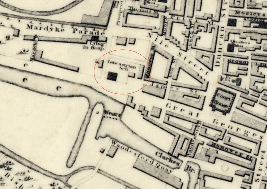
Contents
1.    Introduction .....................................................................................................................................................1

2.    Methodology .....................................................................................................................................................3

3.    Context ................................................................................................................................................................6

4.    Description of site ....................................................................................................................................... 14

5.    Assessment of impact ................................................................................................................................ 16

6.    Conclusions and recommendations ..................................................................................................... 17

7.    References/sources .................................................................................................................................... 18

Appendix 1: Excavation Database Summaries ......................................................................................... 19

Appendix 2: Archaeological Inventory entries ......................................................................................... 23

                                                                                      Former Square Deal premises, Washington Street West, Cork
                                                                                                                 Archaeological Assessment                                        ii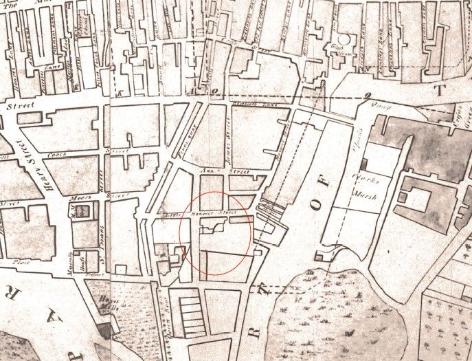
1. Introduction

John Cronin & Associates have been commissioned by IRE Real Estate Investment Partners Fund
II to provide an architectural heritage impact assessment of proposed works to construct a mixed-
use development on the site of the former Square Deals premises on Washington Street West in
Cork City. This site incorporates a protected structure, originally a boot factory, which fronts onto
Washington Street. The overall development site is bounded by Washington Street to the south,
Lynch’s Street to the north, Woods Street to the west and the rear of neighbouring properties
which front onto Little Hanover Street to the east (Figure 1). In 2018 planning permission was
granted for the redevelopment of the site (under Cork City Council Ref. 17/37406) and at present
(June 2020) a programme of demolition and site clearance is currently under way.

   Figure 1: Location of the subject site (indicated by red arrow) at former Lee Boot Factory (and more
                 recently ‘Square Deal’ furniture store) at Washington Street West, Cork

IRE Real Estate Investment Partners Fund II intend to apply to An Bord Pleanála for a 5-year
permission for a Strategic Housing Development (SHD) at The Former Square Deal Premises,
Washington Street West, Cork City.

The development will consist of modifications to the student accommodation development
permitted under Cork City Council Ref.’s 17/37406 comprising the following:
   1. The refurbishment and internal modifications of Protected Structure (PS451);
   2. The construction of a five and part six storey mixed-used development including 50 no.
       student apartments (increasing the number of bed-spaces on-site from 209 to 280 no. bed

                                                     Former Square Deal premises, Washington Street West, Cork
                                                                                Archaeological Assessment        1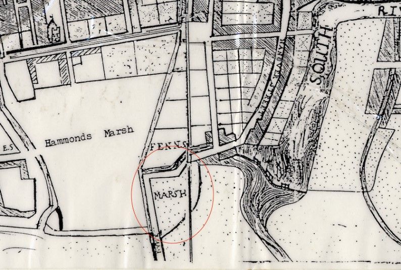
spaces). The development will include 10 no. 1 bed studios, 2 no. 2 bed studios, 2 no. 4
      bed apartments, 4 no. 5 bed apartments, 4no. 6 bed apartments, 10 no. 7 bed apartments
      and 18 no. 8 bed apartments, and ancillary student support facilities including laundry,
      gym, student amenity lounge/study, study rooms, library, private dining room, reception,
      management office, and comms rooms;
   3. The provision of a commercial/café unit at ground floor level;
   4. The provision of 140 no. bicycle parking spaces, plant room, switch room sub-station, and
      bin store; and
   5. All ancillary works including landscaped areas comprising internal courtyards and roof
      terraces at 4th floor and 5th level, road and footpath upgrades at Lynch’s Street and
      Woods Street, signage, site infrastructure, provision of plant and PV panels at roof level,
      and site development works.

This assessment has been compiled in order to examine the known and potential archaeological
resource of the subject site, and that of a study area extending 200m from the site boundary. The
assessment firstly outlines the methodology used in its compilation (Section 2) and then
provides an archaeological and historical context for the study area, including a summary of the
relevant legal and planning framework for the recorded and potential elements of the
archaeological resource within its environs (Section 3). The results of a site inspection are
described in Section 4, an assessment of impact is provided in Section 5, while conclusions and
recommendations are outlined in Section 6.

                                                Former Square Deal premises, Washington Street West, Cork
                                                                           Archaeological Assessment        2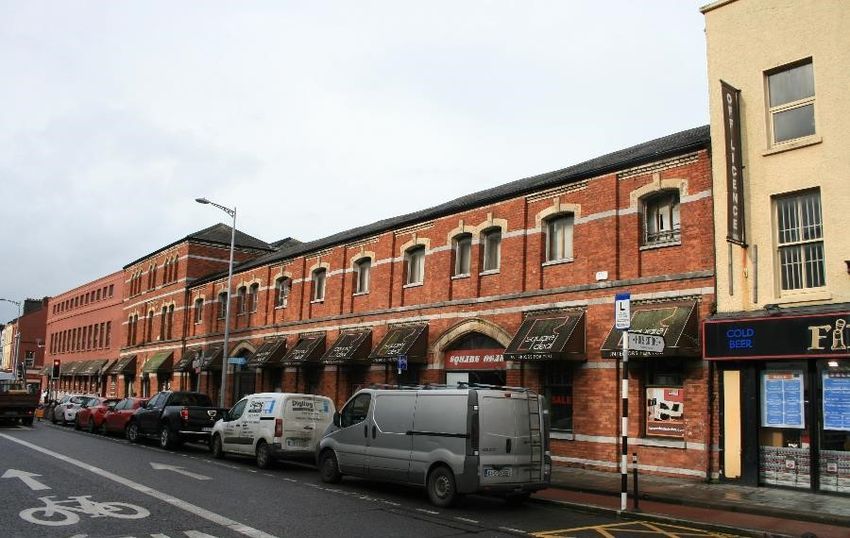
2. Methodology

This report is based on a programme of desktop research, site inspection and desk-based
assessment.

Desktop study
A desktop study assessment has been carried out in order to identify all known archaeological
sites, designated architectural heritage structures and other undesignated cultural heritage
assests within the study area. The principal sources reviewed for this assessment of the known
archaeological resource are the Sites and Monuments Record (SMR) and the Record of
Monuments and Places (RMP). Between 1984 and 1992, the Archaeological Survey of Ireland
(ASI) issued a series of county SMRs which lists known archaeological sites and places and this
record formed the basis for the statutory RMP established under Section 12 of the National
Monuments (Amendment) Act 1994. Similar in format to the SMRs (comprising a list and set of
maps), the RMPs were issued for each county in the State between 1995 and 1998. Archaeological
monuments included in the statutory RMP are legally protected and are generally referred to as
‘Recorded Monuments’.

The ASI has continued to record and add entries to the SMR and has developed an online database
and web viewer known as ‘Historic Environment Viewer’. This has been developed to enhance
the user’s experience by facilitating access to the database of the National Monuments Service’s
Sites and Monuments Record (SMR) and the National Inventory of Architectural Heritage (NIAH)
in a seamless one stop point of access for both data resources (Source: www.archaeology.ie).

In addition, the following sources were consulted as part of the desktop study:

   •   Cartographic Sources - The detail on cartographic sources can indicate past settlement
       and land use patterns in recent centuries and can also highlight the impact of modern
       developments and agricultural practices. This information can aid in the identification of
       the location and extent of unrecorded, or partially levelled, features of archaeological or
       architectural heritage interest. The cartographic sources examined for the study areas
       include various historic maps of Cork City, the 1st edition of the 6-inch Ordnance Survey
       (OS) maps (surveyed and published in the 1830s-40s) and the 25-inch OS maps (surveyed
       and published 1887-1913).

   •   Aerial photography – In parallel with the cartographic study, a review publicly-accessible
       aerial photographic sources from the Ordnance Survey, Google and Bing Maps was
       undertaken.

   •   Development Plans - The local authority development plans relevant to the study area was
       consulted as part of this assessment. These plans outline the local authorities’ policies for
       the conservation of the archaeological and architectural heritage resource and include the
       Record of Protected Structures (RPS) and any designated Architectural Conservation
       Areas (ACAs). The relevant development plan for the study area is the Cork City
       Development Plan 2015.

   •   Database of Irish Excavation Reports - The Database of Irish Excavation Reports contains
       summary accounts of all archaeological excavations carried out in Ireland from 1969 to
       2019.

                                                 Former Square Deal premises, Washington Street West, Cork
                                                                            Archaeological Assessment        3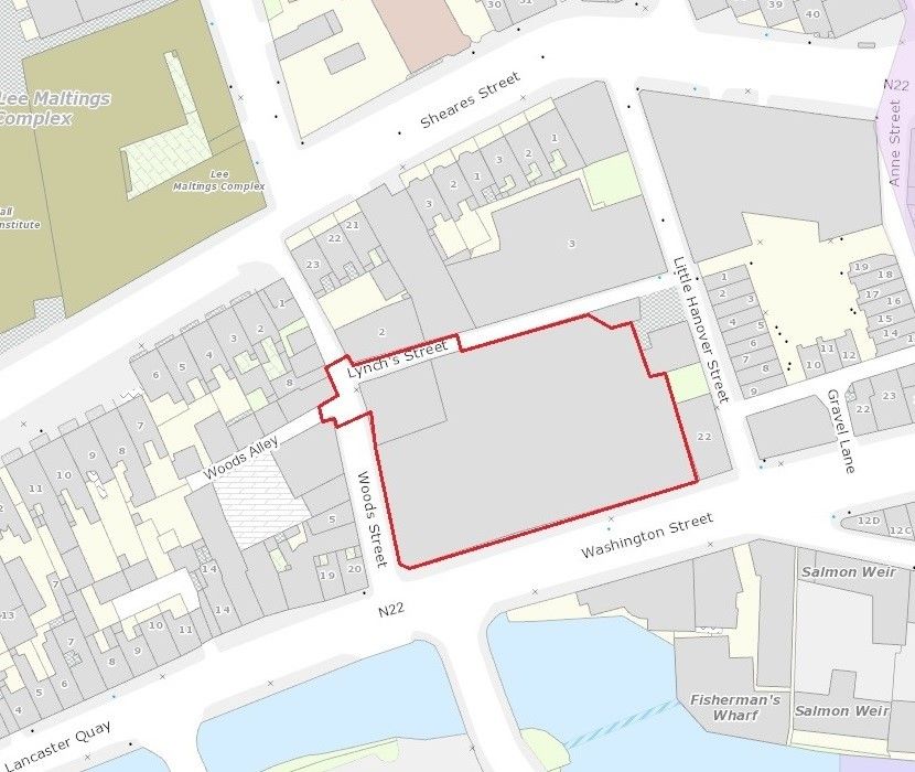
•   National Inventory of Architectural Heritage - The function of the National Inventory of
       Architectural Heritage (‘NIAH’) is to record built heritage structures within the Republic
       of Ireland and to advise local authorities in relation to structures of interest within their
       areas. The NIAH commissions surveys of sites of architectural significance to assist in
       evaluating structures to be included in the RPS. Listing on the NIAH does not necessarily
       carry any statutory protection but does highlight the culturally significant aspects of the
       structure which ought to be conserved.

   •   Irish Heritage Council: Heritage Map Viewer - This online mapping source collates various
       cultural heritage datasets and includes extracts from the National Museum of Ireland’s
       records of artefact discovery locations as well as datasets provided by, among others, the
       National Monuments Service, local authorities, the Royal Academy of Ireland and the
       Office of Public Works. Current data was accessed via www.heritagemaps.ie

   •   UNESCO World Heritage Sites and Tentative List - UNESCO seeks to encourage the
       identification, protection and preservation of cultural and natural heritage around the
       world considered to be of outstanding value to humanity. There are two world heritage
       sites in Ireland and a number of other significant sites are included in a Tentative List
       (2010) that has been put forward by Ireland for inclusion.

Types of impact
Impacts are categorised as either being direct, indirect or of no predicted impact. The criteria for
determining the nature of impacts are based on the following:
   − Direct Impact – where a cultural heritage site is physically located within the footprint
       of the scheme, which will result in its complete or partial removal.
   − Indirect Impact – where a cultural heritage site or its setting is located in close proximity
       to the footprint of the scheme.
   − No predicted impact – where the potential scheme will not adversely or positively affect
       a cultural heritage site.

A significance rating for these impacts is then applied; whether profound, significant, moderate,
slight, or imperceptible
    − A profound impact applies where mitigation would be unlikely to remove adverse effects
         that arise where a cultural heritage site is completely and irreversibly destroyed by a
         proposed development.
    − A significant impact applies when an impact, by its magnitude, duration or intensity,
         alters an important aspect of the environment. It applies where part of a cultural heritage
         site would be permanently impacted upon, leading to a loss of character, integrity and
         data about the feature/site.
    − A moderate impact applies when a change to a cultural heritage site is proposed that,
         though noticeable, does not compromise the integrity of the site and which is reversible.
         This arises where a cultural heritage site can be incorporated into a modern-day
         development without damage and where all procedures used to facilitate this are
         reversible.
    − A slight impact causes changes in the character of the environment which are not
         significant or profound and do not directly impact or affect a cultural heritage site.
    − An imperceptible impact applied where an impact is capable of measurement but does
         not carry noticeable consequences.

                                                  Former Square Deal premises, Washington Street West, Cork
                                                                             Archaeological Assessment        4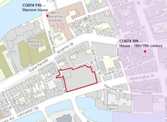
Site survey
The subject site was inspected by suitably qualified specialists from the offices of John Cronin and
Associates in February and April of 2017 and, furthermore in May 2020. The site was assessed in
terms of historic landscape, land use, presence and potential for undetected archaeological and
architectural heritage sites/features. No difficulties were encountered during the site survey. The
results of the site inspection are detailed in Section 4.

                                                  Former Square Deal premises, Washington Street West, Cork
                                                                             Archaeological Assessment        5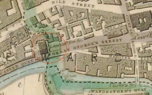
3. Context
Location
The subject site (Figure 2) was occupied by the ‘Square Deal’ furniture store until mid-2015. It
was originally constructed as the factory of the Lee Boot Company, which operated here from the
second half of the nineteenth century until the early 1980s. The buildings on the site front onto
Washington Street West to the south; to the west and north, it is bound by Woods Street and
Lynch’s Street respectively. To the east, the boundary is formed by the rear walls of properties
fronting onto Little Hanover Street. The proposed development site is located c.150m to the west
of the medieval historic core of Cork (CO074-034001-) and c.30m to the west of the
archaeological Zone of Notification which surrounds it. At present (June 2020) a programme of
demolition and site clearance is currently being undertaken (under Cork City Council Ref.
17/37406).

           Figure 2: General location of subject site with site boundary defined by the red line

Legal & Policy Framework
The management and protection of cultural heritage in Ireland is achieved through a framework
of national laws and policies which are in accordance with the provisions of the Valetta Treaty

                                                     Former Square Deal premises, Washington Street West, Cork
                                                                                Archaeological Assessment        6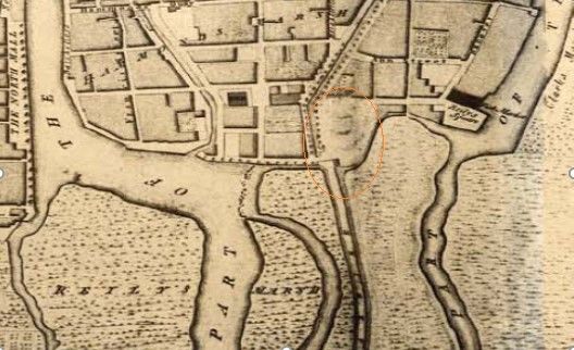
(1995) (formally the European Convention on the Protection of the Archaeological Heritage, 1992)
ratified by Ireland in 1997; the European Convention on the Protection of Architectural Heritage
(Granada Convention, 1985), ratified by Ireland in 1997; and the UNESCO Convention for the
Safeguarding of the Intangible Cultural Heritage, 2003, ratified by Ireland in 2015.

The locations of World Heritage Sites (Ireland) and the Tentative List of World Heritage Sites
submitted by the Irish State to UNESCO were reviewed and none are located within the region of
the country containing the study area.
 The national legal statutes and guidelines relevant to this assessment include:
    − National Monuments Act (1930) (and amendments in 1954, 1987, 1994 and 2004);
    − Heritage Act (1995);
    − National Cultural Institutions Act (1997);
    − Architectural Heritage (National Inventory) and Historic Monuments (Miscellaneous
       Provisions) Act (1999);
    − Planning and Development Act (2000);
    − Architectural Heritage Protection: Guidelines for Planning Authorities, Department of Arts,
       Heritage, and the Gaeltacht (2011); and
    − Framework and Principles for the Protection of the Archaeological Heritage, Department of
       Arts, Heritage, Gaeltacht and the Islands, 1999.

Archaeological Heritage
The administration of national policy in relation to archaeological heritage management is the
responsibility of the National Monuments Service (NMS) which is currently based in the
Department of Culture, Heritage and the Gaeltacht. The National Monuments Act of 1930, and its
Amendments, are the primary means of ensuring the satisfactory protection of the archaeological
resource. They include a number of provisions that are applied to secure the protection of
archaeological monuments. These include the designations of nationally significant sites as
National Monuments, the Register of Historic Monuments (RHM), the Record of Monuments and
Places (RMP), the Sites and Monuments Record (SMR), and the placing of Preservation Orders
and Temporary Preservation Orders on endangered sites.

Section 2 of the National Monuments Act, 1930 defines a National Monument as ‘a monument or
the remains of a monument, the preservation of which is a matter of national importance’. The State
may acquire or assume guardianship of examples through agreement with landowners or under
compulsory orders. Archaeological sites within the ownership of local authorities are also
deemed to be National Monuments. There are no National Monuments located within the study
area which comprises lands within 200m of the site boundary.

The National Monuments (Amendment) Act, 1994 made provision for the establishment of the
RMP, which comprises the known archaeological sites within the State. The RMP, which is based
on the earlier Register of Historic Monuments (RHM) and Sites and Monuments Record (SMR),
provides county-based lists of all recorded archaeological sites with accompanying maps. All RMP
sites receive statutory protection under the National Monuments Act 1994 and the NMS must be
given two months’ notice in advance of any work proposed at their locations. There are no
recorded archaeological sites (as recorded by the Historic Environment Viewer of the ASI) within
the proposed development site or within c.125m of its boundary, while there are three examples
within the surrounding 200m radius study area. These recorded archaeological sites are listed in
Table 1 and their published inventory descriptions are provided in Appendix 2.

                                                 Former Square Deal premises, Washington Street West, Cork
                                                                            Archaeological Assessment        7
The Cork City Development Plan 2015-2021 includes the following policies and objectives in
relation to the protection of the archaeological resource:
Objective 9.4 Archaeological Heritage: Cork City Council will aim to protect, record and promote the
rich archaeological heritage of the city.
Objective 9.5 Sites of Established Archaeological Interest: Cork City Council will protect and enhance
the archaeological value of the sites (and their settings) listed in the Record of Monuments and Places
(RMP).
Volume
Objective 9.6 Newly Discovered Sites: Cork City Council will protect and preserve archaeological sites
discovered since the publication of the Record of Monuments and Places (RMP).
Objective 9.7 Preservation of archaeological remains in-situ: In accordance with national policy (and
in the interests of sustainability) impacts on the buried archaeological environment should be avoided
where possible.
Objective 9.8 Development within the historic core: Where large-scale opportunity sites within the
medieval historic core are available for development a policy of minimising the impact on the
archaeological resource will be promoted. Any proposed development will be assessed on the level and
amount of undisturbed archaeology present on the site.
Archaeological and Historical Background
The proposed development site is located c.150m to the west of the medieval historic core of Cork
(CO074-034001-). Throughout medieval times and up until the late 18th century the area
surrounding the site consisted of tidal marshland. Development of this area to the west of the
medieval core progressed at a slower pace than the similar marshy environments to its east. John
Carty’s 1726 map of Cork demonstrates this imbalance showing significant new urban
development to the east of the medieval core, while to the west only tentative expansion into
‘Hammonds Marsh’ and ‘Fenns Marsh’ had been undertaken (Figure 3). By the time of the
production of John Rocque’s 1759 map of Cork, ‘Hammond’s Marsh’ to the immediate north of the
subject site is shown to be reclaimed and developed while ‘Fenn’s Marsh’ to the immediate east
has been substantially developed (Figure 4).
In order to reclaim these areas an embankment would have first been built around them to stem
the flow of tidal water into the marsh. Natural silt deposition further consolidated the areas
before drainage channels were constructed and introduced fills, generally consisting of clays and
rubble, were deposited to raise the ground level further, thus creating ‘made ground’. This ‘made
ground’ is present beneath modern levels throughout much of the central island of Cork City.
By the 1780s ‘Fenn’s Marsh’ had been reclaimed and a number of structures and open yards
occupied the subject site (Figure 5). Holt’s map of 1832 is the first to name the Lancastrian
School, built in 1812, at the site and also the first to show the modern street layout, the result of
the work of the Wide Street Commission who significantly altered the streetscape of the city
during the final decades of the 18th century (Figure 6). The Wide Street Commission were
recorded as having a yard next to the Lancastrian School in the 1840s, and it is likely this is the
yard shown at the site of the future Lee Boot Factory on the 1 st edition 6-inch Ordnance Survey
(OS) map, which was surveyed in 1841 (Figure 7). The 25-inch OS map of the area, surveyed in
Former Square Deal premises, Washington Street West, Cork
Archaeological Assessment 81899, shows both the Lancastrian School with sheds to the rear and the Lee Boot Factory
occupying the eastern half of the site (Figure 8).
Figure 3: Extract from Carthy’s 1726 map showing site as 'Fenn's Marsh', ‘Hammond’s Marsh’ to the north of
the subject site has yet to be developed
Figure 4: Extract from Rocque’s 1759 map, subject site remains undeveloped but ‘Hammond’s Marsh’ to the
north of the site has been reclaimed and developed, while portions of ‘Fenn’s Marsh’ to the east of the site
have also been developed
Former Square Deal premises, Washington Street West, Cork
Archaeological Assessment 9Figure 5: Murphy's 1789 map showing the subject site has been reclaimed and developed, yards and
structures are depicted on the site
Figure 6: Holt's 1832 map, showing Lancastrian School and modern street layout
Former Square Deal premises, Washington Street West, Cork
Archaeological Assessment 10Figure 7: First edition OS map showing Wide Street Commission yard at site of future Lee Boot factory in
1841
Figure 8: Second edition Ordnance Survey map showing Lee Boot Factory
Former Square Deal premises, Washington Street West, Cork
Archaeological Assessment 11Archaeological Context
The proposed development site is located c.150m to the west of the medieval historic core of Cork
(CO074-034001-) and c.30m to the west of the archaeological Zone of Notification which
surrounds it. There are no individual recorded archaeological sites in the immediate vicinity of
the subject site, with only two sites recorded by the Historic Monuments Viewer of the National
Monuments Service within 200 metres of the proposed development site. The closest of these two
sites, located c.125m to the east-northeast, is that of a terrace of 18th-century houses (CO074-109-
---) at Fenn’s Quay on the southern side of Sheares Street. The three houses that comprise the
terrace are virtually unaltered since the mid-18th century and contain some rare examples of early
Georgian interiors. The second recorded site is that of Cork’s old Mansion House -(CO074-110--),
which is located c.130 metres to the north of the subject site. It was built between 1766 and 1773
and served as the Lord Mayor’s official residence and a place of social interaction for Cork’s upper
class. In 1857, it became the Mercy Hospital after civic duties were transferred to the newly
constructed City Hall.
Table 1: Recorded archaeological sites within 200m of the proposed development site
SMR No. Class Townland ITM Ref (E, N)
CO074-034001- Historic town Cork City 567159, 571842
CO074-109---- House – 18th century Cork City 566987, 571872
CO074-110---- Mansion house Cork City 566762, 571952
Figure 9: Map depicting the locations of the recorded sites within 200m of the proposed development site,
purple shaded area represents the zone of archaeological potential for the historic town of Cork (CO074-
034001-)
Former Square Deal premises, Washington Street West, Cork
Archaeological Assessment 12Figure 10: Overview of the zones of archaeological potential with subject site indicated by orange circle
Excavations Database
The Excavations Database (www.excavations.ie) contains summarised accounts of all licensed
excavations undertaken in Ireland since 1969. Consultation of the database shows that a number
of properties in the wider vicinity of the development site have undergone archaeological testing
prior to redevelopment works in recent years. These include numbers 4-12 Coach Street and 41-
43 Sheares Street, a new development at 8-14 Millerd Street/12-13 Francis Street, a
redevelopment at the corner of Lynch’s Street and Little Hanover Street and a redevelopment at
Wandesford Quay. The stratigraphy of these sites generally comprised modern levels overlying
introduced rubble or ‘made ground’ layers which were deposited directly on top of estuarine silts,
clays and gravels. In all cases nothing of archaeological significance was encountered. An
archaeological excavation was also carried out by Rose Cleary of UCC at the Lee Maltings Complex
on Prospect Row. Structural elements associated with a 19th century millrace were also revealed
during the excavation. Finally, geotechnical investigations undertaken as part of the preliminary
phases of the Lower Lee Flood Relief Scheme (14E0139 ext., Murphy) revealed the inner faces of
the quay wall to the south of Hanover Street, the sub-strata here was shown to comprise
introduced rubble layers. See Appendix 1 below for full summaries.
Former Square Deal premises, Washington Street West, Cork
Archaeological Assessment 134. Description of site
The roughly rectangular site incorporates the premises of the former Lee Boot Manufacturing
Company and comprises the majority of a block of land between Washington Street to the south,
Lynch’s Street to the north, Woods Street to the west and the rear of properties fronting onto
Little Hanover Street to the east. The former factory building with the red-brick facade (which
accommodated part of the ‘Square Deal’ furniture store until mid-2015) is included on the Record
of Protected Structures (RPS) (RPS ref. PS451) within the Cork City Development Plan (2015-
2021) and is also listed the National Inventory of Architectural Heritage (NIAH) (Reg. no.
20503140) survey of architectural heritage in Cork City undertaken between 2003 and 2011.
The protected red-brick former boot factory building was described by the NIAH in the early
2000s when it functioned as a furniture store, as follows:
Victorian warehouse and office building, c. 1880, in use as furniture store. Comprises of two-
storey ten-bay block with pitched (slate) roof and three-storey three-bay block with (double)
hipped (slate) roof. Dog-tooth brickwork to eaves, above ground floor openings to two-
storey block, and also to central first floor bay of three-storey block. (Elaborately decorated
cast-iron gutters to administrative building with replacement rainwater goods to two-
storey factory structure). Red brick façade in English garden wall bond with limestone
banding and dressings and having brick pilasters. Engaged limestone columns to openings
on ground floor of three storey block. Limestone plinth course with brick band. Round
headed window openings with extended cills to second floor, camber headed openings with
cills to first floor, extended to three storey block. Windows to upper floors are a mix of timber
sliding sash single pane and replacement … glazed panels …. Former archways to ground
floor infilled with glazed timber screens, and modern glazed display windows to (lower part
of) openings. Street frontage with annexes to rear.
The NIAH appraised the brick-fronted part of the former Lee Boot Factory building as follows:
By the late 1890's there were four boot factories in the city, including this former Lee Boot
Manufacturing Company factory building. The high degree of mechanisation used in Cork's
boot factories created a thriving industry, this factory surviving until the 1980's. Historically
a very important building in the development of Cork industry. Retains a highly distinctive
and almost intact façade, despite the poor condition of some of the remaining timber sliding
sash windows, the inconsistent replacement of windows, and the use of awnings to the
ground floor display windows.
None of the buildings on the site are thought to be of specific historical importance other than the
part they have played in the industrial and social history of the local area. The brick fronted
portions described above are, however, due to be preserved and incorporated into the design of
the proposed development. The remaining structures, comprising warehouses and later
constructed factory buildings, which form the majority of the existing site, are (as of June 2020)
undergoing demolition (under Cork City Council planning reference 17/37406).
In essence, the current site can be categorised into six building types (see Figure 11 below), as
follows:
Former Square Deal premises, Washington Street West, Cork
Archaeological Assessment 14A c.1880 built, three-storey executive and administrative street-fronting building of
the boot factory
B c.1880 built, two-storey street-fronting factory building
C Late 19th-century single-storey north-lit factory floor building (approved for
demolition under Cork City Council planning reference 17/37406)
D Late 18th-century or early 19th-century sheds fronting onto Woods Street;
formerly copper works and re-roofed to serve as storage for boot factory and
subsequent furniture store (approved for demolition under Cork City Council
planning reference 17/37406)
E Early 20th-century sheds (approved for demolition under Cork City Council
planning reference 17/37406)
F 1919 street-fronting factory building (approved for demolition under Cork City
Council planning reference 17/37406)
D C
E B
A
F
Figure 11: Categorisation of the site by building type, buildings A and B are to be retained and incorporated
into the proposed development, the remaining buildings are in the process of being demolished under Cork
City Council planning reference 17/37406
(Source of aerial photography: Google maps)
Former Square Deal premises, Washington Street West, Cork
Archaeological Assessment 155. Assessment of impact
It is proposed to develop residential accommodation for third-level students on the site of the
former Lee Boot Manufacturing Company and later ‘Square Deal’ furniture store. Retention of the
Washington Street architectural detail of the two brick-fronted former factory buildings is a
central part of the design proposal with all other structures on the site (Blocks C – F in Figure 11)
currently being demolished as part of the previously granted planning application (Cork City
Council Ref. 17/37406).
There will be no substantial sub-surface/basement element within the proposed development,
as a result, no large-scale deep bulk excavations of the underlying sub-strata will be required.
Ground excavations and reductions on the site will be confined to the excavation of foundation
trenches and elevator pits with much of the new structure being supported on piles.
As the site of the proposed development is located over 150m to the west of the medieval historic
core of Cork (CO074-034001-) and c.30m to the west of the archaeological Zone of Notification
which surrounds it, as there are no recorded archaeological sites within 125m of the subject site
and as all of the previous archaeological investigations in the immediate vicinity of the subject
site uncovered nothing of archaeological significance, it can be determined that the proposed
development will have no impact on the recorded archaeological heritage resource.
Furthermore, due to the factors outlined above the subject site can be considered to be of low
archaeological potential.
However, the possibility for evidence of archaeological activity of a more short-term nature on
old riverine or marshland sites cannot be discounted as such locations were highly attractive
since the early prehistoric period, as both a food and transport resource. This has been evinced
by the results of archaeological monitoring of bulk soil removal at a development site in the
Academy St/Emmet Place area of Cork City where a worked timber and struck flint were found
at a depth of –1.928m OD (Sutton 2008). Archaeological monitoring close to the banks of the
River Liffey has uncovered the remains of Mesolithic fish traps and other prehistoric sites have
been uncovered beneath post-medieval reclamation levels along the Dublin quays (e.g. McQuade
2007 and Lohan 2007). During the Bronze and Iron Ages riverine and marsh environments were
occasionally the sites of ritual deposition and of particular note are the famous Cork Horns which
were discovered in 1909 near the south jetties in the Victoria Road area to the east of Albert Quay.
Consequently, it is recommended that all substantial ground reductions, associated with the
excavation of foundation trenches, elevator pits or similar features at the subject site, be
archaeologically monitored by a suitably qualified archaeologist. If any archaeological features
or deposits are uncovered during these works, then ground reduction works should be
suspended in the area pending consultation and agreement with Cork City Council and the
National Monuments Service on the appropriate mitigation strategy.
Former Square Deal premises, Washington Street West, Cork
Archaeological Assessment 166. Conclusions and recommendations
This archaeological assessment has determined that the proposed development at the site of the
former Square Deal premises, Washington Street West, Cork will have no impact on the recorded
archaeological heritage resource, while the proposed development site can be considered to be
of low archaeological potential.
The proposed development design does not include any substantial/expansive sub-surface or
basement elements; this limits the amount of ground excavations/reductions that will be
required during construction. However, the possibility of archaeological remains surviving
beneath the modern stratigraphy cannot be discounted. Similar urban site types (e.g. riverine or
marshland sites) have in the past produced evidence of pre-historic activity and preservation
conditions for artefacts of any age are generally good within the underlying clay layers.
It is therefore recommended that all substantial ground excavations/reductions, associated with
the excavation of foundation trenches, elevator pits or similar features at the subject site, be
archaeologically monitored by a suitably qualified archaeologist. If any archaeological features
or deposits are uncovered during these works, then ground reduction works should be
suspended in the area pending consultation and agreement with Cork City Council and the
National Monuments Service on the appropriate mitigation strategy.
Former Square Deal premises, Washington Street West, Cork
Archaeological Assessment 177. References/sources
Published works
Bradley, J et al. (1985) Urban Archaeological Survey Part XIV Cork City. Office of Public Works.
Unpublished
Cork City Council (2015) Cork City Development Plan 2015-2021.
Crowley, J. (ed.) (2005) ‘Atlas of Cork City’, Cork University Press.
Jefferies, H. (2010) ‘A New History of Cork’, The History Press Ireland.
John Cronin and Associates (2017) ‘The former Square Deal premises, Washington St. West, Cork
– Architectural Heritage Impact Assessment’, unpublished
Lohan, K. (2007) ‘Clancy Barracks, Islandbridge, Dublin’, www.excavations.ie
McQuade, M. (2007) ‘Spencer Dock, North Wall Quay, Dublin’, www.excavations.ie
O’Kelly, M. (1961) ‘The Cork Horns, the Petrie Crown and the Bann Disc’, Journal of the Cork
Historical and Archaeological Society Journal, Vol. 66, 1-12.
Sutton, D. (2008) ‘St Patrick’s Street/Academy Street/Emmet Place/Bowling Green
Street/Faulkner’s Lane, Cork’, www.excavations.ie
Internet resources
Cork City Development Plan (2015-2021)
http://www.corkcitydevelopmentplan.ie
Database of Irish Archaeological Excavations
http://www.excavations.ie/
Department of Culture, Heritage and the Gaeltacht’s Historic Environment Viewer
http://webgis.archaeology.ie/historicenvironment/
National Inventory of Architectural Heritage (NIAH)
http://www.buildingsofireland.ie/Surveys/Buildings/
Cork Past and Present – historic maps and sources
http://www.corkpastandpresent.ie/
Heritage Map Viewer - various interactive heritage maps, accessed 15/05/19, 16/05/19,
https://heritagemaps.ie/WebApps/HeritageMaps/index.html
Google Earth
https://earth.google.com
Former Square Deal premises, Washington Street West, Cork
Archaeological Assessment 18Appendix 1: Excavation Database Summaries
Site Name Licence and Summary
Author
Wandesford Quay 98E0205 A site assessment consisting of two test-trenches was carried
Sheila Lane out on 9 May 1998. The trenches ran north-south across the
site. They were opened to a depth of 3m and were found to
contain loose rubble fill dating to the 19th and 20th centuries.
No finds or features of archaeological significance were noted.
4-12 Coach St. and 00E0355 Testing took place at a site off Coach Street and to the rear of
41-43 Sheares St., Sheila Lane Sheares Street, Cork. The site lies outside of and c. 200m to the
Cork west of the medieval walled city of Cork. Two test-trenches
were initially excavated at Coach Street after several single-
storey buildings were demolished. The buildings on Sheares
Street were then deemed to be unstable by Cork Corporation
and were demolished. Two further test-trenches were
excavated in this area. In all trenches the natural river gravels
were exposed beneath a thick layer (0.8m) of building rubble.
There was no evidence for houses or archaeological habitation
levels on the site.
Lynch’s 03E1675 Four test-trenches were excavated prior to the construction of
Street/Little Tony Cummins an apartment building on the corner of Lynch’s Street/Little
Hanover Street, Hanover Street in the area to the west of the medieval walled
Cork city of Cork. This area was marshland prior to 18th-century
reclamation works and was thereafter occupied by a number of
factory buildings. The uppermost fill measured up to 0.5m deep
and was a modern demolition rubble layer. This overlay a 1m-
deep sandy layer containing brick and mortar and this sealed
the underlying natural subsoil, which was a dark-grey boulder
clay. This was present to a depth of 2.4m below modern ground
level, where excavation halted. There were no archaeological
features or finds uncovered.
Lee 05E0685 The excavation aim was to determine if subsurface remains of a
Maltings/Prospect Rose M. Cleary millrace were extant in a complex of 19th-century maltings. The
Row excavation trench was located within the footprint of part of a
proposed building, at the intersection of the millrace and a
footbridge as indicated on historic maps. The top of the millrace
wall was located c. 0.2–0.3m beneath the modern ground
surface. The wall was 0.5–1.1m to the east of the location on the
historical mapping and was angled rather than straight.
The wall was irregularly coursed, mortar-bonded limestone
blocks. These varied in size from 0.1 to 0.5m in length by 0.1 to
0.25m in height. The wall thickness was 0.6–0.7m and the wall
was built in a construction trench that extended for 0.2m
beyond the eastern edge of the top of the wall. The wall was
battered from the base to the top and the angle of incline was 6°
from the base to the top.
The footing for the footbridge survived at the north end of the
trench as two niches in the wall with an intermediary distance
of c. 0.8m. These niches presumably housed the supporting
framework or trusses for a timber bridge. The niches were c.
0.8m wide and the southern niche was damaged on the south
side.
Former Square Deal premises, Washington Street West, Cork
Archaeological Assessment 19Site Name Licence and Summary
Author
A ceramic pipe with a diameter of c. 2m was recorded on the
south side of the exposed wall, close to the section where
realignment occurred on the line of the wall. This appears to
have been an original feature and was integral to the wall
construction. The pipe drained into the millrace. Three other
pipes were recorded in the wall and appeared to post-date wall
construction. Pipe 2 was at the northern end and the associated
pipe trench cut through the stonework of the wall. Pipes 3 and 4
were within the overburden over the millrace wall and the
trench for Pipe 3 cut into the top of the wall.
A brick setting with two concrete slabs atop was recorded to the
south of the wall. The brick was cut through by the trench for
Pipe 3. The bricks were red brick and may have formed part of a
floor for the building shown on the 1934 edition of the OS map.
Limestone flags were recorded on the north end of the wall.
These may be either a repair to the millrace wall or part of a
later structure. The trench for Pipe 2 was below these and pre-
dated the insertion of the flags.
Two timber piles were exposed during excavation. These
occurred to the west of the line of the millrace wall and may be
unrelated to it. The piles were 4.3m apart and the southern pile
was 0.25m west of the millrace wall and that to the north was
0.2m west of the wall. The north pile stood to a height of 1m
above the base of the trench and the southern protruded from
the trench infill for 0.1m. Both piles were c. 1.2m below the top
of the millrace wall. Their function is obscure. A timber plank
was exposed at the northern end of the trench. This was left in
situ and appeared to abut the millrace wall and again be
unrelated to the wall.
The infill layers of the millrace are post-1903 and comprise
several lenses of modern fill. These included hardcore,
stone/brick construction debris and material from demolished
buildings, possibly those to the east where kilns were once
housed. This material contained firebricks similar to those used
in ovens.
Lower Lee Flood 14E0139 ext. Monitoring of Phase 4 of site investigation works associated
Relief Scheme, David Murphy with the proposed Lower Lee Flood Relief Scheme was
Cork undertaken between May and November of 2017. In total, 23
locations were monitored during Phase 4 of geo-technical site
investigation works. These investigations comprised 13
boreholes, 7 slit trenches and 3 trial pits. Excluding two slit
trenches which were excavated within the zone of notification
of the Customs House (CO074-118—-), all other monitored site
investigations were undertaken within the primary and
secondary Zones of Archaeological Potential of Cork City. Five
investigations were undertaken along the quays adjacent to the
north channel of the River Lee, twelve investigations were
undertaken along the quays adjacent to the south channel of the
river, with a further six investigations undertaken at more
central locations between the two river channels. Only one site
investigation was undertaken within the extent of the walled
medieval city (4BH039 – Bishop Lucey Park).
The excavation of the trial pits did not expose any sub-surface
traces of earlier quay or mooring structures at the investigated
locations. The inner face of the quay walls was partially
revealed in six locations (4ST025 – Sullivan’s Quay, 4ST026 –
Former Square Deal premises, Washington Street West, Cork
Archaeological Assessment 20Site Name Licence and Summary
Author
Crosse’s Green Quay (South), 4ST027 – Crosse’s Green Quay
(North), 4TP003 – Pope’s Quay, TP014 – Hanover St (East),
4TP015 – Hanover St (West)) and generally consisted of the
inner facades of the cut limestone blocks which varied from
ashlar to more roughly cut varieties. Sub-surface, the quay wall
foundations were observed to step outwards beyond their
upstanding extent at a number of these locations.
The upper level of the exposed reclamation deposits were
regularly disturbed by modern services and contained frequent
limestone, sandstone and brick fragments as well as post-
medieval and early modern inclusions which, in turn, were
contained within combinations of silt and clay matrices. Sub-
surface walls dating to the post-medieval period were revealed
at Crosse’s Green South (4BH017, 4ST026) and a solid
obstruction was encountered during boring of 4BH040 at a
depth of 3.5m below modern ground level in St Augustine
Street. Although the obstruction was encountered at a
significant depth, all of the 16th- and 17th- century maps of
Cork depict a tower in the general location of St Augustine
Street; foundations of such a tower would likely have extended
eastwards beyond the recorded line of the wall and as such a
possible association cannot be discounted.
Possible archaeological strata in the form of oyster shell-rich
silty clays were revealed at both the northern end of Barracks
Street (4BH015) and at Bishop Lucey Park (4BH039); both
locations are within the medieval historic core of Cork and
excavations in the immediate vicinity of both boreholes
uncovered archaeological stratigraphy dating as far back as the
late Hiberno-Norse period.
It should be noted that due to the limited areas of site
investigations, combined with the safety constraints that
precluded close inspection of the exposed stratigraphy, the
monitoring of the site investigations was not undertaken as a
conclusive archaeological impact assessment but rather to
ensure that excavations did not negatively impact on any
unrecorded archaeological or built heritage features. Further
phases of site investigation works are planned.
8-14 Millerd St., 17E0618 In order to comply with Condition 7(b) of the grant of
12-13 Francis St., David Murphy permission from Cork City Council (Ref no. 16/37142),
Cork archaeological testing was undertaken at the site of a proposed
apartment development at 8-14 Millerd Street/12-13 Francis
Street, Cork on Thursday 14th December 2017. The layout of
the archaeological investigations at the subject site took the
form of three linear test trenches, measuring between 1m and
1.2m in width and totaling 37m in length. The test trenches
were excavated within the footprint of the upstanding
warehouse structures which currently occupy the subject site. It
was necessary to mechanically cut the existing reinforced
concrete floor slab in each trench location prior to its
excavation.
Trench 1 (T.1) measured 17m in length and was excavated in an
east-northeast to west-southwest direction within the northern
warehouse structure. Trenches 2 and 3 (T.2, T.3) were
excavated in a north-northwest to south-southeast direction
within an accessible area of southern warehouse structure. Both
trenches were 10m in length and were spaced 8m apart, the
Former Square Deal premises, Washington Street West, Cork
Archaeological Assessment 21Site Name Licence and Summary
Author
presence of the remnants of metal girders encased in reinforced
concrete and a concrete encased service pipe near the centre of
both T.2 and T.3 required a 3m long section south of the
midpoint of both trenches to remain unexcavated. While
nothing of archaeological significance was revealed within the
excavated trenches, early modern building foundations were
revealed, primarily within T.1 but also within T.2. The
foundations which were composed of brick, sandstone and
limestone were revealed at depths of between 0.40m and 0.85m
below modern surface level (BMSL). Within T.1, at the extreme
east-north-eastern end of the trench, a well-built stone drain
was also revealed at a depth of 1.13m BMSL. The drain was
orientated in a northeast to southwest direction, it underlay the
layers of demolition debris but truncated an underlying deposit
of introduced greyish brown silty gravel. The side walls of the
drain were primarily constructed with mortar bonded
sandstones with lesser amounts of slate evident, while its
capstones comprised thin limestone slabs. Its full width was not
revealed but within the trench it measured at least 0.9m wide.
The dimensions of one of the best-preserved limestone
capstones was 0.46m x 0.31m x 40mm. Partial removal of one of
the capstones revealed that the drain was silted up, containing a
moist, dark grey, clayey silt. Probing of this silt revealed the
presence of a probable base stone c.0.20m below the underside
of the capstones. The drain was not removed and remains in-
situ.
The revealed features were constructed within and upon the
post-medieval reclamation deposits which consisted of
introduced deposits of demolition debris, gravels and clays.
These deposits were shown to directly overly a sterile, greenish
grey, estuarine clay which was revealed at a depth of between
1.7m and 2.3m below modern surface level (BMSL). The
revealed foundation features and stone drain remain in-situ.
Former Square Deal premises, Washington Street West, Cork
Archaeological Assessment 22Appendix 2: Archaeological Inventory entries
(Archaeological Inventory descriptions of recorded archaeological sites located within 100m of the
boundaries of the proposed development site)
CO074-034001-
Class: Historic town
Townland: CORK CITY
Scheduled for inclusion in the next revision of the RMP: Yes
Description: Earliest historic settlement at Cork was monastery of St Fin Barre, founded 6th or
early 7th century (Gwynn and Hadcock 1970, 66). Historical references to Viking settlement date
from 846 AD (Jefferies 1985, 15); probably located on S bank of Lee opposite South Gate Bridge
(CO074-03412-), however recent excavation in this area produced no material earlier than 12th
century (O'Brien 1990). Walled town built on two islands (N and S) in marshy section of river Lee.
S island enclosed by 1182, reserved to the Crown; N island, called Dungarvan, regarded as suburb;
within walled area by 13th century (Bradley et al. 1985, 25; Candon 1985; Thomas 1992, vol. 2,
62). Bridges linking islands to mainland at N and S ends indicate existence of North and South
Main Streets. The number of religious foundations established in late 12th and 13th centuries is
a measure of wealth and urban expansion of Cork at this time. Suburbs appear to have declined
during 15th century and in 16th century city seems to have occupied little more than area inside
medieval walls. Period after 1550 saw economic revival with expanding overseas trade. Old
suburbs re-emerged; land reclaimed from marshes to E and W. Return of customs and excise
duties for both 1664 and 1668 indicate Cork now second port of Ireland, after Dublin. City
besieged by Williamites in 1690; considerable damage caused within city; large gap made in SE
section of city wall (O Murchadha 1990). Despite destructive Williamite siege, 17th century
period of prosperity; economic improvement continued in 18th century with further
reclamations to E and W; many of the watercourses formerly dividing city into islands covered
over at this time and city centre took on shape which largely remains today.
CO074-109----
Class: House - 18th/19th century
Townland: CORK CITY
Scheduled for inclusion in the next revision of the RMP: Yes
Description: On S side of Sheares' Street; brick-built 12-bay, 3-storey terrace; shallow reveals to
windows; ground floor occupied by small shop units. Recently described as 'probably the oldest
surviving terrace of houses in Ireland, 2-5 Sheares Street is virtually unaltered since the mid-18th
century... the buildings contain some rare examples of early Georgian interiors' (Anon 1992).
CO074-110----
Class: Mansion house
Townland: CORK CITY
Scheduled for inclusion in the next revision of the RMP: Yes
Description: Formerly the Mayoralty House, now part of the Mercy Hospital. Designed by Davis
Duckart, built 1766-73; entrance front faces N: 'it has a small Doric centre piece on the basement
Former Square Deal premises, Washington Street West, Cork
Archaeological Assessment 23ground floor, but the three floors above have an unusual fenestration. Conventional two bays on
either side flank the central arrangement of two Venetian windows capped by a single, originally
round, window with two vertically ovals on either side. The interior central axis is pivoted on an
elaborate, mahogany-ramped staircase, and the main reception rooms, richly stuccoed by one
Patrick Osborne, open off these stairs' (Glin 1967, 737).
Former Square Deal premises, Washington Street West, Cork
Archaeological Assessment 24You can also read