STATEMENT OF BASIS ON WHICH THE VICTORIAN ABORIGINAL HERITAGE COUNCIL CONSIDERS IT WOULD BE APPROPRIATE TO VARY THE REGISTRATION AREA OF BUNURONG ...
←
→
Page content transcription
If your browser does not render page correctly, please read the page content below
STATEMENT OF BASIS ON WHICH THE VICTORIAN ABORIGINAL
           HERITAGE COUNCIL CONSIDERS IT WOULD BE APPROPRIATE TO
           VARY THE REGISTRATION AREA OF BUNURONG LAND COUNCIL
           ABORIGINAL CORPORATION

           DATE OF PROPOSAL: 7 June 2021

           1       Council’s View
           The Victorian Aboriginal Heritage Council (Council) has formed the view that it would be
           appropriate to exercise its power pursuant to section 155 of the Aboriginal Heritage Act 2006
           (Act)to vary the registration area of Bunurong Land Council Aboriginal Corporation
           (BLCAC). The variation Council considers appropriate relates to some, but not all, of an
           extension of its registration area sought by BLCAC 1.

           2       Procedural Background
           The following section provides a summary of the procedural steps leading to Council’s
           eventual substantive consideration of whether to exercise its power to vary the area of the
           BLCAC’s RAP application area.

           In 2017 BLCAC applied to Council for appointment as a registered Aboriginal party (RAP)
           under s 150 of the Act. Council acknowledged receipt of BLCAC’s RAP application on 24
           February 2017. BLCAC’s RAP application was determined for part of the area it applied for
           on 19 July 2017. Council was advised shortly thereafter that BLCAC and Wurundjeri Woi
           Wurrung Cultural Heritage Aboriginal Corporation (WWW) had entered negotiations
           regarding overlapping areas of interest in respect of that part of BLCAC’s application which
           Council had not determined in its favour. These negotiations were facilitated through the
           Victorian Government’s Right People for Country program (RPfC).

           Council acknowledged receipt on 25 September 2017 of correspondence from BLCAC
           advising that all negotiations between the parties had been put on hold, for some 6 to 12
           months, at the request of WWW.

           Council understood that negotiations facilitated by RPfC progressed throughout 2019.

           Council wrote to BLCAC on 17 December 2019 informing it that any unresolved boundary
           registration issues (arising from the 2017 RAP Application) would be resolved pursuant to
           under section 155 of the Act.

           On 23 April 2020 Council gave public notice of BLCAC and WWW negotiations within what
           was described as “the Decision Area” (the area of BLCAC original RAP application that was
           not included in the original BLCAC RAP registration boundary), to seek current views of any
           affected party in relation to the Decision Area.

           1
            Whilst Council has discretion under s.155 to vary the registration area of a RAP of its own motion in practice
           consideration of this discretion to vary also occurs due to a request from the relevant RAP. Council has
           published a policy and procedure to assist RAP’s who make such a request.

OFFICIAL
Due to concerns regarding COVID-19 during 2020 and the ability of parties to physically
           meet, Council undertook to refrain from making a decision on the BLCAC variation request.

           On 26 August 2020 Council acknowledged receipt of a WWW request for variation pursuant
           to section 155 of the Act. The area of the WWW request for variation substantially
           overlapped with the undetermined part of the BLCAC’s 2017 application for registration.

           Given this overlap, Council had to form a view as to whether and how it should exercise its
           power of variation under s.155. Accordingly, Council wrote to both parties on 13 January
           2021 issuing a direction seeking all material relevant to each party’s respective claims.

           3      Area considered by Council under s.155
           The original RAP appointment application from BLCAC was made on 24 February 2017. The
           original application was submitted in the form of a section 150 application for registration as
           a RAP. That application was part determined and BLCAC was first appointed as a RAP for
           that part on 19 July 2017. As an existing RAP at the time of Council’s current consideration,
           BLCAC’s undetermined application area was considered as a possible registration boundary
           variation pursuant to section 155 of the Act (Attachment 1). As noted above BLCAC was
           advised of Council’s intention to consider the balance of its original RAP application as a
           request for boundary variation under s 155 of the Act on 17 December 2019.

           Gunaikurnai Land and Waters Aboriginal Corporation (GLaWAC) wrote to Council in mid-
           2020 raising concerns over the BLCAC’s application area’s partial overlap with GLaWAC’s
           own historical RAP applications.

           Wadawurrung Traditional Owners Aboriginal Corporation (WTOAC) wrote to Council mid-
           2020 raising concerns over the BLCAC’s application area’s overlap with asserted interest of
           WTOAC over the waters in the west of Port Phillip Bay nearby WTOAC’s RAP area.

            On balance, Council considered it was simplest for the purposes of its consideration of any
           s.155 variation to excise all areas of asserted interest by GLaWAC and WTOAC.
           Attachment 2 depicts the current Proposal Area. Council will communicate with affected
           parties shortly with a process for developing a proposal in relation those areas of BLCAC’s
           boundary variation request that have been excised from this current proposal.

           4      Council’s approach to s.155.

           BLCAC is not a registered native title holder for the proposed boundary variation area within
           the meaning of section 151(2) of the Act, and has not entered into a RSA in relation to the
           Decision Area within the meaning of section 151(2A) of the Act. As such, Council is not
           obliged to approve BLCAC’s application over the proposed boundary variation area to align
           with sections 151(2) or 151(2A) of the Act.

           Council has broad discretionary power to make a variation to the registration of a RAP,
           including geographic boundary variations under s 155(2). Section 155 (1) of the Act requires
           the consent of the affected RAP to a variation of its registration boundary. As the boundary
           variation proposed by Council is to vary BLCAC’s registration boundary to a somewhat
           lesser extent than was sought by BLCAC it will be necessary for Council to write to BLCAC
           to confirm BLCAC does in fact consent to the boundary variation proposed by Council. No
           other RAPs are within the proposed boundary variation area therefore no other consent is
           required.

           It is clear Council’s discretion to vary a registration area under s.155 must be exercised
           according to law.

                                                                                                           2

OFFICIAL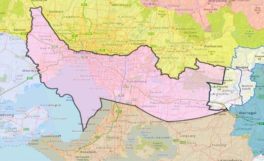
In forming its view about how its discretion should be exercised Council had regard to:

                  (a) the overall scheme and purposes of the Act 2.
                  (b) the requirements under ss.150 and 151 [in so far as they are relevant to a variation
                      as opposed to a first registration].
                  (c) consistent with (a) and (b) Council considered factors such as BLCAC’s relationship
                      to the undetermined part of the application area including traditional or familial links,
                      its representativeness and inclusivity, any demonstrated expertise in managing and
                      protecting Aboriginal cultural heritage in the area under consideration and its capacity
                      to discharge its statutory functions in general
                  (d) the contentions of other interested parties
                  (e) Its obligations under the Charter of Human Rights and Responsibilities Act 2006 (Vic)
                  (f) Whether BLCAC is prepared to consent to the variation Council thought appropriate.

           5. The Material considered
           When forming its view as to how its discretion under s.155 should be exercised in this case
           Council had regard to the material in Schedule 1 to this Statement.

           As the Act also requires Council members to be Aboriginal persons with demonstrable
           traditional or familial links to an area within Victoria and have relevant experience or
           knowledge of Aboriginal cultural heritage in Victoria (s 131(3)(a) and (c)) Council uses these
           attributes when considering the material before it and forming its views. Interested parties
           are expressly made aware of this in Council’s publication Section 155 Requests for
           Variations of Registration Policy and Procedure.

           6. Proposal Area
           The following section particularises the area Council considers would be appropriate to add
           to BLCAC’s existing registration area. The relevant area (Proposal Area) is shown in the
           attached map (Attachment 2) and is described as:

                  •   The Proposal Area is bounded in the north-west by the Werribee River at the point an
                      extension of Middle Rd would meet the Werribee River. The Proposal Area continues
                      north-east to include all of Mt Cottrell at or above 160m above sea level as a shared
                      area with WWW. The Proposal Area extends north-easterly to include the southern
                      face of Mt Atkinson, then continues in a south-easterly direction to include the
                      localities of Derrimut, Laverton North, Tottenham and Yarraville meeting the original
                      point of convergence of the Yarra River and the Maribyrnong River. This point is
                      immediately to the south of the Footscray Rd bridge. The area extends in a south-
                      easterly direction to include Coode Island and Fisherman’s Bend to the high ground
                      in South Melbourne. The Proposal Area then extends easterly to include Port
                      Melbourne, Albert Park, Middle Park, Royal Botanic Gardens to the highest point in
                      the landscape at Government House. The area then tends south-east following a
                      section of the southern margin of the Yarra River catchment to include the suburbs of
                      St Kilda, St Kilda East, Caulfield and Glen Huntly. The Proposal Area then follows the
                      southern margin of the Gardiners Creek catchment to Wheelers Hill and includes the
                      suburbs of Bentleigh East, Clayton and Notting Hill. From Wheelers Hill the area
                      extends east across a section of the floodplain of Dandenong Creek including the
                      localities of Dandenong, Lysterfield Park and Narre Warren North and meets up with
                      a point on the western margin of the Cardinia Creek catchment at Belgrave Heights.

           2
               The purposes are set out in s.1 of the Act

                                                                                                              3

OFFICIAL
From this point the proposal area follows the northern margins of the Cardinia Creek,
Toomuc Creek and the Bunyip River catchments include the Cardinia Reservoir and
the localities of Beaconsfield Upper, Mount Burnett, Gembrook South and the Bunyip
State Park. The most north-easterly point of the proposal area is the point at which
the Bunyip River catchment meets the GLaWAC partial overlap area. The proposal
area follows the western margin of the excised overlap area to the south, then to the
west to the Bunyip State Park, to a point north of the township of Tonimbuk at which
several unnamed creeks converge with the Bunyip River. From this point the
proposal area follows the Bunyip River south to Nar Nar Goon-Longwarry Rd, then
east to the township of Longwarry. The area extends to the south for approximately 3
kms along Koo Wee Rup-Longwarry Rd then easterly to the Princes Hwy just north of
the township of Drouin and meets with the existing Bunurong RAP boundary. The
Proposal Area then follows the existing Bunurong RAP area west to the mouth of the
Patterson River then south to a point off the coast of Mt Martha. The area then
extends in a north-westerly direction across Port Phillip Bay to meet at a point on a
currently submerged section of the former course of the Werribee River. The area
follows this submerged former course of the Werribee to the mouth of the current
Werribee River and continues along the Werribee River to the point the variation
begins.
The Proposal Area entirely overlaps:
• the area referred to as Zone 1 within WWW application for variation pursuant to
section 155 of the Act lodged 26 August 2020.
• asserted interests of Boonwurrung Land and Sea Council (Aboriginal Corporation)
(BLSC).
• asserted interests of Ms Pauline Mullett on behalf of what Ms Mullett describes as the
“Kurnai Nations”.
7. Material Questions of Fact
Based on the material in Schedule 1 and its own cultural knowledge Council satisfied itself
as to the following material questions of fact in relation to the Proposal Area. ..
i) Whether BLCAC represents Bunurong People
BLCAC is not a Prescribed Body Corporate under the Native Title Act 1993 (Cth) (NTA).
BLCAC does not hold native title on behalf of the Bunurong People and there are no other
native title holders (within the definition of the Act and the NTA) within the Proposal Area.
A person is eligible for BLCAC membership if the person is at least 18 years of age,
an Aboriginal person who is a descendant of one of the five known Bunurong Apical
Ancestors (Elizabeth Maynard, Eliza Nowan, Jane Foster, Marjorie Munro and Louisa
Briggs), and able to demonstrate connection to Bunurong People.
The BLCAC Rule Book provides that Bunurong People ‘means Aboriginal persons of
Bunurong descent who identify as Bunurong and are accepted by the directors as Bunurong
people. Bunurong is also known as Boonerwrung, Boonwurrung, Bonurong etc’.
The BLCAC Rule Book provides that a fundamental objective of the Corporation is ‘to relieve
poverty, sickness, suffering, distress, misfortune, destitution and helplessness amongst the
Bunurong people, recognizing that such poverty, sickness, suffering, distress, misfortune,
4
OFFICIALdestitution and helplessness result from Bunurong people have been progressively
dispossessed of their lands and / or waters without compensation, as a consequence of
which they have become socially and economically disempowered’.
Council noted Rule 7.2(b) (Directors) of BLCAC’s rule book which states that its Board
comprises directors elected as representatives of the Bunurong community, and that each of
the five (5) Bunurong Apical Ancestors shall be acknowledged and represented on the board
of directors. The corporation shall have a minimum of 10 directors and a maximum of 12
directors requiring each of the five (5) Apical Ancestor Groups to vote and appoint not more
than two (2) directors to represent them on the Corporation’s board of directors.
Council also noted correspondence from individuals of BLSC identifying as Boonwurrung
People which disputed issues of representativeness of BLCAC. BLSC states that BLCAC is
not representative of BLSC’s interests, that BLSC are excluded from decision making and
mediation processes, and that the BLCAC membership rules do not describe the rightful
Traditional Owner group for the Decision Area.
On the question of inclusiveness BLCAC stated that there is no denial of any right to be
heard by members of BLSC and that, while there is currently a native title determination
application brought by parties associated with BLSC, the existing authority of the existing
BLCAC RAP and any subsequent variation is not displaced by that application. Further,
BLCAC state that BLSC’s native title claim has failed the registration test on two occasions.
The grounds of these failures include issues of authorisation (exclusion of Apical Ancestors),
and sufficiency of evidence.
Council also noted correspondence from Ms Pauline Mullett stating that she does not
support the BLCAC claims. Ms Mullet describes the’ Kurnai Nations’ as the appropriate
representative body in principle or otherwise and, in asserting interests over the Proposal
Area, requires that BLCAC are determined by the Federal Court to become a registered
party according to the NTA and s 6 of the Act. BLCAC noted that there is no requirement for
any determination of native title to be a prerequisite for appointment as registered Aboriginal
party.
Further to inclusive representation, BLCAC’s Rule Book provides that BLCAC annual
general meetings and BLCAC full group meetings are open to all Bunurong Traditional
Owner members where a minimum of 1 member from each Apical Ancestor Group must be
present.
On the basis of the information before it, Council was satisfied that BLCAC is a body
sufficiently representative of the Bunurong People. Council noted that this conclusion was
consistent with its previous decision of 19 July 2017 to first appoint BLCAC as a RAP.
BLCAC also took into consideration BLSC previous attempts to invalidate BLCAC’s
current RAP status, see Briggs v Aboriginal Heritage Council [2019] VSC 25.
Council’s original conclusion in this regard was a matter that was directly challenged in
Briggs v Aboriginal Heritage Council [2019] VSC 25 and that challenge was unsuccessful.
ii) Whether the Bunurong People are Traditional Owners of the
Proposal Area
BLCAC has provided detailed anthropological and historical information that indicates
traditional and cultural links of the Bunurong People to the Proposal Area. This information
stems from BLCAC’s own anthropological and historical research, as well as from reports by
Dr Timothy Pilbrow, Green Heritage Compliance & Research Pty Ltd, Dr Marie Hansen Fels
and Dr Fiona Skyring. Due to the Wurunderji Woi Wurrung People’s overlapping claims of
traditional interests in the Proposal Area, much of the information is stated in comparative
5
OFFICIALterms between the two groups. Set against the objectives of the Act and its overall purpose
and direction, the Council gives significant weight to traditional or familial links and considers
it an important factor.
Council noted BLCAC’s anthropological and historical information which provided the
following findings applicable to the Proposal Area:
I. At the point of British assertion of sovereignty, Bunurong-speaking groups articulated
identity in terms of coastal water systems such as bays, estuaries and coastal
streams. This can be distinguished from Woiwurrung-speaking groups, who
articulated identity in relation to inland water systems such as the Yarra River
system.
II. In 1835, neither the Bunurong nor the Wurundjeri Woi Wurrung Peoples conceived
boundaries as fixed lines on a map. Boundaries between both groups and individual
clan estates resembled differing areas of exclusive and shared control separated by
boundary corridors, as opposed to firm borders. British settlement further disrupted
the oral transmission of traditional knowledge within the Application Area. Therefore,
a definitive interface between Bunurong and Wurundjeri Woi Wurrung lines of
sovereignty might never be established. However, it is possible to identify what the
cumulative evidence is for each group demonstrating sovereignty in the different
zones of the Application Area.
III. Based on Alfred Howitt’s conversations with William Barak, it can be inferred that the
Bunurong occupied the coastal regions from the South Melbourne and St Kilda areas
towards Geelong. Howitt’s reported further describe the Bunurong People as
occupying the coast between Werribee River and Anderson’s Inlet.
IV. Writings from contemporary observers such as Daniel Bunce, G Haydon, George
Augustus Robinson and William Thomas pointed to the presence of known Bunurong
figures in the areas between Werribee and the CBD. These areas lay within the
traditional lands of two Bunurong clans: the Yalukit-willam and the Kurung-jang-
balluk.
V. The extent of the Bunurong People’s exercise of traditional rights and interests in
areas west of the Melbourne CBD reached inland to the sources of Deep Creek near
Mount Cottrell and potentially further.
VI. The early ethnographic record, including Thomas’ and Howitt’s accounts of their
conversations with Barak, indicated a strong Bunurong presence in the Dandenong
Ranges. Barak described the area south and west of the Dandenong mountains as
part of the ‘bad country’ in which Bunurong language was required. The topography
and surface water flows of the region further indicate that the areas west of the
Ranges and within the Patterson River catchment fall within Bunurong Country.
VII. Evidence available from the release of Thomas’ journals demonstrated that the
boundary between Bunurong and Wurundjeri Woi Wurrung territory in this area lay
along the ridgelines of the Dandenong mountains. This boundary came down off the
mountains at the junction of Dandenong and Narrawong creeks, a point which lies
roughly at the modern junction of Wellington Road, Rowville and the Eastern
Freeway.
VIII. North of the Dandenong Ranges the creeks and rivers flow into the Yarra River, and
south of the Ranges they flow into the sea. This evidence therefore corresponded
with Thomas’ description of river catchments as being a determinant of boundaries
between different groups. Sources recording conversations with William Barak
demonstrate that another section of the boundary between Bunurong and Wurundjeri
6
OFFICIALWoi Wurrung territory was demarcated by the stretch of Gardiners Creek that runs
from Mount Waverley to its junction with the Yarra River.
IX. Ian Clark’s History of Stonnington indicated that Turruk and Tromgrin, sites situated
between the Royal Botanical Gardens, Melbourne and Gardiners Creek, were on
Bunurong Country.
X. The writings of Thomas, Robinson, Howitt and Bunce generally supported BLCAC’s
contention that there was a strong Bunurong presence in the eastern parts of the
Application Area. BLCAC believes that the areas lay within the traditional lands of
five Bunurong clans: the Yalukit-willam, the Ngaruk-willam, the Mayone-bulluk, the
Baluk-willam and the Yallock-bulluck.
XI. BLCAC contended that accounts of a Wurundjeri Woi Wurrung presence in the
eastern parts of the Application Area “reads more like that of internally displaced
people, exiled from their home estates” rather than People who actually exercised
traditional rights and interests over the region.
XII. Thomas, John Fawkner and Howitt consistently described the Bunurong People as
coastal and estuarine People. This supported a conclusion that they were associated
with both sides of the Yarra River in its estuarial zone. Bunurong man Derrimut was
consistently described as inhabiting the Melbourne CBD area.
XIII. Sources such as the diaries of Fawkner and Robinson supported a contention that
the Melbourne CBD lay within the traditional lands of the Bunurong. In particular,
BLCAC argues that it lay within the clan estate of Derrimut and the Yalukit-willam.
XIV. BLCAC stated that Bunurong Country included parts of Melbourne’s southern
suburbs, including South Melbourne, Port Melbourne and St Kilda. These areas are
where Derrimut was described as ‘lay[ing] about’ in 1858.
In contrast Council noted WWW’s anthropological and historical information which asserted
the following findings within the Proposal Area:
I. WWW concluded that Alfred Howitt viewed the majority of BLCAC’s boundary
variation request area as Wurundjeri Woi Wurrung territory, except for two narrow
strips of coastline. One section of coastline extended from either the Maribyrnong
River or the Werribee River to Anderson’s inlet and the other is on the eastern coast
of Port Phillip.
II. WWW referred to extracts from Lorimer Fison’s 1890 book The Aborigines of
Victoria. Its reading of the text supports a finding that Wurundjeri Woi Wurrung
People inhabited the boundary variation request area while Bunurong-speaking
groups were confined to the coastal areas on the east coast of Port Philip Bay such
as Mordialloc, Cape Schank, St Kilda and Sandridge.
III. WWW referred to extracts from Robert Hamilton Mathews’ published papers The
Aboriginal Languages of Victoria (1902) and Notes on Some Native Dialects of
Victoria (1903). These writings point to the Woiwurrung language being spoken on
the Yarra, Saltwater and Werribee rivers, and extending from the main dividing range
southerly to the coast at Geelong, Melbourne and Western Port.
IV. WWW also referred to corroborating later or secondary source material including that
of Norman Tindale, Diane Barwick and Ian Clark. WWW concludes that Norman
Tindale’s findings indicate that the entirety of the application was within Wurundjeri
7
OFFICIALWoi Wurrung territory, save for a section on the eastern coast of Port Phillip Bay from
about Mordialloc to about Dandenong.
V. WWW concluded that Diane Barwick’s findings indicate that the entirety of the
undetermined part of BLCAC’s 2017 application area was within Woiwurrung
territory, save for a narrow strip of coast along the west coast of Port Phillip Bay.
VI. WWW put forth that any findings in the above extracts that conclude that any areas
within the undetermined part of BLCAC’s 2017 application area were Bunurong
territory are incorrect and conflict with contemporary Wurundjeri Woi Wurrung
knowledge.
It was readily apparent to Council determined that the narratives supporting the
anthropological and historical positions of each of BLCAC and WWW were conflicting in
nature. While the various anthropological and historical materials submitted provided useful
information to Council, they could not of themselves determine Council’s proposal.
Exercise of Council’s own Knowledge and Expertise
Under the Act (s 131) Council is established as a body of Victorian Traditional Owners who
have knowledge or experience of Aboriginal Cultural Heritage in Victoria. Council may bring
this knowledge and experience to bear in reaching its decisions, in respect of determining
RAP registration boundaries under the Act.
Council also noted that under the Act it is charged with determining the boundaries of RAPs
to a level of precision needed for the operation of the Act in contemporary society.
Traditionally, the boundaries between different Traditional Owner groups may not have been
set with such precision. However, Council is obliged to undertake its task to the best of its
capacity.
Council noted that much of the anthropological material put before it emphasised the
importance of the natural environment in Traditional Owners’ perspectives as to the extent of
their Country. This view accords with Council members’ own lived experience. In this regard
Council sees as especially important the issue of water, particularly the question of what are,
today, known as catchments. On this issue Council observed:
The rivers are our boundaries. One group would camp one side and another the
other side. That’s Cultural, that’s behavioural.
The most important thing is when Elders talk about Country, they talk about the rivers
and coastal areas and the flats being the boundaries of country. We must look to
these places, asking where are the meeting points for the groups?
We look to Countries as the water catchment country out of the mountains. The
water that falls to the ocean, that becomes saltwater, and the water that falls to the
river, the freshwater. These understandings are in what Derrimut and Barrack were
saying about Country. To culturally use the water flow to define Cultural ownership is
a cultural logic explanation.
The direction of water flow provides a clear indication of the shape of country; water
catchments influence and define geography and the eco-systems within them. In the current
context this fact has particular application to the notion of the Bunurong as “salt-water
people”. In Council’s understanding, this phrase does not suggest that traditionally the
Bunurong lived solely by the salt-water but rather that their lands and the People that came
from them were defined by the salt water. Thus, to Council the crucial indicator of Country is
8
OFFICIALif the water in it flows into salt-water. Again, Council notes that its own views in this respect
are also reflected in much of the “expert” anthropological writing Council had before it.
A graphical representation of the Proposal Area is attached to these reasons. What follows
is a verbal description of the Proposal Area by reference to the relevant physical features.
Landmark 1
Mount Cottrell, along with Mt Atkinson to the east, are prominent features of the
landscape of the western part of the Proposal Area. A large area abutting the east
side of Mt Atkinson is mapped as a low-lying area serving as the headwaters of
Skeleton and Dry Creeks. Both these creeks flow south with Skeleton Creek
becoming the Skeleton Creek Waterholes. These resource rich waterholes are the
host of a large number of registered Aboriginal places. Mount Cottrell serves as the
headwaters of Davis Creek and numerous currently unnamed waterways.
Mount Cottrell is an important cultural site to all Peoples. The mountain is a place of
profound trauma, a cultural memory of the men, women and children; old and young;
warriors and caregivers; who were massacred there. The Peoples who lived there left
their Culture and trauma embedded in the landscape. We respect that trauma still
experienced in descendants of those who walked the Country. This is a place of
shared grief and so a place of shared custodianship. For this reason it is proposed
that the area of Mt Cottrell be included in the RAP boundary of both BLCAC and
WWWCHAC.
Landmark 2
The original point of convergence of the Maribyrnong and Yarra Rivers. This point is
located on MacKenzie Road, West Melbourne, immediately to the south of the bridge
crossing the Maribyrnong River on Footscray Road. Originally there was a large
swamp west of the high ground of today’s CBD. The original swamp included parts of
areas now known as West Melbourne, Coode Island, Docklands and the eastern end
of Fisherman’s Bend. Historically, extending from the mouth of the Yarra River to
today’s Port Melbourne a large barrier dune and subsequent dune field separated the
swampland from the bay.
Landmark 3
What was originally called Emerald Hill, South Melbourne was a name for a rise that,
from what we have been told, was a “natural pasture”. This landmass is an
unmistakable feature on the landscape. This landmass also serves as a natural
divide from the then swampy region of today’s Albert Park and the catchment of the
lower Yarra River and West Melbourne swamp.
Landmark 4
The high ground of the Royal Botanic Gardens, Melbourne and the present location
of Government House is a natural divide between the Yarra River immediately to the
north and the swamplands of today’s Albert Park to the south.
Landmark 5
The high ground at Dandenong Rd, Windsor that constitutes a section of the
southern margin of the Yarra River catchment. This location serves as a natural
divide between the catchment of the Yarra River to the north, the coastal region to
the west and the extensive dune and swamplands to the south and southeast.
9
OFFICIALLandmark 6
The north-western margin of the Patterson River catchment (Dandenong Creek
catchment) at Wheelers Hill. This is one of the many points where water from higher
ground is directed into Dandenong Creek. With its origin in the Dandenong Ranges
and originally flowing into Carrum Carrum Swamp, one of the larger swamps in the
southern Melbourne region, Dandenong Creek was an invaluable resource to the
Wurundjeri Woi Wurrung and the Bunurong peoples alike. The section of Dandenong
Creek immediately to the east of this point is a section of broad floodplain that
provided game and fish.
Landmark 7
The line from Landmark 6 to this point, the north-western margin of the Cardinia
Creek catchment at Belgrave Heights, crosses an important location along the
Dandenong Creek floodplain. The boundary as determined here extends east from
Location 6 (Wheelers Hill), crosses Dandenong Creek just north of where the
present-day Wellington Road crosses the Eastern Freeway, a point which is close to
the location of Clows Station.
Landmark 8
The highest point of the Bunyip River catchment at Beenak State Forest. From
Landmark 7 to this point, the northern boundary of this part of the determination area
is formed by the entirety of the northern margins of the Cardinia Ck, Toomuc Ck and
Bunyip River catchments. The low-ground to the south and south-west of this point is
the Koo-Wee Rup Swamp. This extensive swampland was originally a huge
swampland and was the heartland of the Yallock-bulluk clan of the Bunurong people.
The basis for drawing boundaries:
On the problematic question of how to draw definitive boundaries Council drew upon its own
cultural knowledge and made the following observation:
Our Old People have often talked with us about the places where our mobs meet and
where they diverge. Our relationship to Culture is our relationship to community and
is fundamentally about our relationship to Country. Culture can sometimes be
determined by the nature of the physical environment and the extent of Country is
necessarily influenced by the landscape. What we read today is the dynamic of
People living within the landscape.
These Countries are based on catchments. Water that flows to the ocean and water
that flows to the river. We can follow a catchment from its most easterly and westerly
points, across ridgelines and around floodplains and sand belts. We think of standing
and looking across Country, connecting the features and connecting the lines we can
see with the Cultural lines we can feel.
Adopting this principle (the significance of “catchments”) for attempting to delineate the
registration boundary of the RAPs that represent their constituent Traditional Owners,
provides a clear and consistent basis for developing a proposal to a necessary level of
precision while still ensuring conformity with our Traditions. To a large extent Council’s
proposal in relation to this boundary variation request has adopted this principle. At times
though, in relation to small areas, it has been necessary to acknowledge contemporary
realities and utilise features that have been created in more recent times. On the tension
inherent in reconciling the traditional approach to contemporary circumstances Council drew
upon its own cultural experience and knowledge and adopted the following approach:
10
OFFICIALThe mountains, the rivers, the sea, the volcanic plains – points within the landscape
that would have been markers for our Old People of their cultural and spiritual places.
Colonisation has forced changes on Country through the movement or complete
removal of these places, so we must find those markers in our hearts and reinstate
them on the landscape. Today, as modern people living an ancient Culture, we are
comfortable enough in ourselves to draw a line on a map. We are strong enough in
the old ways to know, in our hearts, that the line it is as accurate as we can make it
today. To identify a road or a new waterway as a boundary is our answer to a
problem not of our creation.
Having weighed up the material in Schedule 1 and, where that material involved matters
within Council’s own experience or knowledge of Aboriginal cultural heritage, having utilised
that experience and knowledge, Council formed the view that BLCAC is the representative
of the Bunurong Peoples and the Traditional Owners of that part of its 2017 application area
constituted by the Proposal Area (as set out in Attachment 3).
iii) What is BLCAC’s organisational capacity to discharge its
statutory functions as a RAP regarding the Proposal Area?
One of Council’s functions is to manage, oversee and supervise the operations of registered
Aboriginal parties [s.132(2) (ch]. Council acknowledged that BLCAC had been operating
effectively as a RAP since its appointment in 2017 and had regard to the detailed information
BLCAC provided as to its organisational structure and capacity. Council also acknowledged
public commentary surrounding BLCAC’s participation in Government negotiations
surrounding the proposed AGL Gas plant off Crib Point, near Hastings Victoria.
Council had no reason to doubt the information provided by BLCAC.
Council was satisfied as to BLCAC’s organisational capacity, sustainability and ability to
undertake Cultural Heritage management and protection responsibilities as a RAP over the
Proposal Area.
iv) What are the views of other parties whose interests may be
affected by a registration variation in accordance with the
Proposal Area?
Many of the views of other potentially affected Traditional Owner groups are noted above.
They are again identified here as relevant to this particular aspect of Council’s
considerations.
In considering the views of other parties whose interests may be affected by the registration
variation over the Proposal Area, Council considered all submissions and relevant
referenced materials provided in response to the open public comment period as well as
BLCAC’s response to these submissions.
Council also noted that previous RAP applications have been made within the Proposal Area
from the BLSC, Boon Wurrung Foundation, Yaluk-Ut Weelam Elders Council and Wurundjeri
Tribe Land and Compensation Cultural Heritage Council.
Council also took into account that WWW had made a request on 26 August 2020 for a
boundary variation under s 155 over the entirety of the Proposal Area. At the time of
developing this proposal Council had been provided with information regarding WWW’s
11
OFFICIALtraditional or familial connection to the Proposal Area, and its representativeness of
Traditional Owners in the Proposal Area.
Council noted that since 2017, WWW and BLCAC have been engaged in intermittent
boundary negotiations facilitated through the Victorian Government’s RPfC Programme over
the proposed boundary variation area. Council noted that in 2020, the ongoing COVID-19
pandemic again delayed negotiations between the two groups.
In early 2021 Council wrote to both parties requesting for all evidence and supporting
material relevant to its claim over the proposed boundary variation area to be submitted to
Council. Council then sought to provide each party with the ability to respond to received
material by the other party. The material was also sent to all parties that had asserted an
interest in the area for their right of response.
For the purposes of BLCAC’s variation request, BLCAC had agreed to excise interests of
GLaWAC and WTOAC within the proposed boundary variation area.
Some of the correspondence received by Council requested delaying any boundary variation
until both BLCAC and WWW were able to reach agreement. Council noted correspondence
from BLCAC that it had pursued various routes, primarily through the RPfC Programme over
a 4-year period, over parts of the Proposal Area which to date had not resulted in any
agreed upon outcome. Council noted that it had broad power under s 155 to further vary
relevant RAP’s registrations to make any necessary aligning adjustments. Council also
considered that in light of the apparent inability of WWW and BLCAC to reach an agreement
regarding their adjacent boundaries it was desirable in furtherance of the objectives of the
Act that a proposal in relation to BLCACs long standing request be developed.
8. Charter of Human Rights and Responsibilities
As part of developing this proposal Council gave careful consideration to the Charter of
Human Rights and Responsibilities Act 2006 (Charter), having particular regard to the
distinct cultural rights of Aboriginal persons recognised in sections 19 (2)(a) and 19(2)(d) of
the Charter.
For the purposes of exercising its statutory functions under the Act it is necessary for Council
to reach conclusions as to the identity of the Traditional Owner group for particular tracts of
country. In this instance in relation to this proposed boundary variation area Council has
identified the Bunurong people as the relevant Traditional Owners. As noted above Council
considered and rejected the assertions by Ms Mullet that what she described as the Kurnai
nations were the relevant Traditional Owners for the proposed boundary variation area.
Similarly, Council has considered and rejected the assertions of WWW that the Wurundjeri
Woi Wurrung people are the relevant Traditional Owners for the proposed boundary
variation area. Having reached this conclusion, in determining the impact of Council’s
proposal upon cultural rights Council can necessarily only consider the cultural rights of
Bunurong people.
Council formed the view that the proposal to alter BLCAC’s registration in line with their
application over the proposed boundary variation area is compatible with the Charter. In its
deliberations, Council acknowledged that not all Traditional Owners of the Proposal Area are
members of BLCAC and that some Traditional Owners do not wish to be represented by
BLCAC. Council acknowledged that the proposal to extend BLCAC’s registration boundary
may, in some circumstances, impact on the ability of those Traditional Owners to enjoy their
identity and culture and maintain their distinctive spiritual, material and economic relationship
with the land and waters and other resources in the Proposal Area .
12
OFFICIALHowever, Council noted that the extension of BLCAC’s RAP boundary provides a formal
mechanism through which Traditional Owners can exercise their distinct cultural rights
protected under the Charter. Under BLCAC’s current Constitution all of the descendants of
Louisa Briggs who identify as Boonwurrung Peoples are eligible to become members of
BLCAC and are able to continue to exercise their distinct cultural rights and be involved in
the protection and management of Cultural Heritage in the Proposal Area . On this issue,
Council had particular regard to the work BLCAC had taken to be representative and
inclusive in decisions involving cultural heritage and its movement towards inclusion at a
governance level.
Council also took into account that it has the ongoing function of managing, overseeing and
supervising the operations of BLCAC under s 132(2)(ch) of the Act, and that it is empowered
under s 154A of the Act to impose conditions on BLCAC at any time, including a condition to
ensure inclusiveness and representativeness of BLCAC so as that all Traditional Owners of
Bunurong Country are able to exercise their cultural rights as members of BLCAC.
Further to this, Council’s proposal does not preclude future applications for registration
variation over the Proposal Area from other Traditional Owner groups. If any of these groups
were to consider preparing a future registration variation application over the Proposal Area,
Council would expect to be provided with evidentiary information concerning traditional and
familial connections, representativeness and inclusivity.
Council considers that these factors lessen the extent of any limitation to the rights contained
in s 19 of the Charter caused by the proposal to extend BLCAC’s registration boundary.
Additionally, and having regards to the factors discussed above, Council further determined
that there were no less restrictive means reasonably available to achieve the purpose of the
proposal. The purpose of the proposal being to appoint registration of an inclusive and
representative Traditional Owner body as a RAP to protect and manage Cultural Heritage
within the Proposal Area.
BLCAC provided detailed information to support its claim of traditional ownership of the
Proposal Area and evidence of its effective representation of the Traditional Owners of that
area. Taking into account the purposes of the Act (including one of the 'main purposes' being
'to empower Traditional Owners as protectors of their cultural heritage….'), Council formed
the view that any limitation to the rights of those Traditional Owners not represented by
BLCAC, is justified by the importance of Council determining who should be the RAP for an
area subject to an application. . In this regard, Council was satisfied that BLCAC inclusively
represents Traditional Owners of the Proposal Area and Council did not identify any less
restrictive means available to achieve this purpose, other than the proposed variation of
BLCAC’s registration boundary.
13
OFFICIALConclusion
Having taken all matters detailed above into account, Council considered BLCAC an
inclusive group representative of Traditional Owners in the relevant Proposal Area and has
formed the view that it would be appropriate to exercise its power under s.155 to extend
BLCACs registration as a RAP over part of the Proposal Area..
To give effect to this proposal Council seeks BLCAC’s consent to the proposed variation.
Rodney Carter
Chair
Victorian Aboriginal Heritage Council
14
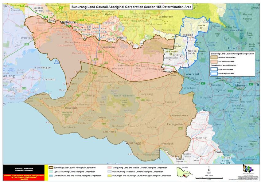
OFFICIALAttachment 1 – Map of Original Decision Area
Attachment 2 – Map of Proposal Area with GLaWAC and WTOAC areas of interest
excised
Negotiation Area Map
Proposed s155 variation boundary
negotiation area
Wadawurrung area of interest
limit of Wadawurrung area of interest
Gunaikurnai area of interest
inside negotiation area
outside negotiation area
S155 Determination
Bunurong Land Council Aboriginal Corporation
Gunaikurnai Land and Waters Aboriginal Corporation
Wadawurrung Traditional Owners Aboriginal Corporation
Wurundjeri Woi Wurrung Cultural Heritage Aboriginal Corporation
Victoria
±
VICGRID
GDA 94
Melbourne
Produced for the Victorian Aboriginal Heritage Council Taungurung Land and Waters Council Aboriginal Corporation Scale 1:375,000
This public ation may be of assistance to you but the State of Victoria and its employees
by First Peoples - State Relations 7.5 3.75 0 7.5 do not guarantee that the public ation is without f law of any kind or is wholly appropriate
for your particular purposes and therefore disclaims all liability for any error, loss or other
consequence whic h may arise from y ou relying on any information in this publication.
May 2021 kilometres K:\ GIS\ projects\Regis tered Aboriginal Parties\ VAHC Meeting May 2021\Negotiation Package\WTOAC Map-wv-27MAY21.mxd
15
OFFICIALAttachment 3 – Map Extent of Council Determination of BLCAC Country
16
OFFICIALYou can also read