National Aerial Operations Plan 2022 - OSPRI
←
→
Page content transcription
If your browser does not render page correctly, please read the page content below
National
Aerial Operations
Plan 2022
This document outlines proposed TBfree aerial
possum control operations in 2022.
OSPRI, which manages the TBfree programme, is seeking
feedback from people and organisations who may be affected
by the proposed aerial disease control operations, including
landowners and land users, farmers, hunters, and people
involved in outdoor recreation.

Details about how to provide feedback are on the
back cover, page 34. For further information, go to
www.ospri.co.nz/have-your-say.

              TBfree is an OSPRI programme            ospri.co.nz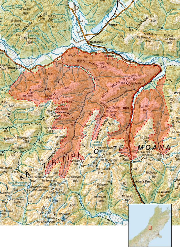
2   National Aerial Operations 2022

Contents

The TBfree programme                                                  5
     The road to TB eradication                                       6

     The TBfree programme                                             6

     Using 1080 for possum control                                    7

     How we find and control the TB infection cycle                   7

     Case study: United front stops TB spread in the Tasman region    8

     Case study: Putting the precision into bait trials               9

     Proposed aerial operations for 2022                             10

     Regional overviews                                              12

     Feedback from communities                                       12

     Opportunities for feedback                                      12

     Operations ahead                                                12

North Island Aerial Operations 2022                                  13
     Hawke’s Bay                                                     14
     Tutaekuri Mohaka/Gorge Stream (Tutaekuri Mohaka)
     – Tutaekuri-Waitara                                             14

     Ngaruroro (Tutaekuri) – Timahanga                               15

     Waipunga                                                        16

     Central North Island                                            17
     Hatepe 3 – Taupō/Waikato                                        17

     Kaipo – Hatepe Kaimanawa                                        18

     Tongariro North – Turangi, Waipakihi, Mangatepopo               19

     Lower North Island                                              20
     Aorangi – South East Wairarapa/Wellington                       20

     Southern Remutaka – Remutaka Hutt                               21
National Aerial Operations 2022    3

South Island Aerial Operations                                                     22
   Upper South Island                                                              23
   South Westland Alps                                                             23

   Otira/Taipo                                                                     24

   Central Clarence                                                                25

   Acheron East/Clarence Reserve South                                             26

   Southern Paparoa Range                                                          27

   Hochstetter                                                                     28

   Rainbow                                                                         29

   Lower South Island                                                              30
   Mount Allan                                                                     30

   Towards eradication: regional operational focus                                 32

Have your say                                                                      34
4 National Aerial Operations 2022
National Aerial Operations 2022   5

 The TBfree
programme
6    National Aerial Operations 2022

    The TBfree programme
    Possums are the wildlife source of     These objectives require             As the TBfree programme
    TB infection in cattle and deer in     maintaining very low possum          progresses towards the
    New Zealand, so possum control         numbers for significant periods      eradication of TB from wildlife
    is a key activity for the TBfree       of time through possum control.      and livestock, possum control
    programme, alongside livestock         Most possum control work             methods are constantly assessed
    TB testing and movement control.       (more than 90%) is ground-           and reprioritised to ensure the
                                           based. In some areas, aerial         best use of resources will achieve
    The TBfree programme aims
                                           1080 operations are more cost-       eradication goals.
    to achieve the following:
                                           effective than other control
    • livestock is free of TB by 2026,     methods and more efficient
                                           or the only effective method
    • possums are free of TB
                                           available.
      by 2040

    • TB is eradicated from
      New Zealand by 2050.

    The road to TB eradication
    OSPRI’s operations are time-limited. First, the possum population
    is reduced to low numbers, sometimes through an aerial operation.
    It is then maintained at a low level over several years to break the
    disease cycle.

    After control operations, checks are made to see if any TB can still
    be found in wildlife. If there is none, the area is declared TB free.

                                                                                                           TB
        Testing             Possum control,          Keeping possum                 Testing                   TB
        wildlife               year one               numbers low                   wildlife              eradicated
    Wildlife is checked    Possums spread TB.       It’s really important to   Wildlife is checked      There is no need
  to see if TB is present  Getting numbers low      keep possum numbers         for signs of TB.       for further control
 in an area. We also use    will help stop TB.     low over multiple years                            although checks are
records of herd infection.                          to break the TB cycle.                              still made for TB.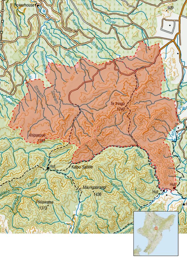
National Aerial Operations 2022       7

       Using 1080 for possum control
       The careful use of biodegradable       to control possums over large        How we use 1080
       1080 to control possums has            areas of land or forest, or where
       been a key tool in significantly       the terrain makes access on foot     Aerial application of 1080 is the
       reducing TB in cattle and              difficult or inefficient.            most effective and cost-efficient
       deer herds.                                                                 method for controlling introduced
                                              Conservation and farming leaders     possums and other predators
       Sodium fluoroacetate (1080)            have voiced strong support for       such as rats and stoats over large
       is one of the most widely              the continued use of 1080 in         areas with difficult access. 1080 is
       researched pest control tools.         New Zealand.                         the only toxin registered for aerial
       There have been extensive                                                   application that ensures possum
       investigations into its use            Success to date                      numbers are kept low enough to
       in New Zealand by both the                                                  eradicate TB.
                                              TB eradicated from more than
       Environmental Protection
                                              two million hectares.
       Agency and the Parliamentary
       Commissioner for the                   Infected herds reduced to 41 as
       Environment.                           at 30 June 2021 (down from 695
                                              in 2000).
       It has proven particularly effective
       in aerial baiting programmes

How we find and control the TB infection cycle
The red line tracks the path of
TB infection within the possum                    TB
population, circulating and
infecting maintenance hosts,                                                                     Pigs, ferrets and
with a weak link between ferrets                                                                 sometimes deer get
and livestock.                                                                                   TB from possums but
                                                                                                 not from each other.

  Possum control breaks
  the disease cycle in
  possums and stops them
  from infecting farmed
  cattle/deer.

                                                                                                 Surveys of pigs,
Possums can maintain TB within                                                                   ferrets and deer help
their own population and cause                                                                   tell us where TB is still
about 50% of herd infection cases.                                                               present in possums.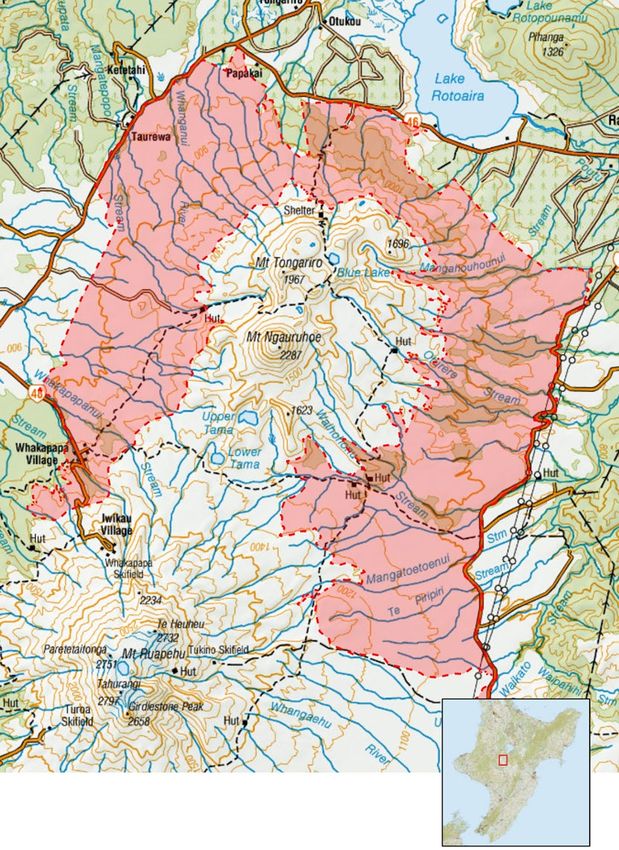
8    National Aerial Operations 2022

    Case study

United front stops
TB spread in the
Tasman region
                                       Beef and sheep
When TB spread from
                                       farmer Roy
the West Coast through                 Bensemann
the Kahurangi National                 remembers the
                                       engagement and
Park it started infecting              support from DOC
cattle and deer herds                  and their local partner Motueka
in the Motueka River                   Conservation Group – Friends of
                                                                            The large buffer
                                       Flora – being pivotal towards the
Valley. Local farmers                  delivery of the pest control.
                                                                            zones, encompassing multiple
                                                                            catchments, also had a positive
Roy Bensemann and

                                          “
                                                                            spin-off for restoring native
Phil Riley were involved                      We had a great                birdlife and flora across the
in the response and                      relationship with the              region. It complemented OSPRI
                                                                            ‘s collaborative effort with DOC,
recall the effort to quell                 local DOC office.                and paid dividends for Nelson
the TB outbreak.                          There was a mutual                farmers and local conservation
                                                                            enthusiasts alike.
                                          understanding and
The battle to prevent TB spreading                                          As a result of successful possum
                                           desire to get the
throughout the Nelson region                                                control in the Nelson region,
prompted an intensive and                 possums and other                 TB infection in cattle or deer
targeted possum control                  vector under control               herds has been confined to

                                                                  ”
operation managed by OSPRI,                                                 occasional traces related to
the Department of Conservation
                                        to halt the spread.                 animal movements from the
(DOC) and a Motueka                                                         West Coast, or wild pigs
                                       OSPRI also worked closely with
Conservation Group.                                                         discovered in the bush.
                                       local recreational pig hunters
A containment strategy was             to build awareness around            Still, you can never discount the
implemented with buffer controls       identifying suspected TB lesions     threat of TB says Mr Bensemann,
extending into the Kahurangi           found in wild pigs. This helped      “We’re always learning about this
National Park and private land         the pest control planning where      disease. You ignore TB at your
to protect about 1600 cattle and       the discovery of pigs with TB        peril, it can come from leftfield
deer herds.                            guided pest control contractors      and turn your world upside down.”
                                       on specific areas to target
Dairy farmer Phil Riley endured
                                       possum control.
four years of TB infection on
his farm. He said the focus on         Mr Riley says, “We were definitely
possum control was critical.           lucky that DOC got involved.
                                       It so happens they were rolling
Where the terrain was rugged
                                       out their biodiversity programme
and inaccessible, OSPRI
                                       Battle for our Birds and being
responded using aerial
                                       able to share funding and
1080 drops over Kahurangi
                                       resources was key.”
National Park.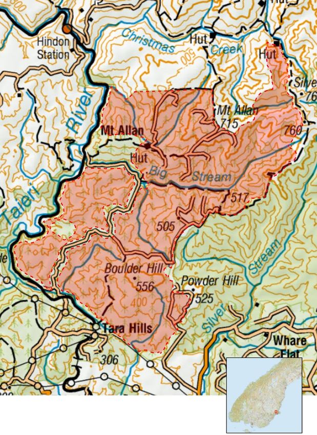
National Aerial Operations 2022 9
Case study
Putting the
precision into
bait trials
“There are great
We have moved to
opportunities
a regional model for our TBfree
which provides strong programme as we get
closer to eradicating this
regional leadership disease. The methods being
while maintaining a trialled are focused on achieving
national focus. This new aerial precision baiting,”
says Tess.
model provides a great
“
“Drone technology can resolve
opportunity for regional It’s super exciting to a lot of operational challenges,
reduce costs, and environmental
partners to connect and see how this could have impacts. For example, they can
engage with farmers a positive impact on fly closer to buffer zones around
in the area. streams, it is difficult to do an
gaining land access for
”
aerial operation with a helicopter
aerial control. without leaving a huge berth
Hawke’s Bay Regional Partners
on either side of the stream.”
Tessa Appleby and Rhea McColl,
Rhea said she was impressed
alongside Envico Technologies
with how the drone manoeuvred
(ECT) Tauranga were involved
so precisely, halting at GPS map
in testing the first flight portion
boundaries, and recording the
of precision baiting trials in
point where the bait hopper
Hawke’s Bay.
became empty and preventing
This is a key development for spread into unwanted areas.
OSPRI’s Research Programme
“It’s well suited to the terrain and
and our investment in developing
would be very efficient in areas
new and innovative ways of
with limited landing space.”
conducting aerial operations.
OSPRI Research Manager Richard
Drone technology for possum
Curtis also welcomed the results.
control offers an alternative
approach to reaching remote “It’s been consistently
and inaccessible areas harbouring encouraging. The hypothetical
infected possums. question we proposed was,
‘Is there an application for drones
Tess and Rhea, who work closely
in our operations? Can we use
with Hawke’s Bay farmers
drones in small areas where you
described the opportunity to be
can drop bait precisely? I also
part of the OSPRI Research and
wanted to know if it was possible
ECT trial as a thrilling experience.
to use thermal imaging for
possum surveillance.”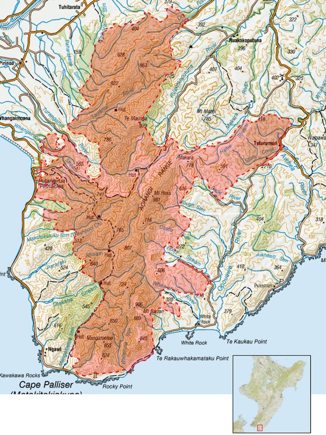
10   National Aerial Operations 2022

Proposed aerial operations for 2022
These maps outline the aerial          Aerial operations cover about 10%   Specific details and operational
disease control activities             of proposed operational activity.   boundaries are indicative
proposed for 2022. Each region                                             only and may change as a
                                       The majority of the remaining
has a different disease control                                            result of further planning and
                                       work involves wildlife surveys
focus based on the status of                                               feedback. Final details will
                                       (50%) and ground-based pest
infected herds and wildlife,                                               be communicated directly to
                                       control making up the balance
explained on page 12.                                                      affected parties, and through
                                       (40%). For detail on the specific
                                                                           letters, public notifications,
                                       aerial operations proposed,
                                                                           media and at ospri.co.nz.
                                       please refer to the page numbers
                                       in the table of contents.
National Aerial Operations 2022 11 Control operations area coverage 2021 Proposed activity North Island Upper South Island Lower South Island Aerial operations 155,125ha 210,205ha 3,857ha
12   National Aerial Operations 2022

Regional                               control work. Ground-based
                                       possum control will continue
                                                                            OSPRI makes informed decisions
                                                                            by assessing feedback about the
overviews                              in many West Coast valleys to        parameters of the operations,
                                       protect herds from infection.        not the methodology or the
                                                                            use of 1080. While OSPRI is not
North Island                           In the North Canterbury-
                                                                            responsible for regulation of
                                       Marlborough high country, aerial
In the North Island, we are                                                 1080 all its operations are subject
                                       operations are proposed under
working on continuing the                                                   to regulations administered by
                                       long-term plans to eradicate
extensive possum control effort                                             the Environmental Protection
                                       infection from herds in Clarence
that has been occurring since                                               Agency (EPA).
                                       Valley and on Molesworth Station.
the increase of livestock TB
cases observed in Hawke’s Bay
in April 2019. We are also
                                       A successful possum control
                                       operation took place in the
                                                                            Opportunities
continuing important work              winter of 2021 across parts of       for feedback
in the Central and Southern            Molesworth Station, including
North Island to protect herds.         a great effort towards mitigating    As manager of the TBfree
                                       unintended deer by-kill. OSPRI       programme, OSPRI is keen
The work in the Hawke’s Bay
                                       propose to treat Acheron East        to listen to the views of all
includes proposed aerial 1080
                                       and parts of the Clarence Valley     communities interested in the
operations around Tutaekuri and
                                       in 2022 in order to continue this    proposed aerial programme
Waipunga to re-establish buffer
                                       work towards decreasing possum       across New Zealand. The areas
zones and address high density
                                       populations in North Canterbury-     of operation are detailed in the
possum areas.
                                       Marlborough.                         next section of this document,
Elsewhere in the North Island,                                              and input is encouraged via
combined aerial and ground-            Lower South Island                   the form at the back of this
based possum control operations                                             document.
                                       The sole aerial operation proposed
are proposed for South East
                                       for 2022 in the Lower South
Wairarapa, within and about
                                       Island is the Mount Allan aerial
the Southern Remutaka Ranges,
                                       in Mount Hyde TB Management
Hatepe to the east of Lake
                                       Area (TMA). While historically
Taupō, Kaipo block in Kaimanawa
                                       this TMA had infected herds
Forest Park and Tongoriro North
                                       throughout, in more recent times
surrounding Mt Ngauruhoe.
                                       both ground and aerial control
By working with our stakeholders       has suppressed infections.
we have mutually beneficial            However, TB infected wildlife
outcomes such as controlling           have been found in the
possums for TB eradication and         neighbouring Mount Cargill and
supporting the biodiversity efforts    East Otago TMAs in 2016 and
of the Aorangi range project.          2020. In addition, Mount Cargill
                                       TMA had herd breakdowns
Upper South Island                     during 2015 and 2016.
On the West Coast, aerial control
is proposed for South Westland         Feedback from
Alps near Hari Hari and will
complement the One One and             communities
Ianthe aerials completed in 2021.
                                       This summary of OSPRI’s
Very high possum densities have
                                       proposed aerial pest management
been recorded in Hari Hari,
                                       programme for 2022 has been
with recent nearby herd infection
                                       prepared to give interested and
cases. The West Coast divide
                                       affected parties an opportunity
is also proposed for aerial
                                       to provide feedback about the
control with the Otira, Taipo, and
                                       parameters of the operations,
Hochstetter areas coming up for
                                       such as the possibility of using
treatment. Finally, the Southern
                                       deer repellent, boundaries and
Paparoa Range aerial operation
                                       the timing of the operation from
will reduce herd infection risks
                                       a seasonal perspective.
in the lower Grey Valley and will
complement nearby Department
of Conservation (DOC) aerial
National Aerial Operations 2022 13
North Island
Aerial Operations
202214 National Aerial Operations 2022
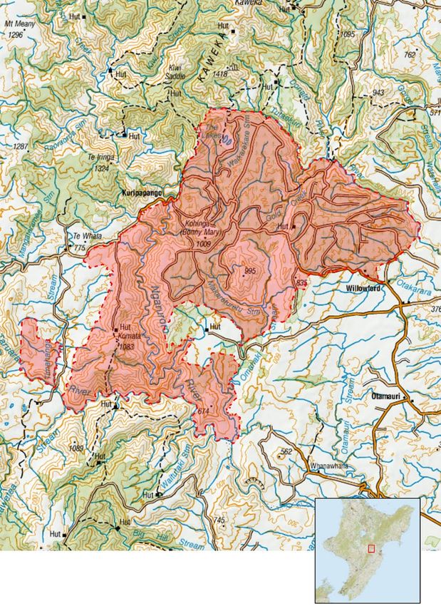
Hawke’s Bay
Tutaekuri
Mohaka/Gorge
Stream (Tutaekuri
Mohaka)
Tutaekuri-Waitara
Terrain and operational area
This operational area has the
Mohaka River and Mangatutu Hot
Springs on its northern boundary.
Its eastern boundary follows
farmland south to Whittle Rd and
travels west to Little’s Clearing,
extending north to connect back
to the Mohaka River. The area is
entirely public conservation land
and generally very steep country,
with hunting of sika and red deer.
The Gorge Stream component of
the operation runs along the east
boundary of Kaweka Forest park
down to Kaweka flats.
TB management area
The area is part of the Tutaekuri-
Waitara TMA. However the
Gorge Stream component sits
in the Kaweka TMA.
Consultation and
collaboration
This operation was recently
added as part of the Hawke’s Recent TB infection history Operational control
Bay response and OSPRI is
This operation forms part method preferred
collaborating with both DOC, iwi
and hunting interest groups to of the Hawke’s Bay response Thorough coverage throughout
see the success of this operation. programme and is required the block is required to ensure
to re-establish the buffer zone a high level of confidence of
to prevent known infection TB freedom. The large area and
from forest land spreading its dense bush habitat makes
to neighbouring farms. ground access virtually impossible
in some areas, meaning aerial
control is essential.
Map boundaries are indicative only and are subject to change after consultation.
NZ Tyopographic Series Maps sourced from the LINZ Data Service and licensed by
LINZ for re-use under the Creative Commons Attribution 3.0 New Zealand license.National Aerial Operations 2022 15
Ngaruroro
(Tutaekuri)
Timahanga
Terrain and operational area
The Tutaekuri aerial project in
Hawke’s Bay is adjacent to the
southern end of the Kaweka
Range and north of the Ruahine
Range. The cover is a mix of
regenerating scrub, native forest
and exotic forestry.
TB management area
The Ngaruroro operation is part
of the Timahanga TMA.
Consultation and
collaboration
Consultation for this operation
will be in conjunction with DOC
and landowners within the
proposed area.
Recent TB infection history
An infected herd was identified
in the area. DNA typing has
indicated that it is a local
Central North Island strain
of TB. This strain was also
found in deer in the Comet
and Sparrowhawk areas.
Operational control
method preferred
This area has a vegetation type
and topograph that suits aerial
control as a TB control method.
Fast and effective control of
possums to low numbers will give
more certainty around reduction
and eradication of TB in this area.
Map boundaries are indicative only and are subject to change after consultation.
NZ Tyopographic Series Maps sourced from the LINZ Data Service and licensed by
LINZ for re-use under the Creative Commons Attribution 3.0 New Zealand license.16 National Aerial Operations 2022
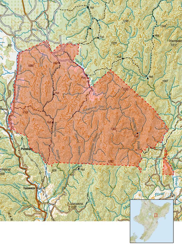
Waipunga
Terrain and operational area
The Waipunga operation covers
36,900ha of Crown, private, and
iwi trust-owned land. The project
area is approximately 80km north
of Napier in the vast wilderness
making up the southern end of
the Whirinaki Forest Park, and
abuts the southern boundary
of Te Urewera. The terrain is
moderate to very steep native
bush, predominantly covered
in thick indigenous bush and
commercial forestry, with a
small amount of farmland. Major
waterways within and bordering
the project area include the
Mohaka, Waipunga, Te Hoe,
Hautapu and Mokomokonui rivers.
The area is remote, with some
hunting and dog use, especially
near northern and western
boundaries with Kaingaroa
Forest. Private land within the
area is regularly controlled for
biodiversity purposes and, as
a result, has large numbers
of kiwi and other threatened
fauna. The area also has actively
protected sites of the native
trees Pittosporum turneri
and kākābeak.
TB management area of this area. 42% of the area is Operational control
DOC public conservation land method preferred
This operation is in the Waipunga therefore OSPRI will be working
TMA. This operation connects closely with both landowners, The area is very steep in places
on its northern and western DOC and affected iwi throughout and while some areas are tracked,
boundaries with two operations the consultation phase of large sections of the northern
completed in 2017 – Wheao the operation. areas have steep terrain and
(OSPRI) and Whirinaki (DOC). thick vegetation which hamper
While the Waipunga operation is Recent TB infection history ground access. Some ground
primarily aimed at TB eradication control is carried out by private
it will add significantly to the Infected pigs were found on landowners, but only in limited
biodiversity gains achieved from adjacent land, indicating that areas with good foot access.
these other recent operations. wildlife was infected with TB. Aerial 1080 baiting is required
Some private landowners are Possum surveys have also shown to ensure effective overall control.
doing considerable biodiversity density levels that are very high.
work and welcome the additional It is therefore important that
control. this operation occurs to ensure
there is no remaining TB in
Consultation and wildlife that may reinfect farmed
collaboration cattle and deer.
This operation requires
consultation with the private
landowners that hold the majority
Map boundaries are indicative only and are subject to change after consultation.
NZ Tyopographic Series Maps sourced from the LINZ Data Service and licensed by
LINZ for re-use under the Creative Commons Attribution 3.0 New Zealand license.National Aerial Operations 2022 17
Central North Island
Hatepe 3
Taupō/Waikato
Terrain and operational area
Hatepe 3 is primarily production
pine forest. The topography is
flat-to-moderate hill country, with
steep native bush gorges. Lake
Taupō Forest Trust administers
most of the pine forest within
the operational boundary. The
Hinemaiaia River, on the northern
edge of the area’s boundary, is a
popular fishing location and the
wider area is used for recreational
hunting of wild pigs and deer.
TB management area
The area is part of the Hatepe
Lake TMA.
Consultation and
collaboration
Preliminary discussions have
been held with DOC regarding
public land requirements.
Local beneficial trust owners
were initially consulted in 2019.
Discussions will continue with the
board of Lake Taupō Forest Trust.
Recent TB infection history
The area has an extensive history Operational control
of TB infection in the wildlife method preferred
population. Infected possums
The rugged nature of the terrain,
were found at Motuoapa in 2010
dense bush habitat, size and
and 2012. In June 2020, a possum
general inaccessibility of this
showing TB-typical lesions was
block, means aerial control
recovered from the area.
is the preferred and most
effective method.
Map boundaries are indicative only and are subject to change after consultation.
NZ Tyopographic Series Maps sourced from the LINZ Data Service and licensed by
LINZ for re-use under the Creative Commons Attribution 3.0 New Zealand license.18 National Aerial Operations 2022
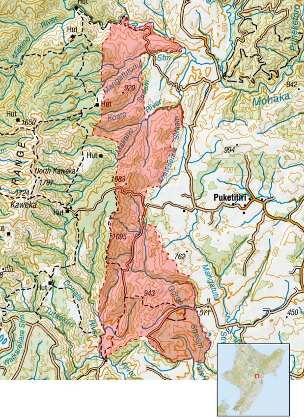
Kaipo
Hatepe Kaimanawa
Terrain and operational area
This control area is situated within
Kaimanawa Forest Park. The
area lies to the south-east of the
Taupō township and extends from
the Hinemaiaia Stream in the west
and extends to and reaches parts
of the Taharua River in the east.
The area contains a mixture of
steep to very steep native forest,
which is mostly unmodified red
beech with a thick understory
of pepperwood and other native
species. Most of the area is DOC
managed Public Conservation
Land. There are several huts
regularly used by hunters and
trampers throughout the year.
TB management area
The Kaipo operation is part of
the Hatepe-Kaimanawa TMA.
Consultation and
collaboration
OSPRI collaborated with Manaaki
Whenua Landcare Research
(MWLR) and DOC to undertake
deer repellent trials in this area
during the last aerial operation
in 2016.
Recent TB infection history
Operational control
TB has been found regularly in method preferred
wildlife in the area. A possum
monitoring operation in the area The area is covered in native bush
in June 2019 indicated a high on steep and moderate country,
possum population. making aerial 1080 control a more
cost-effective and safe option over
sometimes dangerous ground.
Map boundaries are indicative only and are subject to change after consultation.
NZ Tyopographic Series Maps sourced from the LINZ Data Service and licensed by
LINZ for re-use under the Creative Commons Attribution 3.0 New Zealand license.National Aerial Operations 2022 19
Tongariro North
Turangi, Waipakihi,
Mangatepopo
Terrain and operational area
This area consists of a range of
native vegetation over varied
altitudes and it includes flat
areas through to steep areas that
reach up to the snowline. There
is a mixture of beech forest,
kānuka, alpine tussock and low
scrub which covers a majority of
the proposed area. There is also
a significant amount of exotic
forest in the treatment area that
is privately owned. Part of the
area includes Tongariro National
Park and the frequently used
Tongariro crossing.
TB management area
The planned operational areas
fall within three TMAs; Turangi,
Waipakihi and Mangatepopo.
The operation aims to remove
possums from this area to stop
the transmission of TB through
the area from the east where it
could travel back into areas that
are currently free of TB.
Consultation and
collaboration
Since there is a large portion
River and another near the
of DOC land, both DOC and
headwaters of the Waiotaka
iwi will be consulted over
Stream in 2015.
the effects of this operation.
Other significant landowners
Operational control
include forestry trust and some
method preferred
private land.
The wide range of vegetation
Recent TB infection history types makes ground control
There has been limited infection less effective and, in some parts
inside this area in recent times. of the area, an unsafe method
The closest TB came to the area of control. Aerial control is the
was through two pigs north east preferred and more effective
of this area; one in 2014 in the control method.
headwaters of the Waimarino
Map boundaries are indicative only and are subject to change after consultation.
NZ Tyopographic Series Maps sourced from the LINZ Data Service and licensed by
LINZ for re-use under the Creative Commons Attribution 3.0 New Zealand license.20 National Aerial Operations 2022
Lower North Island
Aorangi
South East
Wairarapa/
Wellington
Terrain and operational area
The Aorangi aerial project is
situated in the very south-eastern
corner of the Wellington Region,
within the South Wairarapa
District. The Aorangi Range
(formerly known as the Haurangi
Range) extends more than
20 kilometres north from Cape
Palliser, and is the southernmost
mountain range on the island.
The greater portion of these
mountains are covered in native
forest which is protected and set
aside for public recreational use
as part of the Aorangi Forest Park.
The Putangirua Pinnacles are
located near the western edge
of the ranges.
TB management area
Aorangi aerial operation is within
the South-East Wairarapa TMA.
The 2021–22 aerial operation
is the last one planned in this
area to control TB in the wildlife.
Consultation and
collaboration to possum control using a range Operational control
This proposed aerial operation of techniques to monitor wildlife method preferred
in the Aorangi area is the third of species within the area.
The large area, and dense
a collaborative project involving
Recent TB infection history bush habitat, makes ground
OSPRI, Greater Wellington
access challenging and virtually
Regional Council (GWRC), The South-East Wairarapa TMA impossible in some areas,
DOC and the Aorangi Restoration has a long history of TB, in wildlife meaning aerial control is the
Trust. Victoria University of and cattle herds. In 2010–11 preferred method.
Wellington is conducting a infected herds were identified
10-year monitoring study as To help reduce deer by-kill,
close to the Aorangi Range.
part of the collaborative project, we intend to use deer repellent
The most recent wildlife infection
for this operation, subject to
looking at biodiversity responses was found in a young pig in 2016.
consultation.
Map boundaries are indicative only and are subject to change after consultation.
NZ Tyopographic Series Maps sourced from the LINZ Data Service and licensed by
LINZ for re-use under the Creative Commons Attribution 3.0 New Zealand license.National Aerial Operations 2022 21
Southern
Remutaka
Remutaka-Hutt
Terrain and operational area
Located at the southern end of
the Remutaka Range, the area
surrounds the Orongorongo
River, with a steep-sided gorge
extending north towards
Wainuiomata. Native forest and
scrub are the primary habitat
types. Ownership is a mix of
multiple private owners and
the Remutaka Forest Park that
is managed by DOC.
TB management area
The area is part of the Remutaka-
Hutt TMA.
Consultation and
collaboration
OSPRI has been working with
DOC, Greater Wellington Regional
Council, and conservation groups
working in the area to coordinate
control operations.
Recent TB infection history
This area has a long history of TB
in the wildlife. Infected possums
and pigs have been captured as
recently as 2011. The last time
the area was aerially controlled
was 2017.
Operational control
method preferred
The large area, and dense
bush habitat, makes ground
access challenging and virtually
impossible in some areas,
meaning aerial control is the
preferred method.
To help reduce deer by-kill,
we intend to use deer repellent
for this operation, subject to
consultation.
Map boundaries are indicative only and are subject to change after consultation.
NZ Tyopographic Series Maps sourced from the LINZ Data Service and licensed by
LINZ for re-use under the Creative Commons Attribution 3.0 New Zealand license.22 National Aerial Operations 2022 South Island Aerial Operations Map boundaries are indicative only and are subject to change after consultation. NZ Tyopographic Series Maps sourced from the LINZ Data Service and licensed by LINZ for re-use under the Creative Commons Attribution 3.0 New Zealand license.
National Aerial Operations 2022          23

Upper South Island

South
Westland Alps
Terrain and operational area
The three operational areas
chosen to be completed as one
project in 2022 consist of the
Upper Wanganui, Wilburg Range
and Upper Waitaha. These are
the aerial blocks which border
the Hari Hari TMA. The blocks
are interspersed with high alpine
altitude Vector Free Area (VFA).
The areas encompass the TB
hotspot that is the Wanganui
River as well as the headwaters
of the Poerua and Waitaha Rivers.
DOC huts and walking tracks
exist within the area which may
need to be excluded and then
assessed for possum presence.

TB management area
The planned operational areas
are within the South Westland
Alps TMA.

Consultation and
collaboration
OSPRI is working closely with
technical advisors at DOC to
ensure kea survival is optimised
when carrying out the South
Westland Alps possum control
operation. OSPRI is collaborating   Recent TB infection history               Operational control
with Manaaki Whenua Landcare
                                    Infected possums have been                method preferred
Research (MWLR), DOC and
the Kea Conservation Trust to       found up the Wanganui River               While most of the highest altitude
implement kea mitigation and        as recently as 2021 and infected          country has been ruled out based
undertake bait aversion training    deer were identified in 2018.             on habitat, the remaining area
with local kea. The aversion        Evidence suggests the South               is steep and rugged. With TB
method was developed by ZIP,        Westland Alps are the source              proven to be present in the area
                                    of infection for herds within the         it is imperative that complete
and trialled successfully in the
                                    Hari Hari TMA. To prevent further         coverage is achieved through at
nearby Perth River Valley pest
                                    herd infection in the Hari Hari           least two rounds of control. Aerial
operations. More information
                                    and Waitaha farmlands, the                treatment is considered the most
can be found on the ZIP website
                                    source of disease must be treated         effective way to break the disease
– www.zip.org.nz
                                    as soon as possible.                      cycle in wildlife and achieve
                                                                              eradication by 2035.

                                        Map boundaries are indicative only and are subject to change after consultation.
                                       NZ Tyopographic Series Maps sourced from the LINZ Data Service and licensed by
                                       LINZ for re-use under the Creative Commons Attribution 3.0 New Zealand license.
24 National Aerial Operations 2022
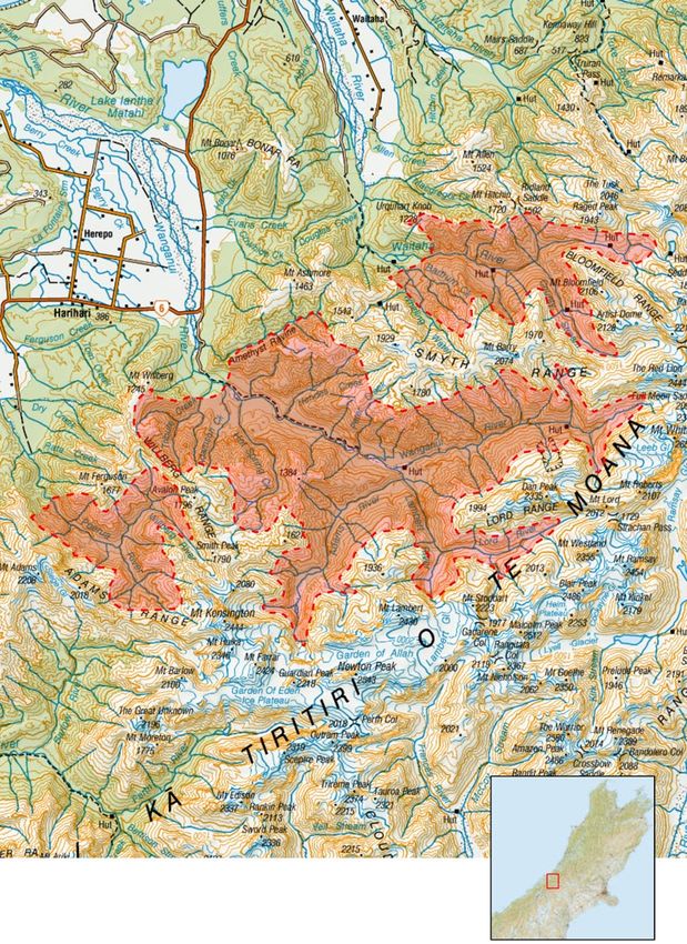
Otira/Taipo
Terrain and operational area
The Otira/Taipo block is located
along the south bank of the
Taramakau Valley 19km east
of Kumara Township from the
Big Wainihinihi Creek through
to Aickens. This operation
incorporates the Griffen, Tara
Tama, Bald, Barron, Campbell
and Kelly Mountain ranges.
The operational area is split
by the Taipo and Otira Rivers.
The area is comprised of steep
slopes, creeks and ridge systems
rising to levels of over 1,100m.
The bush cover is mainly
podocarp in the lower section
merging into native beech in
the upper areas. The northern
boundary is the Taramakau River,
and the southern boundary is
the high alpine area of the
southern divide.
TB management area
The planned operational areas
fall within three TMAs; Westland,
West Coast Divide and the South
Westland Alps.
Consultation and
collaboration
OSPRI is working closely with
technical advisors at DOC to
ensure kea survival is optimised
Recent TB infection history numbers have recovered since
the previous aerial through
when carrying out the South The Taramakau Valley has been
Westland Alps possum control the Taramakau Valley in 2016.
a historical TB hotspot for many
operation. OSPRI is collaborating The ground block has failed
years with TB possums found
with MWLR, DOC and the Kea performance measures twice
through the valley and as far up
Conservation Trust to implement in the past 24 months recording
as Harper Pass within the last
kea mitigation and undertake Bit Mark Index (BMI) in excess
five years. Recent infection in
bait aversion training with local of 45%. A 2018 information
Inchbonnie is thought to have
kea. The aversion method was monitor in the Taipo aerial block
stemmed from the Taramakau,
developed by ZIP and trialled returned a BMI of 23%. With
Taipo and/or Otira Rivers making
successfully in the nearby Perth high possum numbers and
aerial control imperative for
River Valley pest operations. More proven TB in the wildlife, aerial
herd protection. The planned
information can be found on the 1080 is the quickest and most
ZIP website – www.zip.org.nz aerials will protect the herds
cost-effective option to reduce
downstream by cutting off the
DOC have plans to treat the this possum population rapidly
potential source of infection.
surrounding area in 2022 and to protect the herds downstream
OSPRI is working closely with from further infection.
Operational control
DOC to link timings to maximise method preferred
efficiencies.
Recent performance monitors
of the adjoining ground control
exclusions suggest that possum
Map boundaries are indicative only and are subject to change after consultation.
NZ Tyopographic Series Maps sourced from the LINZ Data Service and licensed by
LINZ for re-use under the Creative Commons Attribution 3.0 New Zealand license.National Aerial Operations 2022 25
Central Clarence
Terrain and operational area
The Central Clarence area
lies within Muzzle Station.
It encompasses Haycock Saddle
with Dart Stream meeting the
Clarence River at the northern
boundary and Fidget Spur
making up the southern boundary
TB management area
The planned operational area is
within the Clarence Reserve TMA.
Consultation and
collaboration
Central Clarence is in the
Clarence Valley and forms part
of Muzzle Station where there
has been an extensive effort to
eradicate TB. There has been
early notification of this operation
to local iwi. OSPRI has chosen
to use deer repellent and a lower
sowing rate after a recent trial
using this methodology in
similar habitat.
Recent TB infection history
Central Clarence was originally
home to one of the longest
standing infected herds on the
East Coast. While currently sitting
under a clear herd status, the
control plan must continue to Operational control
ensure the disease cycle in the
method preferred
residual possums population is
broken and the density kept low This aerial operation provides
to mitigate the risk of potential further protection from the
re-infection of diseased wildlife adjacent Clarence Reserve aerial
migrating from Molesworth via completed in 2018. Rugged,
the Clarence River, which could isolated and dangerous to access
act as a possible disease conduit. in most parts by foot, aerial
control of the area is considered
the most viable and effective way
to achieve eradication.
Map boundaries are indicative only and are subject to change after consultation.
NZ Tyopographic Series Maps sourced from the LINZ Data Service and licensed by
LINZ for re-use under the Creative Commons Attribution 3.0 New Zealand license.26 National Aerial Operations 2022
Acheron East/
Clarence Reserve
South
Terrain and operational area
In 2022, Acheron East operations
will be combined with the
southern section of the Clarence
Reserve including Cloudy Range.
The Acheron East block
encompasses the area between
the Acheron River and Clarence
River including Lake McRae and
the Guide River. The western
boundary extends slightly west
of the Acheron River to the
Yarra and moves north towards
Mt Augarde with Rachel Range
and Turks Head making up the
northern boundary. The Clarence
River forms the southernmost
boundary. Major waterways
include Half Moon Stream and
the Dillon River.
The Clarence Reserve south block
encompasses the northern end
of the Amuri Range and the steep
terrain between the Seaward
Kaikoura ranges and the Clarence
River. The southern boundary Deer Association local branches The Clarence Reserve TMA was
is at Mt Tinline and it runs north and other hunting groups. originally home to one of the
towards Dubious Stream.
OSPRI has been working with longest standing infected herds
The habitat type is predominantly Landcare Research and deer on the East Coast. While currently
rolling to steep terrain with repellent providers to trial the sitting under a clear herd status,
tussock, native grasses, scrub efficacy of new deer repellent the control plan must continue
and bush isolated to patches formulations as well as lower to ensure the disease cycle in
and gullies. It generally has a sowing rates. Positive results from residual possums is broken and
dry, drought-prone climate. recent deer repellent and low sow population density kept low
trials mean OSPRI may assess this to prevent potential reinfection
TB management area area for the delivery of a large- from Molesworth via the
scale application in 2022. Clarence River.
The planned operational areas
fall within three TMAs; Clarence Recent TB infection history Operational control
Reserve, Molesworth/Clarence
The Molesworth cattle herd has method preferred
Reserve and Conway Waiau.
a long history of TB infection
The operation area is vast, being
Consultation and related to wildlife. There is also
nearly 100,000ha and rugged,
collaboration the possibility that infection
isolated and dangerous to access
discovered in the Rainbow Valley
in most parts by foot. Aerial
The Molesworth Steering is linked to diseased animals
control is considered the most
Group was established in 2018, migrating from the Molesworth
viable and effective way
comprising representatives from Station area. Tackling the source
to achieve eradication.
key stakeholders and groups of infection at Molesworth will
in the area. There is on-going support TB freedom progress
engagement with New Zealand in the neighbouring TMAs.
Map boundaries are indicative only and are subject to change after consultation.
NZ Tyopographic Series Maps sourced from the LINZ Data Service and licensed by
LINZ for re-use under the Creative Commons Attribution 3.0 New Zealand license.National Aerial Operations 2022 27
Southern Paparoa
Range
Terrain and operational area
The Southern Paparoa Range
operation runs south from
the Punakaiki River to slightly
north of Rapahoe. The eastern
boundary follows the tops of the
Paparoa Range where it meets
the boundary of the neighbouring
OSPRI Atarau aerial operation
and DOCs Roaring Meg operation.
The northern edge meets DOC’s
Punakaiki treatment boundary.
TB management area
The planned operational area is
within the Southern Paparoa TMA.
Consultation and
collaboration
OSPRI’s proposed operational
area is bounded at its north-
eastern end by two DOC
operations, Punakaiki and Roaring
Meg. OSPRI has worked with
DOC to ensure boundaries meet
effectively to avoid gaps in
operational treatment.
Recent TB infection history
TB possums have been found
around the 12 Apostles Range
with wildlife determined to be
the source of infection for a the coastal flats, the potential
handful of herds in the area. source of infection from the
While infected herds have cleared Paparoa Ranges needs to be
since the 2017 operation, the controlled. Aerial 1080 is the
2022 planned aerial will further most cost-effective, safest and
reduce the possum population efficient method to achieve the
and ensure the disease cycle required level of possum control
is broken. in this TMA.
Operational control
method preferred
Due to the rugged nature of the
terrain and the inaccessibility of
this block, an aerial application
is the preferred option for
treatment. To protect herds along
Map boundaries are indicative only and are subject to change after consultation.
NZ Tyopographic Series Maps sourced from the LINZ Data Service and licensed by
LINZ for re-use under the Creative Commons Attribution 3.0 New Zealand license.28 National Aerial Operations 2022
Hochstetter
Terrain and operational area
The Hochstetter aerial is
approximately 20km south-
east of Nelson Creek and
approximately 75km east
of Greymouth.
Two rugged ridges occur in the
block extending from west to
east with the remainder of the
block undulating and flat. The
block has a history of forestry
and mining activity and areas
disturbed in the past are now
covered by significant stands
of mature gorse.
TB management area
The planned operational area is
within the West Coast Divide TMA.
Consultation and
collaboration
Hochstetter is comprised of
DOC and Ngāi Tahu forestry land.
DOC has been notified of the
planned operational area and
OSPRI is commencing discussions
with hapū. Landowners adjoining
the operation are expected
to be generally supportive of
the operation due to historic
experiences with TB and the
presence of TB possums in the
nearby Waiheke River. down the Waiheke/Ahaura rivers Aerial application ensures
and into the farmland, the high complete coverage and knocks
Recent TB infection history possum population in Hochstetter the population back to below
After TB was found in possums immediately downstream of this required levels quickly. The intent
in the Waiheke River in 2016, source area, means the risk of of control is to quickly prevent
the Ahaura catchment has been reinfection spilling out into the Hochstetter picking up residual
considered a High Risk Area for Grey Valley is high. infection from the Waiheke
TB management purposes. Due source area. Aerial 1080 is the
Operational control most cost-effective, quickest and
to the long period since control,
it is expected that possums within method preferred safest method to achieve the
the Hochstetter block will be at required level of possum control
Due to the very high possum
a level capable of sustaining TB. in this TMA.
numbers expected, aerial
While ground control is mitigating application is the preferred
the potential of infection moving option for treatment.
Map boundaries are indicative only and are subject to change after consultation.
NZ Tyopographic Series Maps sourced from the LINZ Data Service and licensed by
LINZ for re-use under the Creative Commons Attribution 3.0 New Zealand license.National Aerial Operations 2022 29
Rainbow
Terrain and operational area
The proposed Rainbow aerial
takes in the catchments and
tributaries for the Wairau and
Rainbow Rivers. The northern
boundary is expected to cease
at Dip Flat with the southernmost
boundary bordering Molesworth
Station.
TB management area
The planned operational area is
within the Wairau Waihopai TMA.
Consultation and
collaboration
OSPRI has been working with
Rainbow Station to draft an
operational plan for control and
surveillance. Control for herd
protection has commenced with
wider discussions surrounding
possible aerial control still to
be had. Local DOC staff have
been briefed on the necessity
of possum control to achieve
TB freedom objectives. OSPRI
is working closely with members
of the Kea Conservation Trust to
ensure that any future aerial control
plans include kea mitigation.
Recent TB infection history
TB was first found in ferrets at Operational control
the junction of the Rainbow and
method preferred
Wairau rivers in 2017–18. It was
hypothesised that these ferrets Due to the very high possum
were long distance migrants numbers expected, aerial
from known infection in the application is the preferred option
neighbouring Molesworth Station. for treatment. Aerial application
Following a herd infection in ensures complete coverage and
2019, possum surveillance was knocks the population back to
undertaken in 2021. The discovery below required levels. Rugged,
of TB infection in possums within steep and dangerous to access
the Rainbow Valley has spurred in almost all parts by foot, aerial
a control response with accessible control is considered the most
areas now undergoing ground viable and effective way to
control. OSPRI is working with achieve eradication in this TMA.
contractors to undertake novel
survey techniques (such as
sentinel pigs) to determine the
extent of wildlife infection.
Map boundaries are indicative only and are subject to change after consultation.
NZ Tyopographic Series Maps sourced from the LINZ Data Service and licensed by
LINZ for re-use under the Creative Commons Attribution 3.0 New Zealand license.30 National Aerial Operations 2022
Lower South Island
Mount Allan
Terrain and operational area
The only aerial operation in the
LSI to be completed during 2022
is the Mount Allan aerial within
the Mount Hyde TMA and covers
approximately 5,000ha. This
aerial block borders the East
Otago and Mount Cargill TMAs,
both of which have had recent
wildlife and in the case of
Mount Cargill, herd infections.
TB management area
The planned operational area
is within the Mount Hyde TMA.
Consultation and
collaboration
Mount Allan is comprised mainly
of private forestry land and
private landowners. Discussions
with forestry companies in the
area and adjoining land have
commenced. Further engagement
with private landowners is
planned for the future and
they and forestry companies
are expected to be generally
supportive of the operation
due to both the pest control
advantages and TB suppression
through possum control.
Recent TB infection history wildlife infection moving into this that complete coverage is
area the high levels of possum achieved through aerial control.
Historically this TMA had infected
habitat in this area must be This final aerial will also give us
herds throughout but in more
treated as soon as possible. assurance that we are reaching
recent times both ground and
Proof-of-Freedom from TB in the
aerial control has suppressed Operational control wildlife and assist towards the
infections. But TB infected
method preferred national TB eradication goals.
wildlife have been found in the
neighbouring Mount Cargill and The Mount Allan area is steep The aerial control at Mount Allan
East Otago TMAs in 2016 and and rugged, covered with deep will complement further intensive
2020. In addition, Mount Cargill gullies and not practical or safe ground control work in 2021–22
TMA had herd infections during to control by ground. With this and 2022–23.
2015 and 2016 with the last herd area covered in possum habitat
being cleared in 2020. To prevent and TB proven to be present in
further herd infections and bordering areas it is imperative
Map boundaries are indicative only and are subject to change after consultation.
NZ Tyopographic Series Maps sourced from the LINZ Data Service and licensed by
LINZ for re-use under the Creative Commons Attribution 3.0 New Zealand license.National Aerial Operations 2022 31
32    National Aerial Operations 2022

Towards eradication: regional operational focus
The TBfree programme’s                  The operations open for feedback      control activities along a
operational activities are bringing     in this document are part of a        determined path towards
many areas significantly closer         national aerial approach to TB        TB eradication, as illustrated
to planned eradication dates.           management.                           in the maps following.

                                        Regional plans for TB eradication     TB Management Areas (TMAs)
                                        are focused on remaining areas        across New Zealand are shaded
                                        with TB infection risk in wildlife.   on the maps below, with their
                                        These will be systematically          expected dates of eradication.
                                        treated with possum population

Planned eradication by:

     Planned eradication by 2025

     Planned eradication by 2030

     Planned eradication by 2035
National Aerial Operations 2022 33
Planned eradication by:
Planned eradication by 2025
Planned eradication by 2030
Planned eradication by 203534 National Aerial Operations 2022
Have your say
We invite feedback on our 2022 national plan for TBfree pest control
operations. We are seeking feedback specifically on the nature, boundaries
and timing of proposed operations.
We are not seeking feedback on wider issues such as the purposes of the TBfree programme or the use
of 1080 for pest control in New Zealand.
OSPRI encourages engagement with interested communities and those affected by proposed TBfree
operations, and invites input on this document until 26 November 2021 through several channels:
• By email to consultation@ospri.co.nz
• By post to National TBfree Operations Consultation, PO Box 3412, Wellington 6140
• By phone on 0800 482 463
• By completing the form at www.ospri.co.nz/have-your-say website.
Please use the form below to submit your feedback on any of the proposed pest control operations
outlined in this document.
Your feedback may become publicly available information. For this reason, please indicate clearly if your
comments are commercially sensitive or if, for some other reason, you do not consider that they should be
disclosed. Any request for non-disclosure will be considered under the Official Information Act 1982 and
the Privacy Act 1993.
Your feedback will be used to help inform the final proposals.
Thank you.
Name
Position and organisation
Area of interest (farmer, hunter, etc)
Phone
Email
Postal address
1. What is the proposed aerial operation/s you are commenting on?
2. What is the primary subject of your feedback?
Timings of proposed operation Other (please state):
Boundaries
Impact on business or commercial activity
General operational concerns
3. Please outline your feedbackYou can also read