RP57N02W201800A - Bonner County
←
→
Page content transcription
If your browser does not render page correctly, please read the page content below
Tom Duebendorfer (208) 290-5992
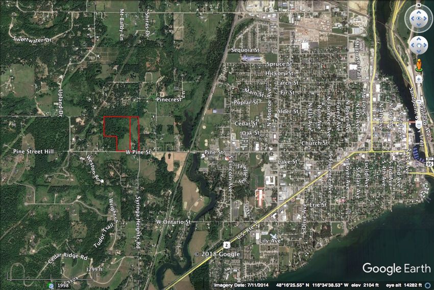
Wetland Delineation: 10404 West Pine Street, Sandpoint, ID
2
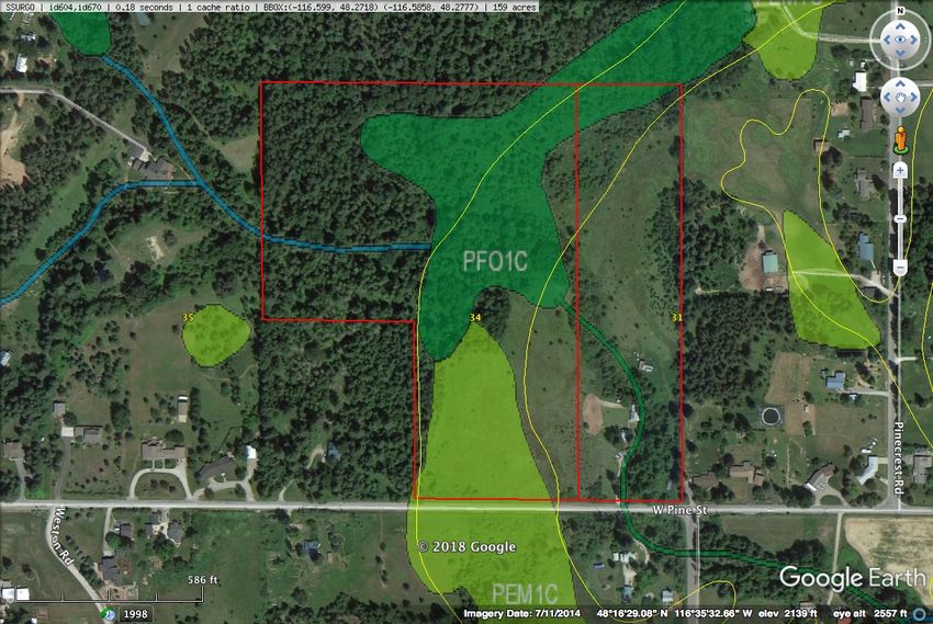
RP57N02W201951A RP57N02W201800A Figure 1
23 acres 10 acres Vicinity Map
Elan Hazan
Township 57 North, Range 2 West, southeast 1/4 of northeast 1/4 of Section 20 10404 West Pine Street, Sandpoint, ID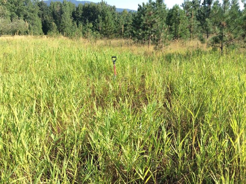
The scrub-shrub wetland association exists over major areas of the site. It is interspersed with emergent wetland
(though primarily dominated by canarygrass, Phalaris arundinacea [FACW]). It is dominated by alder (Alnus
incana [FACW]), with some spiraea (Spiraea douglasii [FACW]), willow (Salix scouleriana [FAC]), hawthorn
(Crataegus douglasii [FAC]), dogwood (Cornus alba [FACW]), and occasional cottonwood (Populus balsamifera
[FAC]). This association is primarily hydrophytic. Data Plot 11 is representative of this wetland.

Emergent wetland is dominated by meadow foxtail with considerable cover of rush (Juncus articulatus [OBL]),
small-wing sedge (Carex microptera [FACU]), and canarygrass. Some areas contains considerable tansy (an upland
species). This association is hydrophytic. Data Plots 1, 4, 7, and 8 are representative of this wetland.

Upland forest consists of grandfir (Abies grandis [FACU]), Douglas fir (Pseudotsuga menziesii [FACU]), pines
(Pinus ponderosa, Pinus monticola [FACU]) over serviceberry (Amelanchier alnifolia [FACU]), snowberry
(Symphoricarpos albus [FACU]), Rocky Mtn maple (Acer glabrum [FACU]), trailing blackberry (Rubus ursinus
[FACU]), and Oregon grape (Berberis repens [UPL]). It is located on the higher hillsides in the northwest portion of
the site. The association is non-hydrophytic. Data Plot 9 is representative of this area.

Wetland forest consists of cedar (Thuja plicata [FAC]), cottonwood (Populus balsamifera [FAC]) and alder (Alnus
incana [FACW]). Associated with the unnamed creek traversing the property from the northwest through the center
and discharging south at the southeast corner of the property, it also contains considerable floodplain benches with
ladyfern (Athyrium filix-femina [FAC]) and skunk cabbage (Lysichiton americanum [OBL]). It shows a well-
developed native mix of riparian species growing on mucky, saturated soils. The association is hydrophytic. Data
Plot 6 is representative of this wetland.

These associations are generally heterogeneous and their separation artificial.

Soils
General
The area was mapped by the National Resources Conservation Service (NRCS) as containing Map Unit 31 —
Mission silt loam 0-2% slopes; Map Unit 34 — Odenson silt loam 0-2% slopes, and Map Unit 35 — Pend Oreille
silt loam 5-45% slopes (Figure 2).

Mission silt loam is somewhat poorly drained, located on undulating to rolling topography, and derived from silty
glacial lake-laid sediments derived from mixed sources. Permeability of this soil series is very slow and there is
often a hardpan within the upper 20 inches. It is a classified as an ochreptic fragixeralf (this means the soil has a
surface layer that is low in organic matter, often mottled at depth, slowly or moderately slowly permeable to water;
the soil formed in a Mediterranean climate of wet winters and dry summers, and has a subsurface layer that is high
in crystalline clays). In spite of the occasional hardpan, this series is not considered hydric. It does, however,
potentially contains hydric soil inclusions.

Odenson silt loam is poorly drained, located in low areas on terraces, and derived from silty glacial lake-laid
sediments derived from mixed sources. Permeability of this soil series is slow and there is seasonal high water table
at a depths of 6 to 24 inches from February to June. It is classified as an andaqueptic haplaquoll (which means it
formed recently in andesitic-based areas in a groundwater-based hydrologic condition [aquic moisture regime], and
is a mollisol [a soil with a surface horizon darkened by organic matter] that is seasonally saturated [anaerobic] due to
groundwater). Largely because of its seasonally saturated conditions, it is considered hydric.

Tom Duebendorfer (208) 290-5992     Wetland Delineation: 10404 West Pine Street, Sandpoint, ID                  3
Tom Duebendorfer (208) 290-5992
Wetland Delineation: 10404 West Pine Street, Sandpoint, ID

                                                             NWI
                                                             PFO1C = palustrine, forested deciduous, seasonally flooded                                                       Figure 2
                                                                                                                                  USDI National Wetland Inventory and NRCS Soils Map
4

                                                             PEM1C = palustrine, emergent, persistent, seasonally flooded
                                                             NRCS                                                                                                          Elan Hazan
                                                             Map Unit 31: Mission silt loam 0-2% slopes - has hydric inclusions                  10404 West Pine Street, Sandpoint, ID
                                                             Map Unit 34: Odenson silt loam 0-2% slopes - has hydric inclusions
                                                             Map Unit 35: Pend Oreille silt loam 5-45% slopes - not hydric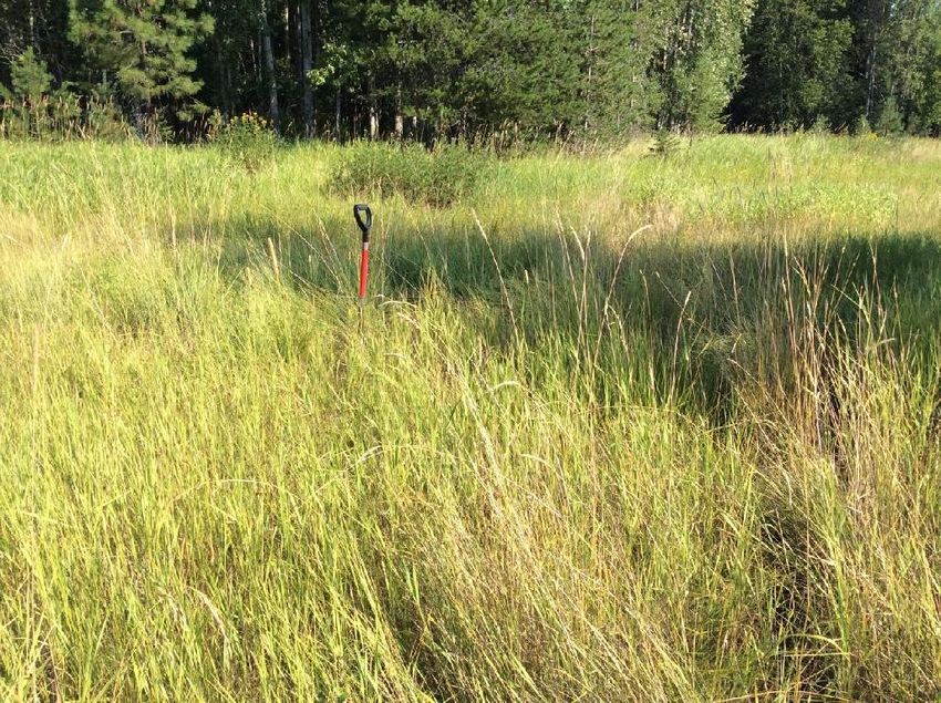
Pend Oreille silt loam is well drained, located in rolling to steep soils on foothills, and formed in glacial till.
Permeability of this soil series is moderate. It is classified as an andic xerochrept (which means it formed recently in
andesitic-based areas in a dry hydrologic condition). This series does not meet the National Technical Committee for
Hydric Soils (NTCHS) definition for hydric soil.

Specific
Eleven formal and numerous other undocumented soil data pits were excavated and inspected for hydric conditions.
Profiles excavated during the field survey typically displayed surface horizons of 10YR 3/2 over 10YR 2/2, 10YR
4/4 or 10YR 2/1 matrices. Upland soils were often 10YR 2/2 to 4/4, while the wetland soils were commonly 10YR
2/1. Redoximorphic features were common in the lower horizons of the pasture areas (Appendix C).

Hydrology
General
The National Wetlands Inventory (NWI) showed the majority of the project area as palustrine wetlands including
PFO1C (forested, broad-leaved deciduous, seasonally flooded), and PEM1C (emergent, persistent, seasonally
flooded) (Figure 2).

Specific
Hydrology to the site appears to derive from high spring runoff (from upslope areas to the north and west), the
unnamed creek, and precipitation in the lower pasture areas. Much of the wetland is essentially a seasonal system,
and dries completely in later summer months. However, the 3-5' wide creek had flowing water and saturated narrow
floodplain areas. In the northwest forested area, associated with the creek, saturated and mucky soils conditions
were present and hydrology was assumed to be perennial.

Wetland Determination
Based on the formal data plots and the site survey, it was determined that a considerable area of the property is
wetland (Figure 3). In the southern portion of the property, Wetland “A” consists of open ground dominated by
meadow foxtail, canarygrass, occasional water ragwort (Senecio hydrophiloides [FACW]), and aster, interspersed
with areas of tansy (not a wetland species). This area showed evidence of ponding in small rivulets or channels
running throughout the meadow. The wetland contains perhaps 10-15% small upland mounds in between the areas
where evidence of ponding is apparent. These areas were too common, random, and numerous to identify separately
out as upland. In the lower channel areas, Arctic rush (OBL) was present, attesting to positive wetland hydrology. It
is assumed, therefore, much of the area ponds for short to long duration during the early spring months. The soils
were not strongly hydric, however, according to the National Technical Criteria for Hydric Soils, soils that are
ponded for long duration (7 consecutive days during the growing season) are considered hydric, regardless of
characteristics observable in the soil profiles. Thus, surface expression (evidence of ponding) was the main criterion
(along with hydrophytic vegetation) in determining the upland boundaries of this wetland. Wetland A encompasses
4.01 acres within the property and “terminates” into a roadside ditch running along the north side of West Pine
Street. It is assumed any hydrology leaving the site from Wetland A eventually discharges into Chuck’s Slough to
the east. This wetland would be classified as palustrine, emergent, persistent, seasonally flooded (PEM1C).

The “Main” wetland occupies considerable extent on the property, encompassing 10 acres within the property
boundaries. It arises from two sources: one in the northwest portion of the property associated with hydrology from
the unnamed creek, and one from the northeast from off-site areas. It contains a well-developed forested component
with cedar, cottonwood, and alder over ladyfern and skunk cabbage (along the unnamed creek), as well as a more

Tom Duebendorfer (208) 290-5992     Wetland Delineation: 10404 West Pine Street, Sandpoint, ID                  5
Dark and light green shaded areas are
   National Wetland Inventory Wetlands
              DP = Data Plots
   White lines denote wetland boundaries

         Main Wetland
          10.0 acres

     Wetland "E"
     0.08 acres

                            Wetland "A"
                            4.01 acres

                                             Total Wetland Area 14.09 acres

                                                                                                               Figure 3
                                                                                              Wetland Delineation Map
            0         125         250                   500 Feet                                            Elan Hazan
                                                                                  10404 West Pine Street, Sandpoint, ID

Tom Duebendorfer (208) 290-5992     Wetland Delineation: 10404 West Pine Street, Sandpoint, ID                6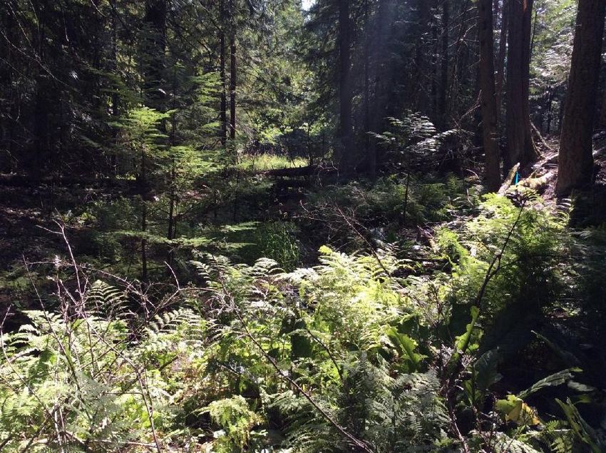
open area of 100% canarygrass interspersed with alder, willow, and hawthorn. In the northwest portion, the
unnamed creek floodplain ranges from narrow to fairly wide with mucky saturated soils and the flowing creek. As it
trends east and south it intersects with the alder, hawthorn, willow over canarygrass area which is quite extensive
(northcentral portion of the wetland). As the wetland trends south, it narrows within a steeper creek floodplain. It
discharges under West Pine Street in a culvert. Its discharge also likely ends in Chuck’s Slough. The “Main”
wetland would be characterized as palustrine, forested, deciduous, (and evergreen) ,seasonally flooded PFO1C,
PFO2C in its upper reaches and palustrine, scrub-shrub, deciduous, seasonally flooded (PSS1C) in the alder /
canarygrass area.

Wetland “E” is a small swale-like wetland dominated by canarygrass, mannagrass (Glyceria elata [OBL], and
impatiens (Impatiens noli-tangere [OBL]). It is hydrologically fed from areas offsite to the east and probably is
charged with surface water for short periods during the growing season. Topographically below the eastern
boundary, the vegetation changes to upland species, attesting to its short-duration hydrology and a topographic
break. It encompasses about 0.08 acres and would be classified as palustrine, emergent, persistent, seasonally
flooded (PEM1C).

Total on-site wetland area is 14.09 acres. These wetlands would be considered by the Corps of Engineers as
jurisdictional and thus regulated under the Clean Water Act. It is possible that Wetland E may be considered isolated
and hence not regulated by federal law - but only the Corps can make that determination. Figure 3 shows the
delineation boundaries and data plot locations. Figure 4 shows general vegetation habitat types and the photograph
locations.

Tom Duebendorfer (208) 290-5992     Wetland Delineation: 10404 West Pine Street, Sandpoint, ID                7
Ph 6

                                                                                                                emergent wetland
          upland forest
                                                                                                                  canarygrass,
    grandfir, Douglas fir, pine,
                                                wetland forest                                                 meadow foxtail, rush
     snowberry serviceberry,
                                           grandfir, cedar, ladyfern,       wetland scrub-shrub
         Oregon grape
                                               skunk cabbage             alder, hawrhorn, dogwood,
                                                                                 canarygrass

                    Ph 5                                                                                               upland
                                                                                                                     pine forest
                                                            upland forest
   upland forest                                      grandfir, Douglas fir, pine,
                                                       snowberry serviceberry,
                                                           Oregon grape

                                                                                                             disturbed upland
                                                                                                                 “pasture”

  emergent wetland
    canarygrass
                                                                                Ph 3
                                                                        Ph 4

                                                                                                 disturbed upland
                                                              emergent wetland                       “pasture”
                                                                canarygrass,
                                                             meadow foxtail, rush

                                                                                          Ph 2       Ph 1

                                                                                                                Figure 4
                                                                               Vegetation and Photograph Locations Map
         0            125          250                    500 Feet                                           Elan Hazan
                                                                                   10404 West Pine Street, Sandpoint, ID

Tom Duebendorfer (208) 290-5992          Wetland Delineation: 10404 West Pine Street, Sandpoint, ID                                8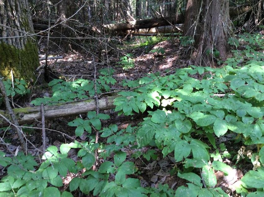
Montana Wetland Functional Assessment

Although no development plans have been proposed, the client has asked me to complete a Montana Wetland
Functional Assessment Method (MWAM) to determine the wetland functions to ascertain potential Wetland Credits
to be purchased from the Valencia Wetlands Trust (VWT) Wetland Mitigation Bank. Should wetland fills be
proposed, the mitigation sequencing by the Corps requires the following: avoidance, minimization, followed by
compensation. According to the 2008 Final Mitigation Rule (Federal Register/Vol. 73, No. 70 / Thursday, April 10,
2008 / Rules and Regulations), under § 332.1 (c) the Final Mitigation Rule maintains the requirements set forth in
Section 404(b)(1) Guidelines at 40 CFR part 230 which state that “the permit applicant [is required] to take all
appropriate and practicable steps to avoid and minimize adverse impacts to waters of the United States.
Practicable means available and capable of being done after taking into consideration cost, existing technology,
and logistics in light of overall project purposes. Compensatory mitigation for unavoidable impacts may be
required to ensure that an activity requiring a section 404 permit complies with the Section 404(b)(1)
Guidelines” (emphasis mine). According to § 230.93 (a)(2), restoration of impacted wetland is the first priority in
the compensation sequence followed by purchasing credits (employing the use of approved Wetland Mitigation
Banks within the service area) § 230.93 (b)(2).

I completed the five forms (the Valencia Mitigation Bank uses the 1999 MWAM to assess wetland credits to be used
as compensation for unavoidable wetland fills) and the results are presented in Appendix D.

Wetland “A” scored 3.8 Functional Units (out of 10 possible); the “Main” Wetland scored 6.4 Functional Units (out
of 11 possible). Wetland E was too small to be assessed accurately.

How this is implemented, after the proposed development demonstrates avoidance and minimization, should
wetland fills become necessary, these Functional Unit values would be multiplied by the acreage of wetland fill to
determine number of credits required to be purchased (e.g., for one acre wetland fill in Wetland “A”, 1 x 3.8 = 3.8
Bank Credits to be purchased; and for the “Main” Wetland, one acre wetland fill x 6.4 Functional Units = 6.4 Bank
Credits to be purchased).

                                                                                                  Regulatory Requirements

Types of Permits - Corps of Engineers

Under the Clean Water Act, the Corps has the authority to regulate the discharge or fill or dredged material into
“Waters of the US”. There are three Permits the Corps uses to regulate fill into wetlands.

(1) Nationwide General (NWP): This permit is authorized for specific activities nationwide with minimal impact
and minimal evaluation time. The NWPs typically have a ½ acre limit for fill in wetlands and 300 linear foot limit
for fill in stream channels. A Pre-Construction Notification application (PCN) must be submitted to the appropriate
field office (Walla Walla District). Typically, less than 1/10-acre of wetland fill does not require mitigation (though a
PCN is required), and up to ½ acre of wetland fill, requires mitigation.

(2) Regional General: Authorized for unique activities in a specific state. These are general permits (GP) for
activities that typically only occur in certain area, have minimal impact with minimal evaluation times. A PCN can
also be used to apply for a general permit when appropriate. This permit is probably not appropriate for your site.

Tom Duebendorfer (208) 290-5992      Wetland Delineation: 10404 West Pine Street, Sandpoint, ID                   9
(3) Individual: This a standard permit that authorizes activities that exceed the limits of the nationwide permits
(greater than ½ acre wetland fill), or if the activity does not meet the conditions of an available NWP. Individual
permits are generally reserved for projects with potential for substantial environmental impacts. This permit
requires a full public interest review, including public notices and coordination with involved agencies, interested
parties, and the general public. The individual permit application is different from the nationwide permit
application.

When any permit application is received, it is evaluated based upon three criteria: avoidance, minimization, and
mitigation. Once the applicant meets these criteria, a permit can be issued.

Most individual permits are issued through a process, which begins with a permit application to a Corps office.
Once a permit application is submitted, the Corps must notify the applicant of any deficiencies in the application
within 15 days. After the applicant has supplied all required information the Corps will determine if the application
is complete. Within 15 days of that determination, the Corps is required to issue a public notice of the application
for posting at governmental offices, facilities near the proposed project site, and other appropriate sites. In the
public notice, the Corps requires that any comments be provided within a specified period of time, usually 30 days
(though in my experience, this generally extends past 45 days).

The following is a summary of the typical processing procedure for a standard Individual Permit:
  1      Pre-application consultation (optional)
  2      Applicant submits ENG Form 4345 to district regulatory office.
  3      Application received and assigned identification number.
  4      Public notice issued (within 15 days of receiving all information).
  5      15 to 30 day comment period depending upon nature of activity.
  6      Proposal is reviewed by the Corps and the public, special interest groups, local agencies, state agencies, and
         federal agencies
  7      Corps considers all comments, and other federal agencies are consulted, if appropriate
  9      District engineer may ask applicant to provide additional information.
  10     Public hearing held, if needed.
  11     District engineer makes decision.
  12     Permit issued or permit denied and applicant advised of reason.

After evaluating all comments and information received, a final decision on the application is made. The final
decision is made on a case-by-case evaluation and is generally based on the outcome of the public notice process
and a determination of project benefits versus detriments (wetland losses). A permit will most likely be granted
unless the proposal is found to be contrary to the public interest. Processing time takes approximately 120 days after
the complete application packet has been submitted, unless a public hearing is required or an environmental impact
statement must be prepared.

 The Section 404(b)(1) Guidelines are the substantive criteria developed by Environmental Protection Agency and
used by the Corps to evaluate proposed discharges into waters of the United States. The Corps is required to analyze
alternatives to the proposed project and may not issue a permit under Section 404 if the proposal does not meet the
404(b)(1) Guidelines. The Corps may only issue a permit for the least environmentally damaging practicable
alternative. Practicability includes cost, existing technology, and logistics.

Under the 404(b)(1) Guidelines, the level of review of a proposed project is commensurate to the level of impact to
waters of the U.S. The Corps may not issue a permit if the proposed project is not in compliance with other laws
(such as Section 401 of the Clean Water Act; National Environmental Policy Act; Fish and Wildlife Coordination
Act ; Endangered Species Act (threatened or endangered species information); National Historic Preservation Act; if
the activity would result in significant degradation of aquatic environment (net after mitigation); or if there is not
appropriate and practicable mitigation. Public interest reviews, Section 404(b)(1) analyses and National

Tom Duebendorfer (208) 290-5992     Wetland Delineation: 10404 West Pine Street, Sandpoint, ID                         10
Environmental Policy Act analyses require a resource impact assessment, which may include Wetland Evaluation
Technique (WET), Habitat Evaluation Procedures (HEP), Hydrogeomorphic Approach (HGM) for wetlands or the
EPA’s rapid bioassessment method for streams.

Required submittals with the Individual Permit Application:
        Application Form
        Project Description and Drawings
        Project Purpose and Need
        Jurisdictional Determination
        Threatened & Endangered Species Assessment
        Cultural Resources Evaluation
        Environmental Assessment / Alternatives Analysis
        Project Mitigation Plan
        State Water Quality Certification - Through Idaho DEQ

Public Interest Evaluation
The Corps will evaluate impacts associated with the proposed project, including cumulative impacts, on the public
interest. The public interest factors include:
          Conservation Navigation
          Floodplain / Values / Aesthetics
          Water Supply & Quality Needs & Welfare of People
          General Environment / Wetlands
          Fish & Wildlife Values / Mineral Needs / Property Ownership
          Energy Needs Cultural Values Safety
          Flood Hazards Recreation
          Shore Erosion & Accretion / Food & Fiber Production / Land Use
          Economics

The public interest evaluation will involve the balancing of the public interest factors many of which may be in
conflict. The Corps will consider:
          Benefits vs. Detriments
          Extent and Permanence of Benefits and Detriments Public vs. Private Need

Corps Application Evaluation and Decision
        The Corps will issue Individual Permit if:
                 (1) the proposed project is not contrary to the public interest, and
                 (2) satisfies Section 404(b)(1) Guidelines requirements.

City of Sandpoint
There are numerous requirements associated with Planned Unit Developments (www.sterlingcodifiers.com/
Sandpoint, ID). I would suggest you or your engineers peruse this website for details. It does not appear that the
City of Sandpoint requires any building setbacks to wetlands. Depending on your proposed development plan, these
elements and requirements should be assessed for pertinence regarding any proposed lot layouts, increased densities,
etc. The elements and requirements are too detailed and varied to itemize in this report.

Tom Duebendorfer (208) 290-5992     Wetland Delineation: 10404 West Pine Street, Sandpoint, ID                11
Soils: Hydric soil is defined as soil that is saturated, flooded, or ponded long enough during the growing season to develop anaerobic conditions in the upper part. In accordance with the methodology, soil samples were taken at all data plots as well as other points on the site. The test of this definition is met when the following indicators of hydric conditions are present, direct observation of flooding, ponding, or surface saturation, thick organic layers, and low soil matrix chromas (chroma of 1 without redoximorphic features or chroma of 2 or less and value of 4 or more with redoximorphic features). Low chroma soils are indicative of reducing conditions (typically during the growing season when soil oxygen is being utilized by soil microorganisms as well as plants). Redoximorphic features occur in areas of fluctuating water table levels (alternating reducing and oxidizing environments). Soils were moistened during the dry season to accurately determine colors on the Munsell Color Charts. During the dry season, apparent surface indicators of wetland hydrology was used to assess flooding or ponding. Duration of flooding, ponding, or saturation is also important. Hydric soils must be flooded or ponded for long (7 to 30 days) or very long (more than 30 days) duration during the growing season. Hydric soils must be saturated in the upper part for a significant period (usually more than one week) during the growing season. Hydrology: Wetland hydrology is defined as all hydrological characteristics of area that are periodically inundated or have soils saturated to the surface at some time during the growing season. The criteria are: (1) inundation (flooding or ponding) occurring for 7 consecutive days or longer during the growing season in most years (50% chance or more); or (2) saturation at or near the surface occurring for 14 consecutive days or longer during the growing season in most years (50% chance or more). Soils may be considered to be saturated to the surface when the water table is within: (a) 0.5 ft of the surface for coarse sand, sand or fine sandy soils; or (b) 1.0 ft of the surface for all other soils. Areas with evident characteristics of wetland hydrology are those areas where the presence of water has an overriding influence on characteristics of vegetation and soils because anaerobic and reducing conditions exist. The test of this definition is met when data plots show direct observation of wetland hydrology, or a sufficient number of apparent indicators, including indirect evidence of flooding, ponding, or saturation, water marks, drainage patterns, oxidized root rhizospheres, water-stained leaves, or sediment deposits. Duration of hydrologic conditions creating anaerobic and reducing conditions must also be satisfied. Wetland Determination Jurisdictional wetlands were delineated where vegetation, soils, and hydrology all reflect anaerobic conditions as defined and described above. Topography, when diagnostic of hydrologic confines, was considered in refining the wetland boundary. Wetland boundaries were identified and flagged (labeled with blue ribbon flagging, or staked in open areas), and mapped using ESRI ArcMap on a NAIP Bonner County 2013 aerial photographs as well as Bing aerials. The wetland boundaries were located using a sub-meter handheld GPS unit. The point shape files of the wetland points are available upon request. Tom Duebendorfer (208) 290-5992 Wetland Delineation: 10404 West Pine Street, Sandpoint, ID 15
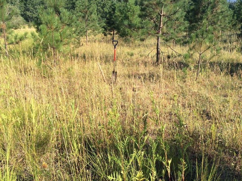
Photo 1: View north into area of Data Plot 1. Upland weedy Photo 2: View north into area of Data Plot 2. Wetland species,
species canarygrass, rush. Numerous channels showing evidence of ponding
throughout this area
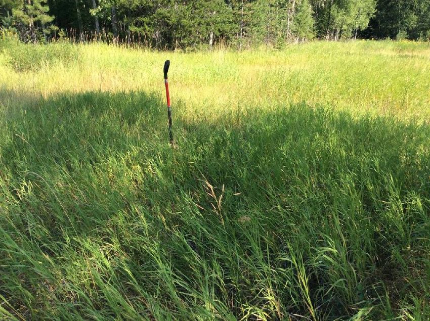
Photo 3: View north into area of Data Plot 3. Upland species, Photo 4: View north into area of Data Plot 4. Wetland
mostly smooth brome. species, canarygrass, rush. Numerous channels showing
evidence of ponding throughout this area
Photographs (August 3, 2018)Photo 5: View east into wetland riparian area of forested wetland. Unnamed
creek runs through, wide floodplain with cedar edges, ladyfern and skunk
cabbage. Mucky saturated soils.
Photo 6: View west into a “dry” swale. Upland herbaceous species, though
area appears to provide some surface runoff to large wetland.
Photographs (August 3, 2018)You can also read