Ready for Galileo? Jens Riecken, 01.07.2014, Kaliningrad - CLGE-Conference of the European Surveyor and Geoinformation. F.G.W. Struve - European ...
←
→
Page content transcription
If your browser does not render page correctly, please read the page content below

CLGE-Conference of the
Ready for                 European Surveyor and
Galileo?                  Geoinformation.
                          F.G.W. Struve – European
Jens Riecken,             surveyor of the year 2014
01.07.2014, Kaliningrad
Outline - Ready for Galileo?

The MS Perspective
Example Germany: Satellite Positioning Service SAPOS®

The European Perspective:
Perspective for the integration of Galileo
SAPOS® - German GNSS system

• More than 270 reference
  stations
• Nationwide provision and
  integration of SAPOS®- data
• Exchange of SAPOS®- data
  between the states
• Technical support for the
  cross-border networking
SAPOS® - Services - Accuracies

            Real time                              Post Processing

    EPS                    HEPS                                GPPS
   0,3-0,8 m               1-2 cm                               < 1 cm

  Provision by       Provision by mobile                      Provision by
 mobile Internet      Internet and GSM                        Webserver

Data format RTCM      Data format RTCM                     Data format RINEX

                   EPS:    Real Time Positioning Service
                   HEPS:   High Precision Real Time Positioning Service
                   GPPS:   Geodetic Precision Positioning Service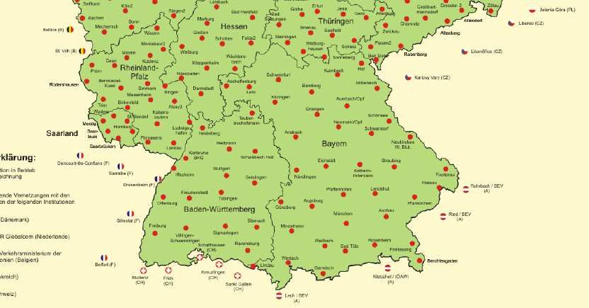
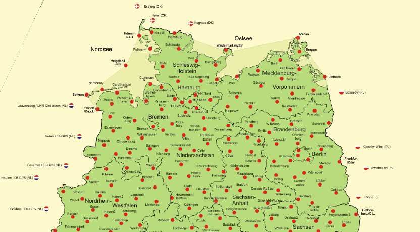
SAPOS® in North-Rhine Westphalia

        Part of the German SAPOS®-network
        50 stations in processing
               27 stations in NRW
               i.g. on public buildings
               Distance apart 45 km

        Co-operation with neighboring countries
               Data exchange

        Processing since 2003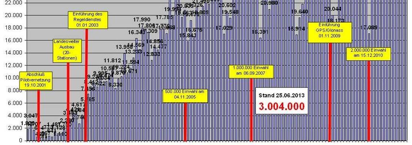
SAPOS® in North-Rhine Westphalia

  Access to High
Precision Real Time
Positioning Service
 (HEPS) per month

                        G1                G2
                       (GPS)         (GPS/GLONASS)
Integration GPS/GLONASS in NRW
     Parallel to the G1-service, redundant implementation of G2
     G1     G2, starting from 01.11. 2009

27 reference stations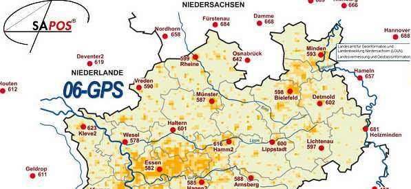
antenna calibration

                             relative antenna calibration

                                      absolute antenna calibration
                                      (AMK Bonn)
absolute antenna
calibration (roboter)
Geo++
(IGS-Standard)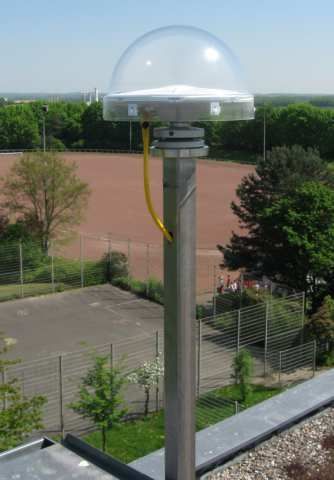
SAPOS Reference Stations
                                Antennas ready for Galileo

about 270 reference stations
Antennas: currently about 50%
ready for Galileo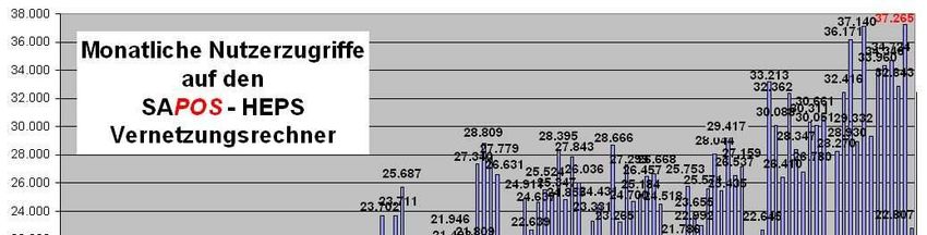
SAPOS®-NRW (2013)
                                    telecommunication – a big issue

                         Central access point

     User                      SAPOS®
                         Germany (Hannover)
                                                             User

                                                                      Central access
                                                                      point SAPOS®
                                                                       NRW Bonn

  NRW
Station 27
                                                   Ntrip            Webserver
                                       Backbone
  ...
                                                           Backup
      NRW
    Station 3

                                                           public
        NRW
      Station 2                                            Internet

               NRW
             Station 1
Telecommunication – a big issue
Need for Standardization
Interoperability (RTCM) vs.
individual company solution
mbps RTCM 3.2
12 I
10 I
limited data capacity
8I RTCM MSM
6I
4I
2I
-----------------------------------------------------------
Need for Implementation
4 8 12 16 20 24 28 32 36 40
satellitesGeodetic Reference
SAPOS® implementation&tests
The integration of
GLONASS
The geodetic referenceGalileo
The European Perspective:
SAPOS ® in the context of Galileo
technical issues / ready for Galileo
time scale (estimation)
the view of CLGE next 5 slides provided by:
European Commission
DG Enterprise and Industry
Unit Galileo and EGNOS
- Applications, Security, International Relations
25.06.2014Policy Developments 2013 has been instrumental in shaping and securing the long term programme structure New Regulations adopted for the European GNSS Programmes and for the European GNSS Agency Funding secured for EGNOS and Galileo for the new financial framework 2014-2020 Exploitation tasks conducted by the European GNSS Agency under delegation System design and development tasks conducted by the European Space Agency under delegation 10 July, 2014 14
2014 -2020: New framework

A stable 7 years perspective

A new governance scheme driven by exploitation

           2014-2020

1, 930 B€ for Galileo Deployment

3 B€ for Galileo Exploitation

1,580 B€ EGNOS Exploitation
Galileo implementation plan
Full Operational Capability
Full services, 30 satellites
Galileo is implemented
2020
in a step-wise approach
Early Services
for OS, SAR, PRS,
and demonstrator for CS
2015
In-Orbit Validation
4 fully operational satellites and
ground segment
2013
GIOVE A/B
2 test satellites
2005/2008
Galileo System Testbed v1
Validation of critical algorithms
2003Galileo services
Early services for OS, SAR and PRS will be provided from 2015
Freely accessible service for
Open Service (OS)
positioning, navigation and timing
Public Regulated Service Encrypted service designed for greater
(PRS) robustness and higher availability
Search and Rescue Assists locating people in distress and
Service (SAR) confirms that help is on the way
Delivers authentication and high accuracy
Commercial Service (CS)
services for commercial applications
The former "Safety-of-Life" service is being re-profiled:
Integrity Monitoring Provides vital integrity information
Service for life-critical applications
“the intention is to have a sufficient number of satellites available to ensure early services”Galileo services provision timeline
Early services will be provided from 2015 with a gradual transition towards
full services as more satellites become available
2012 2013 2014 2015 2016
Stable good quality signals
Early
service
Combined with Enhanced
GPS service
Open Service
Early Enhanced
Demonstrator service service
Public Regulated Service
Early Full
service service
Search and Rescue
Service
Demonstrator Early
service
Commercial Service
“the intention is to have a sufficient number of satellites available to ensure early services”The adoption of the Galileo SAPOS®
G3 (GPS/GLONASS/Galileo)
implementation plan to SAPOS® 2018
Galileo implementation&tests Full Operational Capability
2016/17 Full services, 30 satellites
SAPOS® on duty 2020
DGNNS – G2 (GPS/GLONASS)
Galileo taskforce Early Services
for OS, SAR, PRS,
2010 and demonstrator for CS
AdV-decission “future SAPOS®“
Integration of GLONASS and Galileo 2015
2006 In-Orbit Validation
4 fully operational satellites and
SAPOS® on duty ground segment
DGNNS - G1 (GPS)
2003 2013
GIOVE A/B
2 test satellites
2005/2008
Galileo System Testbed v1
Validation of critical algorithms
2003Ready for Galileo? The position of CLGE: 1) Umeå Statement 2011 (CLGE seminar): „The Geodetic Infrastructure in Europe – today and tomorrow” 2) CLGE’s contribution to the public consultation about the applications of EU satellite navigation programmes (Galileo and EGNOS) Spatial data … has become of increasing importance for the development of society. The economic potential and the benefits for society are immense and will further increase with INSPIRE, Egnos and Galileo. The surveying community ... must be able to meet the requirements of European society, industry and users in order to create and maintain a homogeneous, sustainable geodetic infrastructure and guarantee its availability.
Ready for Galileo?

The position of CLGE:
1) Umeå Statement 2011 (CLGE seminar):
„The Geodetic Infrastructure in Europe – today and tomorrow”
2) CLGE’s contribution to the public consultation about the
applications of EU satellite navigation programmes
(Galileo and EGNOS)

Thanks to GNNS-services the surveying and mapping processes
are around 30% faster by using 30% less staff. Therefore it is
essential to have the GNSS-services available. Galileo will
guarantee this! Moreover in combination with the existing
services (GPS and GLONASS) it will lead to better accuracy and
even faster solutions, so it will produce additional benefit.
Ready for Galileo?

The position of CLGE, 2014:
CLGE strongly supports Galileo as an additional GNSS system and
the European contribution to world wide satellite navigation and
positioning.
CLGE strongly requests the European surveying community to
implement and use Galileo.
CLGE expects a sustainable implementation of Galileo without
further delays.
CLGE sees the need for further standardization to guarantee
interoperable solutions.
CLGE expects technical innovation in the context of precise point
positioning (PPP) and sees the need for an increasing
multinational cooperation.
Galileo and beyond (vision 2030): A high
                          precision European harmonized geodetic
                          reference Infrastructure (as part of INSPIRE)
                              Central access point

      User                          Europe                        User MS x

                                                                            Central access
                                                                            point Member
                                                                                State

  MS x
Station ...
                                                         Ntrip            Webserver
                                          Telecommuni-
   ...                                        cation
                                                                 Backup
       MS
    Station 3

                                                                 public
          MS
       Station 2                                                 Internet

                 MS
              Station 1
Ready for Galileo?
the situation in the MS
Discussion
Yes May Be No
Galileo and/or Beidou (G3/4)?
Time schedule available ?
Technique ready / resources (€) available ?
Interoperable standards (RTCM) vs.
individual company solution ?
Precise Point Positioning (PPP) on the agenda?
Common European approach?Thank you for your attention!
You can also read