PRESTON NEIGHBOURHOOD DEVELOPMENT PLAN - MADE PLAN 2020-2031 Prepared by Andrea Pellegram MRTPI, modified by Cotswold District Council following ...
←
→
Page content transcription
If your browser does not render page correctly, please read the page content below
PRESTON NEIGHBOURHOOD DEVELOPMENT PLAN
                                                                            2020-2031
                                                                        MADE PLAN

Prepared by Andrea Pellegram MRTPI, modified by Cotswold District Council
                                                                               May 2021
following Independent Examination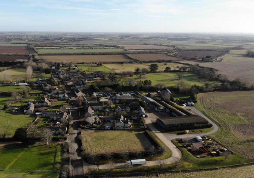
Preston NDP – Made Plan

Introduction by Chairman of the Steering Group
Neighbourhood Development Plans come out of the Government’s determination to
ensure that local communities are closely involved in the decisions which affect
them. The Preston Neighbourhood Development Plan has been developed to
establish a vision for the village and to help deliver the local community’s
aspirations and needs for the plan period 2018 – 2031. Our Neighbourhood
Development Plan is a statutory document that is part of the District planning
framework and will be used by Cotswold District Council to determine planning
applications.

Our Plan has been produced by local residents, under the aegis of the Parish
Council, using the views of the residents of Preston, with the invaluable assistance
of an experienced Planning Consultant. The Steering Group has consulted with and
listened to the community and local organisations on a wide range of issues that
will influence the well-being, sustainability and long-term preservation of Preston’s
rural community. Building on the Design Statement published in 2017, every effort
has been made to ensure that the views and policies contained in this document
reflect those of the majority of Preston residents.

An electronic copy of this Plan and the Evidence Papers supporting it can be found
online at www.prestonpc.org.uk

As Chair of the Steering Group I would like personally to thank particularly the
members of the Group and pay tribute to their work since May 2017 and our Parish
Clerk and Planning Consultant for their continued support. Many thanks are also
due to all those in the Parish who helped to write this Plan by filling in
questionnaires, attending meetings and offering views, without which it would not
have been possible to produce this Neighbourhood Plan.

Tony Warren

                                                                            1|Page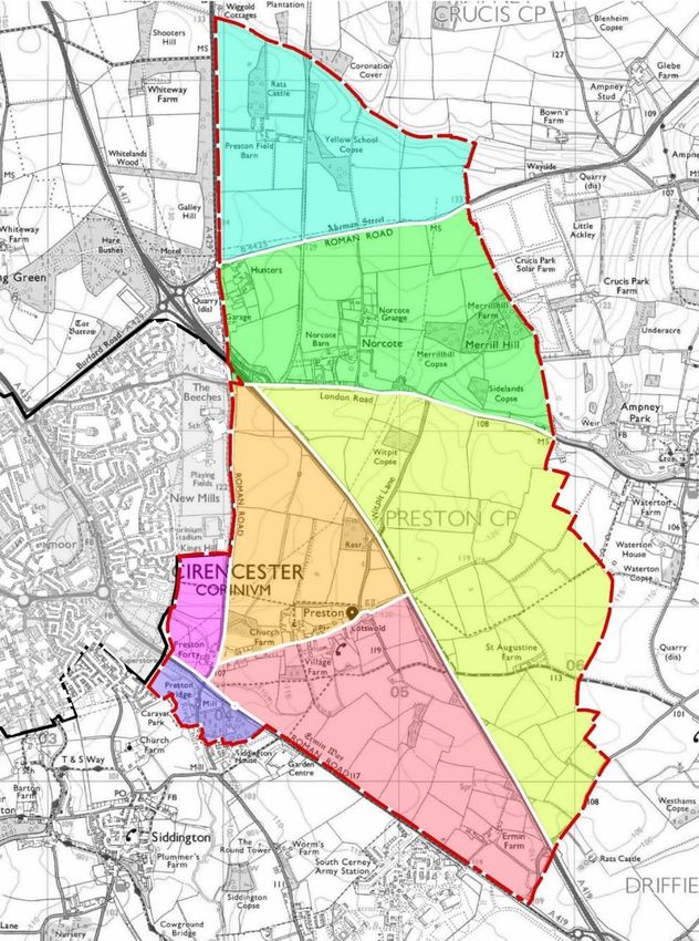
Preston NDP – Made Plan

Table of contents

Introduction by Chairman of the Steering Group                                    1

Table of contents                                                                 2

The role of the neighbourhood plan in the planning system                         3

NDP structure                                                                     4

Neighbourhood planning area                                                       5

Background to Preston Parish                                                      6

Demographic characteristics                                                       9

Engagement                                                                    13

Landscape                                                                     15

Design                                                                        22

Local Green Spaces                                                            27

Employment Land                                                               31

Footpaths and Cycleways                                                       36

Community Infrastructure                                                      39

Transport and Village Amenity                                                 42

                                                                      2|Page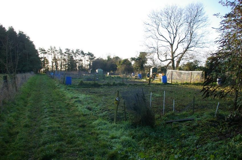
Preston NDP – Made Plan

              Made Plan                                              that have been made to this document, it
                                                                     should proceed to referendum.
              1. The Preston Neighbourhood
                                                                     4. Neighbourhood plans must meet
              Development Plan 2020-2031 was put to
                                                                     certain “basic conditions” and other legal
              the local electorate of Preston Parish on 6
                                                                     requirements before they can come into
              May 2021, where it met with approval,
                                                                     force. These are tested through an
              with 88.62% of the turnout voting in its
                                                                     independent examination before the
              favour.
                                                                     neighbourhood plan may proceed to
                                                                     referendum.1 Neighbourhood plans must
              The role of the                                        be in general conformity with the strategic
              neighbourhood plan in the                              policies contained in the development plan
                                                                     that covers their area2. Neighbourhood
              planning system                                        plans should not promote less
                                                                     development than set out in the strategic
              2. Neighbourhood Development Plans                     policies of the Cotswold Local Plan or
              (NDPs) were introduced by the Localism                 undermine those strategic policies.3 The
              Act 2011 and enacted in the                            preparation of planning policies should be
              Neighbourhood Plan Regulations 2012 as                 underpinned by relevant and up-to-date
              amended. NDPs are prepared by parish                   evidence.4
              councils for a designated area – in this
              case, Preston Parish Council prepared this
              NDP for Preston Parish. Once the NDP is
              “made”, i.e. has been adopted, it becomes
              part of the planning decision-making
              framework for Preston. Now the NDP has
              passed referendum, consideration of every
              planning application that is submitted in
              the parish must pay regard to the policies
              in this NDP.

              3. There are several stages in the
              preparation of an NDP. This NDP has
              already been subjected to extensive
              consultation in its production and in
              response to comments received to its
              public consultation under Reg. 14 of the
              Neighbourhood Planning Regulations.
              Subsequently it has been reviewed by an
              independent examiner, who has
              determined, that subject to modifications

1                                                      3
    National Planning Policy Framework, 37.                National Planning Policy Framework, 29.
2                                                      4
    National Planning Policy Framework, footnote 16.       National Planning Policy Framework, 31.

                                                                                                     3|Page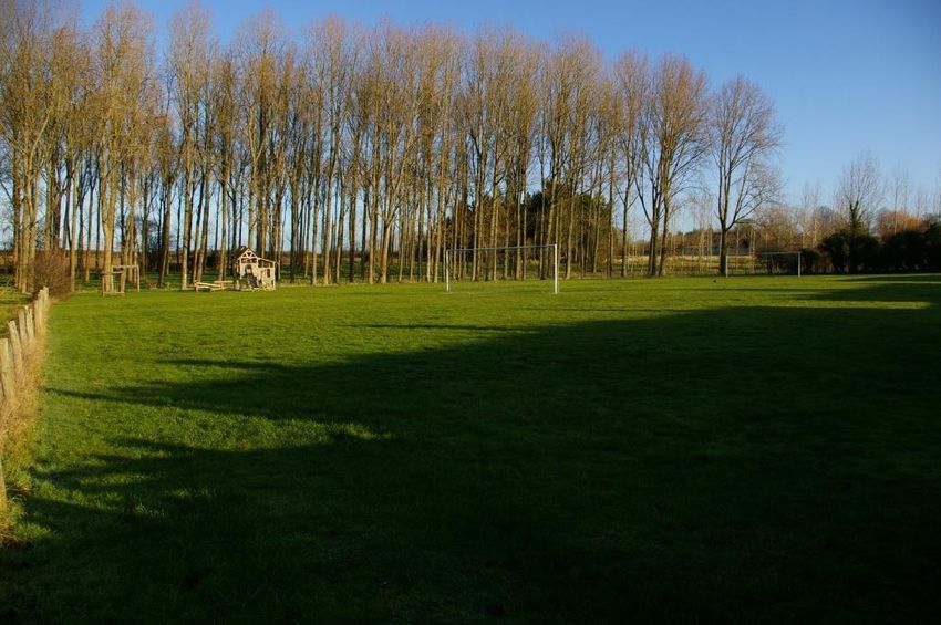
Preston NDP – Made Plan
5. The planning authority prepares the 8. The Submission Draft was
Local Plan. This sets out strategic policies accompanied by this background evidence.
that are applicable across the entire In addition, it was also supported by a
Cotswold District. The Preston NDP works Consultation Statement which sets out in
within those policies and adds local detail. detail how the community and other
Neighbourhood planning gives stakeholders were consulted about the
communities the power to develop a emerging NDP and describes how the
shared vision for their area. issues raised were addressed.
6. Once an NDP has been brought into 9. It was also accompanied by a
force, the policies it contains take statement that sets out how the NDP
precedence over existing non-strategic meets the Basic Conditions (requirements
policies in the local plan for Preston Parish. of para. 8 of the Schedule 4B of the Town
and Country Planning Act 1990.)
NDP structure 10. A Strategic Environmental Assessment
7. The NDP is the main document but has not been prepared because this was
each policy is based on evidence such as deemed to be unnecessary by the Local
the results of the community survey, Planning Authority in its SEA Screening
consideration of the Local Plan policies and Opinion (2018).
other information collected by the steering
group who have overseen the NDP’s
preparation. In the interest of brevity, the
NDP only summarises the evidence.
Applicants and others who are stakeholders in the planning process
are advised to consider the detailed analysis in the evidence papers.
Evidence in support of NDP policies
Evidence Papers prepared by the Steering Group
Community Infrastructure
Design in Preston
Employment Land
Sustainable Transport
Transport and Village Amenity
Landscape Character Assessment for Preston Neighbourhood Plan (July 2020, Portus &
Whitton Landscape Architects)
4|Page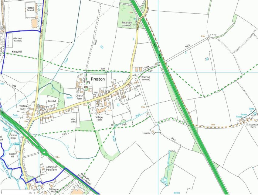
Preston NDP – Made Plan
Neighbourhood planning area
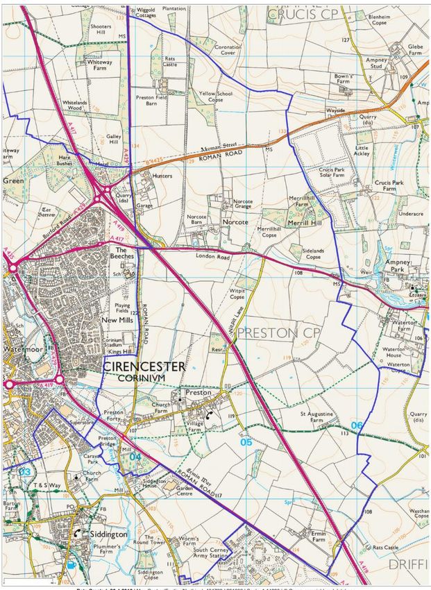
11. The area covered by this NDP is the parish of Preston shown in Figure 1. Cotswold
District Council approved Preston parish as the NDP area under the Neighbourhood Planning
Regulations 2012 and the Neighbourhood Planning (General) and Development Management
Procedure (Amendment) Regulations 2016 on 17 May 2017.
Figure 1: NDP area – the Parish of Preston
5|Page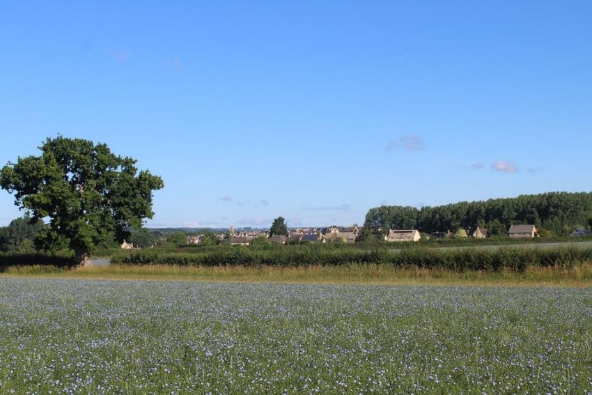
Preston NDP – Made Plan

Background to Preston Parish                       junction opposite the South Cerney Airfield
                                                   and west towards Cirencester.
12. The Village of Preston lies
                                                   16. Part of the new Kingshill Meadow
approximately 2 miles to the south east of
                                                   development on the outskirts of
Cirencester in Cotswold District. There is
                                                   Cirencester was formerly in the parish but,
good access to Cirencester by car and cycle.
                                                   as part of boundary reorganization, the
The A419 is easily accessible, and both
                                                   boundary was moved in 2015 to enable the
Swindon and Cheltenham can be reached
                                                   whole of that development to be part of
within 20 minutes. The 2018 community
                                                   Cirencester. Preston Parish Council
survey showed that Preston residents rely
                                                   supported the boundary change because
upon Cirencester and Cheltenham for
                                                   they felt that to accept a new and large
leisure, though a high proportion of
                                                   development would change the nature of
responders relied almost entirely on
                                                   the parish.
Preston and Cirencester to meet their
work, study and leisure needs.                     17. Archaeological finds from Preston
                                                   show evidence of occupation back to
13. The entire parish lies outside the
                                                   Neolithic times, through Roman, Saxon and
Cirencester Development Boundary5 and
                                                   medieval times to the present day.
therefore, only small scale residential
development will be permissible in the             18. The agricultural hamlet of Preston has
parish6. New-build open market housing is          stood in the Cotswold countryside for more
not permitted unless in accordance with            than a thousand years. Documented in the
other policies that expressly deal with            Domesday Book as being held by
residential development which is not the           Regenbald, (debatably) the chancellor of
case in Preston Parish7. The northern part         Edward the Confessor, it formed a part of
of the parish is designated as AONB and            the endowment to the Abbey of
there is a small employment area in the            Cirencester by Henry I in the mid part of
village.                                           the 12th century along with the majority of
                                                   Regenbald’s estates. So it remained over
14. The parish is composed mainly of
                                                   the course of the next four hundred years,
countryside with scattered dwellings and
                                                   until the Dissolution of the monasteries in
small businesses. The A417 travels through
                                                   the 1540s. The Church of Preston, like
the parish, effectively severing the north
                                                   other possessions of the Abbey, stayed in
and south of the parish, except for the
                                                   royal hands until it, along with other
bridge at Witpit Lane.
                                                   estates in the area, was purchased from
15. The Parish of Preston extends north            Queen Elizabeth by her physician, Dr.
along the Fosse Way (A429 Stow Road) to            Richard Master, in 1564.
Ragged Hedge Covert, East along London
                                                   19. That purchase began a relationship
Road (A417) to near the entrance of
                                                   between the Master (subsequently Chester
Ampney Park, south to the A419 road
                                                   Master) family and Preston that continues
                                                   to this day.

5                                                  6
 Cotswold District Council Local Plan 2011-2031,       Local Plan policy DS3.
                                                   7
Policy DS2.                                            Local Plan policy DS4.

                                                                                   6|Page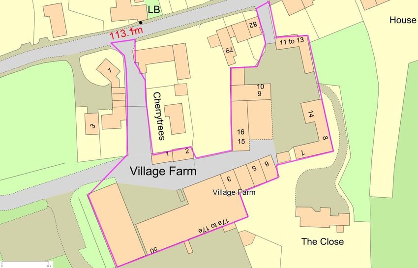
Preston NDP – Made Plan
20. The community remained stable and a welcoming space and is used by
between the time of the enclosure of the various clubs and organizations, as well
parish in 1772, and the Second World War, as social events organized in the village.
with the addition of an imposing new Village Playing Field: this located to
rectory in 1820. Two or three more the rear of what were Forty Farm
substantial farmhouses near the centre Cottages (now part of Kingsway) and is
were interspersed with smaller cottages, provided and maintained by Preston
forming a ribbon-like settlement along the Parish Council. It is a safe and enclosed
central part of the village road. area for children with play equipment
and football posts.
21. Between 1950 and 1980 the village Allotments: These are available for
expanded with new dwellings being built rent from the Chester Master estate
on intermittent sites along the roadside and are situated centrally to the south
from the crossroads at the western end to side of the village, behind The Barn.
the junction at the eastern end to the
Ampneys one way and Harnhill and
Driffield to the other. That development
was continued into the 1980s and 1990s
with the conversion of farm buildings into
both residential and small commercial
properties. However, the fundamentally
rural nature of the built area of Preston has
been maintained, despite a change in the
demography of the village from the
historical, purely agricultural, to the more
varied background of today.
22. In the centre of Preston village is a
conservation area. This is the oldest part
where the church, letter box, telephone
box and village hall can be found. There are
23 listed buildings in the parish. These
range from the 13th and 14th century
Anglican church with some monuments in
the churchyard, to individual houses and
farmhouses built in the 17th, 18th and 19th
centuries.
23. Preston relies upon a number of
community facilities:
All Saints Parish Church: this is part of
the Churnside Benefice along with
churches at Siddington, South Cerney
and Cerney Wick.
The Village Hall: this is the social hub
of the village. It was renovated by the
residents in 2008. It is a well-equipped
7|Page
Preston NDP – Made Plan

24. The parish area consists mainly of
undulating arable fields, typical of the
Cotswold landscape, that are surrounded
by hedges and dry stone walls. The area is
crossed by numerous drainage ditches and
is prone to limited localized field flooding.
To the north of Preston village, the fields
are dotted with several old dew ponds and
an underground reservoir is located to the
south of the A417, along Witpit Lane.
                                                 All Saints Church
25. There are no areas of designated SSSI
within the parish, but the area north of
Akeman Street is within the Cotswolds
AONB.

26. The parish is crisscrossed by the routes
of old Roman Roads (the Fosse Way, Ermin
Way and Akeman Street) and also includes
the route of a dismantled railway, now the
main access road to the Organic Farm shop
at Abbey Home Farm.

27. Most of the farmland is arable, though       Preston Village Hall
the Abbey Estate does have some livestock.
The parish is also dotted with a number of
copses, which help to break up the skyline.
The copses and drainage ditches also
provide excellent wildlife corridors.
Buzzards and green woodpeckers are
resident and red kites, heron, otters and
roe and fallow deer are often seen.

28. Despite its proximity to Cirencester,
the fact that most of the land is arable         Preston Playing Fields
farmland and subject to rotational cropping
helps to maintain the distinctly rural feel of
the parish.

                                                                          8|Page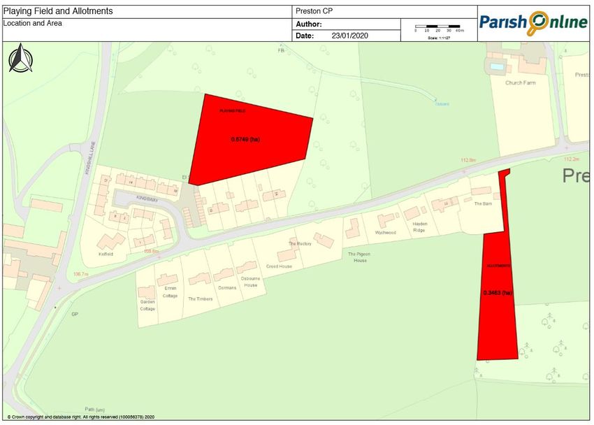
Preston NDP – Made Plan

    Demographic characteristics                       31. In total there were 118 households.
                                                      There were 327 usual residents (45% male,
    29. The key characteristics in the NDP are        55% female). The ethnicity is
    taken from the 2011 census8.                      overwhelmingly white (99.7%) and born in
                                                      the UK (99.6%).
    30. Most residents live within the village
    though there are some scattered individual        32. Preston is a community with a
    dwellings, mainly farms or former farms.          relatively older population: the mean age
    Hunters Care Home accounts for around a           is 54.8. This is skewed by Hunters but it
    quarter of residents. There were 327 usual        was not possible to determine the age
    residents in the parish on Census day 2011:       profile for the remainder of the residents.
    76.1% lived in households and 23.9% lived         In 2011, there were only 48 young people
    in communal establishments (Hunters).             under the age of 19, and over three times
    Excluding Hunters, around 250 people              as many people aged over 60. The 2011
    were resident in Preston in 2011 which is         age structure is illustrated in Figure 2 and
    the start of the Local Plan period. There         Figure 3 which shows that Preston has a
    are currently 250 people on the electoral         relatively older population than
    roll.                                             Gloucestershire or England though again,
                                                      this is skewed by Hunters Care Home.

Figure 2: Age Structure, 2011

                                PRESTON AGE STRUCTURE, 2011                          161
                                              62

                                                                56
                         48

                     AGE 1-19             AGE 20-44         AGE 44-59          AGE OVER 60

            Source: 2011 census

            Figure 3: Comparative age profile, 2014

8
 https://www.nomisweb.co.uk/reports/localarea?comp
are=1170214123

                                                                                           9|Page
Preston NDP – Made Plan
Source: Gloucestershire Parish Profiles Report, created 8 November 2016
10 | P a g ePreston NDP – Made Plan
33. Of the residents over the age of 16, homes are owned (66%) and the remainder
49% were married, 23% were widowed, are rented (14% of all properties are social
and 22% had never married. rented). One third of all homes have only
one occupant and the remainder are
34. The population is healthy, where two occupied by families. The Community
thirds of census respondents classified Survey, undertaken in 2018, showed that
themselves as very healthy or in good 55% of respondents lived in detached
health and not limited in their daily homes and another 30% in semi-detached
activities. These figures would probably be homes. On average, responders had been
higher if Hunters Care Home is excluded. at the same address for 21 years and few
responders wished to move or downsize.
35. Most people lived in detached
properties (44%) or semi-detached 36. On average, 36% of adults in each
properties (38%), and the remainder lived household are in full or part-time
in terraced properties (18%). The average employment. Figure 4 provides a
household size is 2.3 persons and the breakdown of economic activity.
average house has 3.4 bedrooms. Most
11 | PagePreston NDP – Made Plan
Figure 4: Economic Activity
Employment activity (125 economically active)
Looking after home or family
Student (including full-time students)
Retired
Economically Inactive
Full-time student
Unemployed
Self-employed
Employee: Full-time
Employee: Part-time
0 10 20 30 40 50 60 70 80 90
Source: 2011 census
37. Most households have access to at least one car, shown in Figure 5.
Figure 5: Number of cars per household, 2011
four or more no cars
cars 9%
three cars 4%
15%
one car
38%
two cars
34%
Source: 2011 census
12 | P a g ePreston NDP – Made Plan
Engagement was undertaken in early 2018 and 50
villagers responded. A separate survey of
38. The NDP is based on extensive local businesses was undertaken in Spring
consultation with the Preston community 2018. Individual villagers collected and
and wider stakeholders. The NDP steering prepared other evidence that is described in
group is made up of representatives from the Evidence Papers.
the local community and the Parish Council.
40. The draft NDP was considered by
It was supported by a professional town
planning officers in a meeting in June 2018,
planner, Dr Andrea Pellegram MRTPI.
and in further correspondence and
39. The steering group had its first meeting amendments were made accordingly.
in May 2017 and met monthly while the
41. Portus & Whitton Landscape Architects
NDP was actively being prepared. A
were appointed to provide specialist advice
meeting for local landowners was held in
on landscape issues on advice from the
July 2017. A successful community event in
planning authority.
the village hall on 26 September 2017 was
well attended (49 people plus the steering 42. The Reg. 14 draft was discussed at the
group) – this was the opportunity for the 5 July 2018 village consultation event and
village to suggest the vision and policy was generally supported.
themes for the steering group to refine.
The steering group also prepared materials 43. Following Reg. 14 consultation,
that the Parish Clerk posted on the village extensive modifications were made to the
website and many of the NDP activities, NDP as set out in the Consultation
particularly the surveys, were advertised in Statement.
the Parish newsletter. A community survey
13 | PagePreston NDP – Made Plan
VISION FOR PRESTON TO 2031
Preston Village will retain its Cotswold character within its
rural setting, preserving the surrounding countryside and
wildlife, whilst maintaining safe, convenient and good
quality footpaths and cycleways into Cirencester.
There will be good provision of public and sustainable
transport to meet the needs of all residents of the parish.
Preston will continue its strong sense of community with a
thriving village hall and a range of recreational facilities for
all ages.
The established small rural and agricultural businesses will
be retained and the opportunity for small commercial
enterprises to become established and thrive will
continue.
Any residential development in the parish will have had
minimal impact on the area’s distinctive character and
environment and will accommodate everybody.
There will be a reduction in traffic noise and the traffic
speed and volume will be controlled through the village.
Light pollution will not be increased, and the tranquil
character of the village and surrounding countryside will
have been preserved.
14 | PagePreston NDP – Made Plan
Landscape the Parish Church. Para. 7.2.7 sets out
adjacent parishes that are effectively part
44. Since its first settlement, Preston of Cirencester but Preston is excluded,
village has maintained a separate identity indicating that it is NOT part of the
from other villages in the area, particularly Cirencester developed area.
Cirencester. Villagers have demonstrated
48. Policy EN1 seeks to safeguard the
their passion for retaining Preston’s
sensitive built, natural and historic
separate identity throughout the NDP
environment from the less positive aspects
consultation. The importance to them of
of development and simultaneously seeks
retaining this - geographically in terms of
enhancements where possible (para
built development, and socially in terms of
10.1.4). The policy requires development
preserving a village where people know
to promote the protection, conservation
and like one another - was stressed time
and enhancements of the historic and
and time again during public consultation.
natural environment.
What residents fear the most is the
coalescence of Preston with Cirencester 49. Policy EN2 requires proposals to
and a merging of the two areas. respect the character and distinctive
appearance of the locality and Policy EN4
45. Neighbourhood Plans must be in
protects the wider natural and historic
general conformity with the strategic
landscape. Policy EN 4 protects the
policies contained in their relevant Local
Cotswolds AONB and Policy EN7 protects
Plan. In Preston, the strategic policies are
trees, hedgerows and woodlands.
set out in Local Plan policies DS1 (which
sets out the Cirencester Development 50. NPPF para. 28 allows NDPs to establish
boundary) and DS2 and DS3 which design principles and set out policies that
preclude development outside the conserve and enhance the natural and
development boundary and allow only historic environment. Locality toolkit ‘How
small scale development in Preston. to consider the environment in
Neighbourhood plans’ sets out the basic
46. There are also strategic landscape
principles how this should be done. This
policies in the form of the AONB
method has been followed in the
designation (Policy EN5) at the northern
preparation of the NDP evidence in support
part of the parish and the Special
of this policy.
Landscape Area (Policy EN6) which does
not cover any land in Preston Parish but 51. This NDP policy and its supporting
which is immediately adjacent to the north evidence add another layer of protection to
west. the existing strategic designations and
provide fine grained local evidence in
47. However, though Preston Parish is not
support of Local Plan policies EN1, EN2,
wholly protected by these strategic
EN4, EN5 and EN7.
policies, its landscape is still worthy of
protection. Local Plan para. 7.2.3 refers to 52. This policy is supported by Evidence
‘green wedges’ and views of Cirencester’s Papers Design in Preston and Landscape.
parish church tower as important when
approaching the town from various 53. Preston Parish Council commissioned
directions – there is a prominent view from Portus & Whitton Landscape Architects to
Preston when approaching Cirencester of undertake a comprehensive Landscape
15 | P a g ePreston NDP – Made Plan
Character Assessment for Preston carriageway changes to the A417 in name
Neighbourhood Plan (LCA) which includes northwards of the junction leading to
an appendix on Key Views(July 2020). Cirencester where it takes the name of
These documents should be considered A419 (also known as Swindon Road) but is
when planning applications are prepared a single carriageway.
in Preston Parish.
54. The LCA identified several Landscape
Areas in the Parish, shown in Figure 6 and
Appendix A. The commentary on the Sub-
Areas in Appendix A includes an
assessment of how the landscape may
affect the potential for and the constraints
on development.
55. The LCA concludes that in the whole of
the Parish, there is a remarkable uniformity
of defining landscape features, namely the
presence of rectilinear woodland copses,
linear shelterbelts, the use of hedgerows as
field boundaries, dry stone walling, gentle
variations in topography and several areas
of very flat, low-lying ground. Land uses
include arable land and pasture for the
largest part, but also include forestry,
horticulture, parkland, and renewable solar
farming.
56. The presence of numerous transport
routes which criss-cross the parish have in
time contributed to shaping the
development of its landscape. Whilst the
presence of Public Rights of Way within the
parish are limited, many of the roads have
been important transport links since
Roman times. These are recognised as
primary visual receptors and this analysis is
based primarily on views from the roads
rather than the minimal PRoW network,
which is within a limited area. The two
main public footpaths are further
compromised in that their route now has
to travel across a busy dual carriageway.
57. These roads split the landscape into
legible individual parcels which are
experienced by road users as they travel
along these routes. The A419 dual
16 | P a g ePreston NDP – Made Plan
Figure 6: Preston Landscape Areas
17 | P a g ePreston NDP – Made Plan
58. The A417 dual carriageway is used constituent of one of the ‘green wedge’
mainly for regional traffic and is screened approaches (particularly Area 4b). It also
by maturing vegetation along most of its emphasises by contrast to the open views
course across the parish. Most of the other of the urban town itself, the importance of
routes are very minor rural roads where the parish as an open landscape setting to
drivers are likely to be driving slowly and the largest of the Cotswold towns.
appreciating the views. These minor roads
are also used by walkers. Some traffic links 61. The approach to Cirencester from the
experience very high levels of traffic and south east on the A419/Cirencester
sometimes congestion, and whilst traffic is Road/Ermin Way allows the viewer to
a main detracting feature in the landscape orientate and visualise the location of
of the parish, road users do experience and Cirencester’s historic core, shown in
enjoy Preston’s rural landscape character. Figures 7. The church tower is in the
This is especially relevant for users of the distance and is viewed over green fields. It
A419 Ermin Street driving towards increases in visual importance as one
Cirencester where they can glimpse the the approaches Cirencester - it is a visual focal
church tower of St John the Baptist Church point that shows the centre of the town
in Cirencester. and helps the viewer identify where the
historic core is.
59. The character of Cirencester is strongly
informed by areas of open landscape 62. Cirencester is approached by six
which, through varying degrees of parkland principal roads. It is a well-established
and agricultural character, reach close to historic feature of the town that the church
the town centre from several directions, tower stands aloft above the roofscape and
principally from the west (Bathurst estate), acts as a prominent landmark. The A419
the north-east (Abbey Home Farm estate) Ermin Way is one of four that retains
and the south-east (Preston parish & framed views of the tower in summer and
Kingshill Country Park)9. The largely broader views in the winter and in a similar
unspoilt agricultural section of the parish manner to the Whiteway road to the north
serves this important ‘green wedge’ and the old Tetbury road to the west.
purpose, which is described by the Local
Plan as follows: 63. Ermin Way additionally forms a
boundary to one side of a green wedge
‘The ‘green wedges’ and views of that visually connects Cirencester to the
[Cirencester] Parish Church tower, are wider agricultural setting in a key view. It is
particular characteristics of Cirencester a very well used road and therefore the
when approaching the town from various sense of arrival is experienced by many.
directions.’ (para 7.2.3)
60. In this context, Preston Parish lies at a
critically important location. Its immediate
proximity to Cirencester forms a major
9
Study of land surrounding Key Settlements in Cotswold District: Update, October 2014.
18 | PagePreston NDP – Made Plan
Figures 7: Approach to Cirencester through Preston Parish from the south east
showing the church tower (arrow) as a marker for Cirencester’s historic core
19 | P a g ePreston NDP – Made Plan
20 | P a g ePreston NDP – Made Plan
Policy 1: Preston Countryside and Landscape
Other than within the AONB, new development should where
appropriate promote the following:
i. Replanting non-native tree plantations with native
broadleaved native species as part of the woodland
succession planting;
ii. Avoiding unsympathetic new woodland planting
including new dense linear shelterbelts, particularly in
character areas 4a, 4b and 5, which would enclose the
character of the landscape at points where it is currently
open;
iii. Managing existing shelterbelts with selective thinning to
retain native specimens and open up views below their
canopies; maintaining dry-stone wall boundaries and
restore any in disrepair;
iv. Restoring historic hedgerow lines;
v. Maintaining the existing network of open ditches and
streams to ensure continuity of irrigation to fields and
surface water management to grass and agricultural
fields;
vi. Protecting open views between buildings of Preston’s
agricultural setting when viewed from the village main
street (Witpit Lane);
vii. Establishing a pedestrian link using the route of the old
railway line to create a public footpath which connects
the whole of the parish on a north/south axis;
viii. Resolving footpath links across the dual carriageway to
improve connectivity across the parish.
21 | P a g ePreston NDP – Made Plan
Design
66. Local Plan policy EN2 requires good
64. Evidence paper Design in Preston,
design that accords with the Cotswold
which was based on a consultation exercise
Design Code. Policy EN10 sustains and
that pre-dated the NDP, describes the
enhances designated heritage assets, EN11
features that contribute to Preston’s
preserves and enhances the special
unique local character.
character and appearance of conservations
65. In the centre of Preston village is a areas, and policy EN12 enhances the
conservation area. This is the oldest part of character of non-designated historic assets.
the village where the church, letter box, This NDP policy and Design in Preston add
telephone box and village hall can be local detail to assist in the delivery of these
found. The conservation area stretches on policies.
the north side of the road from Church
Farm to the Old Farmhouse and on the
South side of the road from Preston House
to Village Farm Cottage. This includes a
number of listed buildings which are an
important part of the village’s history. The
conservation area and listed buildings are
shown in Figures 8.
22 | P a g ePreston NDP – Made Plan
Figure 8: Preston Village Conservation Area Listed buildings and AONB
23 | PagePreston NDP – Made Plan
Figure 8a (north)
24 | P a g ePreston NDP – Made Plan
Figure 8b (south)
25 | PagePreston NDP – Made Plan
Policy 2: Design
Proposals for new development, including extensions to
existing buildings, and conversions of farm buildings, should be
of the highest design standards in accordance with the relevant
policies of the Cotswold District Local Plan, including the
Cotswold Design Code.
Proposals should have specific regard to the following
conclusions derived from the Design in Preston Design
Statement (2017):
i) Publicly accessible green spaces (such as the formal spaces
around community infrastructure and incidental spaces such as
grass verges) within the village built-up area should be
retained if possible.
ii) Proposals should use locally characteristic building
materials, for example Cotswold stone and reconstituted
Cotswold stone for walling, roofing and timber for windows
and doors, where appropriate.
iii) Properties should have high quality boundary features, such
as hedges and Cotswold Stone walls where appropriate,
particularly where these are visible from public vantage points.
26 | PagePreston NDP – Made Plan
Local Green Spaces Both are leased to the Parish Council by
the landowner who has indicated her wish
67. Neighbourhood Plans may designate for them to remain in community use for
land in their parish that is of particular the foreseeable future.
importance to the community as Local
69. To be suitable to for Local Green Space
Green Spaces.10 Local Green Spaces should
Designation, a sites must be reasonably
only be designated where they are capable
close to the community they serve; of local
of enduring beyond the end of the plan
significance; and local in character. Both
period and once designated take on the
sites meet all three criteria.
status consistent with Green Belts.
70. Local Plan policy EN3 does not allocate
68. Two Local Green Spaces are
local green spaces in Preston. This NDP
designated (shown in Figures 9 and Figure
policy adds two new Local Green Spaces
10): the Playing Fields and the Allotment.
under provisions of NPPF paras. 99-101.
Policy 3: Local Green Spaces
Local Green Spaces are designated at the Preston Playing Fields
and the Preston Allotments as shown in Figure 11.
10
National Planning Policy Framework paras. 99-
101.
27 | PagePreston NDP – Made Plan
Figure 9a: Preston Playing Fields
ADDRESS: Off Kingsway, Preston, Cirencester, Gloucestershire GL7 5XA
OWNERSHIP
Land owner: Mrs P M Chester-Master, Leased to: Preston Parish Council
MANAGEMENT : Managed by Preston Parish Council
SIZE IN HA. 0.5749 hectares
DESCRIPTION OF VALUE TO PRESTON COMMUNITY
The Playing Field is the only public space in the Village that is available to residents for sports and
recreation. There are two areas – the football field and the children’s play area.
The football field is used by children and young people of the Village as well as occasional use by
local football teams for practice.
The play area was refurbished by the Parish Council in 2016, costing in the region of £10,000, and
provides play equipment for the young children of the Village and surrounding area. The facilities
are well used and include: swings, adventure play house, slide, jungle gym climber and multi-play
climber.
The Playing Field is occasionally used for Village-wide events.
28 | PagePreston NDP – Made Plan
Figure 9b: Preston Allotments
ADDRESS: (Next to The Barn) Preston, Cirencester, Gloucestershire GL7 5PR
OWNERSHIP
Land owner and manager: Mrs P M Chester-Master
SIZE IN HA. 0.3463 hectares
DESCRIPTION OF VALUE TO PRESTON COMMUNITY
There are 6 Allotments on the site which are privately rented to local residents. This is the only facility of
its kind available in the Village which are residents and, therefore, there is a great deal of support to
ensure that it is retained.
29 | P a g ePreston NDP – Made Plan
Figure 10: Local Green Spaces – Allotment and Playing Fields
30 | PagePreston NDP – Made Plan
Employment Land 76. Permitted development would
allow the change from Class B uses to
71. The vision exercise indicated residential uses under classes M, O,
that villagers wish to retain small and P of the General Permitted
businesses in the parish, and the Development Order (2015).
business survey indicated that they However, if units were to change use,
intended to remain. Furthermore, the integrity of the employment area
the business survey provides as a whole would be compromised.
evidence that these small businesses Therefore, the loss of individual units
provide employment for people who will be resisted were possible. In
live in the parish or very nearby. The addition, compelling evidence will be
community survey substantiated this required to justify that the overall
conclusion and it appears that a good estate can no longer serve an
portion of Preston’s working economic or commercial function
population is employed locally, before change of use to non-
though there is some out- commercial or non-agricultural
commuting. activities can be considered. This
approach is in conformity to Local
72. The development plan Plan policy EC2.
supports the vision to protect local
businesses in B class use and the 77. In addition, if individual Class B
Village Farm Units are identified as units were to change use to
an Established Employment Site in residential uses, it would be difficult
the Local Plan under Policy to mitigate the conflict between the
EC2(EES25/Map 7). The Village Farm two. Residential amenity will most
units are shown in Figure 11 below. certainly be affected by ongoing
noise, dust, odour and traffic
73. Around half of the businesses generated in the estate, and it would
in Preston are on individual sites, be difficult to ensure that new
some of which are ancillary to residents would enjoy high quality
residential uses, and it is therefore domestic amenity.
not possible or desirable to seek to
prevent these economic activities
from ceasing or reverting to purely
residential uses.
74. However, there is scope to add
detail to policy EC2 to protect the
Village Farm Units employment area
for the future. To do this, the NDP
amplifies the policies in the Local
Plan and NPPF by seeking to retain
Class B uses in a flexible manner.
75. It would harm the overall
viability of the Village Farm
employment area if individual units
were to be lost to change of use.
31 | PagePreston NDP – Made Plan
Figure 11: Village Farm Units, Preston
32 | P a g ePreston NDP – Made Plan
Policy 4: Employment Land
The establishment of new, or the retention of existing small-
scale businesses in the Parish will be supported where they
comply with other policies of the development plan.
Planning applications which would result in the loss of a
small-scale employment site will be supported provided
that detailed evidence is submitted to demonstrate that the
site can no longer practically or viably be used for
employment purposes. The evidence should demonstrate
that the employment site has been actively and recently
marketed for a period of at least 12 months.
35 | P a g ePreston NDP – Made Plan
81. A member of the local walking
Footpaths and Cycleways group undertook an extensive survey of
the condition of the local footpaths and
78. Preston is well provided with public cycle routes and this is described in the
footpaths and safe cycle routes in the evidence paper. The foot and cycle
southern portion of the parish, as routes from Preston to neighbouring
shown in Figure 12. These are discussed villages, town and schools and those
extensively in Evidence Paper around the village used for leisure, were
Sustainable Transport. The system of evaluated for their amenity value,
footpaths around Preston clearly condition, signposting and adequacy.
originates from the farming heritage.
The paths link local villages and 82. The current sustainable transport
churches and provide access to network is appropriate for the current
Cirencester. In places they have been number of Preston residents and
altered by new road building, but the visitors. However, should new
basic system persists. development come forward, for
instance that introduced more school
79. There is only one designated cycle age children or led to a greater use of
path. This runs alongside the A419 from the existing network, it would be
Dobbies Garden Centre, crosses the appropriate to introduce improvements
South Cerney Road and follows the Old to the network to accommodate the
Cricklade road as far as Tesco increase in demand. New development
Supermarket. From there, a mix of cycle should provide necessary improvements
paths and roads leads into Cirencester. that have been identified as set out in
This is a shared foot/cycle path with no Local Plan policy INF3.
separation between the two modes of
transport. The Bridle paths PB/13
provide cycle access to Harnhill and
Driffield that was cut off when the A417
dual carriageway was built.
80. The community consultation event
and the community survey showed that
villagers valued their local walking and
cycling opportunities and regularly
walked for pleasure or to access the
local shopping areas. The survey
indicated that improvements to these
networks would lead to greater use
which is supported by development plan
policy INF3 that encourage sustainable
transport.
36 | P a g ePreston NDP – Made Plan
Figure 12: Public Rights of Way and Cycle Paths
37 | P a g ePreston NDP – Made Plan
Policy 5: Footpaths and Cycleways
A. Support will be given to proposals that improve the
network of cycle ways, footways and footpaths in the
parish.
B. Developer contributions will be sought where
necessary to fund improvements to the existing
networks as well as the provision of new connections,
in particular where these have been identified in the
Sustainable Transport evidence paper.
C. Projects to improve the network or provide new
connections may also be funded through the Parish’s
share of any CIL which may be due.
List of possible projects to be the subject of developer
contributions and/or CIL
i. A new foot and cycle path between Kingshill Schools and
the village/other residential development;
ii. Improvement to the crossing point on the South Cerney
Road;
iii. Slowing of traffic on the A419 and provision of a
pedestrian crossing;
iv. A footbridge over the A417 connecting the Harnhill
Road;
v. Continuation of the village footpath around the corner
into Witpit lane to connect with PF6;
vi. Establishing a pedestrian link using the route of the old
railway line to create a public footpath which connects
the whole of the parish on a north-south axis.
The above list is not exhaustive and other projects may be added.
38 | P a g ePreston NDP – Made Plan
Community Infrastructure is heavily used and cannot sustain growth
in demand.
83. As a small rural community, Preston
85. Local Plan policy INF2 supports the
must work hard to retain and build strong
provision of new community
and positive social interactions. Critical to
infrastructure and protects where
this is the ability to meet locally and to
possible against the loss of existing
come together as a village. Evidence
infrastructure. This NDP policy sets out
Paper Community Infrastructure
how this policy should be interpreted in
illustrates how and why key community
Preston.
infrastructure is valued and also, how it is
deficient. 86. Should new development come
forward either within or near the parish
84. Maintaining this infrastructure,
that would lead to increased demand for
shown in Table 2, is an ongoing process
these facilities, it will be necessary to
and the Parish Council and local
ensure that capacity can be maintained to
volunteers work hard to keep it up to
an acceptable level. What this means is
date and pleasant to use. However, as
that development proposals should
the survey shows, much of this
carefully consider how the rise in demand
infrastructure, particularly the village hall,
for community infrastructure can be
sustainably managed for the future.
Preston Village Hall
39 | P a g ePreston NDP – Made Plan
Table 2: Community Infrastructure in Preston
Necessary community infrastructure improvements
The village hall is the most important community asset but it is too
Village small for some activities and there is no room for expansion. There is
Hall also a need to continually manage and maintain the fabric of the
building and there are no funds for this. Should any further
development occur in the Parish, this village hall would not be able to
accommodate the growth in demand and additional/new facilities
would be required.
Playing The Playing field and children’s play areas are important for a sector of
field and the community and should be retained and protected. Expiry of the
children’s lease in 2026 is a major threat and the Parish Council is taking steps to
play area extend it. Future development, where it significantly adds to usership
of either the playing field or children’s play area will need to make a
proportionate contribution towards ensuring that the facilities are
sufficient to meet demand. Assistance with securing the long-term
lease for the land would be beneficial.
Allotments The allotments are important to only a small sector of the community,
however, some people place high value upon them. The Parish Council
is seeking to secure their long-term availability. Future development,
where this significantly adds to the demand for allotment space, could
assist by providing long-term allotment space.
Other Additional litter bins are needed at the village hall, playing fields,
Facilities children’s play area and Witpit Lane.
Additional dog waste bins are needed at the children’s play area,
allotments and churchyard.
Additional grit/salt bins are needed on Kingshill Lane, Witpit Lane and
at the village hall.
40 | P a g ePreston NDP – Made Plan
Policy 6: Community Infrastructure
A. Support will be given to proposals that improve the
provision of community infrastructure, whether as new
provision or improvements to existing provision in the
parish.
B. Loss of existing community infrastructure described in the
Table 2, or any new infrastructure provided over the
course of the NDP, will not be supported unless it can be
clearly demonstrated that:
a. the asset is no longer financially viable, or
b. considered necessary or of value to the community, or
c. a suitable replacement can be provided elsewhere in
the parish.
C. Any replacement provision should meet or exceed the
existing benefit to the community of the current facility
especially with regard to safety and accessibility.
D. Major Development proposals as defined in the NPPF
should consider:
i. How the development might give rise to increased
demand for community infrastructure;
ii. Options how the increased demand could be met;
iii. Evidence that the community or Parish Council were
consulted on the options and their views
considered;
iv. Provision of appropriate additional community
infrastructure or support, as evidenced and justified
by the consultation.
41 | P a g ePreston NDP – Made Plan
Transport and Village 89. It may be beneficial to address
villagers’ concerns by putting in place
Amenity speed monitoring signs or other means
to remind motorists to be careful of the
88. The Evidence Paper on Transport amenity of the village and other
and Village Amenity concluded that residents. New developments that
whilst the survey evidence indicates a would potentially cause significant
strong feeling amongst villagers that increases in traffic volumes in the Parish
traffic speeds are too high and that should manage traffic speed and flow so
traffic volume is a problem, the data that the 2018 baseline situation is not
supplied by Gloucestershire Police exacerbated in line with Local Plan INF3
indicates that though there is speeding, (c). The 2018 police survey is a suitable
it is generally within tolerable limits (less baseline for consideration of traffic
than a mean of 5 miles per hour over the impacts.
posted limit.) Therefore, no
management action is currently required 90. Local Plan policy INF4 sets out
to control the amenity impacts of traffic provisions for highways safety in new
volume which can lead to noise or development. This NDP policy sets out
speeding, and which can lead to feelings considerations for Preston parish.
of being unsafe.
Policy 7: Transport and Village Amenity
Where appropriate, development proposals that are
likely to lead to an increase in motorised traffic in the
parish, particularly at the Toll Bar junction, on Kingshill
Lane and on the village high street, will be encouraged
to mitigate impacts to maintain or improve upon the
2018 baseline with regard to:
a. Traffic speeds;
b. Noise and vibration;
c. Conflict with other road users and feelings of
safety.
42 | P a g ePreston NDP – Made Plan
Appendix A. Visual Sensitivity Sub-Area commentary
Area 1 Sensitive receptors to this sub-area are primarily the users of Abbey
Home Farm and walkers on the Farm permissive footpaths. Views from
these and generally from land within the Farm are not strictly public
views. Other, less sensitive receptors include users of the Fosse Way
and of the B4425 Akeman Street, as there are no PRoWs. Views from
the Fosse Way are for the largest part screened by deciduous trees
planted consistently along the road verge to the parish side. Views to
the north from along the B4425 are more open as the verge is planted
with fairly low hedgerows and sparse trees; however, due to the flat
topography, views are limited by field boundaries on a low horizon.
Notwithstanding that this part of the parish is designated as AONB, the
value of the landscape in this area is heightened by the communal and
educational facilities, and due to the fact that Abbey Home Farm is
accessible to the public. Detracting landscape features in this area
include the presence of low pylons along the B4425. The operations
and visible paraphernalia within the Farm are intrinsically linked to the
functions it performs and contribute to the character of this area.
Changes to the landscape which result from developing the
educational, horticultural, and communal offer of Abbey Home Farm,
should continue to respect the agricultural character of their
surroundings, and remain subject to the guidelines and overarching
constraints set by the AONB designation.
Area 2 Sensitive receptors to this sub-area are primarily the users of the B4425
Akeman Street and London Road, as there is no PRoW. This area has a
more intimate, discrete character and views from the south and west
are mostly screened by structural vegetation - trees and hedgerows,
with some limited detracting features. These are primarily linked to the
recent development of the road and commercial development along
Cherrytree Lane. There are panoramic views south of the B4425
(Akeman Street) which are very sensitive to any change, due to the
road verge being mostly short hedgerows. The remainder of the sub-
area is not in full view from other adjacent roads or from publicly
accessible points. Due to the level of enclosure and topography, the
area to the north of the A417 London Road may have some potential
capacity to absorb a limited amount of new residential development in
association with the prevailing agricultural use.
Area 3 The more sensitive receptors in this sub-area include the users of the
two PRoW, of Witpit Lane and, to a much lesser extent, of the
A417/A419. The course of both public footpaths has been severed by
the dual carriageway and though crossing points exist, these are
2|PagePreston NDP – Made Plan
extremely dangerous to attempt on foot. Users of Witpit Lane have
elevated views over this area of the parish when they approach the
bridge. In terms of landscape detractors, the A417/A419 is a major
intrusion in the landscape and, notwithstanding that the dual
carriageway is flanked by maturing vegetation, the tranquillity in this
sub-area is greatly affected by noise and traffic. Lighting impact of cars
driving along the dual carriageway also detracts from the rural
character of this area at night. Most of the landscape of the parish is
effectively hidden from views to users of the dual carriageway and vice
versa, both by the steep banks and the vegetation planted along the
verges. Some views are available towards Witpit Copse. Views
southwards from London Road are limited by rising topography. Any
proposed changes that may affect the landscape in this area should
strive to bring about positive enhancements to the area, including the
restoration of historic hedgerows by sub-division of larger fields. There
is an aspiration to achieve improved connectivity across the parish by
resolving the footpath links across the dual carriageway. Any potential
residential development in this sub-area would be remote and
disconnected from the rest of the village. Other constraints to potential
built development include the lack of connecting routes, the presence
of traffic noise and the impact that this would have on the open
agricultural character of this area. Views from along Witpit Lane
overlook most of the area, which due to the sparse presence of
vegetated enclosures present itself as a very open landscape that
would not be able to accommodate development without the
introduction of very robust mitigation measures.
Area 4a Sensitive receptors include primarily the residents of the village. Other
receptors are the users of both Kingshill and Witpit Lane and the PRoW.
Views from Kingshill Lane are mostly screened by the extensive verge
planting, whereas from the main route through the village there are
open views across fields in the gaps between one group of houses and
the next. The main public footpath runs on an east-west axis north of
the village and intersects a footpath running northwards from the
parish church. These footpaths offer panoramic views both of the
surrounding landscape to the north and back towards the village.
Detracting features of these key views include the presence of the
A417/A419, and numerous pylons in the view. A key characteristic of
Preston village is the way in which the rural landscape permeates into
the village and its main road, with the presence of gaps between the
houses enabling views out into the adjacent countryside. Any proposed
development should respect this character of the village and of the
3|PagePreston NDP – Made Plan
Conservation Area and not inhibit existing views through to the open
countryside.
Any further built development, even if of suitable scale and design,
would be difficult to accommodate without significant negative effect
on the landscape character within this sub-area, and due to inter-
visibility and the presence of important public vantage points, whose
visual amenity would be negatively affected. It would be desirable to
implement a succession tree planting plan to replant the woodland
copse between Church Farm and Kingshill Lane with native tree species
to screen views of the urban edge of Kingshill Meadow and to extend
the shelterbelt along Kingshill Lane southwards. The openness of the
landscape and the amenity of views from the PRoWs and from within
the village that this provides should be maintained and the agricultural
setting to the village should be preserved in its current integrity. This is
to ensure that the sense of identity of Preston is not further
compromised by sub-urban residential development of a scale and
density which would be incongruous with the historic open and loose
grain of the village. For any proposed development to be considered
appropriate in this sub-area, it would have to ensure that the open
landscape character of the landscape around the village of Preston is
retained, the visual amenity of PRoWs is retained, the agricultural
setting of the village is respected, and the historic open and loose grain
of the settlement pattern is preserved.
Area 4b Sensitive receptors include the residents of the village, the users of
both the Ermin Way and Witpit Lane, and of the PRoW network. Views
southwards from the village are available because of the intermittent
character of the settlement, these contribute importantly to the
perception of the village within its agricultural landscape. This has been
eroded by the presence of development to the south of the Ermin Way,
which is very prominent from the village, including the recently
completed Preston Leigh development. Public footpaths link to both
east-west.
In terms of landscape detractors, these can be summarised as large-
scale development along the Ermin Way, both recent residential and
less recent commercial, the trafficked A417 and the military base just
south of the parish boundary. Approaching the parish from the south,
the rural character of the landscape is obfuscated by the presence of
the airfield and barracks located south of the Ermin Way. As one drives
towards Cirencester, the historic town and the church the church tower
appear in view, and the village, separated by the Kingshill Estate with
its dense and urban character. The developed edge of Cirencester was
4|PagePreston NDP – Made Plan
already part of the picture from views along Ermin Way, however the
new development has brought it further into view and reduced the
extent of open landscape and the physical distinction between the
distinctive rural character of the village and the urban densities of the
new estate, which is even more prominent as is located on high ground.
The large scale of buildings to the south-west of the A419 Ermin Way
(Garden centre, Tesco, recent housing) also comes in view as one
approaches the town, creating a strong contrast with the tranquil
character of the agricultural fields and village to the north-east of the
A419.
The character of this sub-area is very rural in contrast to the largely
developed landscape south of the Cirencester Road, this provides a
visible strong edge to the built development. Any proposed
development within this sub-area would be very hard to incorporate
within the agricultural landscape without negatively affecting the
openness and the setting of the village and the visual amenity of users
of the footpaths.
The character of Cirencester is strongly informed by areas of open
landscape which, though varying degrees of parkland and agricultural
character, reach close to the town centre from various directions,
principally from the west (Bathurst estate), the north-east (Abbey
Home Farm estate) and the south-east (Preston parish). The largely
unspoilt agricultural section of the parish serves this important ‘green
wedge’ purpose, which is described by the Local Plan as follows: ‘The
‘green wedges’ and views of Cirencester Parish Church tower are
particular characteristics of Cirencester when approaching the town
from various directions.’ (para 7.2.3)
On the approach to Cirencester, the open landscape of this sub-area is
then visually linked to Kingshill Meadow Country Park and the small
area of parkland south of the A419, which is perceived as a whole
entity. Any proposed development in this subarea would need to
respect the importance of this open rural landscape and maintain a
meaningful green wedge that continues to provide this setting function
for Cirencester.
Area 5 Sensitive receptors are the users of the Country park, the village
residents, users of Kingshill Lane and of the public footpath which runs
east to west along the north of this area, and users of the A419 Ermin
Way. Views of the Kingshill Meadow estate are prominent on the
approach to Cirencester, although the presence of the recently
established parkland along the road will create screening to this
development in the longer term. For any proposed development to be
5|PageYou can also read