GPS on Bench Marks: 2022 Kickoff! - NOAA's National Ocean Service sent this bulletin at 01/28/2022 05:00 PM EST - National Geodetic Survey
←
→
Page content transcription
If your browser does not render page correctly, please read the page content below
GPS on Bench Marks: 2022 Kickoff!
NOAA's National Ocean Service sent this bulletin at 01/28/2022 05:00 PM EST

            Welcome to the 2022 kick-off edition of GPS on Bench Marks Update. Now that NGS has
            officially extended the GPSonBM Campaign’s cut-off date until December 31, 2022,
            there’s time to get out there to fill remaining data gaps. Partners are encouraged to collect
            and submit GPS data to NGS for use in developing products to be launched with the
            Modernized National Spatial Reference System.

            Campaign Countdown
            We now have another 11 months until the December
            31st, 2022 cut-off date to collect and submit GPS data
            to NGS for use in products to be launched with the
            Modernized National Spatial Reference System. NGS
            will use the GPSonBM data received by the cut-off
            date to compute the initial set of 2020.00 Reference
            Epoch Coordinates (REC) that will be released with
            the modernized system. This initial set of RECs will be
            used to build the 2022 Transformation Tool. By getting
            your data to NGS before the cut-off, you can help us
            improve the transformation tool in your area and be
            ready with updated coordinates on the marks you use
            when the Modernized NSRS is released.

            Recent Progress
             Thanks to the enthusiasm
             and dedication of people
             around the country, record
             amounts of valuable
             geospatial data were
             submitted to NGS every
             month throughout 2021! The
             graph illustrates that the
             momentum we generated in
             2020 increased significantly
             in 2021. The map shows that
             data came in from all over the
             country last year. While
             Minnesota and Wisconsin
             have led the pack for the last
             two years, many other states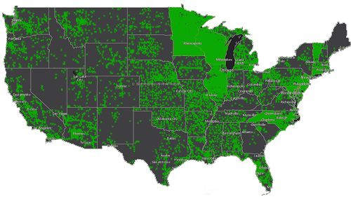
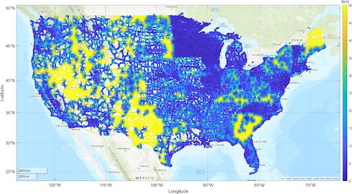
made great strides toward
their data coverage goals in
2021. Check out the
GPSonBM Progress
Dashboard to see how your
state is doing. If you are up
for a little competition (or
collaboration), check the
OPUS Shared Solutions
Dashboard to see who in your
state is submitting GPS data.
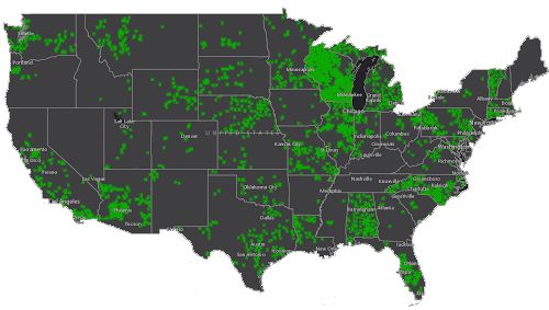
10 km hexagons completed in 2021

Opportunities in 2022
All of the green hexagons in the first map below show where we now have data for the
transformation tool. Despite all of this progress around the country, there are still areas
with large data gaps. By necessity, NGS will interpolate over areas without GPSonBM
data, meaning that the transformations will be less accurate in those areas. The final map
below shows remaining data gaps of 50km or more in yellow.

                              Total 10 km hexagons completed to date
Remaining Data Gaps: Yellow areas are data gaps of 50 km or more

Partners Helping to Get the Word Out
We’ve hit the ground running in 2022 with an outreach blitz that
has been greatly amplified by our partners across the country.
First, I had a great discussion about the value of collaboration on
mutually beneficial efforts with Tim Burch, the new Executive
Director of the National Society of Professional Surveyors, on his
podcast “Surveyor Says!” Check out our episode (#111) here at
surveyorsays.podbean.com. NGS looks forward to working
closely with Tim and the team at NSPS on getting our community ready for the
Modernized NSRS. Please consider getting your state surveying society and/or your local
chapter involved in a GPS on Bench Marks project (again) this year. If you get started
now, you could be ready to hold an event during Surveyor’s Week March 20-26. You can
also use such events to highlight the crucial role that surveyors play in all of the
infrastructure projects getting underway around the country.

Next out of the gate was Gavin Schrock’s excellent article in xyHt “GNSS on Bench
Marks?” Gavin expertly describes the value of the program, some of the challenges we
face in carrying it out, and the exciting developments that NGS is working on to improve
productivity. I was hooked by his epic opening line, “The GPS on Bench Marks
campaign of the National Geodetic Survey is a triumph of constituency participation
to improve the nation’s geodetic infrastructure.”

Finally, we were honored to kick off this year’s NGS Monthly Webinar Series with a
webinar titled GPSonBM: NSRS Modernization Campaign Continues through 2022,
featuring two inspiring guest stars, Mick Heberlein from Wisconsin DOT, and Jacob Heck,
the NGS Great Lakes Regional Geodetic Advisor. Mick and Jacob described how they
teamed up to encourage participants across the state to complete observations on nearly
all of the priority bench marks in Wisconsin in 2021. Follow their example and take
advantage of this extra year of data collection to prepare your communities to derive the
full suite of benefits from the Modernized NSRS to come!

NGS tracks participation in this campaign, but we rely on partner participation to be
successful. If you have an accomplishment you want to highlight, email
NGS.GPSonBM@noaa.gov.
NOAA's National Geodetic Survey
                geodesy.noaa.gov

Stay Connected with NOAA's National Ocean Service
              Manage Subscriptions
You can also read