Forgotten World Highway - Mountain Biking Difculty Hard - Walking Access ...
←
→
Page content transcription
If your browser does not render page correctly, please read the page content below
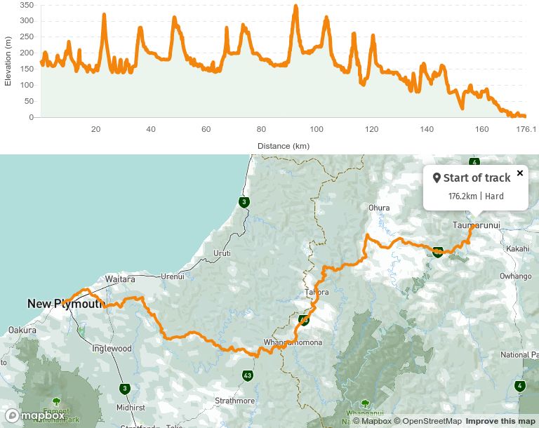
Forgotten World Highway Mountain Biking Dif culty Hard Length 176.2 km Journey Time 2 to 3 days cycling Region Taranaki Sub-Region New Plymouth Part of the Collection Nga Haerenga - The New Zealand Cycle Trail
Taumarunui — New Plymouth (2-3 days, 185km)
Pedal back in time and experience an amazing historical tour on New Zealand’s oldest
heritage trail.

The remote and mysterious Forgotten World Highway features mountain saddles, an eerie
tunnel and a river gorge.

The most signi cant settlement along the highway is Whangamomona, a historic town that
declared itself a republic in 1989 and sells its own passports.

There are plenty of places to stop, stretch your legs and explore historic sites and scenic
walks along the way.

New Plymouth Coastal Walkway
This award-winning 12.7km coastal walkway winds its way along the edge of the Tasman
Sea, past world-class surf breaks and dynamic kinetic art.

You can take a 15-minute stroll from the central city to Breakwater Bay, a bustling coastal
precinct alongside Ngamotu Beach.

The locals have created varied experiences here from the romantic to the adventurous.

Enjoy a coffee or dinner, cruise around the Sugar Loaf Islands or take a helicopter ight
over Mt Taranaki.

Breakwater Bay is also a great spot to see a stunning west coast sunset.

Whanganui River
The Whanganui River has a special place in the hearts of those who live in the region,
holding cultural, spiritual and historical signi cance in its murky depths.
Conditions:

This cycling route is remote.

There are only a few businesses providing accommodation or food along the way, so
cyclists must plan in advance and go well prepared.

The trail can be ridden year round, but the best riding conditions are in summer and
autumn (late November to early May).

It is rated Grade 4 (advanced), so it is recommended for t and experienced cyclists
only.

MOBILE PHONE COVERAGE: Limited between Taumarunui and Whangamomona and is
available along much, but not all of the way.

DRINKING WATER: There are a number of settlements where you can ll your water
bottle.
How to get here
All Trail Sections are Grade 4 Advanced
Taumarunui to Tahora Saddle (77km 5-8 hours)
Tahora Saddle to Purangi (45km 3-5 hours)
Purangi to New Plymouth (63km 4-6 hours)
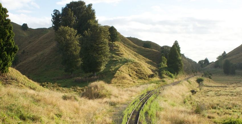
The Forgotten World Highway starts at Taumarunui, a railway town in the Central North
Island. The cycle route traverses the quietest state highway (SH 43) in New Zealand, with
approximately 200 cars on average using the main section per day.
After several kilometres, the route heads over hilly farmland for 30km before climbing over
Paparata Saddle. It then drops down into the beautiful Tangarakau Gorge, which is cloaked
with native forest.
This is followed by 15km of gravel road and although this is relatively smooth and road
bike tyres can usually cope, it is not always easy, especially when the road has just been
graded.
Beyond the gorge, there is a moderate climb to the Moki Tunnel (known locally as the
Hobbit’s Hole) and over Tahora Saddle followed by a long and gentle downhill ride to the
settlement of Whangamomona. This town not only celebrates its rich history but also
celebrates its claim to be an independent republic every second January.
Heading south from the ‘republic’, the route turns off the state highway and heads west on
Junction Road. The rst 16km of Junction Road is gravel and requires wide road tyres or
mountain-bike tyres. It is scheduled to be sealed before 2020.
Junction Road passes through several original settlements, including Purangi, where
accommodation is available in the original schoolhouse.
The road is narrow, quiet and scenic. This is kiwi country and you will need to watch out for
goats, sheep and cattle wandering along the verge.
The route continues over Tarata Saddle, through another picturesque tunnel, and down to
a historic suspension bridge across the Waitara River.
The ride leaves the very best for last, as the route now becomes a shared path through Bell
Block and around the coast where you will enjoy some spectacular views as you head into
New Plymouth.Track Elevation and Map Page last updated: Sep 9, 2020, 4:18 PM
You can also read