First fluvial archive of the 8.2 and 7.6-7.3 ka events in North Africa (Charef River, High Plateaus, NE Morocco)
←
→
Page content transcription
If your browser does not render page correctly, please read the page content below
www.nature.com/scientificreports
OPEN First fluvial archive of the 8.2
and 7.6–7.3 ka events in North
Africa (Charef River, High Plateaus,
NE Morocco)
Bruno Depreux1,2*, Jean‑François Berger3, David Lefèvre1,2, Quentin Wackenheim4,5,
Valérie Andrieu‑Ponel6, Sylvia Vinai2, Jean‑Philippe Degeai1,2, Abderrahmane El Harradji7,
Larbi Boudad8, Séverine Sanz‑Laliberté1,2, Kristell Michel9 & Nicole Limondin‑Lozouet4
The Early–Mid Holocene transition is a period of profound changes in climatic mechanisms and
hydrological features in Europe and North Africa. The melting of the Laurentide ice sheet led to an
oceanic and atmospheric reorganisation in the North Atlantic, while the Mediterranean underwent
a major hydrological shift. The impacts on Mediterranean rivers remain unclear, as there are few
records documenting responses to the 8.2 ka event (the main Holocene climatic degradation). We
present a fluvial record from Eastern Morocco documenting detailed hydrological variations from
8200 to 7500 cal. BP and their climatic forcing. A major hydrogeomorphic evolution of the Charef River
occurred at that time, marked by two major incision stages close in time, under hyper-arid conditions
at 8200 and ca. 7500 cal. BP. The impacts of these phenomena on the alluvial plains and associated
archaeological records during Neolithisation, a major process in human history, currently remain
unidentified. This new record sheds light on the fluvial response to the 8.2 ka event in North Africa
and why other records are missing. We also bring new insights into the hydrological disruption at the
Early–Mid Holocene transition, which was driven by the end of deglaciation combined with insolation
and solar forcing. Furthermore, centennial solar variability may have paced river activity in the
Moulouya basin and arid regions of North Africa.
The Early–Mid Holocene transition was a period of profound changes in climatic mechanisms and hydrologi-
cal conditions in Europe and North Africa. During the Early Holocene, orbitally-induced warming caused the
retreat of ice s heets1, notably melting of the Laurentide Ice Sheet (LIS), which was marked by sudden meltwater
outbursts. Climate variability was therefore paced by millennial-scale solar irradiance changes and meltwater
pulses, leading to Atlantic Meridional Overturning Circulation (AMOC) perturbations and the North Atlantic
cold event2,3. The Early–Mid Holocene transition is marked by the final disappearance of the LIS and its last
glacial lake outbursts: the major drainage of the Lake Agassiz-Obijway at 8470 cal. BP4 and a minor event at ca.
7500–7000 cal. BP5. These phenomena are thought to be the main factors behind the modification of oceanic
and atmospheric circulations over the North Atlantic, which led to the emergence of a North Atlantic Oscillation
(NAO)-like circulation pattern from the Mid-Holocene onwards in Europe and the M editerranean6,7.
The drainage of the Lake Agassiz-Obijway probably led to the so-called 8.2 ka cooling event, which is the most
well-known Holocene rapid climatic change (RCC), because it is the only one to be identified in the Greenland ice
cores and numerous archives w orldwide2. The hydrological impacts of the 8.2 ka event varied across Europe and
the Mediterranean basin, with a latitudinal partition of hydrological responses to long- and short-term climatic
1
Univ. Paul Valéry Montpellier 3, CNRS, UMR 5140 Archéologie des sociétés Méditerranéennes, Campus Saint
Charles, 34000 Montpellier, France. 2LabEx Archimède, Univ. Paul Valéry Montpellier 3, Campus Saint Charles,
34000 Montpellier, France. 3Univ. Lyon, Université Lumière Lyon 2, CNRS, UMR 5600 Environnement Ville Société,
69635 Lyon, France. 4Univ. Paris 1, UPEC, CNRS, UMR 8591 Laboratoire de Géographie Physique, 92195 Meudon,
France. 5Univ. Paris 1, CNRS, UMR 8215 Trajectoires, 75004 Paris, France. 6Institut Méditerranéen de Biodiversité
et d’Ecologie Marine et Continentale, Aix Marseille Univ., CNRS, IRD, Technopôle de l’Environnement
Arbois-Méditerranée, 13545 Aix‑en‑Provence, France. 7Univ. Mohammed 1er, Oujda, Morocco. 8Univ. Mohammed
V, Rabat, Morocco. 9Univ. Lyon, ENS de Lyon, CNRS, UMR 5600 Environnement Ville Société, 69342 Lyon,
France. *email: bruno.depreux@univ-montp3.fr
Scientific Reports | (2022) 12:7710 | https://doi.org/10.1038/s41598-022-11353-y 1
Vol.:(0123456789)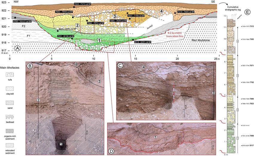
www.nature.com/scientificreports/
changes evidenced during the Holocene6. The 8.2 ka event resulted in wetter and colder conditions between
~ 50° to ~ 42°N, and drier conditions north and south of these latitudes8. These impacts are well evidenced in
marine9–11, lacustrine12, and speleothem records13,14, although surprisingly, the river responses to the 8.2 ka event
are actually rather unknown in Western Europe and the M editerranean15,16. The end of the 8th millennium BP
(ca. 8500–8000 cal. BP) is marked by high river stability in the UK17, and conversely, by high river activity in
Germany8. In the Mediterranean, the most comprehensive fluvial synthesis indicates that the 8600–7800 cal. BP
interval was marked by a common absence of flooding in southern France, southern Italy, the eastern Mediter-
ranean, Iberian Peninsula, Tunisia, and M orocco16. This is less significant for Iberia, as it is mainly based on slack
water deposits which cannot be correlated with alluvial plain records. A few detailed studies from the northern
Mediterranean shed light on the fluvial dynamics at that time. Two high-resolution palaeochannel records from
northern Greece and southern France demonstrate overall high fluvial activity related to the 8.2 ka event, marked
by a succession of coarse deposits, with braiding and fluvio-colluvial aggradation, and pedogenic development,
respectively, in the following c enturies18,19. A coarse-load flood deposit that eroded part of the Early Neolithic
Khirokitia archaeological site and led to spatial redistribution of the village is also noted in Cyprus19. The most
detailed record, located on an Early Holocene terrace in the apex of the Holocene alluvial fan of the Citelle River
in the Middle Rhone valley, shows overall increased fluvial activity over a millennium (8200–7100 cal. BP), before
an entrenchment after 7000 cal. BP, due to wetter climatic conditions related to the 8.2 and 7.6–7.3 ka R CCs18.
This archive mirrors the variations recorded by the Corchia and Renella speleothems from north-central Italy,
which indicate increased winter precipitation and torrential flooding in mountainous regions between 8200
and 7100 cal. B P20. In Spain, few detailed regional case studies present alluvial records for that time, indicating
regional floodplain aggradation around 8000–7300 cal. BP21. This refers to a recent study on the Galera River
which allows the construction of a coherent regional palaeoenvironmental scheme for SE Spain indicating
particularly wet conditions between 8000–7500 cal. BP, interrupted by dry e pisodes22. Regarding depositional
settings, there is a notable lack of Holocene flooding dates coming from palaeochannels15. Tunisian alluvial
syntheses also provide no evidence of any fluvial response to the 8.2 ka event, mirroring the long-unresolved
“missing event” in the SW Mediterranean23. As for Iberian records, it is interesting to see that Early Holocene
deposits as a whole are particularly u nderrepresented21,24, which may be partly a problem of dating strategies.
In Morocco, the Moulouya upstream rivers showed extensive wetland formation during the Early Holocene,
whereas downstream archives do not record alluvial deposits at that time25. The common sedimentary gap span-
ning from 8700 to 7300 cal. BP in the NE Moroccan fluvial records is indicative of the sedimentary “silence” that
characterises the Early–Mid Holocene transition in the Mediterranean rivers.
However, the new record from the Charef River in the North African High Plateaus (NE Morocco) revealed in
this paper sheds light on this issue. We present high-resolution chronostratigraphic and palaeoecological analyses
of this fluvial sequence from the main tributary of the Moulouya River, one of the largest Mediterranean river
basins (Fig. 1A). This record, spanning from 8200 to 7500 cal. BP, also brings new insights into the hydrological
disruption at the Early–Mid Holocene transition in the western Mediterranean.
Results
Geomorphology, sedimentology, and chronostratigraphy. The Cha07 fluvial record corresponds
to a palaeochannel infilling located in the riverbanks of the Charef River, the main tributary of the Moulouya
River, which drains the current arid High Plateaus region and the Ain Beni Mathar basin (Fig. 1B, Supplemen-
tary Fig. S1). The river section, intensively surveyed over a 2-km upstream–downstream section, shows several
nested alluvial formations spanning the Holocene (Fig. 1C). Fine wetland deposits (F2) accumulated in the
southeast part of the river section, and are developing eastwards, whereas there is an underlying carbonated
massive sands (F1) outcrop in the northwest part (Fig. 1C). F2 corresponds to the climate-driven extensive Early
Holocene formation recognised in the upper and middle reaches of the Moulouya catchment25. Owing to the
current entrenchment of the river bed, a palaeochannel (Cha07 outcrop) cutting into F1, F2, and the Red Mud-
stone formation was identified (Fig. 2A). More details about the different Holocene formations identified in the
area are given in the Supplementary Information.
The 18-m-wide palaeochannel shows a 6-m-thick infilling composed of alternating coarse and fine sediments
(Fig. 3). The time span encompassed by the Cha07 record is constrained by eight radiocarbon dates ranging from
8150 to 7500 cal. BP (Supplementary Table S1). A rapid succession of aggradation and small incision phases is
evidenced by several nested channel deposits, implying strong energy variations of the active channel and strong
lateral and vertical mobility (Fig. 2B,C). This channel shows a polyphase activity with four different cycles accord-
ing to morphology, incisional features, and sedimentology, and will be described hereafter as fluvial sequences
(Figs. 3 and 4). All the sequences are nested into the previous deposits, and present sedimentary graded bedding
with channel bed load deposits at the bottom (coarse pebbles to cobbles), grading upwards into finer particles
(silt and clay). This upwards-fining trend indicates a progressive decrease in flow energy within a channel deposit.
These fluvial sequences indicate four periods of aggradation dated around 8116–7999 (S-1), 7923–7886 (S-2),
7762–7671 (S-3) and 7585–7515 cal. BP (S-4), which are separated by erosive phases of the previous deposit
over 1.5–2 m . No such fluvial archive was found in North Africa, which makes this record a rare opportunity to
document hydrological and climatic changes during the Early–Mid Holocene transition. Indeed, the chronology
of this archive perfectly fills a sedimentary hiatus generalised to the whole alluvial archives of NE Morocco, which
extends from 8700 to 7300 cal. BP25 (Supplementary Fig. S6). This lack of alluvial records has long prevented an
understanding of the response of hydrosystems to the 8.2 ka climatic event, which remained totally unknown23.
The incision I-1 of the Cha07 palaeochannel into F2 and F1 down to the Red Mudstone formation indicates
a major downcutting phase ca. 8200 cal. BP of at least 4 m as organic-rich fluvio-palustrine deposits suggest a
water table level at 921 m a.s.l. (Fig. 3A,D). Indeed, the top of what is preserved of the Early Holocene F2 deposits,
Scientific Reports | (2022) 12:7710 | https://doi.org/10.1038/s41598-022-11353-y 2
Vol:.(1234567890)
www.nature.com/scientificreports/
Figure 1. Geographical setting. (A) Location of the studied area and the references discussed in the
Mediterranean basin (the numbers refer to the studies referenced in the text), and (B) within the topographic
frame of NW Africa. (C) Geomorphological map of the superficial sedimentary formations of the studied
section of the Charef River. EH Early Holocene, MH Mid-Holocene, LH Late Holocene. Data source and
software: (A) data from TerraColor imagery (https://www.arcgis.com/home/item.html?id=10df2279f9684e4
a9f6a7f08febac2a9), (B) data from ASTER GDEM2 (https://lpdaac.usgs.gov/products/astgtmv002/) both plotted
by means of ArcGIS Pro [2.7] (https://www.esri.com/en-us/arcgis/products/arcgis-pro/), (C) map created by B.
Depreux using Adobe Illustrator CC (https://www.adobe.com/).
strongly eroded by the palaeochannel Cha07, was dated to 9700–10,157 cal. BP. These F2 deposits correspond to
the regional-scale wetland formation, documented within the Tabouda River, the main tributary of the Charef
River, and in the Ksabi basin in the Middle Moulouya (Supplementary Fig. S1). The study of these alluvial
deposits, highlighting the similarities and synchronies of fluvial dynamics and topogeomorphological positions
between these two basins, which are more than 300 km apart, has shown a strong homogeneity of hydrosedi-
mentary dynamics and morphogenesis at the regional scale. This wetland formation, which we assume to reflect
the orbitally-induced African Humid Period (AHP), demonstrates the high sensitivity of these catchments and
North African highlands to climatic forcing25. In all the deposits studied, and in both basins, this formation is
truncated. The most recent date was obtained from the Tab01 outcrop, not far from the Charef River (Supple-
mentary Fig. S1), and confirms the development of this formation until at least 8910 cal. B P25.
Following I-1, the first sequence (S-1) exhibits a 1-m-thick bed load deposit defined by nested coarse pebbles
(1.6–6.4 cm) to cobbles (6.4–25.6 cm) interstratified with laminated silty beds and dismantled Early Holocene
sediments (Supplementary Fig. S8). The channel deposit ends with alternating sands and granules to clayey
units. S-2 presents a 1-m-thick homogeneous and monogenetic bed load deposit, then well-sorted horizontal
sandy and silty beds (Fig. 3B). This channel infilling ends with tufaceous sandy silts that include complete Poto‑
mida littoralis bivalves. In both sequences, several polyhedral clayey beds marked by desiccation cracks indicate
episodes of drying up with an absence of discharge. Sequences 3 and 4 present slightly different sedimentary
features. S-3 shows a 2-m-thick gravel aggradation interstratified with sandy and silty beds marked by the pres-
ence of reworked tufa tubes and rolled clay pebbles. Then, a lateral accretion and displacement of the channel
towards the southeast, characterised by cross-bedded sands, indicates more lasting channel activity between
7800 and 7675 cal. BP (Fig. 3C). This sequence ends with a 60-cm-thick tufa deposit including numerous tubes
Scientific Reports | (2022) 12:7710 | https://doi.org/10.1038/s41598-022-11353-y 3
Vol.:(0123456789)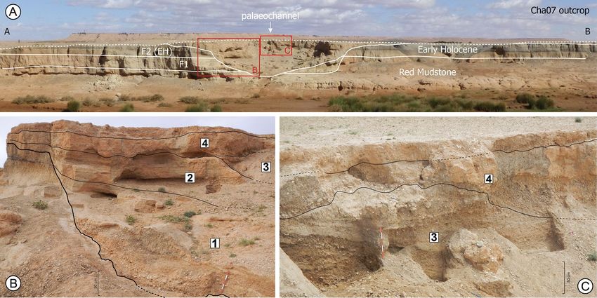
www.nature.com/scientificreports/
Figure 2. (A) Overview of the Cha07 outcrop, showing the Cha07 palaeochannel record and its incision into
F2, F1, and the Red Mudstone formation. (B,C) Views of the palaeochannel infilling showing the limits and
numbers of the fluvial sequences. The palaeochannel does not present a straight outcrop but has been hollowed
out by erosion and has a platform at the top of the sequence 1. Data source: (A–C) pictures from D. Lefèvre, J.-F.
Berger, and B. Depreux, respectively.
Figure 3. (A) Transverse section across the Cha07 palaeochannel infilling showing the main litho-stratigraphic
units, positions of radiocarbon datings (2σ cal. BP), and underlying formations: Early Holocene F2, pre-
Holocene F1, and Red Mudstone formation. (B–D) Detailed views of parts of the palaeochannel infilling
with stratigraphic units. (E) Cumulative stratigraphic log with litho-sedimentary units grouped into fluvial
sequences. Data source and software: drawing by B. Depreux using Adode Illustrator CC (https://www.adobe.
com/), and pictures from B. Depreux and J.-F. Berger.
Scientific Reports | (2022) 12:7710 | https://doi.org/10.1038/s41598-022-11353-y 4
Vol:.(1234567890)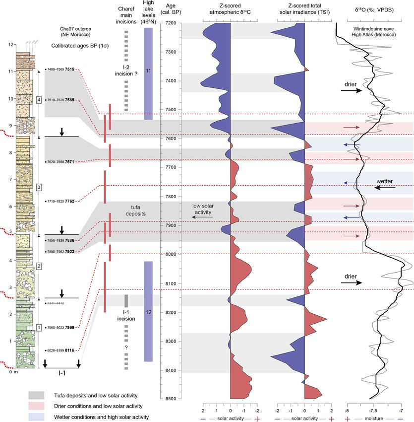
www.nature.com/scientificreports/
Figure 4. Synthetic results from the stratigraphic, sedimentological, malacological, and pollen analyses of the
Cha07 palaeochannel infilling.
and complete Potomida littoralis. Above its bedload deposit, S-4 does not exhibit rhythmic sand and silt layers,
only a 1.7-m-thick tufa sedimentation reflecting reduced discharge and stabilisation at the basin scale, as for
the top of S-2 and S-3. The last deposit dated to 7500 cal. BP, which covers the top of the palaeochannel with a
poorly sorted layer (gravel to silty fractions), does not provide evidence of channel formation, but a mixed flood
deposit implying that the channel has migrated.
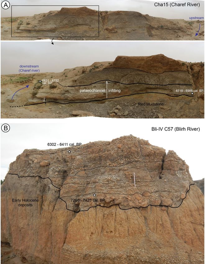
Apart from the Cha07 palaeochannel studied here, only two other palaeochannels have been identified in the
upstream basins of the Moulouya. The first is located 1.5 km upstream of Cha07, on a small tributary 10 km long
of the Charef River (Supplementary Fig. S1). The second is located in the Blirh River in the middle Moulouya,
300 km away. Both records show a similar pattern of incision into the Early Holocene formation and the Red
Mudstone formation. In contrast to Cha07, the entire palaeochannel section is not preserved, but only one of
the lateral edges in a proximal position. The first (Bli-IV C57) shows the succession of bedload and travertine silt
deposits between 7350 and 6350 cal BP (Fig. 5B). The incision thus slightly pre-dates 7350 cal. BP. The second
(Cha15) is less well dated, showing a silty-sandy fill, sometimes tufaceous and rich in malacofauna (Fig. 5A). Two
dates were made at two different locations in the centre of its fill and give ages between ca. 7000 and 6650 cal.
BP. These data show a regional incision phase before 7350 cal. BP, and thus confirm firstly the existence of the
Scientific Reports | (2022) 12:7710 | https://doi.org/10.1038/s41598-022-11353-y 5
Vol.:(0123456789)
www.nature.com/scientificreports/

                                            Figure 5.  Views of the two other partially eroded palaeochannels identified in the Moulouya’s upstream basins.
                                            (A) The Cha15 outcrop located 1.5 km upstream of Cha07, on a small tributary 10 km long of the Charef River,
                                            (B) the Bli-IV C57 outcrop located in the Blirh River in the Ksabi basin (middle Moulouya).

          Scientific Reports |   (2022) 12:7710 |               https://doi.org/10.1038/s41598-022-11353-y                                                6

Vol:.(1234567890)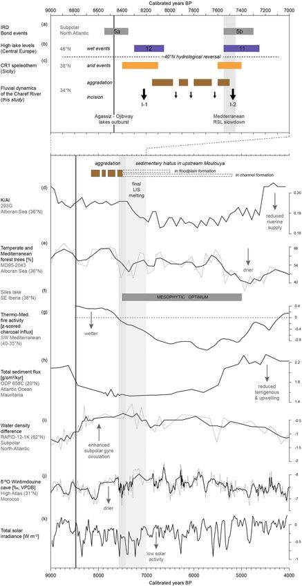
www.nature.com/scientificreports/
I-2 incision between 7500 and 7400 cal. BP, as assumed by the Cha07 archive, and secondly, the role of external
climatic forcing on the avulsion and palaeochannel formation processes.
These signatures are indicative of a rapid geomorphological evolution of the Charef floodplain occurring
after a multi-millennial period of stability (the Early Holocene wetland formation25). The channel trajectory
at the western edge of the Early Holocene alluvial plain, marked by a SW–NE palaeocourse, evidences a river
migration towards the northwest. This migration was not progressive, but rather involved channel avulsion due
to very high discharge increases and fast channel aggradation. This north-westward migration appears to have
continued as evidenced by Mid to Late Holocene deposits (F3–F4), including channel deposits at the base of
F3 along the present valley axis (Supplementary Fig. S2), and the present course of the Charef River (Fig. 1C).
Palaeoecology. The malacofauna of the Cha07 record comprises a high proportion and diversity of fresh-
water molluscs and fewer terrestrial snails, which reflects the local environmental conditions of the channel
bottom and the river bank. The molluscan succession can be divided into three biozones (MZ1, MZ2a&b, MZ3)
based on ecological patterns (Supplementary Fig. S9) and the occurrence and development of taxa (Supple-
mentary Fig. S10). The assemblages from Malacozone 1 indicate a dominantly aquatic environment with few
adjacent palustrine areas and sparse xeric vegetation. From 7950 cal. BP onwards, Malacozone 2 records strong
fluvial dynamics that affect the sustainability of the terrestrial environments. The stability of the terrestrial envi-
ronments suggests the development of wetland areas near the channel whereas dynamic fluvial conditions would
prevent the establishment of adjacent marshy habitats. From 7850 to 7700 cal. BP, habitat instability is par-
ticularly pronounced, and corresponds to the sub-zone MZ2b. Molluscan assemblages in Malacozone 3 reflect
the predominance of aquatic environments. However, after 7700 cal. BP, the adjacent riverbanks stabilise and
small wetlands develop surrounded by xeric vegetation in the channel zone. The palaeoenvironmental scheme
obtained from mollusc assemblages supports the lithostratigraphical data.
The vegetation patterns evidenced by the pollen analysis indicate a sparsely wooded landscape dominated
by a steppe of Poaceae, sagebrush, and Chenopodiaceae (Supplementary Fig. S11). At the bottom of the record,
perennial water bodies in the bed of the Charef River allow the existence of a population of Myriophyllum, the
presence of tall grasses (Sparganium/Typha) along the banks, and a riparian forest dominated by Salix. This
environment was propitious for herds of large herbivores to come and drink. The climate then became drier, as
indicated by the domination of Chenopodiaceae steppe over the Artemisia and Poaceae steppe that previously
prevailed. The disappearance of the riparian forest is consistent with the aridification of the climate. This event
is dated between 7866–7972 and 7931–8158 cal. BP. At the top of the pollen record, the climate becomes wetter,
as indicated by the recovery of Artemisia and Poaceae steppe and a new phase of colonisation of the river banks
by a riparian Tamarix forest. Fire signals dated to between 7835 and 7972 cal. BP could be either of natural or
anthropogenic origin. The question of agricultural signals arises because pollen of cereals and nitrophilous plants
and spores of coprophilous fungi have been recorded for dates between 7931–8158 and 8018–8291 cal. BP. These
could be fleeting signs of human occupation and the presence of grazing animals, not necessarily domesticated;
it is possible the appearance of cereals is natural and results from biotic interactions between the steppe and large
wild herbivores, without human involvement being necessary, as has been shown in Turkey26. Hunter-gatherer
populations and herds of large mammals may have benefited from the potentially edible plants present in the
vegetation (Supplementary Fig. S11), particularly cereals, which are rich in carbohydrates and very nutritious.
Discussion
The missing event: the 8.2 ka event in the Mediterranean and arid North African rivers. While
drier conditions seemed to result in higher geomorphic stability in northern European rivers17,27, what impact
did the 8.2 ka RCC have on river responses in the southern Mediterranean and (semi-)arid North Africa? How
do we explain the Mediterranean-scale paucity of fluvial deposits for this time?
In the upstream Moulouya basin, no deposits apart from the Cha07 palaeochannel record have been dated
to this period, regardless of the sedimentary facies (channel bed, overbank, hydromorphic, or pedogenic sedi-
ments). This sedimentary gap also concerns the entire alluvial record of NE Morocco, which extends from 8700
P25, and North Africa as a w
to 7300 cal. B hole23. We can therefore question why such intense fluvial activity does
not leave any flood deposits preserved in the floodplains. In this study, we assume that the 8.2 ka RCC had a
major hydrological impact in North Africa, marked by increased river activity, and that taphonomic conditions
are a key to understanding the sedimentary hiatus at that time.
Climate forcing is indeed the most likely cause because of the good correlation with the regional palaeo-
climatic record, discussed below, and the regional character of the observed changes. Furthermore, the role
of other factors is not convincing. Archaeological data is almost non-existent in the region, apart from a few
rare and isolated studies. Human settlement is therefore unknown in the upstream basins of the Moulouya
eriod28. Even on the Mediterranean coast, the period corresponds to a hiatus in the archaeological
for this p
sequences at the Epipaleolithic-Neolithic transition29. On the basis of pre-existing data, it is difficult to imply
that the anthropogenic factor is responsible for hydrogeomorphological dynamics representative of the upstream
basins. Regarding tectonics, the High Plateaus, belonging to the Eastern Mesetian domain, are not affected by
either the Atlasic orogeny (Jurassic and Eocretaceous in age) or the Cenozoic Rifan o rogeny30. No evidence of
neotectonics has been identified in the Holocene (or older) sedimentary formations, so it does not appear to be
active during this period. Thus, the lack of fluvial responses to the 8.2 ka RCC in the southern Mediterranean
and concurrent with the exceptional hydrological conditions recorded in the Charef River are not down to mere
coincidence. This assessment is supported by other aforementioned detailed channel records from the northern
Mediterranean18,19 (Fig. 6).
Scientific Reports | (2022) 12:7710 | https://doi.org/10.1038/s41598-022-11353-y 7
Vol.:(0123456789)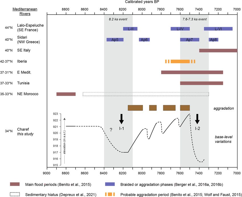
www.nature.com/scientificreports/
Figure 6. A synthesis of river activity in the Mediterranean at the Early–Mid-Holocene transition, including
the main flood periods in SE Italy, Iberia, eastern Mediterranean, Tunisia, and M orocco16, the sedimentary
gap in NE Moroccan rivers from 8700 to 7300 cal. BP25, indices of aggradation in I beria21, the braided phases
identified at Lalo-Espeluche18, the aggradation phases identified at S idari19, and the base-level variations of the
Charef River with the I-1 and I-2 incision phases and the four aggradation phases.
The Cha07 record demonstrates that the drier conditions of the 8.2 ka RCC, followed by wetter conditions,
resulted in strong hydrosedimentary dynamics marked by severe river incision (I-1), high-flow discharge, and
coarse bedload transport and deposition. Indeed, fluvial dynamics in (semi-)arid environments respond in a
different way to precipitation fluctuations, and river incision, when climate forcing is involved, appears to be
caused more by high-energy discharges and by a transition from arid to wet c onditions31. For the Charef River,
incision accompanied by coarse fluvial deposits indicates highly unstable landscape conditions and strong liq-
uid discharges that may reflect the transition from drier to wetter conditions. A common pattern is that arid
conditions reduce vegetation cover and soil infiltration capacity, leading to increased soil erosion and surface
runoff32. A Horton-type overland flow characterised by an excess amount of water that bare soil cannot absorb
is common in such environments where precipitation patterns favour scarce but intense rainfall. Indeed, NW
Africa, excluding Atlantic Morocco, is subject to spring to summer precipitations due to cyclogenesis and con-
vective storms33. This pattern explains the general trends in floodplain sediment aggradation in (semi-)arid river
systems in relation to drier conditions21.
These strong hydrosedimentary dynamics led to the erosion and removal of previous alluvial deposits, as
evidenced by the common sedimentary gap spanning from 8700 to 7300 cal. BP in the NE Moroccan fluvial
records25. Moreover, the first evidence of sedimentation after the last Cha07 channel (S-4) is a channel deposit
of F3 dated to 4855–5231 cal. BP (Cha08 outcrop) located 700 m downstream and incising the Red Mudstone
formation below the present base level (913 m a.s.l., Supplementary Figs. S4 and S7). The difference in eleva-
tion between the last channel deposits of Cha07 (S4, dated ca. 7600 cal. BP) and Cha08 (dated ca. 5000 cal. BP)
is 8 m (Supplementary Figs. S3 and S4). If the present slope of the thalweg (− 1 m) is removed, a drop in base
level of 7 m is recorded between 7600 and 5000 cal. BP. This sedimentary hiatus in the Charef River from 7500
Scientific Reports | (2022) 12:7710 | https://doi.org/10.1038/s41598-022-11353-y 8
Vol:.(1234567890)www.nature.com/scientificreports/
to ca. 5000 cal. BP thus reveals a long-term entrenchment of the river bed, which probably contributed to post-
depositional erosion of alluvial deposits related to the 8.2 or 7.6–7.3 ka events. This has partially preserved the
F2 formation, as it is largely developed within the alluvial plain, while the alluvial deposits related to the 8.2 and
7.6–7.3 ka events, of a different nature (palaeochannels), and in a proximal position in the axis of the valley,
have been eroded by incision accompanied by vertical and lateral bank erosion. We therefore postulate that the
P23 stems from strong post-depositional erosion and the
lack of alluvial deposits in North Africa ca. 8200 cal. B
predominance of coarse fluvial deposits resulting from increased channel dynamics and erosional processes.
Palaeochannels, as an alluvial archive, are underrepresented in such environments, especially as they are located
in the river stream and are therefore often completely removed by later erosional processes.
Besides alluvial deposits, these taphonomic conditions have impacted the preservation of archaeological
remains. Recent probability distributions of 14C dates from archaeological sites, interpreted as demographic
indicators, show a gap in archaeological deposits between 8600 and 7600 cal. BP. Explanations for this gap include
a collapse in continental sites with a moving to coastal areas within the Eastern Rif–Lower Moulouya a rea29,
and a decrease in human population with two significant peaks at 8400 and 8100 cal. BP at a Moroccan s cale34.
With mobility being one of the adaptive abilities of societies and being probable in such contrasting geographical
settings forming a mosaic of environments, taphonomic processes should be taken into account, as floodplain
open-air sites would have been eroded and removed during this period of fluvial instability35. We believe that
interpretations of the amount of archaeological radiocarbon dates as human population decreases should be
qualified by considerations of local settlement relocation and sedimentary taphonomic effects.
Hydroclimatic shifts during the 8th millennium: forcing and taphonomic effects. A long‑term
fluvial instability at the EH–MH transition. The timing of hydrosedimentary changes such as those at the Ear-
ly–Mid-Holocene transition still need to be discussed. The first major incision (I-1) is marked by a downcutting
of at least 4 m and widespread erosion of the top of F2 (Fig. 6). This incision is responsible for a sedimentary
hiatus from 8900 to 8150 cal. BP, probably due to the transition from the drier conditions that prevailed dur-
ing the 8.2 ka RCC in the SW Mediterranean to the return to wetter conditions13,14 (Fig. 7). Such causality was
already suggested for the Sahelian belt, where, at the same time, a major incision of the Yamé valley associated
with a sedimentary hiatus occurred between 8760–7800 cal. BP31. Then, four periods of aggradation marked
lasting fluvial instability up to 7500 cal. BP. This period ends with a second major incision (I-2), assumed by the
Cha07 archive and recognised in two other records, which occurred between 7500 and 7400 cal. BP and which
cut into the Cha07 infilling. Its regional extent confirms the role of external climate forcing on the processes of
avulsion and paleochannel formation. This event is probably related to the 7.6–7.3 ka RCC. Indeed, this RCC,
which seems to have followed a similar hydrological pattern to the 8.2 ka event at a Mediterranean scale, with
drier anomalies recorded south to 40°N36, could be linked to the last of the proglacial lake outbursts into the
Atlantic and the final melting of the LIS5, and a grand solar minimum37. Both major incisions correspond to ice-
rafted debris (IRD) peaks (5a and 5 b3), mid-European high lake levels38, and δ18O depletion in the speleothem
record from the Carburangeli cave in S icily13 (Fig. 7). In general, the Cha07 record shows very good correlations
with the high-resolution palaeoprecipitation record in the High Atlas14: the filling of the palaeochannel occurred
during a wet period, preceded and followed by the two incisions I-1 and I-2 corresponding to the arid conditions
of 8.2 and 7.6–7.3 ka RCCs (Fig. 8).
During this interval, palaeoecological analyses document rather stable conditions during the fluvial sequence
S-1, with the presence of tall grasses and riparian forest (8150–7975 cal. BP, Fig. 4). Less stable and drier condi-
tions are noted during S-2 (7925–7850 cal. BP). Lasting hydrological activity (S-3) marked by dynamic fluvial
conditions and habitat instability in the malacological record is evidenced between 7800 and 7700 cal. BP (Fig. 4,
Supplementary Fig. S10), while pollen data marks the return of riparian forest (Supplementary Fig. S11). These
features may result from increased water availability and durability in the channel, which is coherent with the
centennial wetter climatic conditions recorded in the Alboran Sea MD95-2043 site ca. 7900–7700 cal. B P11, the
10
southern Adriatic Sea MD90-917 site at 7800–7700 cal. B P , the contrasting drier conditions recorded in the
Alpine lake l evels38, and a higher fire regime in the pre-Alpine catchments at 7800–7700 cal. B P18. The develop-
ment of a thick tufa deposit filling the channel ca. 7600–7500 cal. BP implies continuous but reduced flow energy
(Fig. 4). Tufa precipitation is associated with the development of a persistent population of Potomida littoralis,
which prefer calcareous waters, and whose well-preserved shells indicate low energy stream conditions (Sup-
plementary Fig. S10). At the same time, the higher diversity and slight increase in xerothermic molluscs indicate
sclerophyllous vegetation on adjacent river banks.
Interestingly, several western Mediterranean records evidence a climatic shift ca. 7500 cal. BP, which is
consistent with the second I-2 incision in Moulouya at that time (Figs. 5 and 6). While the centennial-scale
7.6–7.3 ka RCC induced drier conditions in the southern Mediterranean and A frica11,14,36, on the millennial
scale, it is followed by a long-term climatic amelioration. Indeed, wetter conditions are evidenced by thermo-
Mediterranean low fire activity south of 40°N from 7500 to 5000 cal. BP39 and a mesophytic optimum in SE
Iberia ca. 7500–5200 cal. BP12 (Fig. 7). This vegetation response is identified in the Alboran Sea MD95-2043
record, where, after a decline due to the 7.6–7.3 ka RCC, temperate and Mediterranean forest remains high up to
5400 cal. BP11. The nearby 293G site records a lasting drop in riverine supply from 7400 to 4500 cal40. Similarly,
several phases of floodplain stability are evidenced in Iberian rivers, with regional soil formation in the course
of the 7th and 6th millennia21. These indices demonstrate clear afforestation and increasing floodplain stability
associated with the return of humid conditions ca. 7500 cal. BP and their persistence until ca. 5000 cal. BP in the
southern Mediterranean, processes coherent with the orbital-scale AHP conditions prevailing in the Moulouya
basin25. These indices also reflect the sedimentary hiatus in the floodplain deposits of the upstream Moulouya
archives from 7500 to 6500 cal. BP, and from 7500 to ca. 5000 cal. BP in channels within the river bed (Fig. 7).
Scientific Reports | (2022) 12:7710 | https://doi.org/10.1038/s41598-022-11353-y 9
Vol.:(0123456789)www.nature.com/scientificreports/
Figure 7. Palaeoenvironmental and palaeoclimatic proxies. (a) Stacked ice-rafted debris e vents3, (b) mid-
European high lake levels38, (c) δ18O depletion from the CR1 speleothem record at the Carburangeli cave
in Sicily13, (d) K/Al ratio at the 293G site in the Alboran S ea40, (e) temperate and Mediterranean forest trees
at the MD95-2043 site in the Alboran Sea11, (f) mesophytic optimum at the Siles lake in SE I beria12, (g)
thermo-Mediterranean fire activity in SW M editerranean39, (h) total sediment flux at the ODP 658C site off
Mauritania46, (i) water density difference at the RAPID-12-K site in the subpolar North A tlantic44, (j) δ18O from
the speleothem record at the Wintimdouine cave in M orocco14, (k) total solar insolation (TSI, W m −2) derived
from 14C and 10Be radionuclides37.
Scientific Reports | (2022) 12:7710 | https://doi.org/10.1038/s41598-022-11353-y 10
Vol:.(1234567890)www.nature.com/scientificreports/
Figure 8. Comparison of the Charef record with mid-European high lake levels38, the speleothem record from
the Wintimdouine cave in the High A tlas14 (δ18O values in grey, and moving average over 13 points following a
5-year resampling in black using Analyseries software), and the main solar proxies: Z-scored δ14C values52 and
total solar insolation (TSI, W m−2) derived from 14C and 10Be radionuclides37.
In this respect, we assume predominant effects of an insolation-driven wetter climate and subsequent veg-
etation response coupled with an initial incision during the drier 7.6–7.3 ka RCC. Indeed, the development
of vegetation cover would have stabilised hillslopes and river banks, thereby preventing erosion and runoff.
Alluviation would be reduced because of the weaker sediment yield, and possibly constrained within the stream
bed because of the entrenchment of the river, before being washed out by floods. Unfortunately, palynological
studies for this period are not available for the High Plateaus region. Comparisons with the Middle-Atlas records
should be performed with caution, because elevation becomes the principal factor. Nevertheless, expansion of a
conifer/sclerophyllous mixed forest ca. 7000 cal. BP is recorded at the Tigalmamine and Ait Ichou lakes (~ 1620
and 1560 m a.s.l.), whereas it appears later at ca. 6300 cal. BP at the Sidi Ali lake (~ 2080 m a.s.l.)41,42.
Moreover, it has been noted that particularly strong incision occurred during the transition from dry peri-
ods to more humid ones because of a weakening of landscape stability followed by increasing p recipitation31.
This pattern is particularly relevant in the Moulouya basin, where stronger incision during the 7.6–7.3 ka RCC
Scientific Reports | (2022) 12:7710 | https://doi.org/10.1038/s41598-022-11353-y 11
Vol.:(0123456789)www.nature.com/scientificreports/
occurred under centennial drier conditions followed by a return to wet AHP conditions. This view is supported
by the identification of a flooding deposit ca. 7400–7300 cal. BP at the bottom of the Djamila outcrop in Lower
Moulouya43, which is followed by soil formation. These particular conditions could also explain the widespread
flooding period ca. 7500–7100 cal. BP across the M editerranean16.
Holocene deglaciation, insolation, and solar forcing. We see that this prolonged fluvial instability at the Early–
Mid Holocene transition mirrors a complex major hydrological change in the northern hemisphere at ca. 8000–
7000 cal. BP6. Three main forcing mechanisms have been suggested: orbital-driven insolation, end of deglacia-
tion, and solar activity. The final LIS disappearance was marked by the last proglacial lake outbursts into the
North Atlantic during this interval, and the subsequent rise of the RSL at 7600 cal. B P5, probably inducing the
Mediterranean RSL slowdown from 7500 cal. BP onwards44. Thus, the melting of the LIS altered the AMOC and
NAO-type atmospheric circulation, favouring a reorganisation of the Icelandic Low and Azores high pressure
cells, which led to a northward movement of westerlies during the Early–Mid Holocene transition7. This shift is
supported by the northward migration of the Azores f ront45, reduced coastal upwelling off western Africa46, and
intensification of the subpolar gyre c irculation47 that started ca. 8500–8000 cal. BP (Fig. 7). The Charef fluvial
instability and major hydrological change also coincide with a lasting decrease in solar activity, called the grand
solar minimum, which is indicated by 14C and 10Be radionuclides from tree-ring and ice-core records37.
Throughout the Holocene, the effect of solar forcing on climate variability is evident. Clear correlations
between solar activity, monsoon strength, North Atlantic IRD events, and the El Niño–Southern O scillation3,48
have been identified for the Early Holocene. Studies in north-central Europe indicate a major solar impact on
continental hydroclimatic conditions during deglaciation, with concurrent reduced solar activity and meltwater
pulses49. In this manner, during the 8.2 and 7.6–7.3 ka RCCs, the last outbursts and simultaneous decreases
in solar activity were concurrent with wetter conditions to the north and drier conditions to the south of the
western and central Mediterranean due to the enhanced strength of the Atlantic westerlies6,27. With the end of
deglaciation, climate variability appears more complex after 7000 cal. BP, because of regulation by oceanic and
atmospheric circulation patterns11. During the Mid and Late-Holocene, solar forcing and NAO-like atmospheric
variability could be the prominent factors driving centennial-scale climatic events in the Mediterranean area6.
Indeed, wetter conditions evidenced by enhanced flooding and lake-level highstands at mid-latitudes, and associ-
ated with IRD events and low solar activity, are in accord with NAO-type contrasting hydrological p atterns3,27.
This assumption is supported by high-resolution records that demonstrate direct solar forcing on hydrological
conditions in central Europe, i.e., a southward shift of the North Atlantic storm tracks that resulted in increased
rainfall during the Homeric solar minimum (ca. 2700 cal. BP)50. This solar-atmosphere linkage is thought to be
induced by the so-called ‘top-down’ feedback mechanism proposed by modelling s tudies51, which suggest that
important changes in UV radiation disturbed the stratospheric polar vortex and tropospheric jet streams, which
finally affected the Hadley Cell circulation and strength and location of North Atlantic storm tracks.
The high-resolution Cha07 record provides detailed information on hydrological responses of the river catch-
ment to climatic variations between the 8.2 and 7.6–7.3 ka RCCs. Our fluvial record suggests a probable forcing
of short-term solar variability on the Moulouya river activity during this interval. Indeed, the centennial to
multi-decadal variations in paleoprecipitation recorded in the High Atlas14 are very well correlated with fluc-
tuations in solar activity (TSI)37,52 (Fig. 8), which implies the role of solar forcing on the rainfall regime in the
region. These variations follow the De Vries-Suess (~ 210 yr) and Gleissberg (~ 90 yr) cycles, which are both tied
to solar v ariability51, and are recognised as modulators of flood frequency in central E urope53,54. In Morocco,
high-resolution records from the Middle Atlas also suggest solar forcing of hydrological changes through the
identification of the De Vries-Suess c ycle55. We show that the Cha07 tufa deposits are contemporaneous with
phases of low TSI and slight decreases in precipitation (Fig. 8). Within the highly dynamic channel environment,
we suggest that these tufa deposits should be interpreted as phases of stability that reflect reductions in solid
and liquid discharges, linked to multi-decadal decreases in rainfall in the High Atlas and solar activity, knowing
that the general humid climatic conditions between the 8.2 and 7.6–7.3 ka RCCs are met for the construction
of tufa deposits. We hypothesise that, at the Early–Mid Holocene transition, the hydrosedimentary dynamics
of the Charef River were paced by solar variability through a top-down mechanism. The short-term shrinking
of the Hadley Cell and southward location of the North Atlantic storm tracks could have also favoured cyclo-
genesis over NW Africa, leading to more-intense convective storms on the High Atlas and the subsequent rapid
hydrogeomorphologic changes recorded in the Charef River. This view could be related to the Mar Menor record
in SE Iberia, which demonstrates Mid–Late Holocene storm events coincident with cold periods, and suggests
that cyclogenesis variability was related to both AMOC and solar forcing56.
Ultimately, our record supports the end of deglaciation coupled with orbital-driven decreases in summer
insolation and solar activity variations as the main forcings to explain the millennial hydrological instability
in the western Mediterranean. Such relationships raise questions about the role of grand solar minima on the
hydroclimatic variability since the Early–Mid Holocene transition. Moreover, we point out the necessity of
investigating river catchments at different spatial and temporal scales, even at very high temporal resolution, to
perceive millennial to multi-decadal hydrological changes.
Conclusion
After multi-millennial stability during the Early Holocene, the Cha07 palaeochannel record demonstrates rapid
geomorphological evolution of the Charef floodplain ca. 8200–7500 cal. BP, marked by high channel activity and
major river incisions. This long-term fluvial instability sheds light on the concurrent sedimentary hiatus in NE
Moroccan alluvial deposits and the lack of preserved records in North Africa, addressing these long-unresolved
issues. The roles of two Rapid Climatic Changes (RCCs), i.e., the 8.2 ka and 7.6–7.3 ka events, are highlighted.
Scientific Reports | (2022) 12:7710 | https://doi.org/10.1038/s41598-022-11353-y 12
Vol:.(1234567890)www.nature.com/scientificreports/
We confirm that RCC-induced drier climatic conditions, followed by wet conditions, led to enhanced fluvial
activity in the Moulouya basin, and probably also in other arid environments in North Africa.
Furthermore, we document that the global-scale 8.2 ka event, which was surprisingly missing from southern
Mediterranean fluvial records, had a prominent impact on the Moulouya river system. We suppose that the
absence of river responses to this RCC in other fluvial syntheses stems from the major disruption of the 8.2 ka
event on North African river systems. The widespread flooding period ca. 7500–7100 cal. BP across the Medi-
terranean is evident through a second major incision in the Moulouya basin, and the subsequent sedimentary
hiatus at a regional scale may reflect the return to a Mid-Holocene hydrological optimum, thus emphasising the
importance of taphonomic consequences of RCCs in fluvial contexts and associated archaeological archives.
The end of deglaciation marked by proglacial lake outbursts, and concurrent decreases in summer insolation
and solar activity, appear as the main drivers of these hydroclimatic changes. Indeed, the final Laurentide ice
sheet melting in the course of the 8th millennium led to a reorganisation of oceanic and atmospheric circulation
patterns, affecting western Mediterranean hydrology during the Early–Mid Holocene transition.
Moreover, the hydrosedimentary changes of the Charef River between 8200 and 7500 cal. BP seems to have
been particularly sensitive to centennial variability of solar activity (Suess-deVries and Gleissberg cycles), through
fluctuations in regional precipitation, and highlights the potential role of solar forcing on fluvial morphogenesis
in North Africa.
Methods
Chronology. Nine AMS radiocarbon datings were performed on charcoal materials. All these radiocarbon-
derived ages were calibrated using IntCal2052. The Cha07-log3b-45-1 date (8205–8445 cal. BP) from the top
of S-1, which was older than all other dates (Supplementary Table S1), was excluded because the charcoal was
located in a coarse sandy unit and could correspond to older charcoal carried by a flood. An age model was
performed using Oxcal v.4.457.
Loss‑on‑ignition. The loss-on-ignition (LOI) method was used to determine the organic matter content
(OM, % of the bulk mass) of 117 samples. Samples were dried for 12–24 h at 106 °C. The OM content was com-
busted at 550 °C over 5 h58.
Malacology. A total of 53 malacological samples with a constant volume of 4 L were acquired by adapt-
ing the sampling interval to the lithostratigraphy (Supplementary Fig. S1). Coarse and gravelly levels were not
sampled for mollusc analysis. Each volume of sediment was wet sieved with a 500-μm mesh. The residues were
sorted microscopically to extract and identify shells. Complete shells and identifiable fragments were counted to
reach a minimum number of individuals for each sample. Recent literature and targeted papers on the Moroccan
fauna were consulted to identify the most common Mediterranean land and freshwater Mollusca, as well as local
species59–61. Because of the very high abundance of shells, only odd-numbered samples were analysed in this
study. The mollusc assemblage ecological analysis was based on an adaptation of the Puisségur62 classification
and habitat descriptions available in the literature.
Palynology. The sediment of 47 samples was sieved using a 400-µm sieve to remove the coarsest fraction.
A chemical treatment (HCl acid, 10% NaOH, and acetolysis) was used to extract the sporo-pollinic material,
followed by flotation in heavy liquid (d = 2) and 160 + 10-µm sievings. A Leitz Biomed photonic microscope
(500 × magnification) was used to identify pollen, spores, and non-pollen palynomorphs (NPP). Identifica-
tions relied on the pollen reference collection of IMBE (CNRS, Aix-en-Provence, France), pollen photographic
atlases63, and articles on NPP64. The pollen percentages were calculated on a pollen sum (PS) including all plants
except Cryptogams and NPP. The PS varied from 179 to 388. Of the 47 samples analysed, only 8 were pollinifer-
ous, all of which were located in the lower part of the series. The pollen concentration (weighting method)65 was
low, and varied from 47 pollen/g (sample 565) to 9 pollen/g (sample 402).
Received: 28 June 2021; Accepted: 14 April 2022
References
1. Renssen, H. et al. The spatial and temporal complexity of the Holocene thermal maximum. Nat. Geosci. 2, 411–414 (2009).
2. Alley, R. et al. Holocene climatic instability: A prominent, widespread event 8200 yr ago. Geology 25, 483–486 (1997).
3. Bond, G. et al. Persistent solar influence on North Atlantic climate during the Holocene. Science 294, 2130–2136 (2001).
4. Barber, D. C. et al. Forcing of the cold event of 8,200 years ago by catastrophic drainage of Laurentide lakes. Nature 400, 344–348
(1999).
5. Carlson, A. E. et al. Rapid early Holocene deglaciation of the Laurentide ice sheet. Nat. Geosci. 1, 620–624 (2008).
6. Magny, M. et al. North-south palaeohydrological contrasts in the central Mediterranean during the Holocene: Tentative synthesis
and working hypotheses. Clim. Past 9, 2043–2071 (2013).
7. Wassenburg, J. A. et al. Reorganization of the North Atlantic Oscillation during early Holocene deglaciation. Nat. Geosci. 9, 602–605
(2016).
8. Magny, M., Bégeot, C., Guiot, J. & Peyron, O. Contrasting patterns of hydrological changes in Europe in response to Holocene
climate cooling phases. Quatern. Sci. Rev. 22, 1589–1596 (2003).
9. Cacho, I. et al. Variability of the western Mediterranean Sea surface temperature during the last 25,000 years and its connection
with the Northern Hemisphere climatic changes. Paleoceanography 16, 40–52 (2001).
Scientific Reports | (2022) 12:7710 | https://doi.org/10.1038/s41598-022-11353-y 13
Vol.:(0123456789)www.nature.com/scientificreports/
10. Combourieu-Nebout, N. et al. Holocene vegetation and climate changes in the central Mediterranean inferred from a high-
resolution marine pollen record (Adriatic Sea). Clim. Past 9, 2023–2042 (2013).
11. Fletcher, W. J., Debret, M. & Goñi, M. F. S. Mid-Holocene emergence of a low-frequency millennial oscillation in western Mediter-
ranean climate: Implications for past dynamics of the North Atlantic atmospheric westerlies. Holocene 23, 153–166 (2013).
12. Carrión, J. S. Patterns and processes of Late Quaternary environmental change in a montane region of southwestern Europe.
Quatern. Sci. Rev. 21, 2047–2066 (2002).
13. Frisia, S. et al. Holocene climate variability in Sicily from a discontinuous stalagmite record and the Mesolithic to Neolithic transi-
tion. Quatern. Res. 66, 388–400 (2006).
14. Sha, L. et al. How far north did the African monsoon fringe expand during the African humid period? Insights from Southwest
Moroccan speleothems. Geophys. Res. Lett. 46, 14093–14102 (2019).
15. Macklin, M. G. et al. Past hydrological events reflected in the Holocene fluvial record of Europe. CATENA 66, 145–154 (2006).
16. Benito, G., Macklin, M. G., Zielhofer, C., Jones, A. F. & Machado, M. J. Holocene flooding and climate change in the Mediterranean.
CATENA 130, 13–33 (2015).
17. Macklin, M. G., Jones, A. F. & Lewin, J. River response to rapid Holocene environmental change: Evidence and explanation in
British catchments. Quatern. Sci. Rev. 29, 1555–1576 (2010).
18. Hoffmann, T., Lang, A. & Dikau, R. Holocene river activity: Analysing 14C-dated fluvial and colluvial sediments from Germany.
Quatern. Sci. Rev. 27, 2031–2040 (2008).
19. Berger, J.-F. et al. A fluvial record of the mid-Holocene rapid climatic changes in the middle Rhone valley (Espeluche-Lalo, France)
and of their impact on Late Mesolithic and Early Neolithic societies. Quatern. Sci. Rev. 136, 66–84 (2016).
20. Berger, J.-F. et al. Interactions between climate change and human activities during the early tomid-Holocene in the eastern
Mediterranean basins. Clim. Past 12, 1847–1877 (2016).
21. Zanchetta, G. et al. Enhanced rainfall in the Western Mediterranean during deposition of sapropel S1: Stalagmite evidence from
Corchia cave (Central Italy). Quatern. Sci. Rev. 26, 279–286 (2007).
22. Wolf, D. & Faust, D. Western Mediterranean environmental changes: Evidences from fluvial archives. Quatern. Sci. Rev. 122, 30–50
(2015).
23. Wolf, D. et al. Holocene landscape evolution in the Baza Basin (SE-Spain) as indicated by fluvial dynamics of the Galera River.
Quatern. Sci. Adv. 4, 100030 (2021).
24. Zielhofer, C., Faust, D. & Linstädter, J. Late Pleistocene and Holocene alluvial archives in the Southwestern Mediterranean: Changes
in fluvial dynamics and past human response. Quatern. Int. 181, 39–54 (2008).
25. Zielhofer, C. & Faust, D. Mid- and Late Holocene fluvial chronology of Tunisia. Quatern. Sci. Rev. 27, 580–588 (2008).
26. Depreux, B. et al. Alluvial records of the African Humid Period from the NW African highlands (Moulouya basin, NE Morocco).
Quatern. Sci. Rev. 255, 106807 (2021).
27. Andrieu-Ponel, V. et al. Continuous presence of proto-cereals in Anatolia since 2.3 Ma, and their possible co-evolution with large
herbivores and hominins. Sci. Rep. 11, 8914 (2021).
28. Wengler, L. & Vernet, J.-L. Vegetation, sedimentary deposits and climates during the Late Pleistocene and Holocene in eastern
Morocco. Palaeogeogr. Palaeoclimatol. Palaeoecol. 94, 141–167 (1992).
29. Linstädter, J., Broich, M. & Weninger, B. Defining the Early Neolithic of the Eastern Rif, Morocco—Spatial distribution, chrono-
logical framework and impact of environmental changes. Quatern. Int. 472, 272–282 (2018).
30. Michard, A. Continental Evolution: The Geology of Morocco: Structure, Stratigraphy, and Tectonics of the Africa-Atlantic-Mediter‑
ranean Triple Junction Vol. 116 (Springer, 2008).
31. Lespez, L. et al. High-resolution fluvial records of Holocene environmental changes in the Sahel: The Yamé River at Ounjougou
(Mali, West Africa). Quatern. Sci. Rev. 30, 737–756 (2011).
32. Tooth, S. Process, form and change in dryland rivers: A review of recent research. Earth Sci. Rev. 51, 67–107 (2000).
33. Knippertz, P., Christoph, M. & Speth, P. Long-term precipitation variability in Morocco and the link to the large-scale circulation
in recent and future climates. Meteorol. Atmos. Phys. 83, 67–88 (2003).
34. Cheddadi, R. et al. Human demography changes in Morocco and environmental imprint during the Holocene. Holocene 29,
816–829 (2019).
35. Berger, J.-F. & Guilaine, J. The 8200calBP abrupt environmental change and the Neolithic transition: A Mediterranean perspective.
Quatern. Int. 200, 31–49 (2009).
36. Cortés Sánchez, M. et al. The Mesolithic–Neolithic transition in southern Iberia. Quatern. Res. 77, 221–234 (2012).
37. Steinhilber, F. et al. 9,400 years of cosmic radiation and solar activity from ice cores and tree rings. Proc. Natl. Acad. Sci. 109,
5967–5971 (2012).
38. Magny, M. Holocene climate variability as reflected by mid-European lake-level fluctuations and its probable impact on prehistoric
human settlements. Quatern. Int. 113, 65–79 (2004).
39. Vannière, B. et al. Circum-Mediterranean fire activity and climate changes during the mid-Holocene environmental transition
(8500–2500 cal. BP). Holocene 21, 53–73 (2011).
40. Martinez-Ruiz, F. et al. Paleoclimate and paleoceanography over the past 20,000 yr in the Mediterranean Sea Basins as indicated
by sediment elemental proxies. Quatern. Sci. Rev. 107, 25–46 (2015).
41. Tabel, J. et al. Environmental changes over the past 25 000 years in the southern Middle Atlas, Morocco: Past environmental
changes in Morocco. J. Quatern. Sci. 31, 93–102 (2016).
42. Campbell, J. F. E. et al. Environmental drivers of Holocene forest development in the Middle Atlas, Morocco. Front. Ecol. Evol. 5,
113 (2017).
43. Zielhofer, C., Bussmann, J., Ibouhouten, H. & Fenech, K. Flood frequencies reveal Holocene rapid climate changes (Lower Mou-
louya River, northeastern Morocco). J. Quatern. Sci. 25, 700–714 (2010).
44. Vacchi, M. et al. Multiproxy assessment of Holocene relative sea-level changes in the western Mediterranean: Sea-level variability
and improvements in the definition of the isostatic signal. Earth Sci. Rev. 155, 172–197 (2016).
45. Repschläger, J., Garbe-Schönberg, D., Weinelt, M. & Schneider, R. Holocene evolution of the North Atlantic subsurface transport.
Clim. Past 13, 333–344 (2017).
46. Adkins, J., de Menocal, P. & Eshel, G. The “African humid period” and the record of marine upwelling from excess 230 Th in Ocean
Drilling Program Hole 658C: Th normalized.fluxes off North Africa. Paleoceanography 21, PA4203. https://agupubs.onlinelibrary.
wiley.com/action/showCitFormats?doi=10.1029%2F2005PA001200 (2006).
47. Thornalley, D. J. R., Elderfield, H. & McCave, I. N. Holocene oscillations in temperature and salinity of the surface subpolar North
Atlantic. Nature 457, 711–714 (2009).
48. Marchitto, T. M., Muscheler, R., Ortiz, J. D., Carriquiry, J. D. & van Geen, A. Dynamical response of the tropical Pacific Ocean to
solar forcing during the early Holocene. Science 330, 1378–1381 (2010).
49. Magny, M. & Bégeot, C. Hydrological changes in the European midlatitudes associated with freshwater outbursts from Lake Agassiz
during the Younger Dryas event and the early Holocene. Quatern. Res. 61, 181–192 (2004).
50. Martin-Puertas, C. et al. Regional atmospheric circulation shifts induced by a grand solar minimum. Nat. Geosci. 5, 397–401
(2012).
51. Gray, L. J. et al. Solar influences on climate. Rev. Geophys. 48, RG4001 (2010).
Scientific Reports | (2022) 12:7710 | https://doi.org/10.1038/s41598-022-11353-y 14
Vol:.(1234567890)You can also read