FEMA's Role in Tsunami Mitigation - NEHRP ACEHR Meeting April 12-13, 2021 - National Earthquake ...
←
→
Page content transcription
If your browser does not render page correctly, please read the page content below
FEMA’s Role in
Tsunami Mitigation
 NEHRP ACEHR Meeting
   April 12-13, 2021
FEMA’s Role in Tsunami Mitigation
FEMA addresses tsunami risk, through:
National Tsunami Hazard Mitigation Program (NTHMP),
National Earthquake Hazards Reduction Program (NEHRP),
National Flood Insurance Program (NFIP), including the
Community Rating System (CRS),
Hazard Mitigation Grant Programs (BRIC and HMGP),
FEMA response and recovery planning.
2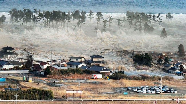
FEMA’s Role in NTHMP
FEMA is a partner agency in the National Tsunami
Hazard Mitigation Program (NTHMP)
Along with the USGS and coastal State and Territory agencies.
We work within the NTHMP Coordinating Committee and
co-chair the Mitigation and Education Subcommittee to
help improve planning, awareness and mitigation.
CC members: HQ: Mike Mahoney; R10: Amanda Siok
MES FEMA co-chair: Tamara Biasco
FEMA also works with SLTT agencies to use their NOAA
tsunami inundation evacuation mapping as the basis for
planning and to improve public awareness.
3
State and Local Planning Actions
Several coastal States have developed required State
Mitigation Plans that include addressing tsunami.
Many communities have recognized their tsunami risk
and are addressing it along with other hazards:
Several coastal counties have FEMA approved multi-hazard
mitigation plans that include tsunami.
Some plans include tsunami mitigation actions to protect
public and critical facilities.
Several communities have completed mitigation activities
using state and local funding.
4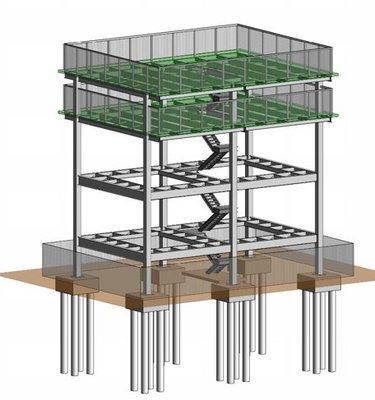
FEMA’s Role in Reducing Risk
Some tsunami-related planning and mitigation projects
can be funded under FEMA all-hazard grant programs.
FEMA’s post-disaster Hazard Mitigation Grant Program
(HMGP) can fund tsunami mitigation pilot projects.
FEMA supported development of a Tsunami Hazard Mitigation
Program in Puerto Rico with Hurricane Georges HMGP funds.
FEMA’s Pre-Disaster Mitigation Program (PDM) has been
replaced by the new Building Resilient Infrastructure and
Communities (BRIC) Program under DRRA Sec. 1234.
BRIC based on 6% of estimated disaster expenses funds.
PDM/BRIC now recognizes tsunami as a fundable hazard.
5
HMGP Tsunami-Related Grants
Washington (Total FEMA Funding Obligated for Tsunami
Mitigation: $6,869,349.50)
Grays Harbor County, City of Ocean Shores Tsunami Vertical
Evacuation Shelter- Federal Share Obligated $3,592,141.50 (PDM)
Grays Harbor County, Stevens Elementary Tsunami Vertical
Evacuation Shelter- Federal Share Obligated-Pending (PDM)
Pacific County, Long Beach Safe Haven Program- Tsunami
Vertical Evacuation Berm- Federal Share Obligated $362,020
(HMGP- DR-4056-0020)
Pacific County, Fire Protection District #1- Preliminary Studies and
Design work for Vertical Evacuation Structure- Federal Share
Obligated $90,000 (HMGP- DR-4249-0008)
Pacific County, Tokeland Vertical Evacuation Tower- Federal
Share Obligated $2,825,188 (PDM)
6HMGP Tsunami-Related Grants
Oregon (Total FEMA Funding Obligated for Tsunami
Mitigation: $2,537,233)
Curry County, Port of Brookings Harbor- Floating Dock
Reinforcement Mitigation for Tsunami- Federal Share Obligated:
$123,500 (HMGP- DR-1764-0002)
Lincoln Co, Newport Tsunami Safe Haven Hill Retrofit, Hardening
and Access Improvements- Federal Share Obligated: $680,478
(HMGP- DR-1764-0002)
Lincoln County, Seal Rock Water District- Water and Sanitary
Sewer System Protective Measures- Federal Share Obligated:
$571,667 (HMGP-DR-4055-0013)
Tillamook County, Bay City Water and Sewer Protective
Measures- Federal Share Obligated $1,161,588 (HMGP)
7HMGP Tsunami-Related Grants
American Samoa Legislative Building: Built to VE zone and
tsunami inundation, using ASCE 24-05 and ASCE 7-10.
California, Samoa Peninsula (Humboldt County) Fire Station
remodeled with HMGP funding to address tsunami vertical
evacuation.
FEMA Region 9 is funding a Cooperating Technical Partner
(CTP) grant with CGS (Rick Wilson) for the Port and Harbor
Tsunami Playbooks and improved tsunami inundation mapping
(USC).
8FEMA Tsunami Exercises
Region 10 led the 2016 Cascadia Rising exercise.
They are currently planning for the June 2022 Cascadia
Rising exercise, using the same scenario.
The exercises assume a Cascadia earthquake event with
a main wave of 30-40 feet in height depending on local
topography (both underwater and along the shore).
The exercises are based a 20- to 30-minute warning time
prior to initial wave arrival.
9National Flood Insurance Program
FEMA identifies flood-prone areas and develops and
distributes Flood Insurance Rate Maps (FIRM) to the over
20,000 participating communities.
FEMA has included tsunami wave heights on FIRM’s
since the 1970’s for areas of the West Coast, Hawaii, and
other Pacific Islands where tsunami is the primary flood
hazard.
FEMA has modernized its FIRM’s through its Risk Map
Program.
Risk Map is intended to include other hazards including tsunami.
10NFIP Tsunami Flood Mapping
NFIP FIRM’s provide a 1% annual chance of flood risk
information for flood insurance rating purposes.
Tsunami wave heights normalized to a 1% annual
chance event may not show the true potential threat
since the maximum tsunami inundation could be much
greater than at a 1% annual probability limitation.
Except for areas like Hawaii where tsunami is the
primary hazard, NFIP has elected to not provide
tsunami inundation zones on recent FIRM’s.
However, our new digital FIRM’s will allow a
community to overlay their own tsunami inundation
maps independent of recurrence frequency if they
wish.
11Flood Loss Reduction Activities
The NFIP Community Rating System (CRS) creates an
incentive for communities to help minimize tsunami risk.
Through CRS, the cost of flood insurance can be reduced
in communities that exceed NFIP minimum requirements.
CRS provides credit when local governments:
Map tsunami run-up areas
Acquire tsunami hazard areas for open space uses.
Zone tsunami hazard areas for open space uses.
Adopt land use planning measures to control development.
Require new structures be built at or above the tsunami elevation.
Prohibit new critical facilities in tsunami hazard areas and adopt
tsunami construction requirements.
Develop local public information and education programs.
Receive the NOAA TsunamiReady designation.
12FEMA’s Tsunami Risk Assessment
Hazus MH, is FEMA’s nationally applicable GIS-based
loss estimation software for earthquakes, wind, and flood.
Hazus seeing widespread use for local/regional planning
for mitigation as well as post-event assessment.
FEMA completed development of the Hazus tsunami
module in 2017 in response to a GAO tsunami report.
The Hazus tsunami module was funded by FIMA NFIP and DHS
Flood Apex Program.
More information on FEMA website:
www.fema.gov/plan/prevent/hazus/index.shtm
13Tsunami Evacuation Issues
Tsunami warning is based on being able to evacuate
at-risk population to high ground.
Current warning systems focus on far-source events;
for near source, the earthquake itself is the warning.
For near-source event, warning time is can be as little
as 15 to 30 minutes.
For many coastal communities, this is not sufficient
time for evacuation to high ground.
In those cases, the best solution is vertical evacuation
to specially designed refuge structures.
14Refuge Design Guide Document
Technical design guidance for special
facilities for vertical evacuation.
Refuge must be able to withstand loads from both
earthquake ground shaking and multiple tsunami
waves and debris and still remain functional.
First edition was a joint FEMA/NOAA project.
Co-funded by FEMA NEHRP and NOAA NTHMP.
Publication distributed by FEMA as FEMA P-646.
Third Edition includes lessons from Tohoku tsunami
and new criteria from ASCE/SEI 7-16 Chapter 6.
Encourages multiple use structures such as parking
garages, community centers, hotels, etc.
Includes design criteria for artificial high ground.
Also includes operational guidance for refuge.
15First US Tsunami Evacuation Refuge
Under its Project Safe Haven, the State of
Washington worked with Grays Harbor County
and the Ocosta School District to get local funding
to build a tsunami vertical evacuation refuge as
part of a new/replacement elementary school.
The roof of the gymnasium serves as the refuge,
which is sized for students and local population.
Total project cost: $ 14,600,000
Local share: $ 11,800,000
State share: $ 2,800,000
Tsunami safe refuge (a local cost): $ 2,000,000
16First US Tsunami Evacuation Refuge
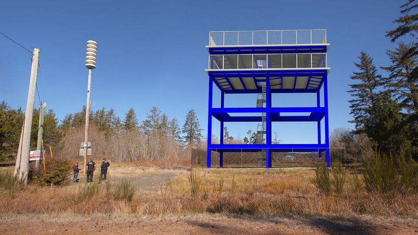
17Second US Vertical Evac. Refuge
Shoalwater Bay Indian Reservation,
located in Tokeland, WA on the
Cascadia coastline.
With the closest high ground 2 miles
away, there would not be enough time
to evacuate.
Sized to fit over 400 evacuees.
Funding:
FEMA funded - $2.2 million,
Shoalwater Tribe - $1 million
FEMA NEHRP provided SME
assistance with the design, which
used FEMA P-646 design criteria.
18Tsunami in the Building Codes
FEMA NEHRP staff, with NOAA support, prepared and
successfully submitted a code change for the 2012 IBC:
This change added a new Appendix M Tsunami. If the Appendix is
adopted by a State or community, it restricts the construction of high
occupancy, high risk, or critical facilities within a community’s tsunami
inundation zone, unless it is a vertical evacuation refuge built
according to FEMA P-646.
Based on lessons learned in the 2011 Tohoku tsunami,
the American Society of Civil Engineers ASCE 7-16
Design Load Standard developed and added a new
Chapter 6 – Tsunami Loads and Effects.
This chapter added new tsunami hazard maps and design load and
construction criteria.
19Chapter 6: Tsunami Loads and Effects ASCE/SEI 7 is the consensus design standard used to determine design loads for US building design for natural hazards. ASCE/SEI 7 is adopted by reference by the International Building Code, which in turn is adopted by most US jurisdictions. The 2016 edition of ASCE/SEI 7 includes a new Chapter 6 on Tsunami Loads and Effects. ASCE/SEI 7-16 adopted by reference into the 2018 IBC. Design criteria based on 2500-year Maximum Considered Tsunami.
Chapter 6: Tsunami Loads and Effects
Only applies to the five US Western States – Washington,
Oregon, California, Alaska and Hawaii
Only applies to Risk Category IV (Essential Facilities) and III
(High Occupancy Buildings).
Will only apply to Risk Category II (General Building Stock) if
adopted by the local jurisdiction, and then only for buildings
over a particular height.
Will not apply to all other Risk Category II, including light
framed residential or commercial buildings.
Based on the assumption that communities have access to the
NOAA tsunami warning system and an effective evacuation plan.Conclusion
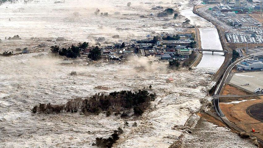
Tsunamis are very rare events but ones with very high
consequences, as shown in the Indian Ocean and Japan.
As rare events, they tend to fall below the attention level
of the American public. However, we need to encourage
actions that will improve their protection.
We need to be able to provide the tools that states and
local communities need to be able to address their risk
from this rare but potentially catastrophic hazard.
Because of the large numbers of people that are at risk,
FEMA continues to work to improve preparedness and
awareness, and reduce the risk from future tsunamis.
25You can also read