Candidates for Officers for the American Association for Geodetic Surveying, 2023
←
→
Page content transcription
If your browser does not render page correctly, please read the page content below
Candidates for Officers for the American Association for Geodetic
Surveying, 2023
November 8, 2022

President Elect (vote for one)
                                   Dr. Eugene Levin, (ASPRS Certified Photogrammetrist) is an expert in
                                   geospatial science and technology with 30+ years of academic and
                                   industry experience in geodesy, photogrammetry, GIS, WebGIS,
                                   mapping, remote sensing, cartography, 3D visualization, human factors,
                                   robotics, Lidar, If-SAR, UAV, and aerial and satellite product
                                   development. Specifically, he has created new eye tracking-based
                                   approach to cognitive GIS and geospatial image processing; developed
                                   4D-GIS system for manned/unmanned robotic platforms navigation,
                                   guidance, control, and prediction; initiated, designed, and tested small
                                   UAV platforms including one produced on 3D printer; and developed
                                   mobile mapping platform integrating GPS, lidar, and imaging sensors.
                                   Dr. Levin joined School of Applied Computational Sciences as a
                                   faculty member in 2021. Before that he served as an Associate
                                   Professor and Program Chair of Surveying Engineering in School of
                                   Technology at Michigan Technological University. Dr. Levin served
                                   also as a founding Director of the integrated Geospatial Technology
graduate program at Michigan Tech. Dr. Levin has demonstrated sustainable research collaborations with
scientists from Germany, Israel, Italy, Poland, Russia, and Kazakhstan. He served as Principal
Investigator and Program Manager in multiple awarded grant programs for the NASA, NGA, U.S. Air
Force, Navy, Army, and HSARPA.

                                    Scott P. Martin has been a licensed Professional Land Surveyor in
                                    California for 36 years. He graduated from College of the Redwoods
                                    in Eureka California in 1982. He worked in the private sector for 15
                                    years prior to joining state service.

                                    He served as the Geodetic Branch Chief for the California
                                    Department of Water Resources from 2003-2012, where he was the
                                    project surveyor for several Height Modernization projects. In 2008,
                                    he served as the internal technical expert for the Sacramento Valley
                                    Height Modernization Project, which included over 320 stations and
                                    covered roughly 5,000 square miles.

                                    He joined the California Department of Transportation (Caltrans) as
                                    the Chief of GPS Surveys and Geodetic Control at headquarters in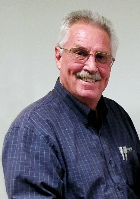
2012. He was promoted to the Deputy Division Chief of Right-of-Way and Land Surveys in October
2020.

Scott has been a member of the Coordinating Council of the California Spatial Reference Center (CSRC)
since 2001 and has served as an elected officer of the CSRC Executive Committee. During this time, he
has been instrumental to the production of the CSRC 2017.50 epoch update of NAD83(2011) and
research involving the development of a 3-D dynamic datum modeling utility to model positions over
time in the geophysically challenging environment of California.

In 2016, Scott was appointed as the first California Geodetic Coordinator by the CSRC. In this role, he
works closely with the NGS Pacific Southwest Regional Geodetic Advisor to support the California
Surveying and Geospatial communities and provide guidance on issues such as control monument
preservation and perpetuation.

Scott presented at the 2018 UESI/Cal Poly Pomona Surveying and Geomatics Conference and the 2019
NGS Geospatial Summit. He also provided peer review for the Oregon DOT/Oregon State University
research project SPR 304-821.

Scott was elected to the AAGS Board of Directors in December 2021 and has been active in several
initiatives, including establishing an AAGS Speaker Series and providing support for the emerging “Ask
a Geodesist” feature on the AAGS website. He is seeking an opportunity to serve in the President Elect
leadership role to help position AAGS to serve a critical role in assisting the geodetic surveying
community with preparing for, and transitioning to, the new National Spatial Reference System scheduled
for release by NGS in 2025.

Director (vote for one)
                                   John J. Doody PS/PE is a professional surveyor and civil engineer
                                   licensed to practice in Connecticut (PELS 15560). Mr. Doody
                                   graduated with a B.S.C.E. (1983) and an M.S. Env. Eng (1993) from
                                   the University of New Haven, Connecticut. He worked as a survey
                                   supervisor for the CT Dept. of Transportation for 35 years in
                                   Southwestern Connecticut, surveying and mapping highways and
                                   railroads. He was an early adopter of GPS technology starting in 1993
                                   for GPS static control uses. John has taught as an adjunct faculty
                                   member of the Civil Engineering program at Central Connecticut State
                                   University since 1989, teaching basic and advanced surveying,
                                   Introduction to GPS Mapping, and presently teaching
                                   "AutoCAD/Civil 3D". He developed and taught a 15-week on-line
                                   boundary law course at Charter Oak State College for 5 years.

Mr. Doody has been an active member of the Connecticut Association of Land Surveyors (CALS) for
over 25 years, working on the professional development and scholarship committees. He was awarded the
CALS Surveyor of the Year in 1999 and 2001, and the CALS Distinguished Surveyor Award in
2013. John is a member of the American Association of Geodetic Surveyors (AAGS) and a fellow in the
National Society of Professional Surveyors. On December 31, 2014, John became the first (and only!)
recipient of the Charter Oak State College Certificate in Land Surveying. In 2015, Mr. Doody was
awarded the Earle J. Fennell award by NSPS, for excellence in teaching in 2015.
John is the co-author of Resources for Tidal and Navigable Waters in Connecticut (2012), and author of
Water Boundaries for Land Surveyors (2020), published by the Connecticut Association of Land
Surveyors in 2021. He has presented numerous workshops for CALS over the last 20 years.
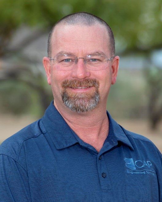
Brian S. Fisher, PLS is a registered Professional Land Surveyor
in Arizona and is a graduate of Arizona’s Phoenix College with an
AAS in Land Surveying. His surveying and construction career
began in 1989 with the Naval Mobile Construction Battalion
“Seabees”. His current position is with the Central Arizona Water
Conservation District as a geodetic surveyor. During his career, he
has been the president of a private survey/engineering firm,
adjunct faculty at Arizona’s Phoenix College, and has held
numerous project management positions in both the private and
public sectors. He is an active member in several associations
including, Arizona Professional Land Surveyors (APLS), Arizona
Geographic Information Council (AGIC), National Society of
Professional Surveyor (NSPS), and the American Association for
Geodetic Surveying (AAGS). He is the National Geodetic Survey
State Geodetic Coordinator for Arizona since 2017.
Mr. Fisher's interest in running for the AAGS director’s position is to accomplish three key goals. First,
continue the efforts of membership outreach and expansion for AAGS. Second, create a collaborative
group with the NSPS Certified Survey Technician (CST) program to improve their education and testing
program related to geodetic surveying. Third, offer all AAGS members a meeting place to discuss and
share NSRS modernization ideas and stories. By sharing our successes we can improve the voluntary
collaborative relationship between the National Geodetic Survey and state-level agencies so that we as a
nation may have the maximum benefit from federal and local participation.
You can also read