ALL-ROUNDER IN THE STARTING BLOCKS - ELIB-DLR
←
→
Page content transcription
If your browser does not render page correctly, please read the page content below
German Aerospace Center (DLR) · No. 165 · August 2020

ALL-ROUNDER IN THE
STARTING BLOCKS
HYDROGEN AS AN ENERGY CARRIER

            More topics:
              ANNIVERSARY IN THE ARCTIC CIRCLE
              Ten years of satellite reception in Inuvik

              A UNIQUE CLOUD COCKTAIL
              Research aircraft study the clouds, weather and climate
EDITORIAL
DLR at a glance

DLR is the Federal Republic of Germany’s research centre for aeronautics and space. We conduct         TIMES OF CHANGE
research and development activities in the fields of aeronautics, space, energy, transport, security
and digitalisation. The DLR Space Administration plans and implements the national space               This edition of DLRmagazine is the second to be produced           Dear reader,
programme on behalf of the federal government. Two DLR project management agencies                     under the adverse conditions of the Coronavirus pandemic.
oversee funding programmes and support knowledge transfer.                                             While the finalisation of the spring issue – number 164 – coin-    Some opportunities go by unused, and technologies that
                                                                                                       cided with the lockdown, this issue has been done almost           seem to have great potential disappear without a trace.
Climate, mobility and technology are changing globally. DLR uses the expertise of its 55 research      exclusively from our home offices, under the conditions            Fortunately, others come to fruition after a long wait. For
institutes and facilities to develop solutions to these challenges. Our 9000 employees share a         imposed by DLR’s switch to minimum operational status and          some time now, the most common element in the Universe
mission – to explore Earth and space and develop technologies for a sustainable future. In doing       the subsequent slow relaxation of the restrictions. But we         – hydrogen – has been the focus of particular attention from
so, DLR contributes to strengthening Germany’s position as a prime location for research and           were also able to experience that a standstill does not neces-     scientific researchers, industry, policymakers and society . It is
industry.                                                                                              sarily mean a complete stall. During the production of this        flexible, can be stored relatively easily and burns cleanly.
                                                                                                       issue, we received impressive contributions about the ways in      Industry has been researching the use of hydrogen for a long
                                                                                                       which research can be supported in exceptional situations,         time, and the principle of electrolysis has been known for
                                                                                                       how it can be maintained with commitment and clever ideas,         over 200 years. Newer processes are expected to achieve
                                                                                                       and how it is able to function under suddenly changed              higher efficiencies. Can hydrogen establish itself as the
Imprint                                                                                                circumstances. For example, the DLR sites in Stuttgart,            energy source that will help to mitigate climate change and
                                                                                                       Bremen, Oberpfaffenhofen and Braunschweig converted their          finally find its calling? In any case, DLR is conducting research
DLRmagazine – the magazine of the German Aerospace Center                                              laboratories to manufacture face shields and thereby helped        into this multi-talented element in many areas.
                                                                                                       overcome supply bottlenecks. Research flights to study the
Publisher: DLR German Aerospace Center (Deutsches Zentrum für Luft- und Raumfahrt)                     atmosphere as well as plasma crystal experiments on the            Other ‘all-rounders’ are also showcased in this issue. There
                                                                                                       International Space Station ISS were planned and coordinated       are, for example, space technologies that are used for huma-
Editorial staff: Nils Birschmann (Legally responsible for editorial content), Cordula Tegen,           from the scientists’ home offices. Transport researchers laun-     nitarian assistance and flexible ‘bandage’ energy storage
Julia Heil, Elke Heinemann (Editorial management), Karin Ranero Celius (English-language editor,       ched surveys on how a pandemic could change our mobility,          systems developed by the team around materials researcher
EJR-Quartz BV).                                                                                        and much more.                                                     Bilge Saruhan-Brings. You can find out why they are called
                                                                                                                                                                          ‘bandages’ in an interview with her. Or accompany Tobias
                                                                                                       Instead of causing paralysis, the crisis has acted as a stimu-     Bellmann to the Innovation Laboratory in Oberpfaffenhofen.
DLR Department of Public Affairs and Communications                                                    lant, releasing new potential and ideas. Once again, it shows      Here, he and his team have built up an extraordinary world of
Linder Höhe, D 51147 Cologne                                                                           how fruitful it can be when everyone pulls together to make        mechatronic simulations from almost all DLR departments.
Phone +49 2203 601-2116                                                                                projects possible. Public authorities, scientific and industrial
E-mail info-DLR@dlr.de                                                                                 partners in research, and even printers, agencies and distri-      Other topics covered in this issue include the new Multifocus
Web DLR.de/en                                                                                          butors are among those who report this.                            Tower in Jülich, the tenth anniversary of the DLR ground
Twitter @DLR_en                                                                                                                                                           station in Inuvik and the spin-off ajuma, which has developed
                                                                                                       Time has obviously not stood still either and some changes         a device that reliably warns against sunburn.
Printing: AZ Druck und Datentechnik GmbH, 87437 Kempten                                                that seemed to be a long way off last year ‘suddenly’
Design: bplusd agenturgruppe GmbH, Vitalisstraße 67, 50827 Köln, www.bplusd.de                         happened. This issue is the first with a new editor-in-chief and   We hope that you enjoy reading this issue,
                                                                                                       the last for retiring editor-in-chief Cordula Tegen, who has
ISSN 2190-0108                                                                                         been in charge of this publication for the last 13 years. With     Your DLRmagazine editorial team
                                                                                                       professionalism, openness and passion, she made DLRmaga-
Online:                                                                                                zine what it is today, and every single issue something very
DLR.de/dlr-magazine                                                                                    special. Now, she is starting her well-deserved retirement. We
                                                                                                       wish her all the best and say:
Order online:
DLR.de/magazine-sub                                                                                    Thank you!

Content reproduction allowed only with the prior permission of the publisher and must include
a reference to the source. Some English-language material has been translated from the German
original. The respective author(s) are responsible for technical accuracy of the articles.

All images are property of DLR and published under a CC-BY 3.0 unported licence unless
otherwise stated.

                                                             Printed on recycled,
                                                             chlorine-free bleached
                                                             paper.

              German Aerospace Center

                                                                                                                                                                                                             E DI T O R I AL DLRmaGazin 165 3
DLRmagazine 165
NEW INSTITUTES FOR MOBILITY AND ENERGY6
IN BRIEF7
DIGITAL URBAN PLANNING10
The Digital Atlas – a one-of-a-kind database
ALL-ROUNDER IN THE STARTING BLOCKS 22 POWERED BANDAGES 30
A UNIQUE CLOUD COCKTAIL14
Flight campaign studies the atmosphere over Barbados
TAKING TO THE SKIES IN TIMES OF A PANDEMIC20
Research flights during the lockdown
ALL-ROUNDER IN THE STARTING BLOCKS22
Hydrogen as an energy carrier
POWERFUL DUO28
Solar research at DLR Jülich grows
POWERED BANDAGES30
New and flexible energy storage
ANNIVERSARY IN THE ARCTIC CIRCLE32
A decade of satellite reception in Inuvik
SMART WITH THE SUN 44 HIGH-TECH HELPING HAND 36
HIGH-TECH HELPING HAND36
Space technologies for humanitarian purposes
IN BRIEF41
ELECTROMOBILITY IN SWAHILI 50
PERSPECTIVE42
Mud volcanoes on Mars
SMART WITH THE SUN44
The UV-Bodyguard protects against sunburn
IN THE LABORATORY OF A THOUSAND POSSIBILITIES46
DLR‘s Systems and Control Innovation Lab
ELECTROMOBILITY IN SWAHILI50
Motorcycle taxis in Tanzania
ANNIVERSARY IN THE ARCTIC CIRCLE 32 FULL SPEED AHEAD FOR THE MOBILITY TRANSITION54
Interview about autonomous driving
DIGITAL URBAN PLANNING 10 A STUNNING GEM56
At the Berlin Museum of Energy
A UNIQUE CLOUD COCKTAIL 14
REVIEWS58
4 DLRmaGazine 165 C O N T E NT S C O NT E NT S DLRmaGazine 165 5
NEW INSTITUTES FOR MOBILITY AND ENERGY
O n 23 June 2020, the DLR Senate decided to establish two new institutes. The Institute of Systems Engineering for
Future Mobility will be located in Oldenburg. The Institute of Maritime Energy Systems in Geesthacht will focus
IN BRIEF
on reducing emissions from shipping.
NASA’S MARS 2020 MISSION IS ON
© NASA/JPL-Caltech
SAFE AND AUTONOMOUS ENVIRONMENT-FRIENDLY ENERGY
ON THE ROAD SYSTEMS FOR SHIPPING ITS WAY TO THE RED PLANET
The technologies used in the automated and autonomous vehicles of Ships carry around 80 percent of freight. They are responsible for On 30 July 2020, the Perseverance rover and Ingenuity helicopter
the future will have to be highly reliable. To this end, the new DLR approximately three percent of global carbon dioxide emissions. Cruise departed for Mars. They will land near the rim of Jezero Crater in
Institute of Systems Engineering for Future Mobility, which emerged ships also produce emissions that lead to air pollution. The new DLR February 2021. Perseverance carries seven scientific instruments with
out of the Oldenburg-based computer science institute OFFIS e.V., will Institute of Maritime Energy Systems is the first research centre in the which it will analyse the geology of the landing site, search for signs
develop methods and tools for industrial processes. In collaboration world to systematically examine the entire energy conversion chain in of past microbial life in rocks and sediments, and find the most promi-
with the DLR Institute of Transportation Systems, these tools will then shipping. Researchers at the Institute in Geesthacht will develop and sing samples for subsequent analysis on Earth. Ingenuity is a
be used in the Test Field Lower Saxony to test new system functions. test solutions for decarbonising shipping, and work with industry to technology demonstrator; it will be the first aircraft to attempt cont-
In addition, the new Institute already has a world-renowned test field bring them into use. Their development work will focus on fuel cell rolled flight on another planet. Digital terrain models derived from
for automated maritime transport systems. systems and alternative fuels. Specialists will look at the entire energy images acquired by the DLR High Resolution Stereo Camera carried
system on board, including electricity supply, heating and cooling. on ESA’s Mars Express spacecraft were supplied to the Mars 2020
mission team and made an important contribution to the landing site
selection process. The camera carried by Perseverance will acquire 3D
colour images. DLR is represented on the Mars 2020 mission science
team and will be involved in evaluating and interpreting the images. Mars rover Perseverance and helicopter Ingenuity
COPERNICUS EARTH OBSERVATION
© ESA/Pierre Carril
PROGRAMME EXPANDS
On 1 July 2020, following a European competition, the European Space Agency
Institute of Systems Institute of Maritime (ESA) awarded contracts for the development and construction of six further
Engineering for Energy Systems Copernicus Sentinel satellites. These will help find answers to the global challenges
Future Mobility Geesthacht posed by climate change, population growth and environmental problems. Sentinel
Oldenburg satellites are at the heart of Copernicus, Europe’s largest Earth observation
Founding director: programme. They are already reliably and continuously providing large amounts
Founding director: Alexander Dyck of data on the state of the climate, vegetation and oceans. Now, six more ‘Earth
Stade
Axel Hahn Hamburg Guardians’ are being added. The contracts are worth a total of more than 2.5
Planned staff:
Bremerhaven 250 billion euro, of which approximately 800 million euro will go to space companies
Planned staff: Bremen Geesthacht Neustrelitz in Germany. Some of these new missions will measure atmospheric gas concent-
80 Oldenburg Trauen
Website: rations, land surface temperatures, ice mass thicknesses, and ocean ice cover and
Website: Hanover Berlin DLR.de/ms/en surface temperature. Others will classify land cover and determine soil moisture
DLR.de/se/en Sentinel-3 satellite in space content, as well as performing imaging spectroscopy of the land surface.
Braunschweig Cottbus
Cochstedt
Jülich Cologne Göttingen Zittau
Sankt Dresden
Merzbrück Augustin
Aachen Bonn Jena
Rheinbach
TEN YEARS OF 3D MAPPING
Lampoldshausen
FROM SPACE
Stuttgart A new era in radar remote sensing began 10 years ago with the launch
of the German radar satellite TanDEM-X. Since then, it has been orbi-
Ulm Augsburg ting Earth in close formation with its ‘twin’, TerraSAR-X, which is three
Oberpfaffenhofen New location years older. The distance between the satellites varies between several
Weilheim Existing location kilometres and sometimes only 120 metres. This enables the radars to
New addition to existing location obtain a 3D view of Earth in a single pass. This is referred to as a bistatic
interferometer in space, which allows the terrain structure to be
recorded in 3D in just one pass. The mission continues to be globally
unique. The primary objective – the creation of a highly accurate global
The DLR Senate also gave the green light to the Institute of Future Fuels (Jülich), the Institute of Low-
Emission Aero Engines (Cottbus) and the DLR research programme ‘Electric Flight’. Two new facilities –
elevation model of Earth’s entire landmass – was achieved by mid-2016.
Small Aircraft Technologies (Aachen, Merzbrück) and the Unmanned Aircraft Systems Competence In future, further surveys are planned that will concentrate on monito-
Center (Cochstedt) – will be established for this purpose. The four institutes and facilities will be presented ring ice sheets and permafrost areas, large-scale forest evaluations, The TanDEM-X Digital Elev ation Model (DEM) covers Earth’s entire land surface –
in more detail in the next issue of the DLRmagazine. particularly for tracking deforestation, and the observation of 2000 a total of more than 148 million square kilometres. The absolute height accuracy
cities worldwide for continuous mapping of urban settlement areas. is one metre.
6 DLRmaGazine 165 N E W D LR INS T IT UT E S AND FAC ILIT IE S I N B R I E F DLRmaGazine 165 7
ANALYSING HELICOPTER NOISE RADAR TECHNOLOGY REVEALS DLR ACROSS GERMANY
DLR has investigated the acoustic properties of the Rapid And Cost- WEAK POINTS IN BUILDINGS BRAUNSCHWEIG: A flexible skin between
Effective Rotorcraft (RACER), a demonstrator that flies faster, farther
the wing and flap system of an aircraft has
and more efficiently than previous helicopters. Researchers at DLR
been designed to reduce aircraft noise by
Braunschweig and the French Aerospace Lab (ONERA) carried out a
providing improved aerodynamic properties.
complete acoustic analysis in various flight modes, investigating noise
The DLR Institute of Composite Structures
from the rotor and propellers. Computational data can now be used
and Adaptive Systems is working with Invent
to demonstrate that RACER will fly at over 400 kilometres per hour,
GmbH and the Technical University of Munich
making it 100 to 200 kilometres per hour faster than any conventional
to develop this transition skin, made of rubber
helicopter. In addition, it is very quiet despite having two propellers in
and glass fibre, as part of the FlexMat project.
addition to a rotor. Quiet flight behaviour is possible because RACER
can be flown like an aeroplane. Low noise is an important prerequisite
JENA: A high-performance data analysis cluster
for the future demonstrator, as it is specifically designed for rescue
was inaugurated at the DLR Institute of Data
missions, the provision of emergency medical assistance, and public
Science in early July. It is intended to support scien-
and private delivery and transport flights. In addition to its work on
tific computing needs, especially DLR research in
acoustics, DLR is also playing a crucial role in the aerodynamic design
the fields of machine learning, visual analytics,
of the wings and the tailplane. Computational simulation of the noise contour emanating from the main GTOM antennas examine the wall of a house
climate informatics and citizen science.
rotor and propellers during RACER’s flight, and a representation of the
‘noise footprint’. If doctors need to take a detailed look inside their patients, magnetic reso-
LAMPOLDSHAUSEN: A 3D-printed combustion
nance imaging is often the method of choice. For buildings as well, looking
chamber has been successfully tested on the P8 test
at the inner structure or ‘skeleton’ is often necessary to assess their struc-
stand. The chamber will be used in the upper stage
tural condition or energy efficiency.
engine of the new European launcher Ariane 6. Such
cutting-edge manufacturing processes increase the
A research team from the DLR Microwaves and Radar Institute has devised
performance of space propulsion systems while
a way of using radar technology to analyse the external and internal walls,
simultaneously reducing production costs.
ceilings, floors and roofs of buildings in a contact-less, non-destructive
HELPING AUTOMATED VEHICLES manner. Radar waves penetrate non-metallic matter and are partially
NEUSTRELITZ: DLR researchers from the German
reflected at layer boundaries. The properties of the reflections provide
COMMUNICATE information about the layers and thickness of the materials used.
Remote Sensing Data Center have tested technology
at a regional testing site in Mecklenburg-Vorpommern
Researchers scan walls from the side or use drones to acquire data that they
that will help farmers estimate crop yields and deter-
Whether with turn signals, hazard warning lights or flashing blue then use to create 2D and 3D radar images of the wall structure. The GTOM
mine soil moisture. Scientists use geodata from sensors
lights, vehicles often use light signals to communicate with other project was successfully completed in early August.
on satellites or drones for this purpose.
road users. As part of the EU project interACT, DLR researchers have
worked with European industry to develop new solutions that enable
OBERPFAFFENHOFEN: In the eFence project, scientists
automated and networked vehicles to communicate safely and reliably
from the DLR Institute of Communications and Navi-
by means of light signals. Light is a good way of transmitting simple
gation conducted research into communications and
messages. Language and symbols, in contrast, can easily lead to
misunderstandings. The project partners have developed a special LED THE BEPICOLOMBO SPACECRAFT positioning technologies that can be used to detect
road users who are not equipped with communica-
light strip with this in mind. It runs beneath the windows and around
the whole car, flashing several times if the automated vehicle wants to VISITS VENUS tions devices.
let a pedestrian cross the street. A small lamp is attached to the front
STUTTGART: Europe’s largest research observatory for
Image: ESA
of the windscreen at rear-view mirror level. It can only be seen by a
DLR and its partners developed a special LED light strip, which runs beneath the detection of near-Earth satellites and space debris
the windows and flashes several times if the automated vehicle wishes to single person, who therefore knows that the flash from the LED strip
is currently being built on the Innovation Campus in
signal to a pedestrian to cross the street. is meant for them.
Empfingen. The inauguration of this DLR facility is
planned for spring 2021. It will use laser technology
to determine the trajectory and characteristics of
objects in near-Earth orbits quickly, precisely, and
reliably.
REDUCING AIRCRAFT NOISE
Part of the noise from aircraft is generated by the wing. BepiColombo will travel a total of approximately nine billion kilometres, including a
Where high-lift devices and control surfaces meet the wing, total of nine flybys of Earth, Venus and Mercury, before reaching its destination.
there is an abrupt transition between the airflow over
these aerofoils and that flowing over the fixed part of the BepiColombo will fly past Venus on 16 October 2020. But this is not the
wing; these transitions cause some of the noise. Could a final destination for Europe’s largest ever planetary science mission. It is
flexible surface between the wing and the moving surfaces on its way to Mercury, the planet closest to the Sun. BepiColombo will
reduce this? DLR researchers have been working with part- perform two flyby manoeuvres around Venus, and use its gravitational
ners in academia and industry to address this question. field to decelerate before setting a course for Mercury on 11 August 2021. DLR.DE: FOLLOW THE LATEST NEWS
An experimental configuration based on a one-metre span The amount of propellant that can be carried by a spacecraft is limited by BY VISITING THE DLR PORTAL
of the outboard wing section of an Airbus A320 was inves- the capabilities of the available launchers. Due to the Sun’s enormous All articles can be viewed online in the
tigated. The slat on the leading edge was replaced with a gravitational attraction, this means that visiting other planets in the Solar news archive with images or videos.
variable-shape leading edge, referred to as a droop flap. System can only be achieved through this kind of complex trajectory. Be-
The transition skin consists of a mix of materials – synthetic piColombo is scheduled to enter orbit around Mercury on 5 December
rubber and glass-fibre reinforced composites. The rubber 2025. Once there, the DLR-developed MERTIS spectrometer will examine DLR.de/News
forms the basis for the skin, into which glass-fibre plates the composition and mineralogy of Mercury’s surface and interior. In April
are inserted at varying intervals. Testing revealed that the The leading-edge slat on the wing has been replaced by a droop flap – a variable-shape 2020, MERTIS acquired images of the Moon from space. Scientists hope
skin is very hard-wearing and highly deformable. leading edge developed at DLR in 2007. The transition skin was installed as an addition. that it will be able to provide similarly revealing images of Venus.
8 DLRmaGazine 165 I N B R I E F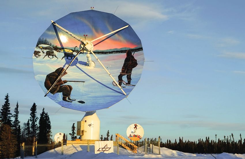
DIGITAL URBAN PLANNING
The DLR research junction in
Braunschweig. Various sensor systems
record the traffic situation to better
understand the behaviour of road users.
The project’s primary focus is on geodata – digital information that can The Remote Sensing Technology Institute and the Microwaves and Radar
be assigned to a spatial location on Earth’s surface. This includes data Institute in Oberpfaffenhofen are now investigating new methods to
from moving traffic on the ground, on water and in the air. The acquire the necessary data using satellites and aircraft equipped with
researchers are accessing information from satellites, aircraft and imaging radar sensors and high-resolution camera systems. These data
ground-based sensor technologies as they collect their data. The cross- can be recorded in a much shorter timeframe and make it possible to
sectoral project benefits from the different fields of expertise of the determine the position of objects to within 10 centimetres anywhere in
DLR institutes involved, with researchers working in the fields of aero- the world. This requires highly accurate reference points, which are
nautics, space, energy transport and security, as well as in the fields obtained from satellite data.
of data collection and socio-economic analysis.
Layer by layer
Each map consists of individual layers that highlight specific topics. These
might be types of roads, the distribution of vegetation and trees, or the
location of solar power systems. This enables urban planners to assess the
necessary roads and transport connections – not only within a city, but
also in the surrounding area. In addition, comparisons can be made with
other cities across the globe. Metadata describe the maps in greater detail,
allowing the user to quickly assess the topic in question or the spatial
accuracy and resolution of the map. They are also able to perform a search
using keywords.
Close-up of a 3D model of the city Braunschweig in 3D
of Braunschweig showing all
transport-related details In an initial subproject, the DLR Institute of Transportation Systems gener-
ated a 3D model of Braunschweig largely automatically, using sources
such as cadastral information, aerial images and survey data. Wherever Neural networks can make categories such as buildings, roads and vegetation
possible, thematic maps derived from raw data were processed and veri- visible in an aerial image, and even extract lane markings.
fied in this way. This process is gradually being developed into an
all-encompassing geodatabase for all modes of transport. To ensure that
A unique database is being created in DLR’s cross-sectoral the ‘virtual’ database represents reality as closely as possible, the
researchers are studying various use cases with different modes of trans- WHAT IS A GEODATABASE?
‘Digital Atlas’ project port. They then compare the data from these use cases and use them as
the basis for the Digital Atlas. Spatial data, otherwise known as geodata, are acquired and
managed in a geodatabase. They are structured using a spatial
By Rüdiger Ebendt Satellites and aircraft capture the condition of roads data model based on a coordinate system. Such models
include the following:
The condition of the roads plays an important role in traffic safety
and fuel efficiency. Cracks and potholes cause damage that continues • g
eometric data such as the location and extent of building
to spread if it is not detected early enough. This is also an important and landscape objects,
issue for automated or autonomous vehicles. In order to adjust their
speed and driving style appropriately, the sensors of such vehicles • topological data to describe the spatial relationships
C ities are growing, and with them, so are the demands on urban planning. For transport planning in
particular, the needs of many groups – citizens, city authorities, vehicle manufacturers and transport
companies – must all be taken into account. They all want congested traffic areas to be as safe to use and as
must not only be able to recognise infrastructure and obstacles, but
also lane markings and the condition of the road surface. Until now,
creating road maps has been a laborious task, requiring specialised
between the objects,
• thematic or descriptive data, such as the colour of a
free of disruption as possible. Achieving this requires access to reliable information and data. Such data vehicles to drive along all of the roads. This is time-consuming and house, and
should, wherever possible, come from a single source, rather than numerous ones that are based on different expensive. Positional data in cities and narrow streets are also often
assumptions. This is the only way of ensuring that they can be combined and evaluated in a meaningful only accurate to within a few metres due to the ‘shadowing’ effect • n
ominal data – that is, purely descriptive information such
way. In DLR’s cross-sectoral ‘Digital Atlas’ project, researchers from 10 DLR institutes are developing a of densely packed buildings and structures that cause signal block- as the name or location of an object.
database that will enable better design and organisation of urban planning and energy supply. ages and reflections.
DI GI TAL I S AT I O N DLRmaGazine 165 1 1
By combining overlapping aerial images, researchers create a surface infrastructure and services. However, there is often a lack of precise
model and what is referred to as an orthomosaic – a distortion-free, knowledge about the size and spatial distribution of the population.
true-to-scale representation of Earth’s surface. All roads, lane mark- With this in mind, the DLR Institute of Transport Research is devel-
ings, masts, buildings and vegetation are depicted and integrated oping new methods for determining traffic volumes. These new
into the Digital Atlas. Intelligent algorithms identify objects using methods have the advantages that they require less data, and that
machine learning and categorise them. The researchers determine the data that they do use can be collected worldwide using remote
the condition of the roads using black-and-white radar images. Small sensing. This makes it possible to derive traffic volume models for
differences in brightness within the images provide information any region in the world.
about the roughness and material properties. By comparing these
images with ground-based reference data, it is possible to determine The main sources of information for these types of models include
the roughness value in the millimetre range. data relating to land use, settlement patterns, as well as density and The building of the Institute of
type of buildings. DLR’s German Remote Sensing Data Center obtains Networked Energy Systems and the
such information from high-resolution satellite and aerial image data. Wechloy campus of the University of
Oldenburg. Left: optical image, right:
These can be used to determine the distribution of the population
hyperspectral image. Solar power
within an area. The researchers are also using freely available data systems are detected in the hyperspectral
from the OpenStreetMap project, particularly those relating to road images using artificial intelligence
networks. This enables them to calculate how easily destinations techniques. This helps to predict the
within an area can be reached from a particular location using various amount of solar power more accurately.
means of transport. The researchers are drawing upon these and
other data to develop a model of the overall traffic volume. Such
models can then be used to investigate the impact of new mobility
options, such as dial-a-bus services and other types of on-demand Predicting solar power production in cities
transport, on mobility behaviour.
When is power from private solar power systems fed into the electricity
Dynamic maps for safe and secure ports grid, and how much do these contribute? Power grid operators urgently
need an answer to these questions in order to be able to integrate
Keeping track of people and goods in ports is particularly difficult. renewables into the grid. This requires information about solar PV
The DLR Institute of Optical Sensor Systems and the DLR Institute for systems on rooftops and in open spaces, preferably collected in an auto-
the Protection of Maritime Infrastructures are looking into the crea- mated way. The DLR Institute of Networked Energy Systems is conducting
tion of dynamic two- and three-dimensional maps in real time. research in this field together with the German Remote Sensing Data
Special sensor systems designed and developed by the institutes are Center. In order to identify solar power systems, researchers are analysing
used for this purpose. Real-time implementation is also an essential optical and hyperspectral high-spatial-resolution data acquired during
The Modular Aerial Camera System (MACS) acquired images of the harbour part of their work. The maps help authorities and emergency flights over urban areas in Germany. Hyperspectral sensors perceive a
area in Bremerhaven for the creation of high-resolution maps personnel with security-related tasks, and port authorities and continuous spectrum of electromagnetic waves, so they can identify
terminal operators to quickly identify and assess critical situations, objects more accurately on the basis of their spectral properties. The
such as the danger posed by suspended loads or unauthorised access optical and hyperspectral images are used to create digital elevation
Intelligent models show traffic volume to the site. The first step is the image data acquisition by an airborne models and determine building outlines.
flight campaign and the production of high-resolution maps. Artifi-
For the automated detection of solar power systems, the software must be able
The Digital Atlas is also intended to model future developments and cial intelligence algorithms then identify ships, road users and other FlexiGIS is an open-source model for the simulation of urban energy to distinguish between different elements in order to avoid misclassifications.
the consequences of implementing changes. Traffic model simula- objects, such as freight containers, from images acquired on the infrastructure developed at the DLR Institute of Networked Energy Roofs like this are used for test purposes; here, both solar-thermal and
tions serve this purpose and show the resulting impact on mobility. ground. Software also determines their exact position and integrates Systems. FlexiGIS can be used to model power generation in urban photovoltaic elements can be seen, but also a roof window, which must not
These may include the introduction of new means of transport, the the objects into a situational picture. This results in a combined solar power systems – based on examples and use cases of the city of be incorrectly labelled as a solar power system.
expansion of infrastructure, or restrictions for certain road users. Such system comprised of aerial and ground images and the associated Oldenburg. This data help scientists to forecast solar irradiance with
models require various types of data – information about the popula- evaluation algorithms. These dynamic maps are also ideal for making spatially and temporally high resolution by combining them with data
tion demographics, possible travel destinations, and transport autonomous traffic in ports safer. from meteorological satellites. This assists network operators in grid
control and thus supports the stability of the power grid. THE DLR DIGITAL ATLAS CROSS-SECTORAL
Clear catalogue for different user groups PROJECT
These four different use cases illustrate the complexity of this cross-sectoral Participating institutes:
project. In further applications, the aim is to expand the geodatabase and
Institute of Transportation Systems (Coordination)
methods to as many modes of transport as possible, for example rail
transport, and to include new types of mobility. However, the results Institute of Vehicle Concepts
obtained can only be used properly and to their full extent if the Digital German Remote Sensing Data Center
Atlas is structured in a clear and comprehensible way. For this reason, Microwaves and Radar Institute
future research will focus on the further development of a user-friendly
Remote Sensing Technology Institute
geodata catalogue. All of the datasets will be stored there and clearly
Three-dimensional, real-time labelled. At the end the project, the Digital Atlas will be used in further Institute of Optical Sensor Systems
image of port area in research projects and, in the long term, will be made accessible to Institute for the Protection of Maritime Infrastructures
Bremerhaven. Left: Camera government and industry.
image with objects that have
Institute of Space Systems
been automatically identified by Rüdiger Ebendt works in the Data Management and Knowledge Discovery Institute of Transport Research
artificial intelligence and colour-
Department at the DLR Institute of Transportation Systems and is the scientific lead Institute of Networked Energy Systems
coded according to their shape.
Right: Preliminary 3D model of for the Digital Atlas cross-sectoral project.
the surroundings with details of Duration: four years (2018–2021)
the position of an unknown or
unauthorised person in the area. Budget: six million euro
12 DLRmaGazine 165 D I G I TALIS AT ION DI GI TAL I S AT I O N DLRmaGazine 165 1 3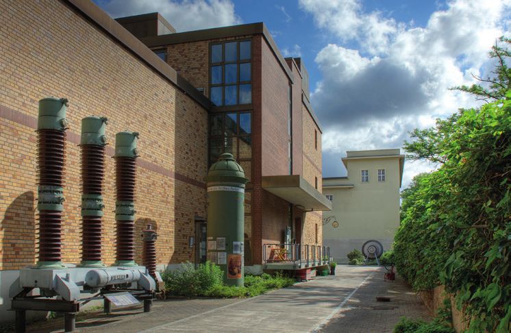
EUREC4A – ELUCIDATING THE ROLE OF
CLOUDS-CIRCULATION COUPLING IN
CLIMATE
The EUREC4A field study is an international project with over
40 partners led by the Max Planck Institute for Meteorology
in Hamburg and the French National Centre for Scientific
Research (CNRS) in Paris. As part of the campaign, four
research aircraft, four research ships, and ground-based
measuring equipment on Barbados were coordinated for use,
and the measurement results were combined with high-
resolution climate models and advanced satellite-based remo-
te sensing. The team is currently evaluating the data that they
collected on the measurement flights in early 2020. The sci-
entists involved in EUREC4A are focusing on four main points:
• C
loud configuration and feedback processes – investiga-
ting the impact of environmental conditions on cloud
structure, the mesoscale configuration of clouds, and
cloud feedback effects
A UNIQUE CLOUD • A
erosol and cloud physics – investigating the effects of
aerosols on cloud formation, structure, and properties – in
particular, the impact of dynamic processes on the micro-
COCKTAIL
physics of clouds
• Boundary layer dynamics – turbulence, mixing processes
• A
tmosphere-ocean interactions – examining exchange
processes
Investigating the interaction between clouds, weather and
climate with the HALO research aircraft. is because some of these clouds are relatively small and form over the
middle of the ocean, making it difficult to examine them more closely.
By Silke Groß The EUREC4A research campaign is one of the biggest projects to
investigate these clouds and their dependence on environmental
conditions. During a four-week measuring phase in early 2020, the
scientists were able to establish a comprehensive picture that will take
climate research an important step forward.
Hunting clouds at sea and in the air
T hink of Barbados, and you will no doubt find yourself dreaming of Caribbean beaches, palm
trees and sunsets. For the scientists working on the EUREC4A mission things are different. As
far as they are concerned, Barbados is, first and foremost, the place where air masses that have
Before the air masses of the trade winds reach the Barbados mainland,
low-level marine clouds form as they travel over the ocean – trade
wind clouds. These clouds are an important piece of the jigsaw for
Equipped with remote sensing instruments and dropsondes for mete-
orological measurements, the German High Altitude and Long Range
been carried over the Atlantic for days meet land for the first time. Therefore, they see it as the scientists investigating climate change, as they are highly sensitive to Research Aircraft (HALO) was able to get a close look at the structure
perfect location for atmospheric research. An international team has been investigating this their environmental conditions and thus to further global warming. of the entire lower atmosphere during its overflights. Adopting a
special mix of clouds and how it is being altered by climate change in the research project However, these types of clouds and their impact on the climate are circular flight pattern at an altitude of approximately nine kilometres,
EUREC4A (Elucidating the role of clouds-circulation coupling in climate). only described with great uncertainty in current climate models. This the researchers examined the clouds and the humidity – and the air
ATM OSPH E R I C R E S E AR C H DLRmaGazine 165 1 5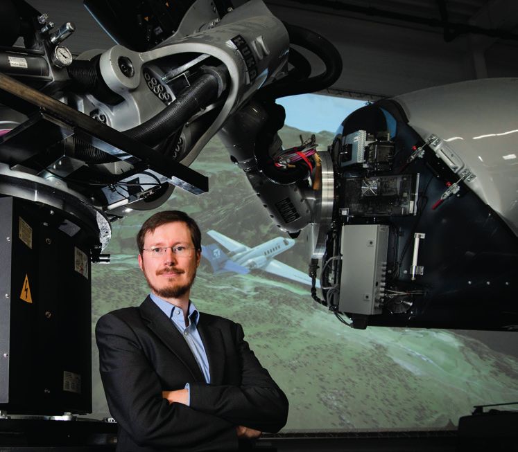
During the EUREC4A mission in February
2020 – a 360-degree image of the pilots,
Marc Puskeiler (left) and Stefan Grillenbeck
(right) with atmospheric researcher Manuel
HALO RESEARCH AIRCRAFT Gutleben in the flight deck.
HALO was equipped with remote sensing instruments for
the research campaign. On board were a radar, a lidar
(light detection and ranging), a spectrometer, radiometers
and meteorological dropsondes. For the measurements
over the ocean, the long flight time was particularly
decisive – a unique selling point of the research aircraft. It
flew the same circular flight path for nine hours. A further
advantage of HALO is its flight altitude: in previous
EUREC4A campaigns the aircraft carried out measurements
up to an altitude of 15 kilometres.
into operation within a very short space of time. The potential of the
radar system from Oberpfaffenhofen was evident from the very first
day of measurements, when it recorded the horizontal and vertical
POLARISATION DIVERSITY DOPPLER structure of clouds up to a distance of 250 kilometres. The team
worked around the clock in shifts to observe changes in the clouds
RADAR (POLDIRAD) over time throughout the day. The real-time measurement results
Wavelength/frequency: 5.5 centimetres / five Gigahertz enabled the pilots to head for the clouds over the Atlantic off the coast
of Barbados and to coordinate the research aircraft effectively.
Antenna diameter: five metres
Round-the-clock measurements
Technical features:
transmitting and receiving with any polarisation The scientists were particularly interested in the formation and evolu-
tion of the different cloud structures. To obtain answers, they had to
Field of application: measurement of precipitation look at the complete lifecycle of clouds, ideally before they had even
(shape, phase and velocity vector) formed. Cloud systems usually form at the end of the night and
change over the course of the day as they interact with incoming solar
radiation. This meant that it was important to get up early. During the
campaign, the HALO flights were staggered between 04:00 and 20:00
(the most active time for cloud systems). Flying multiple research
aircraft made it possible to extend these observations into the night.
Using the WP-3D, ATR-42 and HALO on a staggered schedule allowed
the scientists to observe environmental conditions and cloud formation
and development on an almost 24-hour basis.
flowing in and out of the weather system – important factors in deter- measuring five metres across, it provides information about clouds and If embarking on a night flight, for instance, the WP-3D would take
mining the processes of cloud formation. precipitation over the ocean at great distances. These measurement off at around 20:00. The ATR-42 and HALO followed at four-hour The aerosol and water vapour lidar implemented by the DLR Institute of
data were sent to the research aircraft in real time so that the scientists intervals. The scientists had to arrive at the airport approximately Atmospheric Physics
Below HALO, an ATR-42 – an aircraft operated by the French National and pilots could adapt their flight routes accordingly. three hours before the scheduled departure in order to prepare and
© DLR
Centre for Scientific Research (CNRS) – and a Twin Otter – a turboprop calibrate the instruments for the flights. The pilots, technicians and
aircraft operated by the British Antarctic Survey – analysed the proper- An obstacle course scientists who would be flying on board came to the hangar one
ties and structures of the clouds within the weather system. Flights hour before take-off. There was plenty to do in the intervening time
made by the WP-3D from the US supplemented the observations with The POLDIRAD cloud radar is usually installed on the roof of the Insti- – reviewing the systems one last time and discussing the flight
measurements made over the ocean further to the east. In addition tute of Atmospheric Physics at the DLR site in Oberpfaffenhofen. For sequence were crucial tasks. Those who were not part of the crew
to the aircraft measurements, four research ships – the German the EUREC4A mission, the system was dismantled and safely stowed would leave the aircraft 15 minutes before take-off, and then it
research vessels Meteor and Maria S. Merian, the US research ship in five shipping containers for the Atlantic voyage to Barbados, which would be ‘all systems go’.
Ronald H. Brown and the French research ship L’Atalante – studied the took several months. Of course, it was practically inevitable that not
ocean and atmosphere around Barbados. The research ships served everything would go to plan. While HALO flew according to a fixed flight pattern, the ATR-42
as remote sensing and in-situ platforms equipped with radiosondes, focused on deliberately approaching and examining clouds and areas
lidar and radar technology, kite balloons and uncrewed flight systems. The team encountered numerous difficult moments in the process of of precipitation – a difficult feat on a night flight. Fortunately, the
getting the equipment to its destination in the Caribbean – from the POLDIRAD cloud radar was operational and able to supply the neces-
Approaching clouds in a controlled way and taking samples requires complex transport logistics, to altered import and customs procedures sary information directly to the aircraft. After the flights, the aircraft
knowing their exact position. To that end, scientists from the DLR in Barbados. Thanks to support from colleagues on the ground, landed back at Barbados Airport. The data were then saved and the
Institute of Atmospheric Physics brought their Polarisation Diversity customs released the containers just in time for the start of the team discussed the performance of the individual instruments, prob-
Doppler radar (POLDIRAD) system to the island. With an antenna campaign. Everyone worked hard to set up, test and put POLDIRAD lems that occurred during the flight, and the achievement of the Silke Groß in the HALO research aircraft
16 DLRmaGazine 165 AT M O SP HE R IC R E S E AR C H ATM OSPH E R I C R E S E AR C H DLRmaGazine 165 1 7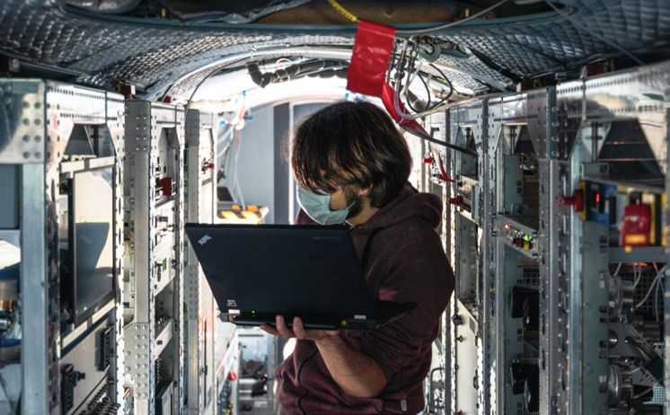
© Max Planck Institute for Meteorology
THE CLOUD COLLECTOR
© Max-Planck-Institut für Meteorologie, Foto: F. Batier
In conversation with Bjorn Stevens, Director of the Max Planck
Institute for Meteorology in Hamburg and Head of the EUREC4A
research campaign.
Professor Stevens, you have led the largest international cloud
research campaign to date. What were the challenges?
:: EUREC4A is the result of more than a decade of work, largely in
close collaboration with my French colleague, Sandrine Bony, and
a particularly cooperative and creative community of German
scientists from DLR and various universities who have worked in
recent years to establish HALO as one of the world's most
outstanding research platforms. So, the study went very well.
Nevertheless, we had challenges. An interesting one arose of the
different cultures of scientific practice among scientific groups. In
atmospheric research, we are often interested in certain
The Meteorological Observatory
BCO (Barbados Cloud Observatory)
operated by the Max Planck
“What you do not measure sometimes
Institute for Meteorology Hamburg, provides more information than collected the data required to answer this question. What struck
located at Deebles Point, Barbados. me most about the campaign was that changing circumstances
what you measure” help us see each other in a different light – be it that young scien-
tists took on responsibility or that we received local support to
phenomena and then look for exactly these phenomena. In other carry out our measurements. In terms of nature, I also have indel-
scientific objectives, before finally heading off for a well-deserved Barbados. It is playing an important role in weather forecasting in words, we are chasing a signal. But this gives a distorted picture ible memories of the campaign – the impact of the winds on
rest at the end of a long day. the Caribbean, as it is currently the only functioning weather radar of how often and how strong effects occur. For a statistical study water as a layer of air over the ocean cooled by evaporating rain,
on the island. The Oberpfaffenhofen team plans to head back to the of the kind we wanted to conduct, the biggest challenge was or the way the clouds flowed into the colours of the setting sun.
In addition to the HALO measurements, the researchers had planned Caribbean in autumn 2020 to continue its weather radar convincing team members again and again that what you do not
to use POLDIRAD to monitor the development of the clouds over the measurements. measure sometimes provides more information than what you Where would you like to travel next for research and why?
ocean over a longer period of time. Unfortunately, the team had to measure. To see the big picture, you also need to understand :: In August 2023 or 2024 I hope to find myself near 35 degrees
leave Barbados earlier than they had envisaged due to the Corona- Silke Groß works at the Lidar Department of the DLR Institute of Atmospheric what and how often things you expect to happen are not in the west and 10 degrees north, in the North Atlantic Ocean between
virus pandemic. The POLDIRAD weather radar equipment is still in Physics and leads the Radar and Lidar Synergies working group. picture. So, things become meaningful through their absence. Venezuela and Guinea. There, in the deep tropics, air masses from
the southern and northern hemispheres meet and create violent
What do you remember most about the campaign? And rain bands, the formation of which releases enormous amounts
what did you learn about cloud formation and its effect on of energy that influence the climate worldwide.
the climate?
:: It is too early to say exactly how clouds influence the pace of This interview was conducted by Falk Dambowsky, a Media Relations editor
global warming. However, we are very confident that we have at DLR.
PREPARATIONS FOR THE EARTHCARE CLIMATE
MISSION:
EarthCARE (Earth Cloud Aerosol Radiation Explorer) is a research
© Max Planck Institute for Meteorology
mission devised by the European Space Agency (ESA) and the Japa-
nese Space Agency (JAXA) to examine aerosols and clouds, as well
as their interactions and climate impact. Equipped with sophistica-
ted lidar (light detection and ranging) technology, a Doppler cloud
radar (radio detection and ranging) and sensors for measuring
radiation, it is one of the most complex satellites for researching Planned launch:
aerosols and clouds. 2022
In the EUREC4A campaign, the HALO research aircraft flew with an Duration:
almost complete suite of EarthCARE-like instruments (radar, lidar, 3 years, plus 1 year of reserve fuel
spectrometer and radiometer). It is one of only two research aircraft
worldwide for which this is possible. Such measurements emulate Orbit:
future EarthCARE studies and are providing some initial insight into Altitude 393 kilometres , Sun-synchronous
how the instruments interact. This is also enabling the testing and
further development of algorithms to be able to assess the strengths Instruments
and weaknesses of future satellite measurements – an important step Doppler radar (94 GHz), high spectral resolution lidar (355 nm),
in preparing for the future satellite mission. multispectral imaging spectrometer, broadband radiometer
18 DLRmaGazine 165 AT M O SP HE R IC R E S E AR C H ATM OSPH E R I C R E S E AR C H DLRmaGazine 165 1 9© DLR
Measurement instruments are prepared for
use in the HALO research aircraft
March–April
industry and air transport have on the atmosphere, and how much
have these emissions been reduced by the restrictions put in place in
response to the pandemic? How does air traffic affect the upper
troposphere? These are the central questions being addressed by the
BLUESKY project, which was launched at short notice during spring
2020 under the leadership of DLR and the Max Planck Institute for
Chemistry. Prior to the campaign, a decrease in concentrations of
nitrogen dioxide in industrial hubs and a marked reduction in contrails
over Europe had already been demonstrated by satellite measurements
evaluated by DLR. This gave rise to the assumption that the emissions
of other trace gases and aerosols − microscopic particles that form
when fossil fuels are burned, among other causes, and which have a
bearing on cloud formation – had also been reduced. Unlike satellite March–April
images, which are taken from a considerable distance, measurements
made on board research aircraft can deliver data with much greater
precision and higher resolution, thus providing a more complete
picture of the situation.
TAKING TO THE SKIES IN
A bright blue sky
Following the initial measurement flights over Germany – from Ober-
pfaffenhofen to the Ruhr region and over Berlin and Hamburg – the
TIMES OF A PANDEMIC
two research aircraft flew to Milan. This region in the Po Valley is an Even before the BLUESKY flights, DLR’s Earth Observation Center (EOC) detected
important industrial and business location in Northern Italy. Due to the a sharp drop in nitrogen dioxide over Europe compared to the previous year. The
far-reaching pandemic measures introduced by the Italian government, data originate from the TROPOMI sensor on board the European Copernicus
the chances of measuring a corona-induced reduction of air pollutants Sentinel-5P satellite. Nitrogen dioxide is an indicator of air pollution from
in the boundary layer were particularly good there, similar to those industrial activities and road traffic.
above the Ruhr area. After a temporary, significant drop in road traffic
in the weeks of the lockdown, cars were already visible on the roads
again with the loosening of the restrictions, and factories gradually CONCENTRATION OF NITROGEN DIOXIDE IN
increased their production. However, one could not yet speak of THE ITALIAN PO VALLEY
The BLUESKY project investigates the atmosphere during the ‘normality’.
Credit: DLR-EOC/ EUMETSAT AC-SAF
Coronavirus lockdown The BLUESKY team was particularly interested in the emissions from 1,2
Specified in 1015 molecules/cm2
urban agglomerations. On this day, the exhaust plume from Milan drifted 1,0
NO2 in the troposphere
By Falk Dambowsky and Valerian Hahn westward, spreading across the surrounding area and accumulating in
the foothills of the Alps. Directly above the city and in the surrounding 0,8
region, the Falcon’s instruments recorded high aerosol and particulate
0,6
matter levels in the boundary layer at an altitude of one to two kilome-
D LR’s Falcon research aircraft has seen a lot in its time – it has been used for scientific purposes for over four decades.
Ten years ago, it was deployed as a ‘volcanic ash hunter’ when air traffic over Europe largely came to a standstill
following the eruption of the Icelandic volcano Eyjafjallajökull. In the aftermath, the Falcon conducted measurement
tres. In contrast to these boundary layer measurements, the two DLR
research aircraft flew at cruising altitudes between 10 and 12 kilometres
above the Atlantic off the Irish coast in two flights. There, the team
0,4
0,2
flights through the ash cloud, acquiring data that would prove important in assessing the situation and determining carried out measurements on the few remaining emissions from the 80
0,0
the right moment for European air traffic to resume operations. In May 2020, it embarked on another very special percent reduction in air traffic. 2016 2017 2018 2019 2020
mission – to examine the sky during the COVID-19 lockdown, while most aircraft remained on the ground.
The airspace over western Ireland is flown through by passenger and January February March April May
cargo aircraft at the beginning of their North Atlantic routes on their
Development of tropospheric nitrogen dioxide over the Italian Po Valley from
way to America. The influences of air traffic are particularly easy to 2016 to 2020, measured with the GOME-2 sensor on board the European
The Falcon was not alone as it performed these remarkable flights. It was accompanied by the High Altitude and Long Range measure in the clean air over the ocean. HALO and Falcon’s measure- weather satellite MetOp. The values from March to April 2020 are significantly
Research Aircraft (HALO), which is also stationed at DLR’s site in Oberpfaffenhofen. The German research team, which included ments focused particularly on nitrogen oxides and aerosols from reduced compared to previous years, while the values in May 2020 increased
many scientists from the DLR Institute of Atmospheric Physics, aimed to study the atmosphere during the lockdown resulting passenger flights. The first results of the Falcon showed a slight decrease again after the lifting of the lockdown measures.
from the Coronavirus pandemic – a time of less air traffic and, as such, reduced air pollution. of aerosols in the upper troposphere. Among other influences, such
lower aerosol concentrations in the air make the sky appear bluer.
Overseeing the mission while working remotely
Situation is comprehensively documented
Before the two research aircraft could take off, they had to be prepared at the DLR Flight Experiments Facility in Oberpfaffenhofen.
Numerous instruments were installed and adapted as the aircraft were prepared for the upcoming mission under challenging Falcon and HALO took off for BLUESKY a total of 20 times from their
conditions. This task was made somewhat easier for the team because the measures to equip the aircraft for other, previously Bavarian home airport in May and June 2020. The data acquired
planned, flight campaigns were still in place. Preparatory work for these missions had been suddenly halted due to the intro- during these missions will be evaluated by the end of the year. The
duction of COVID-19 precautionary measures, and their planned flights postponed indefinitely. This meant that many important analyses will include comparative data from previous HALO research
instruments had already been installed on HALO and Falcon, and only a few had to be newly installed and prepared. The flight campaigns on air traffic emissions and emissions from conurba-
COVID-19 precautionary measures forced experts across DLR to find ground-breaking solutions. Campaign organisation and tions. The coming year will also be interesting. There will be further
certification activities for the aircraft and their instruments now had to be conducted from the scientists’ desks at home. In measurement flights that the researchers hope will document the
order to get the aircraft flying as quickly as possible despite the restrictions, while also protecting the people involved, the situation after the pandemic.
on-site staff worked in daily shifts with minimal personnel. Wherever possible, instruments were prepared to allow monitoring
and control from the scientists’ home offices during the preparations and the research flights themselves. Falk Dambowsky is an editor in DLR Media Relations.
Despite its ramifications, the pandemic represents the opportunity of a century for scientists to measure trace gases Valerian Hahn is a doctoral student working in the field of Cloud Physics at the DLR
and aerosols in the air above European cities and at cruising altitude on flight paths. What impact do emissions from Institute of Atmospheric Physics. Measurements in the clouds above the Po valley
ATM OSPH E R I C R E S E AR C H DLRmaGazine 165 2 1You can also read