Alameda County - Combined
←
→
Page content transcription
If your browser does not render page correctly, please read the page content below
Alameda County

   [Narrative summary provided by the Alameda County Transportation Commission.]

The COVID-19 pandemic reshaped travel demand and the way people use the
transportation system in Alameda County; long-standing travel patterns have shifted and
there is great uncertainty about the future. For example, transit ridership plummeted at
the start of the pandemic across all operators; some riders have returned, but that
recovery has been in fits and starts as case counts have risen and fallen. No transit agency
has reported a new stable ridership state. Additionally, disruptions to the global supply
chain have rippled through goods movement in Alameda County. Even the most stable
indicators, like freeway congestion, have changed in fundamental ways since the start of
the pandemic. Peak-period freeway speeds have increased (indicating less congestion),
even as volumes in many places are back to pre-pandemic levels.

Given that much is still in flux, the transportation statistics reported below reflect pre-
pandemic conditions. However, the vast majority of the multimodal roadway,
highway/freeway, rail, and goods movement infrastructure described below is still
operating and needs for upgrades and improvements exist throughout the system.
Alameda CTC and our partners are aware that planning and project delivery of these
improvements needs to respond to long-standing needs while also seeking to be resilient
against multiple potential future trends.

County Overview

Located at the heart of the nine-county San Francisco Bay Area, Alameda County is the
second-largest county in the Bay Area, with a population of over 1.67 million. In 2019, the
extensive transportation network of roads, rails, buses, trails and pathways carried roughly
1.2 million commute trips daily to, from, within, and through the county, supporting
economic growth in the Bay Area, California, and the rest of the nation. The county’s
transportation system is multimodal, with non-auto trips on the rise, representing 30% of
the overall mode share in 2019.

         Draft 2023 TIP                      S3 - 1                                July 5, 2022
Roads and Highways

Alameda County roadways move people and goods within the county and beyond and
support multiple transportation modes. As regional economic and population growth
increase demand for goods and services, a variety of modes, including cars, transit, bikes,
and trucks, are competing to access the same facilities.

   •      The majority of Alameda County’s
          3,978 road miles are highways,
          arterials and major local roads
          that provide access to housing,
          jobs, education, and transit. Forty
          percent of daily trips in Alameda
          County are carried on arterials and
          major roads.
                                                Pictured: Travelers have made over 14.5 million trips on the I-580
   •      Historically, about five of the Bay
                                                Express Lanes since opening in February 2016.
          Area’s top 10 most-congested
          freeway segments have been in
          Alameda County.

   •      Congestion in Alameda County is compounded by the large amount of vehicle, rail,
          and freight travel through Alameda County between the origins and destinations
          of San Joaquin, Contra Costa, Santa Clara, San Francisco, and San Mateo counties.

Transit

Transit provides access to work, school, recreation, medical appointments, and other
important destinations in Alameda County and includes rail, bus, ferry, and shuttle service
provided by public and private operators.

   •      In 2019, Alameda County had a transit commute share of 18%, the second highest
          in the state, with approximately 96 million riders boarding transit annually.

           Draft 2023 TIP                       S3 - 2                                                  July 5, 2022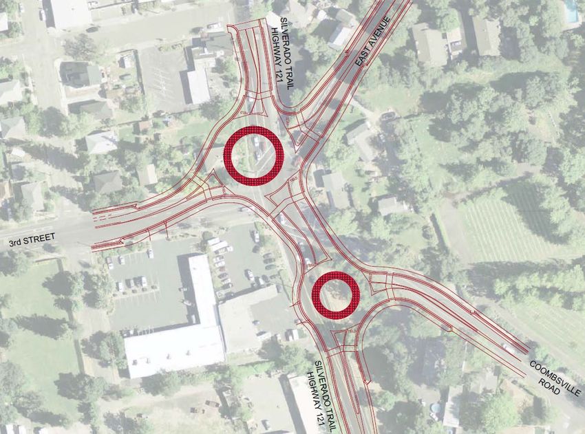
•   The Alameda-Contra Costa Transit District
       (AC Transit) served 49% of annual
       countywide transit ridership on 151 bus
       routes.

   •   The San Francisco Bay Area Rapid Transit
       District (BART) served 46% of annual
       countywide transit ridership, with 22 of
       BART’s 50 stations located in Alameda
       County.

   •   San Francisco Bay Ferry service was also      Pictured: AC Transit picking up passengers on a major arterial.
       growing with the county’s three ferry
       terminals on average serving about
       10,000 commuters each weekday in 2019.

Goods Movement

Alameda County serves as a gateway to the world for goods movement to and from the
county, Bay Area, Northern California, and beyond.

   •   Alameda County contains the core of the Bay Area/Northern California freight and
       passenger rail systems, and the demand for both freight and passenger service has
       grown over time.

   •   In 2019, the Port of Oakland was the eighth busiest port in the nation by volume
       and handled 99.9% of shipping container volume for Northern California.

   •   In addition, Oakland International Airport and two major Class I railroads support
       international and domestic trade.

        Draft 2023 TIP                      S3 - 3                                              July 5, 2022
•     Key interregional and
         intraregional     truck
         corridors in Alameda
         County include I-80, I-
         238, I-580, I-680, and
         I-880. In 2019, these
         corridors carried over
         20,000 trucks of all
         classes per day, on
         average.
                                   Pictured: Truck and rail queues at the 8th busiest port in the nation, the Port of Oakland.

Planning Framework

Several plans guide transportation development and funding decisions in Alameda
County and are developed with input from the public, community groups and partner
agencies across the county. Every four years, Alameda CTC adopts a Countywide
Transportation Plan. The 2020 Countywide Transportation Plan (2020 CTP), adopted in
November 2020, articulates the vision for Alameda County’s transportation system over a
30-year planning horizon and provides input to the current regional plan - Plan Bay Area
2050. The 2020 CTP reinforces the vision of the previous two CTPs and has four goals that
further describe the vision. The vision and goals were foundational in prioritizing projects
and strategies to advance over the first 10 years of the plan horizon.

Vision statement:

Alameda County residents, businesses and visitors will be served by a premier
transportation system that supports a vibrant and livable Alameda County through a
connected and integrated multimodal transportation system promoting sustainability,
access, transit operations, public health, and economic opportunities.

Goals:

   1. Accessible, Affordable, and Equitable. Improve and expand connected
         multimodal choices that are available for people of all abilities, affordable to all
         income levels, and equitable.

          Draft 2023 TIP                              S3 - 4                                                  July 5, 2022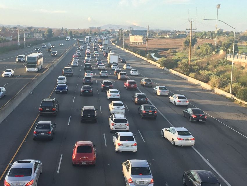
2. Safe, Healthy, and Sustainable. Create safe multimodal facilities to walk, bike, and
       access public transportation to promote healthy outcomes and support strategies
       that reduce reliance on single-occupant vehicles and minimize impacts of
       pollutants and greenhouse gas emissions.

   3. High Quality and Modern Infrastructure. Deliver a transportation system that is
       of a high quality, well-maintained, resilient and maximizes the benefits of new
       technologies for the public.

   4. Economic Vitality. Support the growth of Alameda County’s economy and vibrant
       local communities through a transportation system that is safe, reliable, efficient,
       cost-effective, high-capacity, and integrated with sustainable transit-oriented
       development facilitating multimodal local, regional, and interregional travel.

The county’s Congestion Management Program, updated in October 2021, describes the
strategies to assess, monitor, and improve the performance of the county's multimodal
transportation system; address congestion; and protect the environment with strategies
to help reduce greenhouse gas emissions.

The 2014 Transportation Expenditure Plan (TEP), funded by the local Measure BB sales tax
for transportation approved by Alameda County voters in November 2014, spans 2015-
2045 and plans for essential transportation improvements in every city throughout the
County. The 2000 Measure B TEP sunset in 2022 after delivering improvements in every
city throughout the County. Over the course of the 20-years, the Alameda CTC leveraged
over $1.4 billion in local Measure B funds to deliver more than $4.1 billion in projects and
programs to improve transportation and alleviate congestion in Alameda County. In
addition, the 2010 Vehicle Registration Fee (VRF) TEP includes local road, pedestrian and
bicyclist safety, transit, and transportation technology improvements.

Other plans that guide transportation development in Alameda County are the latest
Priority Development Area (PDA) Investment and Growth Strategy, adopted in January
2022, and the Active Transportation Plan, adopted in May 2019.

The 2022 Comprehensive Investment Plan (CIP), most recently adopted in July 2021,
brings all these long-range and countywide plans into the near term by focusing on
investments over a five-year programming and allocation window. The purpose of the CIP
         Draft 2023 TIP                      S3 - 5                                July 5, 2022
is to facilitate strategic programming and allocation of all fund sources under Alameda
CTC’s programming responsibilities, which include federal, state, regional, and local
sources.

Alameda County TIP Project Highlights

The Alameda County projects in the 2023 TIP are targeted to improve the quality and
efficiency of the transportation system by addressing the county’s diverse transportation
needs as identified in the aforementioned transportation plans, as well as the region’s
current RTP/Sustainable Communities Strategy, Plan Bay Area 2050.

Strategic highway, rail, and major arterial investments are targeted throughout the county
to address identified gap closures, operational, and safety needs. In the more densely
populated northern and central parts of the county, various improvements are identified
for the I-80 and I-880 corridors, including the GoPort program of projects to improve
truck and rail access to the Port of Oakland (7th Street Grade Separation East and West
projects and Freight Intelligent Transportation Systems and Technology Master Plan) to
support improved goods movement in the county and a series of interchange
improvements on I-80 at Gilman Street and Ashby Avenue. On I-880, interchange
improvements are progressing at Winton Ave, Industrial Parkway West, and Whipple
Road. In eastern Alameda County, highway projects include express lane improvements
in the I-680 corridor, including a 9-mile northbound express lane over the Sunol grade,
and a gap closure project that will lead to a 48-mile continuous southbound express lane
on I-680. Work is also moving forward on the last set of highway improvements to State
Route 84, including widening SR 84 to expressway standards and improvements at the I-
680/SR 84 interchanges. In southern Alameda County, improvements include the State
Route 262 cross connector between I-680 and I-880. The first phase of the Rail
Transportation Enhancement Program (RSEP) will improve safety at 28 at-grade rail
crossings and two trespass locations along the Union Pacific rail tracks within six rail
corridors in Alameda County.

           Draft 2023 TIP                   S3 - 6                               July 5, 2022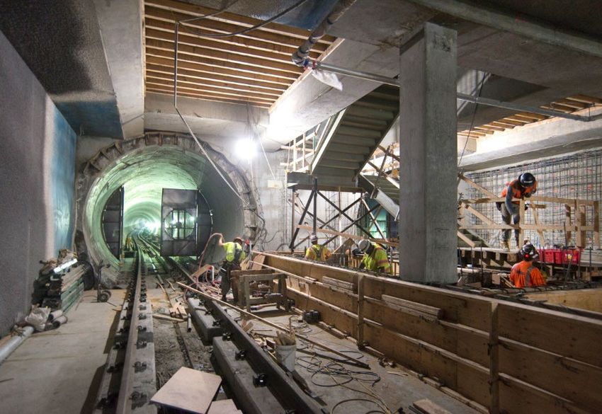
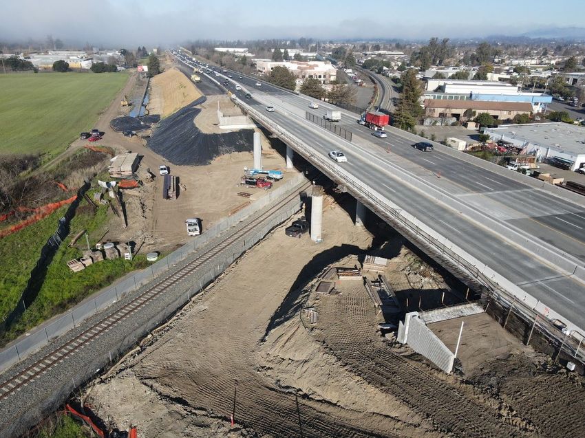
Pictured: I-680/84 Interchange Improvements project under construction

To increase the use of alternative transportation modes, funding is also directed toward
various transit, bicycle and pedestrian, and multimodal improvements on arterials and
local roads throughout the county. These projects include the I-880 Oakland Alameda
Access project to reduce conflicts between regional and local traffic and enhance bicycle
and pedestrian accessibility and connectivity, multimodal arterial improvements along
San Pablo Avenue and E. 14th Street, bus rapid transit (BRT), and transit- and Priority
Development Area (PDA)-supportive projects such as the East Bay Greenway and
accessibility improvements and modernization of BART stations. Additionally, a large
investment in transit rehabilitation and fleet replacement is primarily directed toward AC
Transit and BART.

Funding for the Alameda County TIP projects comes from a variety of local, regional, state,
and federal sources, resulting from local, regional, and statewide partnerships to develop
strategic funding packages, establish legislation, and prioritize transportation investments
to advance project delivery. As a result, record-level investments are improving Alameda
County’s transportation system, including the local 2014 Measure BB, which will provide
$8 billion in transportation improvements over the next 30 years.

         Draft 2023 TIP                                     S3 - 7                                 July 5, 2022
Contra Costa County

          [Narrative summary provided by the Contra Costa Transportation Authority]

Overview
While the Bay Area has more than doubled in population since 1950, Contra Costa County
has grown even faster, more than tripling in population between 1950 and 2010. The
Metropolitan Transportation Commission and the Association of Bay Area Governments
(MTC/ABAG) now estimates that Contra Costa has a population of 1,128,660 people with
approximately 414,290 jobs. Contra Costa is forecast to add 258,635 residents between
2020 and 2040, a 23% increase. The growth in population coincides with a growth of
75,775 new households forecasted by 2040. Job growth in Contra Costa is expected to
add 83,825 new jobs, a 20% increase. 1

The Contra Costa Transportation Authority (CCTA) serves as the Congestion Management
Agency (CMA) for the county. As the CMA, CCTA prepares a Congestion Management
Program and updates it biennially, prepares a recommended list of projects for funding
through the State Transportation Improvement Program (STIP), and works with other
CMAs and regional and State agencies to address transportation and growth issues in the
region and the State. CCTA also manages Measure J, the 2004 half-cent sales tax that
succeeded 1988’s Measure C, which first established Contra Costa’s transportation
improvement and growth management program. Measure J, which began on April 1,
2009, extended the sales tax for another 25 years.

The Vision for Contra Costa
As part of the development of its 2017 Countywide Comprehensive Transportation Plan,
or CTP, CCTA refined its vision for the future of the transportation system in Contra Costa:

          Strive to preserve and enhance the quality of life of local communities by
          promoting a healthy environment and strong economy to benefit all people and

1
    MTC/ABAG Plan Bay Area 2040 Projections 2018

            Draft 2023 TIP                         S3 - 8                          July 5, 2022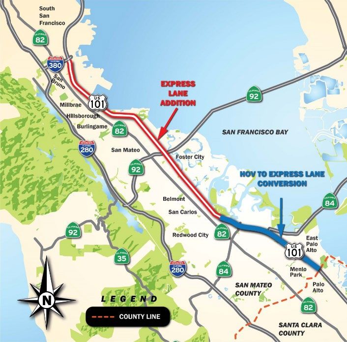
areas of Contra Costa, through (1) a balanced, safe, and efficient transportation
network, (2) cooperative planning, and (3) growth management. The transportation
network should integrate all modes of transportation to meet the diverse needs of
Contra Costa.
To achieve this vision, CCTA has identified five goals and 31 strategies to help carry them
out. The five goals are:
1. Support the efficient and reliable movement of people and goods using all
available travel modes;
2. Manage growth to sustain Contra Costa’s economy, preserve its environment and
support its communities;
3. Expand safe, convenient, and affordable alternatives to single-occupant vehicles;
4. Maintain the transportation system; and
5. Continue to invest wisely to maximize the benefits of available funding.
Achieving the vision and goals will require finding the right balance among the different,
and sometimes competing, needs of Contra Costa’s residents and businesses, including:
Improving the regional system of roads, transit, trails, and pathways while ensuring
that the existing system is well maintained;
Balancing the needs of through-traffic with the access needs and quality of life of
adjoining neighborhoods and business areas;
Recognizing the differing needs and situations of Contra Costa’s residents and
subareas, while developing a workable approach to countywide and regional
initiatives;
Where feasible and beneficial, improve the capacity of roadways, while recognizing
that these improvements will not, in the long run, eliminate congestion; and
Supporting and encouraging the use of transit, carpools, bicycling, and walking,
often within limited rights-of-way.
Finding this balance will require cooperation among the jurisdictions of Contra Costa and
the support of residents and the business community.
Draft 2023 TIP S3 - 9 July 5, 2022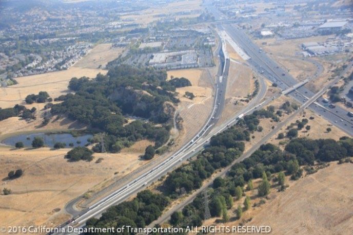
CCTA is in the process of updating the five Action Plans for the four subregions in the
County by focusing on innovative ideas to enhance Contra Costa’s transportation network
including   emphasis on     vehicle miles travelled    (VMT) reduction,     multi-modal
transportation (roadways, transit, bicycle/pedestrian), and non-modal categories such as
equity, safety, and climate change.

The development of the CTP for 2023 will follow with the primary overarching goals of: 1)
Relieving Traffic Congestion on Highways and Interchanges, 2) Make Bus, Ferry, Passenger
Train, and BART Rides Safer, Cleaner, and More Reliable, 3) Provide Access and Safe
Transportation for Children, Seniors, Veterans, and People with Disabilities, and 4)
Improve Transportation in our Communities.

Contra Costa TIP Projects
The projects in the proposed TIP support the goals CCTA has adopted, especially the first
and third goals, as described on the previous page:

   1. Support the efficient and reliable movement of people and goods using all
      available travel modes
   3. Expand safe, convenient and affordable alternatives to single-occupant vehicles

Support efficient and reliable Movement on Highways and Arterial Roads
One of the highest-profile Contra Costa County project in the 2023 TIP focused on
enhancing vehicular movement is future phases of the I-680/SR4 Interchange
Improvement project. The project will reduce congestion and improve operations along
SR4 and I-680 in the vicinity of the interchange. The 2023 TIP also includes the suite of
projects making up Innovate 680, including the I-680 Northbound Express Lane
Completion project, I-680 Part Time Transit Lane, and I-680 Coordinated Adaptive Ramp
Metering (CARM). Other projects included in the TIP that are currently in the development
phase include SR4 Operational Improvements and SR239.

Numerous arterial and interchange improvement projects are also planned to relieve
congestion and improve circulation on city streets. These projects include future phases
of improvements to I-80/Central Avenue in Richmond, I-80/San Pablo Dam Road in San
Pablo, and the widening of Brentwood Boulevard (Phase 2) in Brentwood.

        Draft 2023 TIP                     S3 - 10                              July 5, 2022
Expand safe, convenient, and affordable alternatives to the single-occupant vehicle
The 2023 TIP includes a number of projects that support the transit system, including the
Hercules Intermodal Station, Concord BART Modernization, L Street Pathway to Transit in
Antioch, and El Cerrito del Norte Transit Oriented Development Complete Streets project
in El Cerrito.
The 2023 TIP also programs funding for several pedestrian and bicycle projects that will
close gaps and/or improve pedestrian and bicyclist safety in Contra Costa. These include
the Iron Horse Trail Bike and Pedestrian Overcrossing in San Ramon, the Safe Route to
School Pedestrian Enhancement project at Lincoln Elementary in Richmond, the BART
Pedestrian Bicycle Connectivity Project in Pittsburg, and the Mokelumne Trail Bike and
Pedestrian Overcrossing in Brentwood.
Contra Costa projects in the 2023 TIP also support the goals of Plan Bay Area 2050, the
Metropolitan Transportation Commission’s (MTC) Regional Transportation Plan and
Sustainable Communities Strategy, as shown below.
• Affordable: The I-680/SR4 Improvements will provide access to the Concord Naval
Weapons Station where significant future housing development in the County is
proposed.
• Connected: The suite of projects under the Innovate 680 Program, including
Northbound I-680 Express Lane Completion, Part Time Transit Lane, and Advanced
Technology will provide a safe and multimodal system for users.
• Diverse: The 2023 TIP includes projects in all regions of Contra Costa County.
• Healthy: The 2023 TIP includes active transportation projects such as Iron Horse Trail
Bike and Pedestrian Overcrossing, BART Pedestrian Bicycle Connectivity Project in
Pittsburg, and Mokelumne Trail Bike and Pedestrian Overcrossing that promote active
transportation.
• Vibrant: SR 239 is intended to provide better access to east Contra Costa County, which
will make the region more attractive for job creation.
Draft 2023 TIP S3 - 11 July 5, 2022Marin County
[Narrative summary provided by the Transportation Authority of Marin]
Marin County TIP Projects
Marin County is linked to San Francisco by the Golden Gate Bridge and to the East Bay by
the Richmond-San Rafael Bridge. It is bordered on the north and northeast by Sonoma
County and on the west by the Pacific Ocean. Marin is the slowest growing county in the
region in terms of population. Marin currently has approximately 260,000 residents. Marin
residents enjoy the county’s small-town atmosphere and close connections to
recreational areas. Over 90% of the growth anticipated in Marin County will occur within
the urban corridor, along Highway 101.
Although Marin County is usually thought of as a suburban residential and recreational
area, ranching and dairy farming are also major features of the rural areas of West Marin.
Industry in the county includes movie and video production, computer software,
communications equipment, bioengineering, financial services, printing, and the
manufacture of plastic products, ceramics, and candles.
To address Marin County’s most immediate transportation needs, residents, elected
officials, and planners agreed, after extensive public meetings, that local funding was
indispensable. As a result, Measure A, a ½ cent transportation sales tax, was approved in
November 2004, generating approximately $25 million annually for 20 years. In November
2018, Marin voters approved the renewal and 30-year extension of the 1/2-cent
transportation sales tax and expenditure plan under Measure AA.
Draft 2023 TIP S3 - 12 July 5, 2022Marin County voters also passed Measure B in November 2010 to increase the annual
vehicle registration fee by $10 to help fund transportation improvements, generating
approximately $2.3 million annually.
In addition to the sales tax and vehicle registration fee measures, Marin County has
tapped into other regional, state, and federal funds to achieve the county’s transportation
goals. Marin County transportation projects support the adopted goals and vision of the
Regional Transportation Plan and Sustainable Community Strategy (RTP/SCS), Plan Bay
Area 2050.
Local matching funds will also help Marin County develop and implement plans to provide
a variety of quality multi-modal transportation options for Marin residents, including safe
routes to school projects, crossing guard programs, commute alternative and alternative
fuel programs, improved bicycle and pedestrian access, senior and disabled mobility, and
enhanced transit services.
Other notable projects of regional significance in Marin County include:
• Marin Sonoma Narrows (MSN) – The overall project scope includes upgrading
US-101 from expressway to freeway, extending approximately 16 miles of high
occupancy vehicle (HOV) lanes from SR-37 in Novato in Marin County to north of
Corona Road Overcrossing in Petaluma in Sonoma County; constructing new
interchanges, frontage roads, and pedestrian/bicycle facilities; and installing traffic
operation system (TOS) improvements such as traffic monitoring stations and ramp
metering on the mainline and ramps. The last substantial contract for the MSN
project (Contract B7) started construction in 2022. This project is included in Plan
Bay Area 2050.
Draft 2023 TIP S3 - 13 July 5, 2022• North/South Greenway Gap Closure Project (Central Marin Ferry Connection
(CFMC) Phase II) – This project is the next phase of an overall effort to close a gap
in the non-motorized transportation network in central Marin. The proposed multi-
use path will connect the bicycle and pedestrian bridge crossing Sir Francis Drake
Blvd with the pedestrian over-crossing of Highway 101 at the Lucky Drive On/Off
Ramps. The project segments are in various levels of the project delivery stage,
from the construction phase to the final design phase. This project is included as a
programmatic category of improvements in the blueprint for the Plan Bay Area
2050.
• Sonoma-Marin Area Rail Transit (SMART) Rail and Pathway Project – In 2008,
voters in Marin and Sonoma Counties passed Measure Q to collect a one-quarter
percent sales tax for the construction and operation of the SMART District
commuter rail and non-motorized pathway project in both counties. Construction
began on Phase 1 of the project in 2012 and the start of revenue rail service
commenced in August 2017. SMART’s initial 43 miles of rail corridor includes 10
stations, from the Sonoma County Airport to Downtown San Rafael. Future
extensions will include Windsor, Healdsburg, and ultimately Cloverdale. The full
project will provide 70 miles of passenger rail service, connecting SMART
passengers with jobs, education centers, retail hubs and housing along the
Sonoma-Marin corridor, and a bicycle-pedestrian pathway. The pathway elements
of this project are included as a programmatic category of improvements in the
blueprint for Plan Bay Area 2050.
• Richmond-San Rafael Bridge Improvements – The Bay Area Toll Authority
(BATA) completed a $74 million project to improve access to Eastbound I-580
across the Richmond-San Rafael Bridge in April 2018. Additionally, the project
Draft 2023 TIP S3 - 14 July 5, 2022added a multi-use path to the upper deck providing bicycle and pedestrian access
between Marin and Contra Costa Counties. As a part of this portion of the work,
the Main Street on-ramp was reconfigured in Marin and a retaining wall
reconstructed in Richmond. The upper deck multi-use path features a 10-foot wide
barrier-separated path from Main Street to Marine Street along the north part of
I-580. The path provides access to an additional path to be constructed to Point
Molate. Improvements will be made along Francisco Boulevard East in Marin and
along Sir Francis Drake on-ramp to I-580 to better access the path. Usage data is
being gathered to assist with the evaluation of the pilot project. This project is
included in the blueprint for Plan Bay Area 2050.
• Northbound US 101 to Eastbound I-580 Direct Connector Project - Currently
traffic must utilize local roads to transition from northbound US 101 to cross the
bridge to Richmond. Funding in the amount of $135 million has been made
available from Regional Measure 3. An additional $16.5 million was approved by
Marin County voters as part of the 2018 Transportation Sales Tax for project
acceleration and local features. The local funds have allowed the project to proceed
while the RM-3 funds are held up due to litigation. A robust public outreach
process was recently completed to explore alternatives prior to the formal start of
the Project Initiation Document with Caltrans. A key feature of all alternatives is
that the project will not preclude completion of the westbound I-580 to
southbound US 101 direct connector when that project is initiated. The process
includes multiple stakeholders, multiple jurisdictions, and elected officials. The
formal Project Study Report, Project Report, and EIR are expected to be complete
by late 2025. This project is included in the blueprint for Plan Bay Area 2050 and
will be added to the TIP as funding is identified.
Draft 2023 TIP S3 - 15 July 5, 2022• Highway 101 Interchange Studies – TAM is leading an effort to study and
propose multi-modal transportation improvements at various interchanges along
Highway 101, including improvements to the local roads approaching the
interchanges. The intent of the program is to utilize local funds from the recently
re-authorized transportation sales tax to prepare studies that can be used as
supporting documents to pursue federal, state, and regional grant opportunities.
The program was initiated in the spring of 2020. This project is included as a
programmatic category of improvements in the blueprint for Plan Bay Area 2050.
Draft 2023 TIP S3 - 16 July 5, 2022Napa County
[Narrative summary provided by the Napa Valley Transportation Authority]
Napa County TIP Projects
At approximately 142,000 residents, Napa County has the smallest population of counties
in the Bay Area. It is primarily an agricultural county, world-renowned for the quality of its
vineyards and the wines produced from the region.
With its wineries, world-class restaurants, and restful scenery, this bucolic county lures
four million visitors each year. Napa County voters and policy makers have embraced and
adopted Smart Growth and agricultural preservation policies, including the first formal
agricultural preserve in the country, which has protected the rural character of Napa
County. The county’s voters also approved Measure T, a transportation sales tax, in 2012
to rehabilitate local streets and roads, which took effect on July 1, 2018. The Napa Valley
Transportation Authority (NVTA) has reviewed and approved the third round of five-year
project lists submitted by each jurisdiction in the county. Projects can be viewed at
www.NapaMeasureT.com.
Pictured: Measure T logo
As commercial and residential developments cluster along the highways in the southern
portion of Napa County, compounded by four million visitors a year, there is great strain
placed on the main routes SR 29, SR 12, SR 121, and Silverado Trail. Traffic congestion on
main arterials has become a critical issue for workers, residents, visitors, and the economic
vitality of the region.
Draft 2023 TIP S3 - 17 July 5, 2022Transit
The Vine transit service is provided to all the cities (including extensive service within the
City of Napa), connecting service to Solano County, the BayLink Ferry in Vallejo, and to
the El Cerrito Del Norte BART station in Contra Costa County. The Soscol Gateway Transit
Center, in the City of Napa, opened in 2012 and route coverage and hours of service were
updated to improve the transit system. NVTA is making improvements to the interchange
at SR 29 and Imola Avenue by renovating a Park and Ride which will be served by Express
Bus routes and reduce travel time from the City of Napa to the El Cerrito Del Norte BART
station by approximately 10-15 minutes and an estimated $31,000 in annual operating
cost. The park and ride project includes bus stop and passenger facilities on the SR 29 on-
and off-ramps, as well as amenities for commuters, such as bicycle lockers and electric
vehicle chargers. The Vine transit service operates throughout Napa County connecting
riders to the Fairfield Transit Center & Suisun City Train Depot in Solano County, the Ferry
Terminal in Vallejo, and to the El Cerrito Del Norte BART station in Contra Costa County.
In 2020, Vine Transit made a number of service changes in response to reduced ridership
demand associated with the coronavirus pandemic and public health orders, including
reduced service hours, suspension of routes, postponed fare payment, increased cleaning
and sanitation, seat spacing, and rear door only boarding. The Vine also changed the local
service in the City of Napa to 100% stop-to-stop on-demand. Since those early changes
in 2020, ridership has gradually begun to increase and Vine has lifted several of those
changes and adapted its local service to include a hybrid of fixed route and on-demand
service to meet the fluctuating needs of the system and to accommodate transit driver
shortages.
Active Transportation
An update to the countywide bicycle plan was completed in October 2019 and includes a
revision to the extensive planned bicycle network that is presently incomplete due to
insufficient funds. A major 47-mile north/south Class I facility, the Napa Valley Vine Trail,
is being pursued by a broad coalition of citizens, local organizations, and government
agencies. The 6-mile Oak Knoll segment, the section between the Town of Yountville and
northern part of the City of Napa, was completed in 2016. In collaboration with the Vine
Trail partners the 8-mile St. Helena-Calistoga segment will start construction in summer
2022. The Imola Corridor Complete Streets Improvements plan, funded through a Caltrans
Sustainable Communities Strategies grant, was completed in October 2020. A project
Draft 2023 TIP S3 - 18 July 5, 2022funded as a result of the Plan is the Caltrans 2020 State Highway Operation and Protection
Program (SHOPP) Complete Streets Improvements ($5.1 million in complete street
reservation funds) for bicycle, pedestrian, and transit improvements along the central
segment between SR 29 and SR 221 as part of a Caltrans Capital Preventative Maintenance
(CAPM) project. Construction is anticipated in 2024. In June 2022, NVTA submitted an
Active Transportation Program (ATP) Cycle 6 grant application for funding to complete
active transportation improvements along the west and east segments of the corridor.
Pictured: Vine Map of Calistoga – St. Helena sections
Roadway
The projects in the TIP address the areas of concern mentioned above. In the 2023 TIP,
the roadway network will have new pavement at certain segments, safety improvements
in key locations, some capacity increasing projects, and a number of enhancements to
meet Complete Streets requirements.
Improvements to the Napa County highway system include interchange improvements at
SR-29 and SR-221/Soscol Ferry Road. This multimodal project will allow for the
continuous flow of north and southbound traffic along SR 29 while improving the access
for pedestrians and bicycle for the future nearby Napa Pipe housing development. The
project was awarded grant funding in March 2022 and is scheduled to begin construction
in Summer of 2022.
Draft 2023 TIP S3 - 19 July 5, 2022Pictured: Soscol Junction Intersection Improvements – SR 29/SR 221/Soscol Ferry Road
NVTA continues to work with the City of Napa and Caltrans on the Silverado five-way
intersection improvements. This project proposes to develop, and ultimately select, an
alternative which will modify the intersection of Silverado Trail (State Route
121)/East Avenue/Third Street/ Coombsville Road), to reduce congestion, and improve
safety and operations for motorists, bicyclists, and pedestrians. This project will also
improve pedestrian/bicycle crossings, including upgrades to meet current Americans with
Disabilities Act (ADA) standards.
Pictured: Silverado Five-way – Conceptual Roundabout Improvements
Draft 2023 TIP S3 - 20 July 5, 2022Preliminary design and environmental work started in June of 2020 for the Silverado five-
way intersection improvements. After environmental work is completed, the project will
move into the right-of-way phase in 2024.
Consistency with Plan Bay Area
All projects in the 2023 TIP are consistent with Plan Bay Area 2050. Major goals of PBA
2050 include advancing low-cost transit projects, reducing greenhouse gas emissions, and
investing in the active transportation system. Napa’s projects support these goals by
investing in operational improvements like roundabouts that reduce idling and
congestion and lower GHG emissions. Other key projects identified in the TIP are
multimodal improvements, including the Vine Trail which is a class I path that will
eventually connect all the jurisdictions in Napa County, and the Imola Park and Ride that
provide in-line transit stops on the highway on- and off-ramps to enhance the express
bus service in Napa County and reduce running times.
Draft 2023 TIP S3 - 21 July 5, 2022City and County of San Francisco
[Narrative summary provided by the San Francisco County Transportation Authority]
County Overview
San Francisco has boomed over the last 10 years, and though the COVID pandemic may
have temporarily slowed this growth, San Francisco is expected to see continued
employment and residential growth. Employment is expected to grow at historic rates
(around 5,000 jobs annually), reaching 918,000 jobs in San Francisco by 2050. Population
is expected to grow faster than it has in the past. Over the previous 35 years, San Francisco
added just under 6,000 residents per year. In the future, San Francisco is projected to add
more than 10,000 new residents annually, reaching a population of 1,245,000 by 2050.
San Francisco has over 60,000 new housing units in its development pipeline, with 20% of
those units being classified as permanently affordable. All of this growth is putting
tremendous strain on the city’s transportation systems, as more trips are being made
across all modes.
• Before the COVID-19 pandemic, transit ridership had grown on all of San
Francisco’s operators. Muni, already the Bay Area’s largest transit provider, saw an
increase in ridership of nearly 30,000 average weekday riders from 2010-2019. The
Bay Area Rapid Transit District (BART), Caltrain, and the Water Emergency
Transportation Authority (WETA) experienced double digit growth percentages in
that same time period. Prior to the COVID-19 pandemic, transit passengers
regularly experienced crowded conditions – sometimes having to watch
overcrowded trains and buses pass them by during peak periods on key routes.
• In 2014, San Francisco was among one of the first cities in the U.S. to adopt a Vision
Zero policy with the goal of ending traffic deaths by 2024 through a Safe Systems
approach, which centers on human life and coordinates across city departments to
implement actions prioritizing street safety addressing Safe Streets, Safe People,
Safe Vehicles, and Data Systems.
• More people are walking and biking now, and car ownership levels have stayed
relatively constant. Before the COVID-19 pandemic, over 45% of trips within San
Francisco were made by walking and biking.
Draft 2023 TIP S3 - 22 July 5, 2022• San Francisco’s roads and freeways experience more traffic and have become more
congested at a faster pace than the rest of the Bay Area. Between 2013 and 2019,
arterials became 22% slower during the morning peak and 24% slower during the
evening peak. Since the COVID-19 pandemic, as the economy begins to recover,
San Francisco traffic and congestion levels have risen and fallen, most likely in
response to the emergence of virus variants, behavioral changes, and public
policies.
• The economic boom has put a strain on more than just the transportation system.
Housing has become disproportionately unaffordable for low-income and
disadvantaged groups. These equity concerns challenge the city to identify ways
that transportation investments can address equity impacts.
• Transportation Network Companies (TNCs), such as Uber and Lyft, have become
household names and have contributed toward a rapidly changing transportation
landscape. A study commissioned by Uber and Lyft found that they accounted for
12.8% of all vehicle miles traveled on San Francisco streets. This represents an
estimated 15% of intra-city trips, and an estimated 20-26% of vehicle trips
Downtown and South of Market during peak periods. An analysis of the 2020 TNC
Annual Reports submitted to the California Public Utilities Commission, revealed
that there were more than 30 times as many TNC trips per square mile in San
Francisco than in any other California county. TNCs have prompted transportation
professionals and policymakers to assess the adequacy of existing regulatory
frameworks.
San Francisco’s transportation system is intrinsically linked to the quality of life in the city.
San Francisco’s economic competitiveness requires a high level of mobility and
accessibility, including reliable and affordable transit. All modes of travel—walking, biking,
driving, and riding transit—rely on smooth and safely designed roads. Keeping pace with
the city’s rapidly growing population and job market will require addressing current
capacity issues and implementing improvements. Safe neighborhoods require
dependable transit access, at all times of day, and quality walking and biking
infrastructure. A healthy environment requires reductions in greenhouse gas emissions,
which can be achieved through strategies that reduce vehicle miles traveled. It is essential
Draft 2023 TIP S3 - 23 July 5, 2022that San Francisco meet these transportation challenges to improve the overall livability
and affordability of the city.
San Francisco Planning Framework
On October 24, 2017, the Transportation Authority’s Board of Commissioners approved
the most recent San Francisco Transportation Plan, or SFTP, which serves as the
countywide, long-range investment and policy blueprint for San Francisco’s multi-modal
transportation system. The SFTP is part of the ConnectSF program, the multi-agency,
multi-year process to envision, plan and build a more effective, equitable, and sustainable
transportation system for our future. The SFTP is due for another update, expected to be
approved in October 2022; the SFTP will summarize San Francisco’s priorities and
investments and will demonstrate how they advance the 50-year vision of San Francisco’s
future that was designed through robust technical analysis, consultation with partner
agencies, and a collaborative community process.
The SFTP outlines a diverse investment strategy to make progress toward five important
goals through the year 2050:
• Equity - San Francisco is an inclusive, diverse, and equitable city that offers high-
quality, affordable access to desired goods, services, activities, and destinations.
• Economic Vitality - To support a thriving economy, people, and businesses easily
access key destinations for jobs and commerce in established and growing
neighborhoods both within San Francisco and the region.
• Environmental Sustainability - The transportation and land use system support a
healthy, resilient environment and sustainable choices for future generations.
• Safety and Livability - People have attractive and safe travel options that improve
public health, support livable neighborhoods, and address the needs of all users.
• Accountability and Engagement - San Francisco agencies, the broader community,
and elected officials work together to understand the City’s transportation needs
and deliver projects, programs, and services in a clear, concise, and timely fashion.
The plan also identifies complementary policy initiatives to help us make the most out of
these investments.
Draft 2023 TIP S3 - 24 July 5, 2022Within a constrained budget largely set by local forecasts and MTC financial projections,
the 2017 SFTP recommended three key categories of expenditures that serve as the basis
for the 2023 TIP:
• Major capital projects and programs that would improve the efficiency of the
existing system or cost-effectively expand system capacity;
• Small- to medium-scale transportation improvements that increase safety and
expand or enhance the transportation system for all modes, including traffic
calming, bicycle and pedestrian infrastructure, transit enhancements, street and
signal upgrades, streetscape treatments, and transportation demand
management; and
• Ongoing maintenance, operations, and replacement of our transit system and
street network, including roadway repaving, traffic signal maintenance, and buying
new transit vehicles to replace ones that have reached the end of their useful life.
Regional Planning Framework
The SFTP serves as the basis for San Francisco’s transportation priorities and informs our
engagement in the Regional Transportation Plan/Sustainable Communities Strategy. MTC
and ABAG approved Plan Bay Area 2050 (PBA 2050) in 2021. PBA 2050 includes many of
the same goals and strategies as the SFTP, including but not limited to:
• Restore, operate, and maintain the existing system
• Support community-led transportation enhancements in communities of concern
• Build a complete streets network
• Advance a regional vision zero policy through street design and reduced speeds
• Enhance local transit frequency, capacity, and reliability
• Expand and modernize the regional rail network
• Expand transportation demand management initiatives
San Francisco’s 2023 TIP projects are consistent with and supportive of the adopted PBA
2050.
San Francisco Congestion Management Program
Every two years, the San Francisco County Transportation Authority (Transportation
Authority) prepares the San Francisco Congestion Management Program (CMP). This
program is conducted in accordance with state law to monitor congestion and adopt
Draft 2023 TIP S3 - 25 July 5, 2022plans for mitigating traffic congestion that falls below certain thresholds. By statute, the
CMP legislation originally focused its requirements on measuring traffic congestion,
specifically through Level-of-Service (LOS), which grades roadway facilities by vehicle
delay. The Transportation Authority has since evolved its CMP to include more multimodal
and system performance monitoring. The most recent CMP was adopted by the
Transportation Authority’s Board of Commissioners in December 2021. It documented
that the COVID pandemic disrupted peoples’ health, livelihoods, activities, and the
economy overall, and that these changes had a profound effect on peoples’ travel and
transportation system performance, including congestion levels and transit ridership.
San Francisco TIP Projects
Consistent with the framework laid out in the SFTP, the 2023 TIP includes a variety of
projects in San Francisco over the next four years (FFY 2022-23 through FFY 2025-26)
which will improve safety and mobility for its residents, workers, and visitors; improve air
quality; reduce greenhouse gas emissions; and provide necessary infrastructure for
anticipated housing and job growth.
The 2023 TIP includes the San
Francisco Municipal
Transportation Agency’s
(SFMTA’s) Central Subway
Project, which will extend the
Third Street Light Rail service to
connect neighborhoods from
Visitacion Valley, Bayview
Hunters Point, South of Market
(SOMA), and the Financial
District to Chinatown. SFMTA
Pictured: Construction of SFMTA's Central Subway Project
anticipates starting revenue
service in 2022. Previous TIPs also
included the electrification of Caltrain and the completed Salesforce Transit Center that
will serve as the San Francisco Bay Area northern terminus of the proposed California High
Speed Rail. On September 6, 2016, Caltrain awarded contracts to construct the
electrification infrastructure and to manufacture high-performance electric trains with
Draft 2023 TIP S3 - 26 July 5, 2022revenue service anticipated to begin in 2024. The terminus of the new electrified Caltrain
service will be extended from its current San Francisco terminus at Fourth and King Streets
to the new Salesforce Transit Center train station through the Caltrain Downtown
Extension project, which also includes a pedestrian connection to BART and Muni and an
intercity bus facility.
In January 2017, the Transportation Authority certified the final Environmental Impact
Report for the Geary Corridor Bus Rapid Transit (BRT) project and worked in partnership
with SFMTA and the Federal Transit Administration on the final federal approval of the
project, which was granted in June 2018. SFMTA completed construction on the first phase
of the project in Fall 2021 and anticipate beginning construction on the second phase in
2024. The approved BRT project will provide high-quality rapid transit service to reduce
travel time, increase reliability, and improve passenger comfort. Elements of the BRT
include dedicated bus lanes, transit signal priority, all-door boarding and proof of
payment, reduced stop spacing, real-time bus arrival information for riders, high quality
bus stations, and streetscape amenities to improve access for pedestrians and bicyclists
to transit stations.
In addition to the major capital projects
listed above, the 2023 TIP identifies a
number of other transit improvement
projects and operational investments. For
instance, it shows significant funds for the
ongoing replacement of the SFMTA vehicle
fleet, which served approximately 700,000
daily passengers pre-COVID-19, more than
Pictured: SFMTA biodiesel-electric hybrid bus any other Bay Area transit system. During the
COVID-19 pandemic and shelter-in-place,
SFMTA’s ridership decreased and the agency began developing a recovery strategy.
The SFMTA’s vehicle acquisition and rehabilitation program, overhead line and rail
replacement program, and facilities improvement program remain a priority as they will
help provide better, more reliable service to its passengers. SFMTA’s Core Capacity
Program will implement improvements to the J and M rail corridors, two of the highest
priority routes in the San Francisco Muni Forward Program. The project will include transit
Draft 2023 TIP S3 - 27 July 5, 2022signal priority, transit-only lanes, stop consolidation, and complementary facility and
pedestrian improvements. The SFMTA’s Communications-Based Train Control system will
upgrade technology and equipment to improve efficiency, reliability, safety, and line
capacity while decreasing travel times for the most heavily traveled segments of the light
rail system. The 2023 TIP also contains similar critical rehabilitation and upgrade projects
for regional transit operators that serve San Francisco, including BART and Caltrain.
Another major capital project in the
2023 TIP is the Yerba Buena Island
(YBI) Ramp Improvements Project.
The project consists of three
subprojects: 1) I-80 Westbound
Ramps Project, which relocated the
westbound off-ramp and
reconstructed the westbound on-
Pictured: WB I-80 on- and off-ramps that connect Yerba Buena Island ramp on the north side of I-80 onto
and Treasure Island to the eastern span of the Bay Bridge. the San Francisco-Oakland Bay
Bridge; 2) Southgate Realignment
Project, which will reconstruct the I-80 eastbound off-ramp and will increase the length
of the on- and off-ramps on a new alignment to allow the YBI Westbound Ramps Project
to function as designed; and 3) West Side Bridges Seismic Retrofit Project, which will
retrofit eight existing bridge structures along Treasure Island Road to meet current seismic
safety standards. Construction of the I-80 Ramps project started in January 2014 and was
completed in April 2020. Construction of the Southgate Realignment Project started in
June 2020 and is scheduled to be completed in 2022. Construction of the Westside
Bridges project is scheduled to begin in 2022 and is anticipated to be completed by 2026.
San Francisco has continued to implement transportation demand management
programs to improve air quality and reduce greenhouse gas emissions. Officially
designated as the Treasure Island Mobility Management Agency in 2014, the
Transportation Authority completed the Treasure Island Mobility Management Study in
2022 to recommend pricing program policies as part of the effort to redevelop the Island
into a sustainable urban neighborhood. As shown in the 2023 TIP, tolling is anticipated to
start in 2024, concurrent with transit enhancements such as new AC Transit bus service,
Draft 2023 TIP S3 - 28 July 5, 2022an on-island shuttle service, and an affordability program. The overall mobility
management program will also include ferry service and increased Muni service.
Linked to ongoing development efforts, the 2023 TIP includes significant transportation
infrastructure to support planned growth in the southeast sector of the city, particularly
SOMA, Mission Bay, Bayview/Hunters Point, Candlestick Point, and the San Francisco/San
Mateo County line.
Many smaller projects in the 2023 TIP will be implemented in various locations throughout
the city to preserve and enhance basic transportation infrastructure that benefits all users,
including signal timing and management projects, street resurfacing, curb ramps, and
numerous traffic calming measures. In addition, the 2023 TIP provides funding for projects
that promote safety and connectivity for pedestrians, bicyclists, and transit riders. These
include major streetscape projects and Vision Zero projects focused on reducing traffic
deaths in San Francisco by 2024.
These improvements would not be possible without the support of local, regional, state,
and federal fund sources. Proposition K, San Francisco’s half-cent local sales tax for
transportation that was approved by voters in November 2003, is used to fund everything
from signals to streetcars, bicycles to boulevards, and pedestrian safety improvements to
paving. It has also provided key funding for the city’s major capital projects, including the
Central Subway, the electrification of Caltrain and its extension to the new Salesforce
Transit Center, and the Geary BRT project. Other fund sources that are important to further
San Francisco’s transportation system include, but are not limited to, Federal Transit
Administration and Federal Highway Administration funds, state gas tax distributions to
local streets, roads, and transit, state cap and trade and Senate Bill 1 funds, the regional
bridge toll program, MTC’s One Bay Area Grant and Lifeline Transportation Programs, San
Francisco’s Prop AA revenues from a county vehicle registration fee, San Francisco’s TNC
tax, and local bond measures.
The County looks forward to working with our project partners to bring these and other
projects to fruition to improve the quality of life in our city and the Bay Area.
Draft 2023 TIP S3 - 29 July 5, 2022San Mateo County
[Narrative summary provided by the City/County Association of Governments
of San Mateo County with assistance from San Mateo County Transportation
Authority and San Mateo County Transit District]
San Mateo County TIP Projects
The California Department of
Finance estimates the current
population of San Mateo County
at 765,245. Projections
completed in 2021 estimate that
by 2040, San Mateo County’s
population will be 813,098. About
one quarter of the county’s
286,720 acres are urban, and the
remaining three-quarters are
primarily rangeland or forest. The
urbanized area is concentrated in Pictured: Daily commute on US 101 Highway in San Mateo County.
the vicinity of US 101, State Route
82 (El Camino Real), and the Caltrain corridor. The primary routes to the agricultural and
open space coastal areas are State Route 92 (SR92) from San Mateo and State Route 1
(SR-1) from Pacifica. In 2020, about 65% of resident commuters drove to work, 9.9%
carpooled, 10.1% took transit, and 9.5% worked from home. The remaining commuters
took other modes of transportation. (Source: 2020 American Community Survey)
The projects in the 2023 TIP directly align with a number of the strategies included in
MTC’s Plan Bay Area 2050 (listed below) while indirectly supporting many of the other
strategies related to improving mobility, enhancing local transit, supporting balanced
growth, creating inclusive communities, improving the economy, enhancing equity,
protecting the environment, and reducing climate emissions.
- Transportation: Maintain and Optimize the Existing System
o Strategy T1: Restore, Operate, and Maintain the Existing System
Draft 2023 TIP S3 - 30 July 5, 2022o Strategy T2: Support Community-Led Transportation Enhancements in
Equity Priority Communities
o Strategy T3: Enable a Seamless Mobility Experience
o Strategy T6: Improve Interchanges and Address Highway Bottlenecks
o Strategy T7: Advance Other Regional Programs and Local Priorities
- Transportation: Create Healthy and Safe Streets
o Strategy T8: Build a Complete Streets Network
o Strategy T9: Advance Regional Vision Zero Policy through Street Design and
Reduced Speeds
- Transportation: Build a Next-Generation Transit Network
o Strategy T10: Enhance Local Transit Frequency, Capacity, and Reliability
o Strategy T11: Expand and Modernize the Regional Rail Network
o Strategy T12: Build an Integrated Regional Express Lane and Express Bus
Network
The TIP projects have also been developed through the long-term planning efforts of
C/CAG, the San Mateo County Transportation Authority, SamTrans, and Caltrain. These
comprehensive planning efforts include but are not limited to the following: the San
Mateo Countywide Transportation Plan 2040; San Mateo County Intelligent
Transportation Systems Strategy Plan; SamTrans and Caltrain Short Range Transit Plans;
SamTrans Strategic Plan 2015-2019; San Mateo County Transportation Authority Strategic
Plan 2020-2024; the Caltrain Business Plan 2040; and the San Mateo County
Comprehensive Bicycle and Pedestrian Plan. The emphasized transportation projects
within San Mateo County include the following:
Roadway Projects
• US-101 Corridor Interchange Improvements — Various interchange
improvement projects are under consideration. However, due to the limitation for
expansion, most projects are for improved safety, operations, and management of
the existing systems. San Mateo County’s share of State Transportation
Improvement Program (STIP) funds are programmed for improving the US-
101/Woodside Road, the US-101/Produce Avenue, and the US-101/SR-92
interchanges. Additional project funds are provided by local transportation sales
tax and local jurisdiction contributions. There are other interchange improvement
projects under development included in the TIP that may pursue STIP funding in
Draft 2023 TIP S3 - 31 July 5, 2022You can also read