Winning with weather at WAAY-TV - Life-saving one of a kind TV weather radar network - IBM
←
→
Page content transcription
If your browser does not render page correctly, please read the page content below

Winning with weather
at WAAY-TV
Life-saving one of a kind TV weather   by Karen Boush
radar network                          6-minute read

Life-saving one of a kind TV weather radar network                                                                                      2

O
             n April 27, 2011, 72
             people died when
             the deadliest twister
in Alabama’s history tore
through northern parts of
the state. The Hackleburg–
Phil Campbell tornado
was rated an EF-5, the
most destructive category
of tornadoes, with winds
greater than 200 miles per
hour. It obliterated houses,
decimated trees and carried
vehicles hundreds of feet,
sometimes in seconds.                                some people were caught off guard by     At the time, however, almost every
                                                     the Hackleburg–Phil Campbell tornado.    broadcast station in North Alabama
Kate McKenna is the chief                                                                     relied solely on the National Weather
meteorologist at WAAY-TV in Huntsville,              “On a day like April 27, large, long-    Service (NWS) radar, which generally
Alabama, a thriving, technology-                     track, violent tornadoes aren’t missed   scans the region every 4 – 6 minutes.
focused city in the heart of the                     by radars. They’re seen from miles       The Hackleburg–Phil Campbell tornado
Tennessee Valley. She recently posted                away, with well-defined rotation and     and other twisters on April 27 traveled
an article (external link) explaining why            debris signatures,” McKenna writes.      up to 70 miles per hour, and the NWS
Life-saving one of a kind TV weather radar network                                       3

“Staying in
 front of the
 weather, to
                                                                           4-6
                                                      The WAAY-TV
                                                      private radar

 help keep                                            network gathers
                                                      weather data up to

 people and
                                                                           times faster

 their families
 safe, is one of
                                                                           13,500
                                                      WAAY-TV

 our station’s                                        meteorologists
                                                      have accurate,

 highest
                                                      high-resolution
                                                      radar across
                                                                           square miles

 callings.”
 Mike Wright, General Manager, WAAY-TV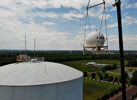
Life-saving one of a kind TV weather radar network                                                                                      4

radar has blind spots that create gaps               “We are known for our tornadoes,           Each weather radar scans a large,
in coverage mostly due to terrain. The               but we get it all, from hurricanes and     circular area, but because of the
WAAY 31 StormTracker Early Warning                   tropical storm remnants to blizzards       radar locations these circular areas
Radar Network changes that. With                     and ice storms,” McKenna says. “We         of coverage do not completely cover
radars covering all of North Alabama                 even get little earthquakes in northeast   regions, creating “safety gaps” in highly
from the Shoals to Huntsville and                    Alabama, possibly caused by the karst      populated areas such as Florence and
Decatur, to Guntersville, they have                  topography there.”                         Muscle Shoals in northwest Alabama.
eliminated any gaps in radar coverage,                                                          In addition, because beam height
providing live-real time data as severe              To help protect residents, WAAY-TV         increases with distance, a condition
weather approaches.                                  needed real-time radar insights. It also   accentuated by the earth’s curvature,
                                                     needed more extensive coverage than        the NWS radar beams couldn’t detect
Although the Hackleburg–Phil Campbell                the NWS could offer. The NWS uses two      atmospheric activity nearer to the
tornado was singularly devasting, North              long-range radar systems to gather data    ground on their outer edges.
Alabama residents are accustomed                     for North Alabama, a 13,500-square-
to tornado warnings. The region is                   mile region with large plateaus, rolling
prone to strong- to violent-category                 hills and some lowlands. One is located
tornadoes, particularly from March to                in Hytop, Alabama, northeast of
May. The state also experiences other                Huntsville in Jackson County, and the
types of severe weather year round.                  other is to the southwest in Columbus,
                                                     Mississippi, close to the state line.
Life-saving one of a kind TV weather radar network 5 Street-by-street weather data To address these limitations, the station built the WAAY 31 Storm Tracker Early Warning Radar Network, one of the largest privately owned radar networks in the US. Combining the station’s proprietary radar data with NWS data, WAAY-TV eliminates gaps in coverage and gains accurate, up-to-date weather information across North Alabama and into Mississippi, Tennessee and Georgia. The network comprises three Doppler radars from IBM Business Partner Enterprise Electronics Corporation (EEC), a leading global manufacturer of precision weather radars. The
Life-saving one of a kind TV weather radar network                                                                                        6

network radar data also integrates                   concluded that if the station installed a   The radar units complete 360-degree
seamlessly with Max Storm and other                  single, centrally located radar, coverage   scans every 60 seconds, delivering
Max Ecosystem solutions from The                     would be obstructed in some areas by        timely insights that meteorologists
Weather Company®, an IBM Business.                   the terrain. In the end, they decided to    need to accurately gauge developing
                                                     use three strategically located compact     weather situations. Meteorologists can
Rain or shine, WAAY-TV meteorologists                radars with overlapping coverage.           also run sector scans in seconds for
can now provide viewers with unique                                                              closeup views of specific areas.
weather insights, including exclusive                The station worked with EEC to hoist
alerts well in advance of approaching                a short-range EEC Ranger X-Band             Furthermore, EEC’s advanced, dual-
storms. By delivering forecasts on-air               unit atop a bank roof in Decatur.           polarity technology delivers 16-meter-
and also pushing them out to mobile                  They also installed two longer-range        resolution images, approximately
and web devices, they can not only                   EEC Maverick X-Band units on water          10 times that of NWS images. With
potentially save lives but also attract              towers—something never done before—         more detailed, overlapping coverage,
new viewers, including people who tend               in Muscle Shoals to the west and            meteorologists can view lower-level
to rely on third-party weather apps.                 another in Guntersville to the east.        circulations, such as smaller-scale
                                                                                                 tornadoes, microbursts and straight-
WAAY-TV meteorologists and EEC                       “From the business side of it, their        line winds.
engineers designed the WAAY 31                       service has been outstanding and
Storm Tracker Early Warning Radar                    incredibly responsive to our needs,”        EEC and specialists from The Weather
Network based on months of studying                  says Mike Wright, General Manager at        Company helped integrate the radar
historical tornado tracks and mapping                WAAY-TV, of EEC’s involvement in            network within the Max Storm solution,
radar beams. After their research, they              the project.                                which enables meteorologists to
Life-saving one of a kind TV weather radar network 7
create unique high-resolution radar
visualizations that are of higher “ The proof is in the data.
[During a recent winter
resolution than those created with
NWS radar data alone. In addition,
meteorologists can zoom in on areas of
possible heavy flash floods, rainfall and
hail. Most important, meteorologists
storm] our Decatur radar
can focus in on velocity information
indicating rotating storms, thereby
was scanning at such a
defining specific tornado locations and
movement down to the street level.
low level, we were able to
They can also diagram projected storm
trajectories in detail. see localized, lake-effect
Furthermore, meteorologists can snow. It was so localized
that the NWS radar in
rapidly distribute weather radar and
imagery across platforms using the Max
Engage with Watson® solution. With the
Max Connect solution, they can easily
control all these functions on- or off-air
Hytop and Columbus
using an Apple iPad device.
missed it.”
Kate McKenna, Chief Meteorologist, WAAY-TVLife-saving one of a kind TV weather radar network 8 Up to 4 – 6 times faster weather insights With the WAAY 31 Storm Tracker Early Warning Radar Network, the station gathers resolute weather insights every minute versus waiting up to 4 – 6 minutes for less precise NWS radar data, depending on the NWS scan mode in use. This time savings can literally make a life-or-death difference for residents. For Wright, nothing is more important than informing viewers of potentially life-threatening weather faster and with greater accuracy than anyone else. “Staying in front of the weather, to help keep people and their families safe, is
Life-saving one of a kind TV weather radar network                                                                                      9

one of our station’s highest callings,”              By investing in its own local radar       and talk one-on-one with WAAY-TV
he says.                                             network, the station is well positioned   meteorologists on social media.
                                                     to grow its audience and boost
The performance of WAAY-TV radar                     ratings, especially by expanding its      With a leading-edge radar network, the
as compared with NWS radar became                    digital presence.                         station has also strengthened its brand
apparent in mid-February 2021, when                                                            and culture. Employees and residents
a nearly nationwide storm caused                     “I want to be sure that when people       alike are taking ownership in the
freezing rain, sleet and snow across                 invest their time in WAAY, we give them   network, spurring deeper connections
Central and North Alabama.                           severe weather information they’re        that encourage viewers to keep tuning
                                                     looking for as quickly as we can and      in to WAAY-TV. For instance, the leaders
“The proof is in the data. Our Decatur               that it’s up-to-date—providing an         of Tuscumbia, Alabama, will present
radar was scanning at such a low level,              earlier warning than other radars         the station with a Key to the City award
we were able to see localized, lake-                 available in the market—and accurate,”    in gratitude for placing one of the radar
effect snow. It was so localized that the            comments Wright.                          units in nearby Muscle Shoals, an area
national radar in Hytop and Columbus                                                           previously unserved by radar coverage.
missed it,” explains McKenna.                        The station’s mobile and web views and
                                                     audience interactions have increased      “I’ve always believed you win with
“Also, we had flurries coming into the               since the network became fully            weather,” says Wright.
Shoals,” she adds, “and we were able                 operational in 2020. Using both mobile
to see those little bands of light snow,             and web devices, WAAY-TV viewers
which are notoriously difficult to pick              can access all three live radar screens
up. Nothing was visible on the                       at any time. They can also receive
national radars.”                                    timely, personalized weather insights
Life-saving one of a kind TV weather radar network 10
About WAAY-TV About Enterprise Electronics Corporation (EEC)
WAAY-TV, (external link) virtual channel 31, is an ABC-affiliated A global leader in weather radar and satellite systems, IBM
television station in Huntsville, Alabama, also home to NASA’s George Business Partner EEC (external link) has manufactured and installed
C. Marshall Space Flight Center. Owned by Allen Media Broadcasting, approximately 1,100 remote sensing systems in more than 100
WAAY-TV is a leading provider of local news, weather information, countries. Founded in 1971 in Enterprise, Alabama, the company
sports and community events. It has served the North Alabama and is an industry leader in introducing new technologies that enhance
Southern Tennessee region since 1959 and employees 74 people. performance. Its focus on technological innovation continues to help
drive its success.
Solution components
About The Weather Company
• Weather Company Max Connect
• Weather Company Max Engage with Watson® The Weather Company, an IBM Business, delivers more than 25
• Weather Company Max Storm billion personalized and actionable forecasts globally each day to
millions of consumers and thousands of marketers and businesses. It
accomplishes this through The Weather Company’s API, its business
solutions division, and digital products from The Weather Channel
(external link) and Weather Underground (external link). Its products
include the world’s most downloaded weather app, a network of
250,000 personal weather stations, a top-20 US website, one of the
world’s largest Internet of Things (IoT) data platforms, and industry-
leading business solutions.
© Copyright IBM Corporation 2021. IBM Corporation, The Weather Company, New Orchard Road, Armonk, NY 10504
Produced in the United States of America, April 2021.
IBM, the IBM logo, ibm.com, and With Watson are trademarks of International Business Machines Corp., registered in many jurisdictions worldwide. Other product and service names might be trademarks of IBM or
other companies. A current list of IBM trademarks is available on the web at “Copyright and trademark information” at www.ibm.com/legal/copytrade.shtml.
The Weather Channel®, The Weather Company®, and Weather Underground® are trademarks or registered trademarks of TWC Product and Technology, LLC, an IBM Company.
This document is current as of the initial date of publication and may be changed by IBM at any time. IBM Business Partners set their own prices, which may vary. Not all offerings are available in every country in which
IBM operates.
The performance data and client examples cited are presented for illustrative purposes only. Actual performance results may vary depending on specific configurations and operating conditions. It is the user’s
responsibility to evaluate and verify the operation of any other products or programs with IBM products and programs. THE INFORMATION IN THIS DOCUMENT IS PROVIDED “AS IS” WITHOUT ANY WARRANTY,
EXPRESS OR IMPLIED, INCLUDING WITHOUT ANY WARRANTIES OF MERCHANTABILITY, FITNESS FOR A PARTICULAR PURPOSE AND ANY WARRANTY OR CONDITION OF NON-INFRINGEMENT. IBM products are
warranted according to the terms and conditions of the agreements under which they are provided.
68038368USEN-01You can also read