ULULAH LAGOONS WATERBODY MANAGEMENT PLAN - DesignFlow Prepared for Fraser Coast Regional Council
←
→
Page content transcription
If your browser does not render page correctly, please read the page content below
ULULAH LAGOONS WATERBODY MANAGEMENT PLAN

DesignFlow
Prepared for Fraser Coast Regional Council
February 2021
Document Control Sheet

   Report Title:                  Ululah Lagoons Waterbody Management Plan V5

   Suggested Reference            Ululah Lagoons Waterbody Management Plan V5 (DesignFlow, February 2021)

   Version:                       FINAL

   Previous versions              CONSULTATION DRAFT - 15/11/2019

   Client:                        Fraser Coast Regional Council

   Author(s):                     Jason Sonneman, Andrew Cook, Shaun Leinster

   Reviewed By:                   Shaun Leinster

   Approved By:                   Shaun Leinster

   Date:                          26/02/2021

   File Location:                 S:\Projects\4409

   Circulation:                   Electronic Copies: Fraser Coast Regional Council

                                  Printed Copies: Nil

Disclaimer
This document has been prepared solely for the benefit of the client identified above, and is issued for the purposes only fo r which it is supplied.
Unauthorised use of this document in any form whatsoever is prohibited. This document shall not be reproduc ed or modified without written
permission from the document authors. No liability is accepted by DesignFlow Consulting Pty Ltd, or any employee, contractor or sub-consultant
of this company with respect to its use by any other person.

This disclaimer shall apply not withstanding that the document may be made available to other persons for information purposes, or for an
application for permission or approval to fulfil a legal obligation.
Table of Contents

SUMMARY ........................................................................................................................ 1
1 INTRODUCTION .......................................................................................................... 1
    1.1      INTRODUCTION ........................................................................................................................ 1
    1.2      APPROACH ............................................................................................................................... 1
    1.3      REPORT STRUCTURE ................................................................................................................. 2
2     WATERBODY INFORMATION AND HISTORY ................................................................. 3
    2.1      BACKGROUND .......................................................................................................................... 3
    2.2      EXISTING CATCHMENTS ........................................................................................................... 4
    2.3      EXISTING DRAINAGE ................................................................................................................. 5
    2.4      WATERBODY BATHYMETRY ...................................................................................................... 7
    2.5      INFORMAL STAKEHOLDER FEEDBACK ....................................................................................... 7
3     FIELD ASSESSMENT .................................................................................................... 8
4     ISSUES IDENTIFICATION AND PRIORITISATION ........................................................... 12
    4.1      IDENTIFY ISSUES ..................................................................................................................... 12
                PUBLIC SAFETY (BATTER SLOPES) ..................................................................................... 12
                WATERBODY EDGE STABILITY .......................................................................................... 15
                WATER QUALITY............................................................................................................... 15
                WATERBIRDS (FAECAL CONTAMINATION) ........................................................................ 17
                AQUATIC PLANT MANAGEMENT ...................................................................................... 19
                AQUATIC VEGETATION ..................................................................................................... 20
                HYDRAULIC RETENTION TIMES AND MIXING .................................................................... 21
    4.2      PRIORITISE ISSUES .................................................................................................................. 22
5     IDENTIFY MANAGEMENT ACTIONS ............................................................................ 25
    5.1      IDENTIFYING MANAGEMENT ACTIONS ................................................................................... 25
                PUBLIC SAFETY (BATTER SLOPES) ..................................................................................... 25
                WATER QUALITY............................................................................................................... 25
                WATERBIRD MANAGEMENT (FAECAL CONTAMINATION) ................................................. 26
                AQUATIC WEED MANAGEMENT ....................................................................................... 27
                AQUATIC VEGETATION ..................................................................................................... 29
                HYDRAULIC RETENTION TIMES AND MIXING .................................................................... 30
                LONG TERM OPPORTUNITIES ........................................................................................... 30
                EXCLUDED ACTIONS ......................................................................................................... 31
                DISCUSSION OF DREDGING / DEEPENING ......................................................................... 31
    5.2      MANAGEMENT PRIORITY ....................................................................................................... 32
    5.3      COMMUNITY CONSULTATION ................................................................................................ 32
6     MANAGEMENT PLAN................................................................................................ 35
    6.1      WATERBODY CHARACTERISTICS, ISSUES AND CONSTRAINTS ................................................. 35
    6.2      WATERBODY ISSUES AND MANAGEMENT ACTIONS ............................................................... 37
7 REFERENCES............................................................................................................. 44
APPENDIX A. WATERBODY FIELD CONDITION ASSESSMENT FORM .................................. 45
APPENDIX B. ULULAH LAGOONS ACTIONS TABLE ........................................................... 46
APPENDIX C. WMS FRAMEWORK: ISSUES AND MANAGEMENT TABLE ............................. 49

Ululah Lagoons Waterbody Management Plan                                                                                                             i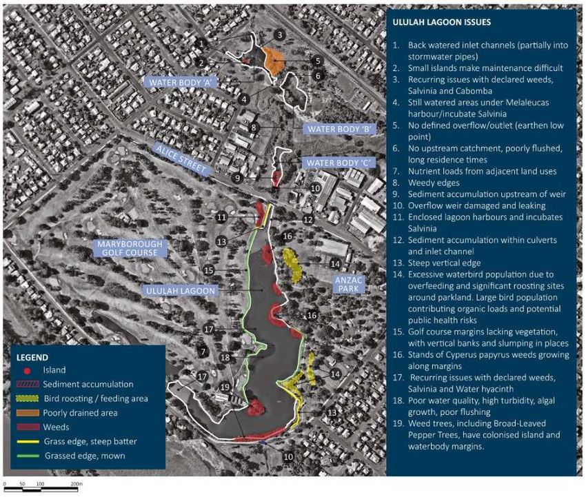
List of Tables
Table 2-1 Sub-catchments draining into the Ululah Lagoons system. ......................................................... 5
Table 3-1 Waterbodies A-C - Field condition assessment summary. .......................................................... 8
Table 3-2 Ululah Lagoons - Field condition assessment summary. ............................................................. 8
Table 4-1 Waterbody edge profiles within Ululah Lagoon. ....................................................................... 14
Table 5-1 Excluded management actions. ................................................................................................. 31
Table 6-1 Key characteristics of the Ululah Lagoons system. ................................................................... 35
Table 6-2 Issues and management actions for Ululah Lagoons system. ................................................... 37

List of Figures
Figure 1-1. Ululah Lagoons view from Anzac Park. ...................................................................................... 1
Figure 1-2. Overview of the waterbody management framework. .............................................................. 2
Figure 2-1 Historical photo of Ululah Lagoons in 1916 showing dense growth of water lilies (sourced from
www.pinterest.com.au). ............................................................................................................................. 4
Figure 2-2. Aerial image from 1959 showing Ululah Lagoon. Waterbodies north of Alice are not yet
constructed. ............................................................................................................................................... 4
Figure 2-3. Ululah Lagoons system layout and sub-catchment. .................................................................. 6
Figure 3-1 Waterbody A – a) Main waterbody, and b) Channel connecting Waterbodies A and B. ......... 10
Figure 3-2 Waterbody B – a) Main waterbody, and b) Overflow weir and outlet channel. ....................... 10
Figure 3-3 Waterbody C – a) Overflow weir, and b) Shallow waterbody upstream from the overflow weir.
 ................................................................................................................................................................. 10
Figure 3-4 Ululah Lagoons – a) Inlet channel below Alice St, and b) Enclosed lagoons within the golf course
adjacent to waterbody inlet. ..................................................................................................................... 11
Figure 3-5 Ululah Lagoons – a) Main waterbody, and b) Buffer zone along edge adjacent to Anzac Park.
 ................................................................................................................................................................. 11
Figure 4-1 Concrete revetment in the SE corner of Ululah Lagoon: a) Main section, and b) Collapsed section
towards the northern end. ....................................................................................................................... 13
Figure 4-2 Minor scour present below grassed edges creating shallow vertical edge. ............................. 15
Figure 4-3 Localised edge erosion occurring adjacent to the golf course near the inlet to Ululah Lagoon.15
Figure 4-4 Alternative states model used to interpret shallow waterbody function. ............................... 17
Figure 4-5 Bird feeding within Anzac Park, particularly around public seating areas, represent a potential
public health risk. ..................................................................................................................................... 18
Figure 4-6 Information sign on Alice St promoting the feeding of waterbirds within Anzac Park. ............. 18
Figure 4-7 Ibis rookery present on the island adjacent to the Golf Clubhouse. ......................................... 19
Figure 4-8 Historical aerial imagery indicating Salvinia blooms present within Ululah Lagoons in: a) 2010,
and b) 2019............................................................................................................................................... 19
Figure 4-9 Examples of emergent waterplants growing on the edges of Ululah Lagoons system: a) Typha
sp. (foreground) Phragmites australis (background), and b) Cyperus papyrus. ......................................... 21
Figure 4-10 Backwater areas present within: a) Waterbody A, and b) Waterbody B ............................... 22
Figure 4-11 Backwater areas present within Ululah Lagoon: a) Enclosed lagoons within the golf course,
and b) Areas within and adjacent to the Papyrus stands (act as incubators for algae and floating
waterplants). ............................................................................................................................................ 22
Figure 4-12 Waterbody A-C Management issues. ..................................................................................... 23
Figure 4-13 Ululah Lagoons Management issues ...................................................................................... 24
Figure 5-1 Example of direct-education message approach. .................................................................... 27
Figure 5-2. Summary of potential actions from the community consultation process. ............................. 33
Figure 6-1 Waterbodies A-C Management Actions Plan ............................................................................ 42
Figure 6-2 Ululah Lagoons Management Actions Plan .............................................................................. 43

Ululah Lagoons Waterbody Management Plan                                                                                                                         ii

SUMMARY
The Ululah Lagoons system is a high profile and amenity series of waterbodies located within Maryborough.
The system comprises four interconnected waterbodies that receive stormwater runoff from a 228 ha
catchment comprising of residential, industrial and parkland/natural land uses. The waterbodies are valued
by the local community and provide a high level of recreational amenity. The waterbodies are surrounded by
open parkland and are largely accessible to the public. The largest and most prominent waterbody,
commonly referred to as Ululah Lagoon, is located between Anzac Park and the Maryborough Golf Club.
Priority management issues identified for the Ululah Lagoons system include:
Public safety Aquatic weeds
Water quality Edge stability
Aquatic vegetation Waterbody residence times
As outlined in DesignFlow (2021) the risk associated with the ‘business as usual’ management approach may
results in high reactive management costs and/or further decline in water quality due to untreated
catchment inputs and associated increase in algal and floating weed issues. A proactive approach has to be
adopted.
Recommended Actions: The key management actions that have been identified as part of the Ululah Lagoons
Waterbody Management Plan (this report) include:
Immediate actions: o Landscaping works in key locations to
o Development of Waterbody Edge - Public discourage bird feeding and loafing.
Safety Risk Assessment to reduce/remove o Other items identified in the Waterbird
high risk waterbody edges to manage public Management Plan.
safety risk. o Implement works recommended in the Weed
o Development of Waterbird Management Plan Management Plan (Phase 2).
to assist in reducing public health risk o Wetland planting to shallow waterbody edges.
associated with waterbird faecal o Management of non-declared weeds (e.g.
contamination. Nymphaea mexicana).
o Development of Weed Management Plan (in o Develop a catchment based stormwater
particular to target Broad Leaf Pepper Tree). management strategy.
Short term actions (1-2 years): o Capital works to reduce weed harbouring
o Implement works to 'high risk' unsafe edges. areas in Waterbody A and B.
o Signage and landscaping works in key Long term opportunities (5-10 years):
locations to discourage bird feeding. o Reduce ponding within the Waterbody C
o Implement works recommended in the Weed channel area.
Management Plan (Phase 1). o Removal Cyperus papyrus stands.
o Targeted removal of declared weeds around o Continue to implement catchment based
waterbody margins (including reoccurrences stormwater treatment initiatives.
of Salvinia molesta and Hygrophila costata). Future / Aspirational:
o Terrestrial buffer planting (all systems). o Capital works to retrofit constructed wetland
Medium term actions (3-5 years): and recirculation system within upper section
o Install water level control to Ululah Lagoons of Ululah Lagoon.
main outlet. o Convert Ululah Lagoons to a natural wetland
o Stabilise eroding edges (e.g. golf course systems (dewater).
margins).
Ululah Lagoons Waterbody Management Plan 1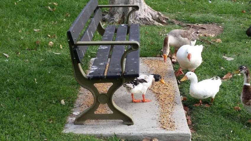
1 INTRODUCTION
1.1 INTRODUCTION
The Ululah Lagoons system is a series of high profile interconnected waterbodies located within
Maryborough. The waterbodies are surrounded by open parkland and residential areas, and are
accessible to the public. The largest and most prominent waterbody, commonly referred to as Ululah
Lagoon, is located between Anzac Park and the Maryborough Golf Club (Figure 1-1).
The Ululah Lagoons system receives stormwater runoff from a 228 ha catchment comprising of
residential, industrial and parkland/natural land uses. Catchment runoff flows through the series of
waterbodies and is discharged to the Mary River.
Poor water quality and long water residence times within the waterbodies results in the persistent
growth of aquatic weeds which require ongoing surveillance and intervention by Council.
This report presents the Ululah Lagoons Waterbody Management Plan (WMP). The Ululah Lagoons
system was identified to be a ‘Very High’ management priority system, as part of the Fraser Coast
Waterbody Management Strategy: Waterbody Management Framework Technical Report (DesignFlow,
2021). It was therefore selected as one of the initial waterbodies to have a specific plan developed to
inform its future management.
The Ululah Lagoons WMP will provide Council with a strategic path forward to manage and improve
the overall condition of the waterbodies.
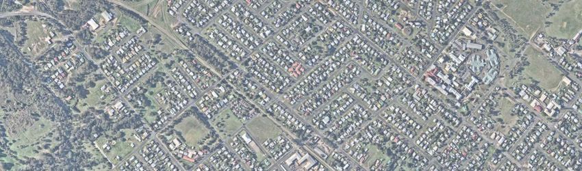
Figure 1-1. Ululah Lagoons view from Anzac Park.
1.2 APPROACH
The Ululah Lagoons WMP has been developed using the waterbody management framework outlined
in Fraser Coast Waterbody Management Strategy: Waterbody Management Framework Technical
Ululah Lagoons Waterbody Management Plan 1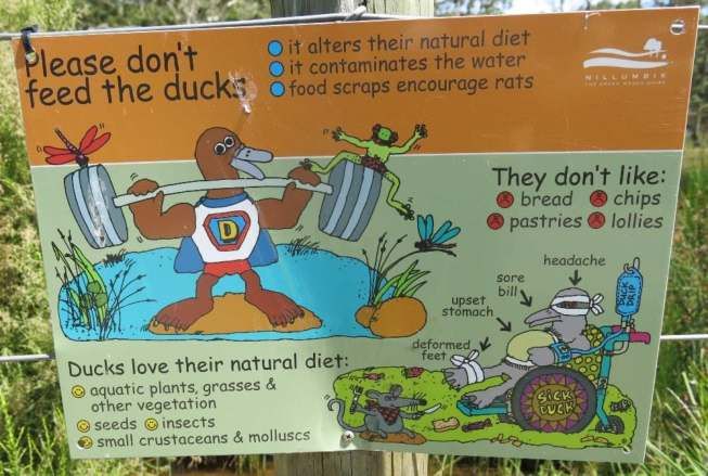
Report (DesignFlow, 2021). The framework involves a step-wise assessment and prioritisation approach
       to identify and manage FCRC waterbodies (Figure 1-2).

                        STEP 1: COLLATE WATERBODY INFORMATION AND HISTORY

Collate available information for the waterbody system, such as water quality and aquatic weed issues, catchment,
            survey and geotechnical data, previous maintenance works and supporting reports or plans.

                                         STEP 2: FIELD ASSESSMENT

                Undertake a field assessment and completed a Waterbody Condition Assessment.

                                  STEP 3: IDENTIFY AND PRIORITISE ISSUES

 Identify key issues and priorities based on outcomes of the Field Assessment and understanding of the waterbody
                                                      history.

                            STEP 4: IDENTIFY ACTIONS, TIMEFRAMES AND COSTS

                        Identify appropriate management actions, timeframes and costs.

                            STEP 5: PREPARE WATERBODY MANAGEMENT PLAN

Prepare a waterbody management plan that documents waterbody history, condition, priority issues and the agreed
                                  management / rehabilitation outcomes.

       Figure 1-2. Overview of the waterbody management framework.

1.3    REPORT STRUCTURE

       Sections 2-5 of this report provide details associated with each ‘step’ taken through the framework.
       Section 6 summarises the management plan for the Ululah Lagoons system based on the outcomes of
       these steps.

       Ululah Lagoons Waterbody Management Plan                                                        2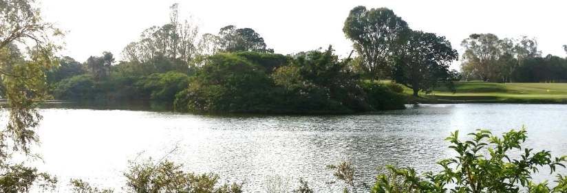
2 WATERBODY INFORMATION AND HISTORY
Waterbody information and history was collated via discussions with Council officers, correspondence
and a review of existing reports.
The following information relevant to the management plan was collated:
GIS information for the waterbody and catchment;
Topographical survey including pipes, pits, pathways, services and vegetation; and
Aquatic weed management approach.
2.1 BACKGROUND
Ululah Lagoons was originally a natural wetland system that was utilised by the local indigenous people.
In the 19th century, European settlers to the Maryborough area constructed a large weir across the
southern end of the wetland, thereby forming the large waterbody that exists today ( Figure 2-1 and
Figure 2-2). It is understood that the waterbody was initially used for water supply and recreational
activities, however in more recent times, it has become a high profile regional waterbody, associated
with passive recreation, tourism, and wetland habitat for a diverse range of native wildlife. The three
smaller waterbodies upstream of the main Ululah Lagoon were not constructed until approximately
1990-1993.
The Ululah Lagoons waterbodies have a long history of water quality and aquatic weed problems.
Occasional aquatic weed control and harvesting is undertaken to manage declared aquatic weeds,
particularly Salvinia molesta and Hygrophila costata. Cabomba caroliniana is also present within the
Ululah Lagoons system but is not subject to active control. Historic newspaper articles also indicate that
Ululah Lagoons has experienced outbreaks of Water hyacinth, and numerous fish kills have occurred in
response to poor water quality following flooding events.
The Maryborough community expects Council to provide a high level of service for the Ululah Lagoons
system, with a keen desire for a high amenity waterbody associated with both Anzac Park and the
Maryborough Golf Club.
Management of the waterbody to date has been largely reactive, focusing primarily on the
maintenance of the waterbody edges and aquatic weed removal to preserve the amenity of the
waterbodies. A large volume of accumulated sediment (approximately 1000 m3) was also recently
removed from the inlet area of Ululah Lagoon for drainage purposes.
Ululah Lagoons Waterbody Management Plan 3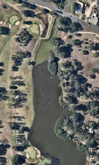
Figure 2-1 Historical photo of Ululah Lagoons in 1916 showing dense growth of water lilies (sourced
      from www.pinterest.com.au).

      Figure 2-2. Aerial image from 1959 showing Ululah Lagoon. Waterbodies north of Alice are not yet
      constructed.

2.2   EXISTING CATCHMENTS

      The Ululah Lagoons system comprises of four interconnected waterbodies (Figure 2-3). For the purpose
      of this WMP, the waterbodies have been identified as Waterbodies A to C, and Ululah Lagoon (main
      waterbody).

      The Ululah Lagoons catchment area is approximately 228 ha and comprises of residential, parkland and
      industrial areas. Stormwater runoff from the surrounding sub-catchments enters the waterbody system

      Ululah Lagoons Waterbody Management Plan                                                     4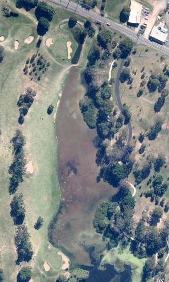
via stormwater inlets to Waterbodies A, C and Ululah Lagoon. Waterbody B only receives runoff from
      the adjacent parkland and inflows from Waterbody A. A summary of the sub-catchments areas is
      presented in Table 2-1.

      Table 2-1 Sub-catchments draining into the Ululah Lagoons system.

       Waterbody                   Sub-catchments                      Sub-catchment area (ha)
       Waterbody A                         2                                     73.1
       Waterbody B                         0                                       0
       Waterbody C                         1                                      91
       Ululah Lagoon                       4                                     64.5

2.3   EXISTING DRAINAGE

      Stormwater runoff enters Waterbody A via two inlets and flows towards Waterbody B. The connection
      between Waterbodies A and B is not well defined. An outlet channel runs between the two
      waterbodies, however the downstream end of the channel terminates in an earthen bund prior to
      Waterbody B. Water flowing into Waterbody A appears to backwater into an adjacent patch of
      Melaleuca, and it is likely that the water enters Waterbody B via informal channels within the
      Melaleucas (Figure 2-3). It is likely that flows from Waterbody A overtop the earthen bund and flow
      into Waterbody B during moderate rainfall events.

      Overflows from Waterbody B are discharged into a drainage channel that meanders through EB Uhr
      Park and discharges into Waterbody C (Figure 2-3). Stormwater runoff from a large catchment enters
      Waterbody C from the east. Overflows from Waterbody C discharge over a concrete weir and enter the
      top of Ululah Lagoon.

      Stormwater runoff enters Ululah Lagoon from sub-catchments adjacent to Alice St, Maryborough Golf
      Club, Anzac Park and a residential area to the east of Anzac Park. The water flows in a southerly
      direction through Ululah Lagoon and discharges from the waterbody via a circular (gloryhole) overflow
      weir. The water flows along a shallow drainage line and discharges into the Mary River.

      The Ululah Lagoons system does not provide formal flood retention, however it is likely that restrictions
      associated with the Alice St Bridge and the Ululah Lagoons overflow function to partially retard large
      flood events.

      Ululah Lagoons Waterbody Management Plan                                                          5
LEGEND
Lake
Property boundary
Catchment boundary
Existing stormwater pipe
45.4 ha
27.7 ha
Waterbody A
Waterbody B
91.0 ha
7.5 ha
Waterbody C
12.8 ha
0
000
0 75
75
75
75
75 150
150
150
150
150 300
300 m
300 m
m
Ululah Lagoon
14.7 ha Figure 2-1. Ululah Lagoon - System
layout and sub-catchments
29.5 ha Ululah Lagoons Waterbody
Management Plan
SCALE:
1:7,500
DATE:
19 February 2021
DesignFlow
PO Box 1250, Southport BC
7 Bauer St, Southport QLD 4215
For:
FCRC2.4 WATERBODY BATHYMETRY
There is currently no bathymetric survey data available for the Ululah Lagoons system. Waterbodies A-
C are shallow waterbodies, generally less than 1m depth. It is understood that the majority of Ululah
Lagoon is shallow (generally less than 1m) grading to deeper sections (up to 5m depth) adjacent to the
outlet.
Historical imagery indicates that the water levels within each of the waterbodies appears relatively
stable, with minor fluctuations occurring in response to seasonal rainfall patterns. However, it is
understood that the water level within Ululah Lagoons seasonally fluctuates, with the shallow
submerged edges of the waterbody being exposed during extended dry periods.
2.5 INFORMAL STAKEHOLDER FEEDBACK
The following issues were identified through discussion with relevant Council officers and onsite
maintenance staff having knowledge of the local system and exposure of previous community feedback
and requests:
Council is expected to provide a higher level of service for Ululah Lagoon, which is integral to
both Anzac Park and the Golf Club, and a major tourist destination within the Maryborough
region.
The growth of aquatic plants, particularly the declared floating species, Salvinia molesta, is an
ongoing management issue for Council.
Access for Council’s weed harvester is not considered to be an issue, and all waterbodies are
readily accessible.
The upper end of Ululah Lagoon is subject to sediment accumulation and has been previously
dredged.
Fish kills have occurred several times within Ululah Lagoon, generally following flooding
events.
Requests for dredging generally follow the occurrence of fish kills, and the exposure of bank
edges during prolonged seasonal dry periods.
Dredging has generally not been supported to date due to being unviable (i.e. high cost) and
potentially detrimental to waterbody health, but is expected to be further informed by the
Fraser Coast Waterbody Management Strategy: Waterbody Management Framework
Technical Report (DesignFlow, 2021) and this Plan.
No water is permitted to be extracted from Ululah Lagoons for irrigation of Anzac Park or
surrounding areas, including the Golf Club.
The Golf Club maintains the waterbody edges adjacent to the golf course, however it is
understood that Council controls the Hygrophila costata growing along the golf course edge.
Council Officers expressed a desire to achieve a healthy and robust waterbody system through
the establishment and maintenance of native aquatic and riparian vegetation.
Ululah Lagoons Waterbody Management Plan 73 FIELD ASSESSMENT
A field assessment of the Ululah Lagoons system was conducted by DesignFlow on the 3rd December
2018 and 21st May 2019. A summary of the field assessment findings and scores for each waterbody
are provided in the Table 3-1 and Table 3-2. Photographs from the site inspections are provided in
Figure 3-1 through Figure 3-5.
Table 3-1 Waterbodies A-C - Field condition assessment summary.
Performance Indicator Rating Comments
Risk of injury or drowning 1 No public health & safety issues identified.
Public Health & Safety
Batter slopes 1
Fencing/barriers 1
Contaminated Water 1
Mosquitoes 1
Overall condition score 1
Overall condition rating Good
Inlet condition 2 Waterbody A inlet channels backwatered.
Outlet condition Waterbody A overtops bund into Waterbody B.
3
Weir below Waterbody C is damaged and leaking.
Hydraulic Function
Other structures - Long residence times in all three waterbodies during the dry season.
Flushing/Residence Time 4 Waterbody B is shallow and filled via overflows from Waterbody A.
Water Levels 2 Water level in Waterbody C lower than overflow weir due to leakage.
Stability of batters and bunds 1 Notable sediment accumulation present in Waterbody C.
Sediment accumulation 3
Overall condition score 2.5
Overall condition rating Poor
Odours 1 Water in Waterbody A and C turbid due to suspended solids.
Algae/Cyanobacteria
Water Quality
1
Turbidity 3
Litter/debris 1
Overall condition score 1.5
Overall condition rating Adequate
Aquatic vegetation - emergent 3 Isolated patches of emergent waterplants present along the margins of
Aquatic vegetation - submerged the waterbodies.
4
No native submerged waterplants present in the waterbodies.
Aquatic vegetation - floating 1
Aquatic habitat
No native floating waterplants present.
Aquatic weeds - declared 4 Declared weed Cabomba caroliniana (submerged waterplant) present
Aquatic weeds – non-declared 3 within Waterbodies A and B.
Aquatic fauna and pests Declared weed Salvinia molesta (floating waterplant) present within all
1
waterbodies.
Filamentous algae 1 Margins of waterbodies with notable cover of introduced grass species
Overall condition score 2.4 (Guinea grass),
Overall condition rating Adequate
Edge vegetation condition 2 Edges of waterbodies generally with dense vegetation cover comprising a
Terrestrial weeds – declared mix of native and introduced species.
Terrestrial
1
habitat
Declared Broad-leaved Pepper trees present in several locations.
Terrestrial weeds – non-declared 2 Waterbody edges dominated by introduced grasses (i.e. Para and Guinea
Overall condition score 1.7 grass) in several locations.
Overall condition rating Adequate Other weeds present include Cockspur Coral tree.
Access to waterbody reserve 1 Access to water surface in Waterbodies A and B via batters (i.e. no formal
Maintenance
Access to waterbody margin ramp).
2
Access
Limited access to water surface in Waterbody C.
Access to water surface 3
Overall condition score 2
Overall condition rating Adequate
Overall condition rating based on: Good 3.5.
Table 3-2 Ululah Lagoons - Field condition assessment summary.
Ululah Lagoons Waterbody Management Plan 8Performance Indicator Rating Comments
Risk of injury or drowning 3 Steep edges present adjacent to deep water areas.
Batter slopes 2 Steep batter slopes present including partially submerged concrete
Public Health &
Fencing/barriers 3 revetment which has collapsed at one end.
Safety
Contaminated Water 3 Rail fencing present on embankment near the waterbody outlet.
Mosquitoes 1 Fencing or passive barriers required adjacent to high risk areas.
Overall condition score 2.4 High algal biomass present in waterbody.
Overall condition rating Adequate Presence of large waterbird population likely to be contributing faecal
matter to the waterbody.
Inlet condition 3 Inlet channel to waterbody below the Alice St bridge appears to be an
Outlet condition 2 eroded channel.
Other structures - Waterway above the Alice St bridge incised up to weir below Waterway
Flushing/Residence Time 3 C.
Hydraulic Function
Water Levels 1 Submerged culverts under Alice St may be partially blocked with
Stability of batters and bunds 3 sediment.
Sediment accumulation 2 Waterbody outlet (glory hole weir) is leaking through the walls. Minor
Overall condition score 2.3 damage to weir crest.
Overall condition rating Adequate Waterbody residence times likely to be very high.
Several backwater areas present including enclosed lagoons near
waterbody inlet, waterbody edges and around Papyrus ‘islands’.
Minor erosion present around the waterbody edges, particularly along
Golf Course edges.
Accumulated sediment likely to be present throughout the waterbody.
Odours 1 Visible algal biomass present within the water column.
Water Quality
Algae/Cyanobacteria 3 Water column notably turbid due to combination of algal biomass and
Turbidity 3 suspended solids.
Litter/debris 1
Overall condition score 2
Overall condition rating Adequate
Aquatic vegetation - emergent 4 No native emergent or submerged water plants present within the
Aquatic vegetation - submerged 4 waterbody.
Aquatic vegetation - floating 1 Lemna sp. observed floating on the surface of the enclosed lagoons near
Aquatic habitat
Aquatic weeds - declared 2 waterbody inlet.
Aquatic weeds – non-declared 2 Declared water plant species – Salvinia molesta and Hygrophila costata
present within the waterbody. Cabomba caroliniana also likely to be
Aquatic fauna and pests 3
present but not observed due to high turbidity.
Filamentous algae 1
Large stands of Cyperus papyrus present adjacent to Anzac Park.
Overall condition score 2
Large permanent waterbird population present including: Ibis, Egrets,
Overall condition rating Adequate Cormorants, Darters, Spoonbills, native and introduced Ducks and Coots.
Edge vegetation condition 3 Riparian vegetation cover generally very poor around the waterbody
Terrestrial habitat
Terrestrial weeds – declared 3 margins.
Terrestrial weeds – non-declared 2 Batters dominated by grasses and weed species.
Overall condition score 2.7 Large trees with dense canopy present in some areas.
Overall condition rating Poor Broad-leaved Pepper trees present around the waterbody margins.
Other notable weed species present include Cockspur Coral tree.
Access to waterbody reserve 1 The majority of the Ululah Lagoons can be accessed via Anzac Park and
Maintenance
Access to waterbody margin 2 Maryborough Golf Club.
Access
Access to water surface 2 No formal access to the water surface present. Harvester access possible
Overall condition score 1.7 from most margins of the waterbody.
Overall condition rating Adequate
Overall condition rating based on: Good 3.5.
Ululah Lagoons Waterbody Management Plan 9Figure 3-1 Waterbody A – a) Main waterbody, and b) Channel connecting Waterbodies A and B.
Figure 3-2 Waterbody B – a) Main waterbody, and b) Overflow weir and outlet channel.
Figure 3-3 Waterbody C – a) Overflow weir, and b) Shallow waterbody upstream from the overflow
weir.
Ululah Lagoons Waterbody Management Plan 10Figure 3-4 Ululah Lagoons – a) Inlet channel below Alice St, and b) Enclosed lagoons within the golf
course adjacent to waterbody inlet.
Figure 3-5 Ululah Lagoons – a) Main waterbody, and b) Buffer zone along edge adjacent to Anzac
Park.
Ululah Lagoons Waterbody Management Plan 114 ISSUES IDENTIFICATION AND PRIORITISATION
Following the condition assessment, the range of waterbody management issues were identified and
prioritised.
Priority issues (high–medium) identified for the Ululah Lagoons system include:
Public safety
Water quality
Aquatic vegetation
Aquatic weeds
Waterbody edge stability
Waterbody residence times
4.1 IDENTIFY ISSUES
The following sub-sections provide a summary of the management issues associated the Ululah Lagoons
system.
Public safety (Batter slopes)
The majority of the batter slopes throughout the Ululah Lagoons system are generally less than 1V:3H,
and in most cases, the presence of shallow water adjacent to the waterbody edge renders the edges
relatively safe as there is low drowning risk.
Sections of the batter slopes along the eastern side of Ululah Lagoons (adjacent to Anzac Park) are
extremely steep, do not have a vegetated buffer zone and are considered to be a potential public safety
risk. In most areas, shallow water along the waterbody edge renders the risk low, however there are a
number of sections where the steep batters transition into deeper water and the potential risk is higher.
Some edges within Ululah Lagoon, comprise of sharp drop offs into deep water, and represent an
increased risk of drowning should someone accidentally enter the water. This includes the upper
section of Ululah Lagoons on either side Alice St where the waterbody is channelised.
Areas of Ululah Lagoons that have batter slopes steeper than 1:3 are considered a potential safety risk
due to:
The high risk of unintentional water entry
Exiting the water can be difficult due to the batter slope
The presence of drop offs/vertical edges at the base of the batter slope makes exiting more
difficult
The presence of deep water and steep batter slope increases drowning risk substantially
The edges in south-east corner of Ululah Lagoon comprise of concrete revetments which slope from
the mown grassed edge into the water to approximately 0.4-0.5 m depth (Figure 4-1). In several
locations, the concrete revetment has collapsed resulting in a steeper entry into the water (1:1-1:2 in
some locations). Where this has occurred, the revetment slope and presence of deep water would make
exiting the waterbody difficult.
Ululah Lagoons Waterbody Management Plan 12Figure 4-1 Concrete revetment in the SE corner of Ululah Lagoon: a) Main section, and b) Collapsed section towards the northern end. The edges of Ululah Lagoon adjacent to the golf course varies from gentle grassed slopes to sharp- vertical drop-offs. The majority of the golf course edges have been stabilised with rock beaching and a submerged bench is present in most areas. The deepest section of Ululah Lagoon is located adjacent to the overflow weir at the southern end of the waterbody. The batter slopes in this section of the waterbody are generally steeper than 1:4 slope, however the presence of dense buffer vegetation on the batters effectively prevents unintentional water access. A summary of the common batter slope/waterbody edge profiles and associated safety risks are presented in Table 4-1. Unsafe edges are mapped for Ululah Lagoon in Figure 4-13 (yellow edges). Ululah Lagoons Waterbody Management Plan 13
Table 4-1 Waterbody edge profiles within Ululah Lagoon.
 Edge Type                  Comments/notes                               Photo
 Gentle batter +/- sharp    Generally >1:3 batter slope, mown
 drop off into shallow      grassed edge +/- sharp drop off into
 water                      shallow (1:3 batter slope, mown
 drop off into deep water   grassed edge +/- sharp drop off into
                            deep (>0.3m) water. High risk as deep
                            depth of water means exiting may be
                            difficult.
                            Potentially Hazardous

 Steep batter +/- sharp     Generally
Waterbody edge stability
The majority of the waterbody edges/lower batters have good vegetation cover and are stable. The
edges of Waterbodies A-C are well vegetated with a mix of groundcovers (i.e. grasses), shrubs and trees,
and a minimum 1.5-2 m vegetated buffer zone is generally present in public accessible areas.
The majority of the publicly accessible edges in Ululah Lagoons (adjacent to Anzac Park), comprise of
either mown grass or a vegetated buffer. In most locations, wave action or waterbird activity has
resulted in minor scour and the development of shallow vertical edges (Figure 4-2). These edges are
relatively stable but are susceptible to further instability due the presence of the bare soils along the
exposed edges.
The waterbody edges adjacent to the golf course are grassed and vary in slope from a gentle batter
slope to the water’s edge to steep vertical drop-offs. The presence of rock protection below the water
surface in most cases renders the edges reasonably safe. There are several sections where localised
erosion of the waterbody edge has occurred resulting in slumping and the creation of vertical edges
Figure 4-3.
Figure 4-2 Minor scour present below grassed edges creating shallow vertical edge.
Figure 4-3 Localised edge erosion occurring adjacent to the golf course near the inlet to Ululah
Lagoon.
Water quality
No water quality data is readily available for Ululah Lagoons so the following section is based upon
observations made during the site inspections and discussions with Council staff.
Ululah Lagoons Waterbody Management Plan 15Nutrients: It is likely that high nutrient concentrations are present within each of the waterbodies based on the growth of floating waterplants (i.e. Salvinia) and the visible algal biomass within Ululah Lagoon. Catchment runoff is likely to comprise the primary source of nutrient loads into the Ululah Lagoons system. Both surface runoff and shallow groundwater discharge from the golf course is also likely to contribute significant nutrient loads into Ululah Lagoons. Inputs of faecal matter associated with the large waterbird population in Ululah Lagoons is also likely to contribute to the overall nutrient load. Algal biomass: Planktonic algal biomass was visible in Ululah Lagoons during the 2018 and 2019 waterbody condition assessments. The presence of algal biomass indicates that there are high nutrient concentrations present throughout the waterbody. Algal growth within urban waterbodies is stimulated by nutrients, water temperature and light. Healthy, robust, shallow waterbodies generally have high submerged and emergent waterplant cover. Waterplants, and in particular submerged species, aggressively compete with algae for nutrient resources, such as phosphorus, and help to maintain low turbidity in shallow waterbody systems. Waterbodies with high waterplant cover are generally able to withstand moderate increases in nutrient levels and turbidity, however, a threshold exists whereby the submerged waterplants are unable to access sufficient light resources to survive the plant population crashes. This may be due to excessive turbidity (i.e. via stormwater runoff) or the growth of floating waterplants (i.e. Azolla or Salvinia). The loss of submerged plants is rapid and catastrophic, and results in a transition from a clear water waterplant dominated state to either an algal or floating waterplant state. This is referred to as the ‘alternative states model’ and is a scientific model often used to interpret and understand shallow waterbody function (Figure 4-4). Catchment inputs: The Ululah Lagoons’ 228 ha contributing catchment includes low density residential and some industrial land uses. Stormwater runoff from these land uses areas will deliver pollutants into the waterbodies in the form of nutrients, sediments and other contaminants (i.e. associated with roads etc). These catchment inputs over time result in the accumulation of pollutants and deterioration of waterbody health. Ululah Lagoons Waterbody Management Plan 16
Figure 4-4 Alternative states model used to interpret shallow waterbody function.

            Waterbirds (Faecal contamination)

Ululah Lagoon is home to a diverse assemblage of waterbirds including: Ibis, Egrets, Cormorants,
Darters, Spoonbills, Black Swans, Pelicans, native and introduced Ducks, Purple Swamp Hens and Coots.

A potential public health risk is associated with contact with waterbird faecal matter present within the
water and edges of Ululah Lagoon, particularly adjacent to the roosting/rookery areas and bird feeding
areas.

Areas within the Anzac Park where waterbirds congregate (i.e. public feeding areas) are likely to
represent a higher health risk, as there is generally higher deposition of bird faeces in these areas.

Observations during the site inspections indicated that the waterbirds are being regularly fed
throughout the day within the park (Figure 4-5). Public feeding of the waterbirds in Anzac Park is
currently promoted by Council as indicated by the roadside signs located within Alice St ( Figure 4-6).

Ibis and Egret rookeries are present within Anzac Park and the island adjacent to the Golf Clubhouse
(Figure 4-7). The presence of the rookeries is related to tree habitat located adjacent to or overhanging
the water.

The size of the waterbird population in Ululah Lagoon appears to reflect the feeding regime occurring
within Anzac Park, and not necessarily the quantity and quality of habitat and food resources present
within the waterbody. The regular supply of food sustains higher numbers of birds than would naturally
be present within the waterbody system, and is potentially impacting waterbody health via bird faeces
and organic material (e.g. egg shells, feathers, food scraps etc.) entering the system.

Ululah Lagoons Waterbody Management Plan                                                            17
The presence of the large waterbird population within Ululah Lagoon potentially impacts upon:
Water quality – Bird faeces entering the waterbody is likely to contribute a significant nutrient
load and promote the growth of algae and floating water plants.
Public safety – The large volume of bird faeces present represents a potential public health
risk from direct exposure to excreta or indirect exposure to waters contaminated by faeces or
associated algal blooms.
Public amenity – Many of the grassed around the waterbodies are used by the birds for loafing
and are generally covered by excreta resulting in smell and reduced amenity.
Figure 4-5 Bird feeding within Anzac Park, particularly around public seating areas, represent a
potential public health risk.
Figure 4-6 Information sign on Alice St promoting the feeding of waterbirds within Anzac Park.
Ululah Lagoons Waterbody Management Plan 18Figure 4-7 Ibis rookery present on the island adjacent to the Golf Clubhouse.
Aquatic plant management
Declared weeds - A number of declared aquatic weeds were observed during the waterbody condition
audit including: Salvinia molesta, Cabomba caroliana and Hygrophila costata. A declared terrestrial
species, Broad-leaved Pepper tree, was also observed growing throughout the Ululah Lagoons system.
Discussion with Council staff and a review of historical aerial imagery indicates that growth of Salvinia
regularly occurs within all of the waterbodies, and is an ongoing management issue (Figure 4-8).
Figure 4-8 Historical aerial imagery indicating Salvinia blooms present within Ululah Lagoons in: a)
2010, and b) 2019.
Salvinia is mechanically removed from Waterbody A using Council’s aquatic weed harvester, however
Salvinia growth in Waterbodies B and C is sprayed with herbicide due to the shallow water depths
present. Salvinia is also sprayed in Ululah Lagoons due to issues operating the Council harvester in
shallow depths near the waterbody inlet. A floating boom is also placed across the centre of Ululah
Lagoons to isolate the floating plants to one end of the waterbody.
Ululah Lagoons Waterbody Management Plan 19It is likely that the growth of Salvinia with the Ululah Lagoons waterbodies is stimulated by both
nutrients and water temperature. Backwater areas present throughout the waterbodies harbour
Salvinia in between growth events, thereby providing an ongoing source of vegetative material.
Backwater areas present include:
Melaleuca swamp between Waterbodies A and B
Waterbody C
Inlet channel areas to Ululah Lagoons (upstream and downstream of Alice St)
Enclosed lagoons in the golf course (adjacent to the Ululah Lagoons inlet area)
Areas associated with the C. papyrus stands within Ululah Lagoon
Backwater/inlet areas within Ululah Lagoon
It is understood that Hygrophila growth around the margins of Ululah Lagoons is chemically controlled.
There is currently no active control of Cabomba or Broad-leaved Pepper tree being implemented within
the Ululah Lagoons system.
Aquatic vegetation
Waterplant communities within the Ululah Lagoons system comprise of isolated patches of emergent
waterplants along the waterbody edges (mainly Phragmites australis and Typha sp.), and widespread
cover of submerged waterplant, Cabomba caroliniana (declared weed), within Waterbodies A and B.
No submerged waterplants were observed in Waterbody C or Ululah Lagoon, although it highly likely
that Cabomba is also growing in both. No native emergent waterplant species were observed in Ululah
Lagoon, although there are several large patches of Cyperus papyrus (introduced) present adjacent to
Anzac Park, and widespread growth of Hygrophila costata (declared weed) along the golf course
waterbody edge.
The presence of dense waterplant communities, particularly submerged waterplants, provides
competition for bio-available nutrients and assists with the removal of suspended solids. It can be seen
in the conceptual model outlined in Figure 4-4 that the absence of waterplants leads to a turbid
waterbody dominated by either floating waterplants or algae. In the case of Ululah Lagoon, the
waterbody has transitioned to a state dominated by floating waterplants (i.e. Salvinia) and algae, where
the presence of turbid water and deep submerged edges prevents waterplants from re -establishing
within the waterbody.
Emergent waterplants are also important as the biofilms growing on the plant stems and the plants
themselves aggressively compete for nutrients within the water column. Emergent water plants are
also important for stabilising the waterbody edges, preventing erosion and the introduction of
suspended solids to the waterbodies.
The distribution of emergent waterplants throughout the Ululah Lagoons system is extremely patchy.
The reasons for sparse emergent waterplant cover are not clear but may be due to:
waterbird grazing
active erosion
root disturbance by fish
lack of waterplant recruitment
steep to vertical batters
deep water at the waterbody edges
herbicide overspray (when treating Salvinia outbreaks)
Ululah Lagoons Waterbody Management Plan 20Figure 4-9 Examples of emergent waterplants growing on the edges of Ululah Lagoons system: a)
Typha sp. (foreground) Phragmites australis (background), and b) Cyperus papyrus.
Hydraulic retention times and mixing
The Ululah Lagoons system is characterised by high residence times and areas with poor flushing. The
waterbody residence times are dependent upon seasonal rainfall patterns. Residence times are shorter
during the wet season when stormwater inflows flush the waterbodies, and longer during the dry
season due to the lack of inflows.
Long residence times during the dry season combined with areas of the waterbodies with moderate
depth (i.e. >2m) is likely to facilitate the development of stratified conditions. Stratification of the water
column is important to understand as it can lead to the development of an anoxic hypolimnion (bottom
layer of water) and the subsequent release of nutrients from the waterbody sediments. The release of
nutrients due to stratification is often associated with the development of algal biomass and the
excessive growth of aquatic weeds (Figure 4-4).
Long residence times combined with warmer water temperatures, such as the start and end of the dry
season, can also stimulate the breakdown of organic material within the base of the waterbodies,
resulting in similar conditions to stratification. This can also lead to the release of nutrients into the
water column. The presence of stratified conditions followed by mixing of the waterbody can also lead
to fish kills due to low oxygen concentrations within the water column.
Backwater areas within the waterbodies often have longer residence times as they are poorly flushed.
Backwater areas often appear stagnant and are associated with the accumulation and decomposition
of organic material. Poorly flushed areas combined with nutrient release from the sediments often
results in ideal conditions for incubating algae and floating water weeds. This clearly occurs within the
Ululah Lagoons system, particularly in Waterbodies A and B, where stagnant backwater areas provide
ideal conditions for Salvinia incubation and growth. Several backwater areas are also present in Ululah
Lagoons where Salvinia growth can occur. This includes the enclosed lagoons within the golf course
adjacent to the waterbody inlet, inlet channel areas upstream and downstream of Alice St, and areas
associated with the large stands of Papyrus within Ululah Lagoons (Figure 4-11).
Ululah Lagoons Waterbody Management Plan 21Figure 4-10 Backwater areas present within: a) Waterbody A, and b) Waterbody B
Figure 4-11 Backwater areas present within Ululah Lagoon: a) Enclosed lagoons within the golf
course, and b) Areas within and adjacent to the Papyrus stands (act as incubators for algae and
floating waterplants).
4.2 PRIORITISE ISSUES
The waterbody management issues identified above have been mapped and prioritised for each
waterbody (refer Figure 4-12 and Figure 4-13). Issues have been prioritised based on the rating system
developed in the Fraser Coast Waterbody Management Strategy: Waterbody Management Framework
Technical Report (DesignFlow, 2021). Each waterbody issue has been prioritised as either:
High – Issue is currently management risk to Council, health and safety or environment that
requires addressing.
Medium - Issue is a minor management risk to Council, health and safety or environment but
has the potential to become a High priority in future if not managed.
Low – Not currently a management risk to Council and unlikely to become issue in near future.
Ululah Lagoons Waterbody Management Plan 22LEGEND
B3 Back watered inlet channels Property boundary
Existing stormwater pipe
Waterbody A 1m contours
Edges difficult to access for Grassed edge, steep batter,
F1
maintenance sharp drop-off
Grassed edge, mown
Back-watered areas under Melaleuca's
D1/B3
D2 Salvinia and Cabomba growth harbour/incubate Salvinia Vegetated buffer (unmown)
Overhanging vegetation
(native & introduced)
Edge dominated by over
D2 Salvinia and Cabomba growth
hanging Broadleaf Pepper Tree
B2 No defined overflow/outlet High priority issue
Waterbody B
No upstream catchment, poorly Medium priority issue
B3
flushed, long residence times
E1/E2 Weedy edges
0
000
0 20
20
20
20
20 40
40
40
40
40 80
80
80 m
80 m
m
Issue Key (Appendix B):
A1 Risk of injury or drowning
A2 Health risks due to human contact with
Waterbody C
Figure 4-12.
contaminated water
A3 Chemical contamination. Waterbody A to C issues plan
A4 Faecal and/or nutrient contamination. B7 Sediment accumulation
A5 Human health risk due to excessive Mosquito
Populations
B1 Inlet/outlet erosion or instability Overflow weir damaged and Ululah Lagoon Waterbody
B1
B2 Outlet blockage - Water level is consistently too leaking Management Plan
high above normal water level
B3 Poor flushing or dead pockets
B4 Water level is consistently too low
B5 Flooding of adjacent land, parkland or property or
regular over-topping of waterbody bund
B6 Scour of batters
B7 Coarse sediment accumulation
B8 Fine sediment or organic matter accumulation
C1 Odours
SCALE:
1:2,000
DATE:
18 February 2021
C2 Algal or cyanobacterial blooms DesignFlow
C3 Persistent high turbidity levels. PO Box 1250, Southport BC
C4 Stratification and low dissolved oxygen
C5 Variable salinity
7 Bauer St, Southport QLD 4215
C6 Litter
D1 Aquatic weeds
D2 Presence of aquatic pests (e.g. exotic fish For:
species) FCRC
E1 Terrestrial weeds Ululah Lagoon
F1 Access for maintenanceIssue Key (Appendix B):
Waterbody C A1 Risk of injury or drowning
A2 Health risks due to human contact with
contaminated water
A3 Chemical contamination.
Partial blockage of submerged A4 Faecal and/or nutrient contamination.
B1
inlets A5 Human health risk due to excessive Mosquito
Populations
B1 Inlet/outlet erosion or instability
B1 Eroding inlet channel B2 Outlet blockage - Water level is consistently too
high above normal water level
B3 Poor flushing or dead pockets LEGEND
Enclosed lagoon harbours and B4 Water level is consistently too low
D1/B3 B5 Flooding of adjacent land, parkland or property or
incubates Salvinia A1 Vertical edge
regular over-topping of waterbody bund Property boundary
B6 Scour of batters
B7 Coarse sediment accumulation
B8 Fine sediment or organic matter accumulation Existing stormwater pipe
C1 Odours
C2 Algal or cyanobacterial blooms
C3 Persistent high turbidity levels.
1m contours
C4 Stratification and low dissolved oxygen
C5 Variable salinity Grassed edge, steep batter,
D1 Salvinia growth C6 Litter sharp drop-off
D1 Aquatic weeds
D2 Presence of aquatic pests (e.g. exotic fish species)
E1 Terrestrial weeds Grassed edge, mown
Maryborough Public health risk associated
F1 Access for maintenance
Golf Course A2 Vegetated buffer (unmown)
with waterbird faecal matter
Overhanging vegetation
(native & introduced)
Edge dominated by over
Minor scour/slumping of hanging Broadleaf Pepper Tree
B6 Back watered inlet poorly
batters B3
flushed
High use bird feeding or
roosting area
B6 No edge vegetation
Anzac Park Cyperus papyrus stand
High priority issue
C. papyrus stands provide waterbird Medium priority issue
B3
nesting and harbour Salvinia
Hygrophila costata growing
D2
along edges
Public health risk associated
A2
with waterbird faecal matter
A4/E1/ Weed areas providing water bird Ululah Lagoon
E2 roosting sites over water
High waterbird population. 0
000
0 30
30
30
30
30 60
60
60
60
60 120
120
120 m
120 m
m
A4
Nutrient loading to waterbody
Figure 4-13.
Ululah Lagoon Issues Plan
A1 Steep edges Ululah Lagoon Waterbody
Stratification likely in deeper Management Plan
C4
areas of the lake (>2.0m)
A4/B3/ Poor water quality, high turbidity,
SCALE:
1:3,000
DATE:
18 February 2021
Overflow weir damaged and C2/C3 algal growth, long residence times DesignFlow
B1
leaking PO Box 1250, Southport BC
7 Bauer St, Southport QLD 4215
For:
FCRCYou can also read