Summary of Hydrogeologic Controls on Ground-Water Flow at the Nevada Test Site, Nye County, Nevada
←
→
Page content transcription
If your browser does not render page correctly, please read the page content below
Summary of Hydrogeologic Controls
on Ground-Water Flow at the
Nevada Test Site, Nye County, Nevada

U.S. GEOLOGICAL SURVEY
Water-Resources Investigations Report 96-4109

Prepared in cooperation with the
OFFICE OF ENVIRONMENTAL RESTORATION
AND WASTE MANAGEMENT
U.S. Department of Energy
Nevada Operations Office, under
Interagency Agreement DE-AI08-91NV11040
Summary of Hydrogeologic Controls
on Ground-Water Flow at the
Nevada Test Site, Nye County, Nevada

By Randell J. Laczniak, James C. Cole, David A. Sawyer, and
Douglas A. Trudeau

U.S. GEOLOGICAL SURVEY
Water-Resources Investigations Report 96-4109

Prepared in cooperation with the
OFFICE OF ENVIRONMENTAL RESTORATION
AND WASTE MANAGEMENT
U.S. Department of Energy
Nevada Operations Office, under
Interagency Agreement DE-AI08-91NV11040

                                                        Carson City, Nevada
                                                               1996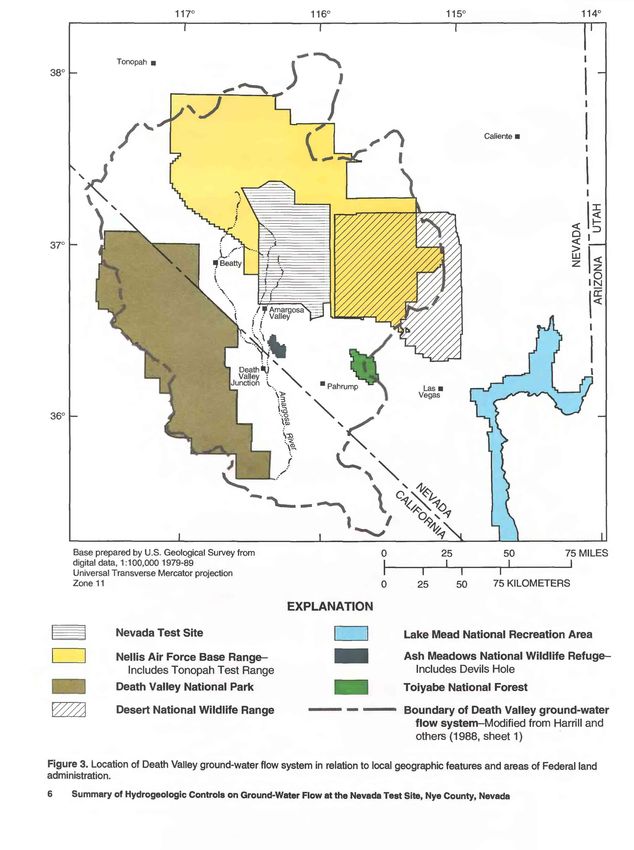
U.S. DEPARTMENT OF THE INTERIOR
BRUCE BABBITT, Secretary

U.S. GEOLOGICAL SURVEY
GORDON P. EATON, Director

Any use of trade names in this publication is for descriptive purposes
only and does not constitute endorsement by the U.S. Government

For additional information                                      Copies of this report can be
write to:                                                       purchased from:

District Chief                                                  U.S. Geological Survey
U.S. Geological Survey                                          Information Services
333 West Nye Lane, Room 203                                     Box 25286, MS 517
Carson City, NV 89706-0866                                      Denver Federal Center
                                                                Denver, CO 80225-0046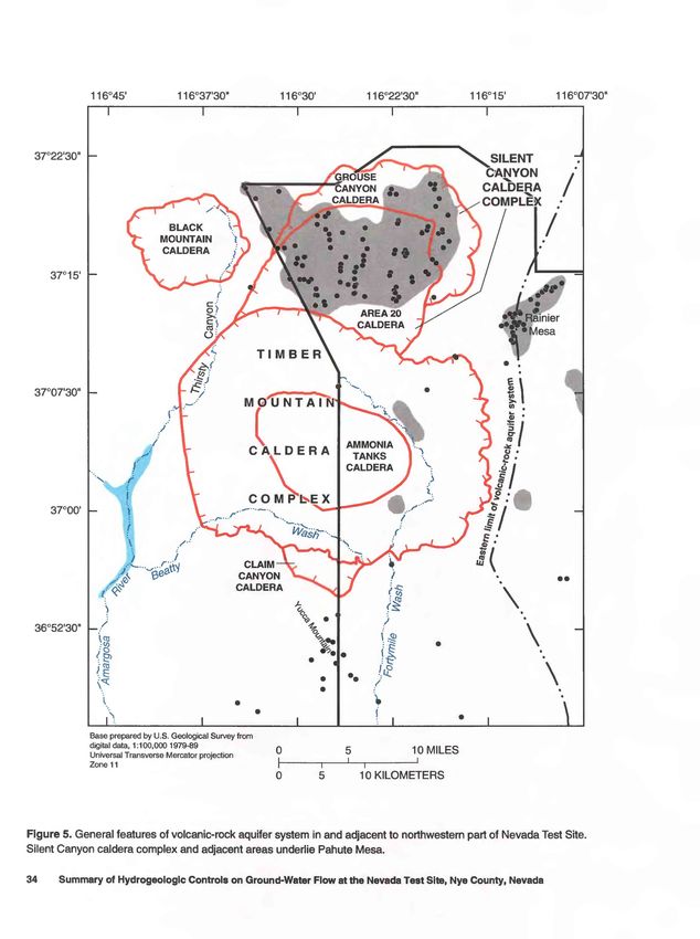
CONTENTS
Abstract.........................................................................................................._^                                                                        1
Introduction............................................................................................................................................................................    1
       Background................................................................................................................................................................           1
       Purpose and Scope.....................................................................................................................................................               7
Regional Flow System...........................................................................................................................................................             8
       Hydrogeologic Units..................................................................................................................................................               10
       Ground-Water Flow and Subbasins............................................................................................................................                         16
                 Ash Meadows Subbasin..................................................................................................................................                    16
                 Oasis Valley Subbasin ....................................................................................................................................                18
                 Alkali Flat-Furnace Creek Ranch Subbasin...................................................................................................                               19
                 Flow Rates and Simimary...............................................................................................................................                    20
Underground Test Areas........................................................................................................................................................             21
       Yucca Flat and Frenchman Flat..................................................................................................................................                     21
                  Hydrogeologic Units.......................................................................................................................................               23
                 Ground-Water Flow........................................................................................................................................                 26
       Pahute Mesa and Rainier Mesa..................................................................................................................................                      32
                 Hydrogeologic Units.......................................................................................................................................                33
                 Ground-Water Flow........................................................................................................................................                 37
       Effects of Underground Testing on Ground-Water Flow...........................................................................................                                      42
                 Yucca Flat and Frenchman Flat......................................................................................................................                       45
                 Pahute Mesa and Rainier Mesa ......................................................................................................................                       45
Summary and Considerations for Environmental Restoration..............................................................................................                                     50
References Cited....................................................................................................................................................................       54

PLATES
[Plates in pocket at back of report]

1. Map showing major controls on regional ground-water flow at and near Nevada Test Site, southern Nevada
          and southeastern California
2. Sections showing major controls on ground-water flow at and near Nevada Test Site, southern Nevada and
          southeastern California
3. Map showing major controls on ground-water flow and distribution of hydrogeologic units at water table in
          Yucca Flat and Frenchman Flat areas, southern Nevada
4. Map and sections showing water levels, underground tests, and principal water-bearing units in upper 2,000 feet
          of saturated rock in Pahute Mesa area, southern Nevada

FIGURES

1-6. Maps showing:
      1. Location of Nevada Test Site and local physiographic and geographic features.................................................... 3
      2. General areas of underground nuclear testing and other potential sources of subsurface contamination at
             Nevada Test Site............................................................................................................................................... 4
      3. Location of Death Valley ground-water flow system in relation to local geographic features and areas of
             Federal land administration.............................................................................................................................. 6
      4. Surface distribution of rocks in and near Nevada Test Site.................................................................................... 9
      5. General features of volcanic-rock aquifer system in and adjacent to northwestern part of Nevada Test Site........ 34
      6. Major controls on ground-water flow in Pahute Mesa area.................................................................................... 38
 7. Diagrammatic section showing mechanical and hydrologic effects that may result from underground test
       detonated below water table...................................................................................................................................... 43

                                                                                                                                                                     CONTENTS               III
8. Generalized longitudinal hydrogeologic section across central Yucca Flat showing mechanical effects
       of underground testing............................................................................................................................................... 46
  9. Map showing general areas within Yucca Flat where sustained, local hydrologic effects may have resulted
       from underground testing .......................................................................................................................................... 48

TABLES

1. Principal stratigraphic and associated hydrogeologic units of Nevada Test Site and vicinity .......................................... 11
2. Nomenclature for hydrogeologic units of Nevada Test Site and vicinity.......................................................................... 14
3. General characteristics of ground-water subbasins of Nevada Test Site and vicinity....................................................... 17
4. Distribution of underground tests relative to water table and estimated number of tests that have introduced
       test-generated contaminants into the ground-water flow system by major test area at the Nevada Test Site............ 22
5. Water levels, underground tests, and associated test and hole parameters used to determine general position
      of test relative to the water table................................................................................................................................. 30

CONVERSION FACTORS AND VERTICAL DATUM

                                       Multiply                                       By                                  To obtain

                                                                                   Length
                                        foot (ft)                                     0.3048                               meter
                                      mile (mi)                                        1.609                               kilometer
                                                                                    Area
                            square mile (mi2)                                         2.590                                square kilometer
                                                                                   Volume
                           acre-foot (acre-ft)                                   1,233                                     cubic meter
                             cubic mile (mi3)                                         4.168                                cubic kilometer
                                                                                 Flow Rate
                           foot per day (ft/d)                                        0.3048                               meter per day
                         foot per mile (ft/mi)                                        0.1894                               meter per kilometer
                         foot per year (ft/yr)                                        0.3048                               meter per year
                                                                          Volumetric Flow Rate
             acre-foot per year (acre-ft/yr)                                          0.001233                             cubic hectometer per year

Sea level: In this report, "sea level" refers to the National Geodetic Vertical Datum of 1929 (NGVD of 1929, formerly called "Sea-Level
Datum of 1929"), which is derived from a general adjustment of the first-order leveling networks of the United States and Canada.

IV      Summary of Hydrogeologic Controls on Ground-Water Flow at the Nevada Test Site, Nye County, Nevada
Summary of Hydrogeologic Controls
on Ground-Water Flow at the
Nevada Test Site, Nye County, Nevada
By Randell J. laczniak, James C. Cole, David A. Sawyer, and Douglas A. Trudeau
ABSTRACT great distances across this arid region. Unique
to the hydrology of NTS are the effects of under-
The underground testing of nuclear devices ground testing, which severely alter local rock
has generated substantial volumes of radioactive characteristics and affect hydrologic conditions
and other chemical contaminants below ground throughout the region.
at the Nevada Test Site (NTS). Many of the more Any assessment of the risk must rely in
radioactive contaminants are highly toxic and are part on the current understanding of ground-water
known to persist in the environment for thousands flow, and the assessment will be only as good as
of years. In response to concerns about potential the understanding itself. This report summarizes
health hazards, the U.S. Department of Energy, what is known and inferred about ground-water
under its Environmental Restoration Program, flow throughout the NTS region. The report iden-
has made NTS the subject of a long-term investi- tifies and updates what is known about some of the
gation. Efforts supported through the U.S. Depart- major controls on ground-water flow, highlights
ment of Energy program will assess whether some of the uncertainties in the current under-
byproducts of underground testing pose a potential standing, and prioritizes some of the technical
hazard to the health and safety of the public and, if needs as related to the Environmental Restoration
necessary, will evaluate and implement steps to Program.
remediate any of the identified dangers. An apparent deficiency in the current under-
Test-generated contaminants have been standing is a lack of knowledge about flow direc-
introduced over large areas and at variable depths tions and rates away from major areas of testing.
above and below the water table throughout NTS. Efforts are necessary to delineate areas of down-
Evaluating the risks associated with these byprod- gradient flow and to identify factors that constrain
ucts of underground testing presupposes a knowl- and control flow within these areas. These efforts
edge of the source, transport, and potential also should identify the areas most critical to gain-
receptors of these contaminants. Ground-water ing detailed understanding and to establishing
flow is the primary mechanism by which contami- long-term monitoring sites necessary for effective
nants can be transported significant distances remediation.
away from the initial point of injection. Flow paths
between contaminant sources and potential recep- INTRODUCTION
tors are separated by remote areas that span tens of
miles. The diversity and structural complexity of Background
the rocks along these flow paths complicates the
hydrology of the region. Although the hydrology Since the early 1950's, the Nevada Test Site
has been studied in some detail, much still remains (NTS) has been the primary continental location for
uncertain about flow rates and directions through testing of nuclear weapons by the United States and
the fractured-rock aquifers that transmit water for conducting experiments related to the peaceful
ABSTRACT 1application of nuclear explosions. The site, which The NTS is centrally located within the Death
occupies 1,350 mi2 of south-central Nevada (fig. 1), Valley ground-water flow system (fig. 3), one of the
was chosen by the Atomic Energy Commission (prede- major hydrologic subdivisions of the southern Great
cessor to the U.S. Department of Energy) primarily Basin. It is estimated that more than 70,000 acre-ft of
because of its remoteness from population centers and ground water are transmitted annually through this
because of Federal control over much of the land (U.S. geologically diverse region (Blankennagel and Weir,
Department of Energy, 1993, p. 1). Initially, nuclear 1973; Winograd and Thordarson, 1975; Harrill and
tests were detonated at or above land surface, but as the others, 1988; Dettinger, 1989). In general, water moves
concerns over atmospheric fallout intensified during southward through thick sequences of carbonate and
the late 1950's, more and more tests were detonated volcanic rocks, away from areas of major recharge in
below ground in tunnels and shafts. Since July 1962, central Nevada, toward areas of surface discharge at
and in accordance with the Limited Test Ban Treaty Ash Meadows, Oasis Valley, Alkali Flat, and Death
of 1963, all tests at NTS have been detonated beneath Valley (fig. 1). Along these pathways, rain and snow on
land surface (Office of Technology Assessment, 1989, some of the intermediate mountain ranges and higher
p. 11-27; U.S. Department of Energy, 1994). mesas contributes thousands of acre-feet of water into
Activities at NTS over the past 40 years have the underlying aquifers. Local communities and the
generated a substantial amount of hazardous waste, numerous commercial and Federal facilities located
both at the surface and underground (fig. 2). The larg- throughout the area must rely on ground water for a
est volume of contaminants was produced as a direct large part of their water supply because surface water
consequence of nuclear testing (Bryant and Fabryka- is limited in this arid region. Presently, wells through-
Martin, 1991). At NTS, 828 underground nuclear tests out the flow system provide for agricultural, livestock,
have been detonated (U.S. Department of Energy, industrial, and domestic water needs, as do springs,
1994), most of which (more than 95 percent) were at which also support a diversity of wildlife and native
Yucca Flat, Rainier Mesa, and Pahute Mesa (fig. 2). No vegetation.
tests have been detonated since October 1992. These A potential receptor of test-generated contami-
nuclear devices were emplaced deep in the earth to nants is the NTS workforce. More than 10 major water
contain their explosive force and radioactive byprod- wells have been developed at NTS to provide water
ucts within the subsurface, thus avoiding the release for drinking, industrial, and waste uses. Many of these
of radioactivity to the atmosphere. Even though water wells, along with other drill holes on the NTS (fig. 2),
levels in the NTS region are generally more than 800 ft have been sampled routinely for many years by the
below land surface, many of the intermediate and U.S. Department of Energy (USDOE) and the U.S.
larger yield tests were detonated at depths near or Environmental Protection Agency (USEPA). Samples
below the water table to ensure the subsurface contain- have been tested for radioactive and other chemical
ment of radioactive byproducts (fig. 2). These tests constituents (Office of Technology Assessment, 1989;
have resulted in the introduction of radioactive and U.S. Environmental Protection Agency, 1991). No fis-
chemical contaminants into the regional ground-water sion products have been detected in these samples, but
flow system. tritium has been measured at concentrations greater
Individual test-generated contaminants differ than background (but not exceeding USEPA regula-
considerably in terms of physical and chemical behav- tions for safe drinking water) in several of these wells.
ior and toxicity, and the after-shot distribution is diffi- As a result of the USDOE practice of regularly moni-
cult to define, in part because of dispersal by the test toring drilling fluids at NTS, tritium and fission prod-
explosion itself (Borg and others, 1976). Contaminants ucts have been detected in ground water at locations
produced by the detonation remain in the subsurface within the testing areas where none were expected
for many years. Where ground water contacts these (Borg and others, 1976; Hawkins and others, 1988,
contaminants, the potential for their migration is 1989; Nimz and Thompson, 1992). Although the con-
increased and their movement becomes dependent centrations of these contaminants generally have been
primarily on the rate and direction of ground-water low, tritium has been detected in excess of USEPA
flow. Thus, a knowledge of ground-water flow paths maximum permissible concentrations in a few samples
is essential to determine subsurface distributions and at Yucca Flat (Crow, 1976) and at Pahute Mesa (Erik-
potential receptors of these test-generated byproducts. son, 1991; Nimz and Thompson, 1992).
Summary of Hydrogeologic Controls on Ground-Water Flow at the Nevada Test Site, Nye County, Nevada116°30' 116°00'
37°30' r~
37°00'
36°30' h-
36°00'
Base from U.S. Geological Survey digital data, 1:250,000
Universal Transverse Mercator projection, Zone 11
0 10 20 30 KILOMETERS
EXPLANATION
I I Basin
li Mountainous area
NEVADA Nevada Test Site boundary
TEST SITE
Figure 1 . Location of Nevada Test Site and local physiographic and geographic features.
INTRODUCTION 3116°30' 116°00' 115°45'
Pahute Mesa
80/85
\
37°15'
-Yucca Flat
226/661
Buckboard Mesa
0/3
37°00' Dome Mountain -
0/1
Shoshone Mountain
0/6
29
14
Frenchman
Flat
26 10/10
36°45'
25 27
15 MILES
\ I
15 KILOMETERS
Base prepared by U.S. Geological Survey from
digital data, 1:100,000 1979-89
Universal Transverse Mercator projection
Zone 11
Figure 2. General areas of underground nuclear testing and other potential sources of subsurface contamination at Nevada
Test Site.
4 Summary of Hydrogeologic Controls on Ground-Water Flow at the Nevada Test Site, Nye County, NevadaEXPLANATION
^H Underground test area-Darker shading delineates area where tests
0/3 were detonated near or below water table. Number of tests near
or below water table and total number of tests are indicated
preceding and following slash, respectively. From Bryant
and Fabryka-Martin (1991) and U.S. Department of Energy
(1991,1994); see table 4 for additional information
Nevada Test Site boundary
3
Area boundary within Test Site-Area number is indicated
Other contaminant sources-From U.S. Department of Energy (1991)
X Tunnel tailings or drain pond
Leachfield
A Sump or injection well
* Storage tank
* Waste site
U.S. Environmental Protection Agency sampling well-From
U.S Environmental Protection Agency (1991)
Figure 2. Continued.
INTRODUCTION117° 116° 115° 114°
Tonopah
38°
CLr'
37°
36°
Base prepared by U.S. Geological Survey from 25 50 75 MILES
digital data, 1:100,000 1979-89 I I
Universal Transverse Mercator projection I I I
Zone 11 25 50 75 KILOMETERS
EXPLANATION
Nevada Test Site Lake Mead National Recreation Area
Nellis Air Force Base Range- Ash Meadows National Wildlife Refuge-
Includes Tonopah Test Range Includes Devils Hole
Death Valley National Park Toiyabe National Forest
Desert National Wildlife Range Boundary of Death Valley ground-water
flow system-Modified from Harrill and
others (1988, sheet 1)
Figure 3. Location of Death Valley ground-water flow system in relation to local geographic features and areas of Federal land
administration.
6 Summary of Hydrogeologic Controls on Ground-Water Flow at the Nevada Test Site, Nye County, NevadaWater users west and south of NTS also are con- between contaminant sources and potential receptors.
sidered potential receptors because they are downgra- Most quantitative estimates given for rates of ground-
dient of the contaminant sources. Ground water has water flow (Blankennagel and Weir, 1973, table 9;
been developed for drinking, livestock, agriculture, Winograd and Thordarson, 1975, tables 14 and 15;
mining, and waste use at numerous wells in Oasis Winograd and Pearson, 1976; Claassen, 1985, p. 29;
Valley, throughout the Amargosa Desert, and at the Brikowski, 1992, p. 18) do not necessarily represent
communities of Beatty, Springdale, and Amargosa flow rates along any specific flow path, but rather are
Valley, Nev., and Death Valley Junction and in the averages for large areas. Estimates of minimum flow
Death Valley National Park, Calif, (figs. 1 and 3). times and maximum exposure risks will not be possible
Springs and seeps in upper Oasis Valley near Beatty, until local flow systems are more fully explored and
in the Ash Meadows National Wildlife Refuge, and their hydrologic properties better quantified, and until
at Alkali Flat have sustained wetlands, which support hydrologic and geologic information is obtained from
a variety of wildlife and some recreational activities. areas beyond those that have been partially explored as
Further development of ground water from NTS and an outgrowth of the testing program.
adjacent areas is expected in response to continued
Federal activities at NTS and Nellis Air Force Range.
In addition, projected growth of the Las Vegas urban Purpose and Scope
area and some of the smaller communities throughout
the region may lead to the further development of water This report summarizes the current scientific
resources in the NTS area. understanding about ground-water flow beneath the
Radioactive and other potential chemical contam- NTS region, and highlights uncertainties in our knowl-
inants at NTS are the subject of a long-term program edge of hydrogeologic conditions in what is considered
of investigation and remediation by USDOE under its one of the more complex flow systems on the conti-
Environmental Restoration Program (U.S. Department nent. The report is not intended to endorse or dispute
of Energy, 1991, p. 2). Within the framework of appli- any specific remedial activity, but rather to provide
cable Federal and State regulations, the program will basic hydrologic and geologic information and a funda-
endeavor to assess the extent of contamination and to mental understanding of subsurface conditions, from
evaluate the potential risks to man and the environment which programs and policies can be developed and
from byproducts of testing. A more complete under- implemented to promote effective and efficient cleanup
standing of ground-water flow at NTS is essential to and ensure the long-term protection of ground-water
evaluate future environmental risk and to assess strate- resources.
gies for removing, containing, treating, and monitoring This report is based largely on published
any contaminants. reports of earlier hydrologic investigations by the U.S.
The identification and characterization of con- Geological Survey during the 1960's and 1970's; on
taminated ground water will be especially challenging published and unpublished reports documenting com-
at NTS because (1) contaminants have been introduced plimentary work done by other organizations; and on
in both saturated and unsaturated rock at variable published U.S. Department of Energy reports through
depths (50 to 4,800 ft below land surface); (2) the phys- 1992 documenting planning and strategies for environ-
ical and chemical conditions near the point of detona- mental restoration at NTS. Additional information
tion (contaminant source) are poorly known; (3) the from more recent geologic mapping and new structural
subsurface environment is hydrogeologically complex; interpretations in the region by the U.S. Geological
and (4) the contaminated areas are large and geologi- Survey, the University of Nevada-Reno, and others
cally diverse. Further, the interactions between radio- also is incorporated and referenced. Water-level data
active and chemical byproducts of testing and the presented throughout this report represent measured
ground-water flow system are not adequately under- values through 1991, but these levels are not every-
stood. A thorough understanding of specific flow paths where comparable from hole to hole because of differ-
is imperative to determine and implement a successful ences in hole construction and numerous other factors.
remediation program because of the high chemical tox- The hydrologic concepts and interpretations summa-
icity and radioactivity of many of the radionuclides. rized herein do not differ significantly from those pre-
Present data are inadequate to define specific pathways sented by Blankennagel and Weir (1973) and Winograd
INTRODUCTIONand Thordarson (1975). In part, this similarity is others, 1988). Ground water moves under the influence
because only a few additional hydrologic test holes of hydraulic gradients along convoluted pathways
have been completed within the NTS region since their between areas of recharge (characterized as areas of
investigations. higher precipitation) and areas of surface discharge
Because of the extent, geologic diversity, and (characterized by springs and wet playas). The move-
hydrologic complexity of the ground-water flow sys- ment of ground water along these flow paths is con-
tem in the NTS region, this report first describes the trolled largely by the water-transmitting characteristics
occurrence and movement of ground water at the of the host rock. These characteristics depend on the
regional scale. This is followed by a description of primary and secondary properties of the rock (princi-
the geology and hydrology of the primary areas of pally porosity and permeability). Primary properties
underground testing. The report also describes test- are those created during deposition of the rocks; and
induced effects on hydrogeologic conditions and some secondary properties are those created after deposition,
potential effects of testing on contaminant migration. usually as a result of faulting, fracturing, dissolution,
Although the report focuses mainly on the or the precipitation of mineral cements. Secondary
hydrogeologic features pertinent to the migration of properties associated with major geologic structures
contaminants away from areas of underground testing, throughout the region may exhibit significant control
additional non-test-related sources of contamination on the regional flow of ground water in some areas.
are present throughout NTS. These sources include The NTS lies totally within the Death Valley
low-level radioactive waste facilities, inactive storage ground-water flow system. The Death Valley flow sys-
tanks and waste-water sumps, and a few shallow tem covers an area of about 15,800 mi2 of the southern
liquid-waste injection wells (fig. 2; U.S. Department Great Basin between its principal recharge areas in the
of Energy, 1991). Tailings mined from tunnels into high mountains of central Nevada and its southernmost
Rainier Mesa also contain radioactive materials, as areas of discharge in Death Valley, Calif. (Harrill
does the mine drainage that flows into nearby surface and others, 1988). The flow system consists primarily
evaporation ponds and infiltrates through surficial soil of volcanic rock in the west and carbonate rock in the
zones. Large surface areas at NTS and at Nellis Air east (fig. 4) and is estimated to transmit more than
Force Base Range to the east contain plutonium- 70,000 acre-ft of ground water annually (Blankennagel
contaminated soils that resulted from early transporta- and Weir, 1973, p. 19-20; Winograd and Thordarson,
tion and safety tests in which nuclear warheads were 1975; Harrill and others, 1988, sheet 2; Dettinger,
destroyed by conventional explosives (U.S. Depart- 1989, p. 17-25). The largest part is conveyed through
ment of Energy, 1991, p. 142-146; 1994). Non-test a thick sequence of Paleozoic carbonate rock, referred
and test-generated radioactive materials noted above to as the "central carbonate corridor," that extends
may contribute contaminants to the regional aquifers, throughout the subsurface of much of central and
but the rate of influx probably is slowed by the thick southeastern Nevada (Dettinger, 1989, p. 13).
unsaturated zone and the limited recharge from precip-
itation. Although these sources also must be investi- Hydrogeologic information throughout most of
gated, they are not discussed in detail here because the area is scant because of the sparse population and
none is considered to contribute significant contamina- the difficulty and high cost associated with drilling
tion to the regional ground-water flow system. wells to the extreme depths required to reach the
regional water table. In contrast, some areas such as
NTS and a few small agricultural regions in the lower
REGIONAL FLOW SYSTEM Amargosa Desert have high concentrations of wells.
These wells have provided useful information to many
The NTS is within the southern Great Basin regional investigations, but many of the data were of
region, an internally drained part of the Basin and limited value because wells were not constructed for
Range physiographic province. The region is charac- the acquisition of hydrologic information. Thus,
terized by low rainfall, intermittent streams, internal present interpretations of regional ground-water flow
surface drainages, and large, sparsely distributed are limited by sparse and inconsistent hydrologic data,
springs. Several major flow systems convey ground regarding water levels, water chemistry, and the water-
water through this region (Rush, 1970; Harrill and bearing characteristics of rocks.
8 Summary of Hydrogeologic Controls on Ground-Water Row at the Nevada Test Site, Nye County, Nevada117°30' 117°00' 116°30' 116°00' 115°30'
37°30'
37°00' -
36°30'
36°00' -
Base prepared by U.S. Geological Survey from On Mil PQ Geology modified from Streitz and
digital data, 1:100,000 1979-89
0 10Hydrogeologic Units until late Devonian time, about 370 Ma, when uplift
west and north of NTS resulted in erosion of an off-
Ground water flowing beneath NTS passes shore volcanic arc and deposition of thick Mississip-
through a diverse assemblage of rocks (pis. 1 and 2) pian sandstones and shales in an active foreland basin
that differ substantially in terms of stratigraphic age, (Poole, 1974; Poole and Sandberg, 1991; Cole and oth-
lithologic composition, and water-bearing properties. ers, 1994). Compressional deformation during the
These rocks form a complex three-dimensional frame- Sevier orogeny (about 150 to 100 Ma) produced
work of ground-water conduits and barriers that can be regional thrusts, folds, and (probable) wrench faults
described as hydrogeologic units (aquifers and confin- that fundamentally rearranged the positions of Paleo-
ing units) on the basis of their ability to store and trans- zoic and older sedimentary rocks, both in terms of
mit water (table 1). This framework differs depth and geographic distribution (Armstrong, 1968;
significantly from a simple layer-cake model in that Barnes and Poole, 1968). Several lines of evidence
(1) the initial geometric shape of the rock units ranges suggest that the Sevier orogenic zone, including NTS,
from tabular to lenticular to cylindrical; (2) structural may have subsequently been extended by normal faults
and erosional modifications have changed the thick- prior to the intrusion of minor granites at about 100 Ma
ness and lateral continuity of most major rock units; (Hodges and Walker, 1992; Cole and others, 1993).
(3) hydrothermal alteration, contact metamorphism, Following erosion throughout most of the early
diagenesis, and thermal-mechanical effects of under- Tertiary period (65 to 30? Ma), the area in and around
ground testing have modified rock-hydraulic properties NTS began to be pulled apart along low-angle normal
to differing degrees locally; and (4) tectonic fracturing faults and strike-slip faults associated with the forma-
has altered permeability along fault zones. tive stages of the modern Basin and Range structural
Knowledge of this three-dimensional framework province (Guth, 1981, 1990; Hamilton, 1988;
has significant gaps, but regional studies provide the Wernicke and others, 1988; Cole and others, 1990).
basis for predicting the locations of major regional Eruptions of the southwest Nevada volcanic field
hydrogeologic units that convey most of the ground (fig. 4) began at about 16 Ma and continued without
water within the upper 5,000 to 7,000 ft of the Earth's major interruption until about 8 Ma (Byers and others,
crust. These major water-bearing units, first enumer- 1976; Sawyer and others, 1990; Sawyer and others,
ated by Winograd and Thordarson (1975), are revised 1994). Successive eruptions produced no less than
somewhat here and designated (1) the basement confin- seven large and partially overlapping calderas, which
ing unit, (2) the carbonate-rock aquifer, (3) the Eleana were filled with lava flows and blanketed by vast
confining unit, (4) the volcanic aquifers and confining deposits of tuff. In the central subsided block of the
units, and (5) the valley-fill aquifer (table 2). Although Silent Canyon caldera complex beneath Pahute Mesa,
each of these regional units has internal complexities for example, volcanic rock accumulated to a depth of
and although different parts of the NTS region are more than 13,000 ft (Byers and others, 1976). Exten-
strongly influenced by different combinations of units, sion continued during and after volcanic activity and
these major subdivisions are useful descriptive ele- caused further tilting and lateral translation of major
ments of the overall conceptual framework. upper crustal blocks in some places. Modern alluvial
The rocks that make up these major regional basins (about 10 Ma to present) have progressively
hydrogeologic units include parts of a thick sequence filled with as much as 4,000 ft of coarse gravel and
(more than 35,000 ft) of Paleozoic and older sedimen- sand, and locally fine grained playa-lake deposits of
tary rocks (about 600 to more than 280 million years silt and clay.
before present [Ma]), local intrusive bodies of Creta- The lowermost 10,000 ft of the pre-Tertiary
ceous granite (about 100 Ma), a thick and variable section consists of Eocambrian to Middle Cambrian
assemblage of Miocene volcanic rocks (about 16 to quartzite, micaceous quartzite, and siltstone. Together
8 Ma), and locally thick deposits of post-volcanic these units make up subregional quartzite confining
gravel and sand that fill the valleys (Frizzell and unit (table 2) that functions as the lower confining zone
Shulters, 1990). (hydrologic basement) throughout much of the Death
Major structural events also have left their Valley flow system because of its generally low water-
imprint on the rocks of the area. This region of the transmitting characteristics. Where exposed by uplift hi
western United States was a stable continental margin the northern Halfpint, Groom, Papoose, and Desert
10 Summary of Hydrogeologic Controls on Ground-Water Flow at the Nevada Test Site, Nye County, NevadaTable 1. Principal stratigraphic and associated hydrogeologic units of Nevada Test Site and vicinity
[Based on information from Blankennagel and Weir, 1973, table 1; Winograd and Thordarson, 197S, table 1; Byers and others, 1976; Cole and others, 1990;
Sawyer and others, 1990; Sawyer and others, 1994; and R.G. Warren, Los Alamos National Laboratory, written commun., 1991]
Stratigraphic unit1 Principal lithology2 Hydrogeologic unit3 Known or inferred
hydrologic significance4
Generally unsaturated except in deepest
structural basins at Yucca Flat, Frenchman
Flat, Emigrant Valley, and Amargosa
Valley-fill deposits Desert. Saturated thickness highly vari-
Gravel and sand (eolian sand able and can exceed 1,000 ft locally; local
[Qa, QTa, Qp, Qe, Qc] Valley-fill aquifer
Miocene to Quaternary and lakebed deposits) source of recharge to regional carbonate-
rock aquifer. Fine-grained lakebed depos-
its present- in Ash Meadows area may
inhibit regional flow and divert ground
water to surface [AM, OV, AFFCR]
Basalt Generally unsaturated; dikes and local flows
[Qb, QTb, Tb] Basalt in thin flows, dikes,
n/c may influence local ground-water move-
Miocene to Quaternary and cinder cones
ment [OV, AFFCR, AM]
Thirsty Canyon Group Variable welded peralkaline Generally unsaturated; may contain local
[Tt] rhyolite ash-flow tuff Welded-tuff aquifer perched water in Pahute Mesa and
9.4 Ma (trachyte lava) beneath Oasis Valley [OV, AFFCR]
Generally unsaturated except in Oasis Val-
Variable welded ash-flow tuff ley and possibly Jackass Flats [OV,
Ammonia Tanks Tuff Welded-tuff aquifer
(bedded tuff)
AFFCR?]
Rhyolite of Local aquifer in northwestern part of Timber
Rhyolite lava Lava-flow aquifer Mountain caldera [AFFCR, OV]
Timber Mountain Group Tannenbaum Hill
[Tm] Major aquifer in deeper parts of Yucca Flat,
12.5- 11. 5 Ma Variably welded ash-flow tuff CP Basin, Frenchman Flat, and Jackass
Rainier Mesa Tuff (nonwelded tuff; rhyolite Welded-tuff aquifer Flats, and in western Pahute Mesa and
lava) Oasis Valley [AM, AFFCR, OV]
Pre-Rainier Mesa Rhyolite lava (nonwelded Lava-flow aquifer Local aquifers in Pahute Mesa and at Yucca
rhyolites tuff) Mountain [AFFCR]
Generally unsaturated; may form local aqui-
Post-Tiva Canyon Rhyolite lava (nonwelded fers in fault blocks in western and central
Lava-flow aquifer
rhyolites tuff) Pahute Mesa; contains perched water else-
where [OV, AFFCR]
Variably welded ash-flow tuff Major aquifer in Pahute Mesa and Jackass
Welded-tuff aquifer
Tiva Canyon Tuff (nonwelded tuff; locally Flats; confining unit where nonwelded in
(tuff confining unit)
Paintbrush Group zeolitized) Yucca Flat [AFFCR, AM]
[Tp] Middle Paintbrush
12.8-12.7 Ma Lava-flow aquifer
Group rhyolites Rhyolite lava (welded ash-
(welded-tuff Local aquifers in Pahute Mesa; minor con-
(includes rhyolites flow tuff; nonwelded tuff,
aquifer; tuff fining .unit at Yucca Mountain [AFFCR]
of Echo Peak and locally zeolitized)
confining unit)
Silent Canyon)
Variably welded ash-flow tuff Major aquifer in western Pahute Mesa, Jack-
Welded-tuff aquifer
Topopah Spring Tuff (nonwelded tuff, locally ass Flats, southern Yucca Flat, CP Basin,
(tuff confining unit)
zeolitized) and Frenchman Flat [OV, AFFCR, AM]
Lava-flow aquifer, Major aquifer in central and western Pahute
Rhyolite lava and nonwelded
tuff confining unit Mesa; major confining unit in eastern
Calico Hills Formation Volcanics of Area 20 tuff, commonly zeolitized
(welded-tuff Pahute Mesa, Yucca Mountain, Jackass
[Ta] (welded tuff)
aquifer) Flats, and Yucca Flat [AFFCR, OV?]
12.9 Ma
Major aquifer in eastern and central Pahute
Rhyolite of Inlet Rhyolite lava Lava-flow aquifer
Mesa [AFFCR, OV?]
REGIONAL FLOW SYSTEM 11Table 1. Principal stratigraphic and associated hydrogeologic units of Nevada Test Site and vicinity Continued
Stratigraphic unit1 Principal IHhology2 Hydrogeologic unit3 Known or inferred
hydrologic significance4
Confining unit west of Frenchman Flat and
Wahmonie Formation Andesite and dacite volcanic Tuff confining unit in Jackass Flats; contains perched water
[Tw] breccia (lava; nonwelded (lava-flow aquifer near Cane Springs and Pavits Spring; thin
13.0 Ma tuff) or confining unit?) confining unit in Yucca Flat [AM,
AFFCR]
Variably welded ash-flow tuff Major aquifer at Yucca Mountain; confining
Welded-tuff aquifer
Prow Pass Tuff (nonwelded tuff, unit where nonwelded in Yucca Flat and
(tuff confining unit)
commonly zeolitized) Rainier Mesa [AFFCR, AM]
Local aquifers in Pahute Mesa; confining
Rhyolite lava (latite lava;
Crater Flat Group Middle units Lava-flow aquifer units where nonwelded and zeolitized
nonwelded tuff)
[Tc] [AFFCR^M]
13.25-13.1Ma Variably welded ash-flow tuff Major aquifer at Yucca Mountain; major
Welded-tuff aquifer
Bullfrog Tuff (nonwelded tuff, confining unit in Pahute Mesa [AFFCR,
(tuff confining unit)
commonly zeolitized) AM]
Major aquifer at Yucca Mountain [AFFCR,
Tram Tuff Variably welded ash-flow tuff Welded-tuff aquifer
AM]
Rhyolite lava and variably
Deadhorse Flat welded ash-flow tuff Lava-flow aquifer; Major aquifers in eastern Pahute Mesa
Belted Range Group Formation (nonwelded tuff, welded-tuff aquifer [AFFCR, OV?]
[Tb] commonly zeolitized)
13.85-13.6 Ma Peralkaline welded ash-flow
Welded-tuff aquifer Local aquifer in Yucca Flat and Pahute
Grouse Canyon Tuff tuff (nonwelded tuff,
(tuff confining unit) Mesa [AFFCR, AM, OV]
commonly zeolitized)
Tunnel Formation Major confining unit in Rainier Mesa and
Nonwelded tuff, commonly Yucca Flat; contains perched water at
[Tn] Tuff confining unit
zeolitized
about 14 Ma Rainier Mesa [AFFCR, AM]
Rhyolite of Quartet Local aquifer in eastern Pahute Mesa
Peralkaline rhyolite lava Lava-flow aquifer
Volcanics of Big Dome Dome [AFFCR]
[Tu] Local aquifer in northern Yucca Flat and in
about 15 Ma Tub Spring Tuff Variably welded ash-flow tuff Welded-tuff aquifer parts of Pahute Mesa and Rainier Mesa
[AFFCR, AM]
Confining unit in Rainier Mesa and Yucca
Tunnel bed 2 and Nonwelded tuff, commonly
Tuff confining unit Flat; contains perched water at Rainier
Tunnel bed 1 zeolitized
Mesa [AFFCR, AM]
Older volcanics Major confining unit where nonwelded in
[To] southern Yucca Flat and Frenchman Flat;
Red Rock Valley
16-15 Ma Variably welded ash-flow tuff; Tuff confining unit local aquifers in northern Yucca Flat,
Tuff, Fraction
nonwelded tuff, commonly (welded-tuff southern Rainier Mesa, and parts of
Tuff, and pre-
zeolitized aquifer) Pahute Mesa. Unit locally includes ash-
fraction tuffs
flow tuffs of older mid-Tertiary volcanic
centers [AFFCR, AM]
Tuffaceous sandstone; local Significance unknown; mapped as an infor-
Pavits Spring Formation
conglomerate and siltstone mal unit east, south, and west of French-
[Ts] n/c
Miocene (ash-fall tuff; lacustrine man Flat; partly coeval with some other
limestone) volcanic units [AM]
Horse Spring Formation Conglomerate and tuffaceous Significance unknown; mapped as an infor-
[Ts] sandstone (lacustrine n/c mal unit south and west of Frenchman
mid-Tertiary limestone; ash-fall tuff) Flat along Rock Valley fault system [AM]
12 Summary of Hydrogeologic Controls on Ground-Water Row at the Nevada Test Site, Nye County, NevadaTable 1. Principal stratigraphic and associated hydrogeologic units of Nevada Test Site and vicinity Continued
Stratigraphic unit1 Hydrogeologic unit3 Known or inferred
Principal lithology2 hydrologic significance4
Locally very porous; thickness variable
along basal contact of Tertiary section;
Paleocolluvium
only known from Yucca Flat and Rainier
[Tx] Sedimentary breccia n/c
Mesa areas; hydrologic significance
Tertiary
uncertain but known to act as a local con-
fining unit in Yucca Flat [AM, AFFCR]
Relatively impermeable; forms local cylin-
Granite
drical stocks north of Rainier Mesa and
[Kg] Porphyritic monzogranite n/c
Yucca Flat; locally yields water from frac-
Cretaceous
ture zones [AFFCR, AM]
Tippipah Limestone
Thin-bedded limestone Upper carbonate-rock Local aquifer in western Yucca Flat; limited
[PIPt]
(pebble conglomerate) aquifer lateral extent [AM]
Chiefly Pennsylvania
Major confining unit along boundary
Eleana Formation Siliceous siltstone; chert between AFFCR and AM subbasins in
[MDe] sandstone; cobble western Yucca Flat and northern Jackass
and Chainman Shale conglomerate (shale; Eleana confining unit Flats; saturated thickness variable and can
[Mch] quartzite; bioclastic exceed 5,000 ft at some locations; locally
Chiefly Mississippian limestone) yields water from fracture zones in quartz-
ite and limestone [AFFCR, AM]
Guilmette Formation
Limestone, locally sandy and
[Dg] dolomitic
Devonian
Simonson Dolomite Regional carbonate-rock aquifer; saturated
Dolomite, locally silty or thickness can exceed 15,000 ft; conveys
[Ds]
cherty most ground water in Yucca Flat-French-
Devonian
man Flat area and along Rock Valley fault
Sevy, Laketown, and Lone Mountain Dolomite; system; principal aquifer throughout Ash
Roberts Mountain Formation; dolomite of Meadows subbasin; significant aquifer in
Dolomite, locally silty or
Spotted Range southern part of Yucca Mountain and
cherty
[various symbols] south into AFFCR subbasin [AM,
Chiefly Silurian and Devonian AFFCR]
Ely Springs Dolomite
[Oes] Dolomite, cherty dolomite
Ordovician
Eureka Quartzite Lower carbonate-rock
[Oe] Siliceous orthoquartzite aquifer
Ordovician
Pogonip Group
Limestone and silty Due to displacement on low-angle faults,
[Op] limestone (dolomite)
Ordovician carbonate rocks of these stratigraphic
units occur locally out of stratigraphic
Nopah Formation Limestone and dolomite, order above Eleana Formation or Chain-
[ n] locally cherty and silty;
man Shale; in such situations, structural
Cambrian Dunderberg Shale at base
blocks of these units do not form lower
Bonanza King Formation carbonate-rock aquifer, but rather act sim-
Dolomite and limestone (silty
[ bk] ilar to upper carbonate-rock aquifer
dolomite; chert)
Cambrian
Carrara Formation
[ c] [upper part] Limestone and silty limestone
Cambrian
REGIONAL FLOW SYSTEM 13Table 1 . Principal stratigraphic and associated hydrogeologic units of Nevada Test Site and vicinity Continued
Stratigraphic unit1 Known or inferred
Principal lithology2 Hydrogeologic unit3 hydrologic significance4
Carrara Formation
Shale and siltstone
[ c] [lower part] (limestone and quartzite)
Cambrian
Zabriskie Quartzite Widespread confining unit that forms hydro-
[ z] Siliceous orthoquartzite logic basement throughout much of south-
Cambrian ern Nevada; saturated thickness can
exceed 10,000 ft; forms major barrier to
Wood Canyon Formation Micaceous siltstone and
lateral ground-water flow in northeastern
[ Zw] orthoquartzite (dolomite; Quartzite confining Yucca Flat, south of Oasis Valley near
Cambrian and Eocambrian pebbly quartzite) unit Beatty, and south of Ash Meadows;
Stirling Quartzite Siliceous orthoquartzite and locally yields substantial water from frac-
[Zs] micaceous siltstone tured quartzite or fault zones in northern
Eocambrian (quartzite conglomerate) Yucca Flat [OV, AFFCR, AM]
Johnnie Formation Siliceous orthoquartzite and
[Zj] micaceous siltstone (silty
Eocambrian limestone)
Noonday Dolomite Known only from bottom of deep drillhole
[Zn?] Dolomite n/c UE-15d in northern Yucca Flat; strati-
Eocambrian graphic identity uncertain (Barnes, 1962)
1 Map symbol shown in brackets. Approximate age given in millions of years ago (Ma) or indicated by geologic system.
2 Rock type listed in order of decreasing prevalence; minor but significant rock types listed in parentheses.
3 Hydrogeologic units in order of decreasing prevalence. Stratigraphic classification of Tertiary volcanic rocks is based on age and composition. Litho-
logic and hydrologic properties may be extremely variable from place to place, n/c, stratigraphic unit has not been characterized as a hydrogeologic unit, gen-
erally because its presence in the unsaturated zone is minor.
4 Code in brackets at end of entry gives ground-water subbasin or subbasins in which stratigraphic units is prevalent. AFFCR, Alkali Flat-Furnace Creek
Ranch; AM, Ash Meadows; and OV, Oasis Valley. Query indicates uncertainty regarding presence or significance of unit in subbasin.
Table 2. Nomenclature for hydrogeologic units of Nevada Test Site and vicinity
Regional Subregional Equivalent previous units
hydrogeologic unit hydrogeologic unit (Winograd and Thordarson, 1975)
Valley-fill aquifer Valley-fill aquifer1 Valley-fill aquifer
Weided-tuff aquifer1 Welded-tuff aquifer
Volcanic-rock aquifer Bedded-tuff aquifer
Lava-flow aquifer1 Lava-flow aquifer
TViff confining unit1 1\iff aquitard
Volcanic confining unit
Lava-flow aquitard
N/R2" Granite1 Minor aquitard
N/R2 Upper carbonate-rock aquifer1 Upper carbonate-rock aquifer
Eleana confining unit Eleana confining unit Upper clastic aquitard
Carbonate-rock aquifer Lower carbonate-rock aquifer Lower carbonate-rock aquifer
Basement confining unit Quartzite confining unit Lower clastic aquitard
1 Due to original lenticular or interlayed form of constituent rock bodies, or due to geometric modifications caused by faulting
or folding, or both, these hydrogeologic units generally consist of more than one disconnected or partially connected aquifer or con-
fining unit.
2 N/R, no regional hydrogeologic unit is recognized because corresponding Subregional units have limited area! extent and do
not substantially effect regional ground-water flow.
14 Summary of Hydrogeologic Controls on Ground-Water How at the Nevada Test Site, Nye County, NevadaRanges, the northwestern Spring Mountains, and the One assemblage consists of Pennsylvanian limestone
north end of Bare Mountain, the quartzite confining (Tippipah Limestone in table 1) that depositionally
unit impedes the movement of ground water (Wino- overlies the Chainman Shale in the core of a syncline
grad and Thordarson, 1975, pi. 1). Its effectiveness as along the western margin of Yucca Flat. The second
a barrier is evidenced by steep hydraulic gradients assemblage consists of older heterogeneous carbonate
across these exposures (pi. 1; Waddell and others, rocks that lie structurally above the Eleana confining
1984, pi. 3). unit as a result of thrust faulting or low angle normal
Cambrian through Devonian rocks that make up faulting (Cole and others, 1990, 1994). The lateral
the lower (regional) carbonate-rock aquifer consist of extent and hydraulic connection of these rock assem-
15,000 ft of dolomite, interbedded limestone, and thin blages are largely unknown. In many locations east and
but persistent shale and quartzite layers. These carbon- south of NTS, the Eleana confining unit is not present
ate rocks are the most transmissive materials within the and all Paleozoic carbonate rocks, regardless of age,
Death Valley flow system because they are soluble in function as a single integrated hydrogeologic unit and
ground water (Dettinger, 1989, p. 5) and because late are collectively denoted the regional carbonate-rock
Cenozoic tectonic activity in the region has created aquifer in this report.
abundant secondary permeability in fractures (Wino- The rocks that make up the volcanic aquifers and
grad and Thordarson, 1975, p. 74). This aquifer is par- volcanic confining units generally are restricted geo-
ticularly important to the movement of water between graphically to the area of the southwest Nevada volca-
the underground test areas of Yucca and Frenchman nic field (fig. 4). This Miocene rhyolitic eruptive center
Flats and discharge areas in Ash Meadows and Death produced an overlapping complex of roughly cylindri-
Valley (fig. 4). Thin confining beds contained within cal caldera vents in the general area of Timber Moun-
the aquifer, such as the Dunderberg Shale and Eureka tain and Pahute Mesa, and laterally extensive tabular
Quartzite (table 1), do not appear to be regionally effec- outflow sheets of welded tuff (Byers and others, 1976).
tive confining units because faulting has disrupted their Water-bearing properties of these volcanic deposits are
continuity; however, they may impede ground-water governed chiefly by the mode of eruption and cooling,
flow locally (Winograd and Thordarson, 1975, p. 74). by the extent of primary and secondary fracturing, and
Whereas the quartzite confining unit and the by the degree to which secondary alteration (crystalli-
lower carbonate-rock aquifer are regionally extensive, zation of volcanic glass and zeolite alteration) have
the Eleana confining unit forms a narrow arcuate band affected primary permeability. The volcanic units,
in the subsurface that persists along the west side of therefore, tend to be geometrically complex, and their
Yucca Flat to CP Hills, where it swings westward hydrologic characteristics more difficult to predict than
across northern Jackass Flats and the north end of the pre-Tertiary sedimentary rocks, because strati-
Yucca Mountain to Bare Mountain (fig. 4). The Eleana graphic position does not correlate with hydrologic
Formation, for which the unit is named, consists of properties (table 1). Dense rocks with abundant frac-
low-permeability siliceous siltstone, sandstone, and tures make up the main elements of the volcanic aqui-
conglomerate (minor limestone) that may be as thick as fers, which consist of welded-tuff sheets outside the
6,500 ft along the axis of the arc. The Eleana Formation calderas and lava flows and thick welded-tuff bodies
grades laterally into the Chainman Shale (possibly within the calderas. The confining units are formed
4,000 ft thick; Cole and others, 1994) toward the east generally by the zeolitically altered nonwelded-tuff
and south as a result of primary depositional facies units, which are more common in the older, deeper
trends. Rocks of equivalent Mississippian age near parts of the volcanic section (Winograd and Thordar-
Mercury are less than 1,300 ft thick and composed son, 1975, p. 44; Byers and others, 1976).
chiefly of limestone that was deposited on a carbonate Valley-fill aquifers are formed by detrital gravel
bank (Poole and others, 1961; Barnes and others, and sand that fill modern basins of the area. These aqui-
1982). fers are characterized by high porosity and permeabil-
Two assemblages of rocks, designated as the ity where saturated, but few basins are deep enough
upper carbonate-rock aquifer, are present in a few loca- that a significant volume of alluvium is beneath the
tions within the Death Valley ground-water flow sys- water table. Downgradient from NTS testing areas,
tem and probably do not exert significant control on the the alluvium is saturated only in central and southern
regional flow of ground water in the NTS region. Yucca Flat, in Frenchman Flat, in Jackass Flats, and in
REGIONAL FLOW SYSTEM 15the Amargosa Desert. The valley-fill aquifer may be areas (fig. 2). The regional carbonate-rock aquifer
important in Oasis Valley, southwest of the Pahute is the major aquifer in the subbasin (pis. 1 and 2),
Mesa test area, but little is known of the subsurface although the valley-fill aquifer in the Ash Meadows
geology. region and the valley-fill and volcanic aquifers at Emi-
grant Valley, Yucca Flat, and Frenchman Flat also are
important locally.
Ground-Water Flow and Subbasins
Ground water in the subbasin discharges at Ash
Regional interpretations of ground-water flow Meadows from a line of springs about 10 mi long that
within the NTS area are based on the concept of generally coincides with the trace of a buried fault. The
ground-water subbasins. A ground-water subbasin spring line is about 40 mi downgradient of the Yucca
defines the area that contributes water to a major sur- Flat underground test area. Springflow has been esti-
face discharge. Subbasins are delineated primarily on mated at 17,000 acre-ft/yr (Walker and Eakin, 1963,
the basis of (1) the location of major discharge areas p. 21-24; Winograd and Thordarson, 1975, p. 78).
(springs and wet playas), (2) the location of recharge These springs support many plants indigenous to this
areas (zones of substantial precipitation), (3) occur- area only. Devils Hole, a collapse feature along a local
rences of rocks with low water-transmitting potential fault, provides the only natural habitat for the endan-
(low permeability), (4) regional hydraulic gradients gered Devils Hole pupfish.
determined from measurements of water level, and Water also leaves the subbasin through evapo-
(5) comparisons of the chemical and isotopic composi- transpiration (pis. 1 and 2). Annual evapotranspiration
tion of water. Ground-water levels near NTS range in from the Ash Meadows area has been estimated at
altitude from about 6,000 ft beneath the Kawich Range 10,500 acre-ft (Walker and Eakin, 1963, p. 21-24;
to below sea level at Death Valley (pi. 1). Four major Winograd and Thordarson, 1975, p. 84). The estimate
areas of ground-water discharge are downgradient of is based on transpiration rates determined for similar
NTS the Oasis Valley and Ash Meadows discharge phreatophytes found in other arid regions. Winograd
areas in Nevada, and the Alkali Flat and Death Valley and Thordarson (1975, p. 84) suggest that the source of
(Furnace Creek Ranch) discharge areas in California. evapotranspired water is primarily recycled spring-
Ground water beneath NTS is likely to flow to flow; but they do not dismiss the possibility that some
each of the discharge areas mentioned above. Three ground water available to plants in the areas may be
principal ground-water subbasins were identified derived instead by shallow ground water fed by upflow
within the NTS region by Waddell and others (1984, from the underlying carbonate-rock aquifer, nor do
p. 36). The subbasins, named for their downgradient they reject the possibility that their estimates of annual
discharge areas, are (1) Ash Meadows, (2) Oasis Val- transpiration may be low. Another likely area of evapo-
ley, and (3) Alkali Flat-Furnace Creek Ranch (pi. 1). transpiration is northeast of Ash Meadows around
Subbasin delineation is based on sparse and inconsis- Amargosa Flat (fig. 1, pi. 1). Here, like Ash Meadows,
tent data and the exact location of subbasin boundaries the water table is less than a few tens of feet and is in
is not known precisely. Subbasins, as shown on plate 1, the valley-fill aquifer. Water levels are maintained pri-
are intended only to illustrate regional flow concepts, marily by upflow from the underlying carbonate-rock
and should not be used to infer or estimate specific flow
aquifer. The community of phreatophytes present
paths. The general characteristics of each subbasin are
around the eastern edge of the playa are supported
summarized in table 3.
by, and transpire, the shallow ground water. Although
evapotranspiration has not been directly quantified
Ash Meadows Subbasin from this area, Winograd and Thordarson (1975,
p. 84-85) believe annual upflow into the valley-fill
The Ash Meadows subbasin includes the eastern
aquifer to be less than 1,000 acre-ft.
half of NTS and adjoins the Alkali Flat-Furnace Creek
Ranch subbasin along its western boundary (pi. 1). The Ground water is withdrawn from wells scattered
subbasin covers an area of about 4,000 mi2 that throughout the Ash Meadows subbasin. Pumped wells
includes Yucca Flat, Frenchman Flat, and parts of Sho- on NTS within the subbasin are used to withdraw
shone Mountain and Rainier Mesa underground test about 50 percent of the facility's total water needs
16 Summary of Hydrogeologic Controls on Ground-Water Flow at the Nevada Test Site, Nye County, NevadaYou can also read