Murray-Darling Basin Plan Long-term watering plan for the Water Plan (Border Rivers and Moonie) 2019 - February 2019
←
→
Page content transcription
If your browser does not render page correctly, please read the page content below
Murray–Darling Basin Plan
Long-term watering plan for the Water Plan (Border
Rivers and Moonie) 2019
February 2019
© State of Queensland, 2019

The Queensland Government supports and encourages the dissemination and exchange of its information. The copyright in
this publication is licensed under a Creative Commons Attribution 4.0 International (CC BY 4.0) licence.

Under this licence you are free, without having to seek our permission, to use this publication in accordance with the licence
terms.

You must keep intact the copyright notice and attribute the State of Queensland as the source of the publication.

Note: Some content in this publication may have different licence terms as indicated.

For more information on this licence, visit https://creativecommons.org/licenses/by/4.0/.

The information contained herein is subject to change without notice. The Queensland Government shall not be liable for
technical or other errors or omissions contained herein. The reader/user accepts all risks and responsibility for losses,
damages, costs and other consequences resulting directly or indirectly from using this information.
Acknowledgement of the Traditional Owners of the Border
Rivers and Moonie water plan area
The Queensland Government acknowledges and pays respect to the Traditional Owners in the
Border Rivers and Moonie area of Queensland. The contributions of earlier generations, including the
Elders, who passed on their knowledge of natural resource management, are valued and respected.

The Queensland Government acknowledges that the Traditional Owners of this region have a deep
cultural connection to their lands and waters and that there is a need to recognise Traditional Owner
knowledge and cultural values in water planning.
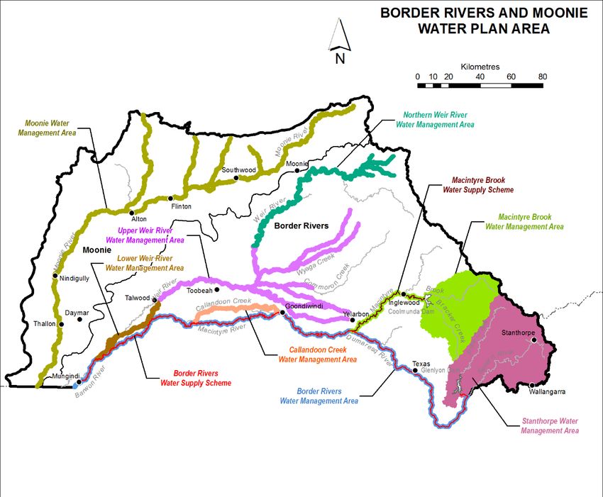
Table of contents
1       Purpose ......................................................................................................................................... 4
2       Background................................................................................................................................... 5
2.1     Queensland water planning framework .......................................................................................... 5
2.2     Queensland water plans ................................................................................................................. 5
2.3     Queensland water management protocols and operations manuals ............................................. 6
2.4     Border Rivers intergovernmental agreement ................................................................................. 7
2.5     Queensland’s rules-based approach to environmental water ........................................................ 7
2.6     The Border Rivers and Moonie water plan area ............................................................................ 8
2.7     Water resource development in the water plan area ..................................................................... 9
3       Queensland’s approach to the long-term watering plan ........................................................ 11
3.1     Aligning Basin Plan terminology to the Queensland water planning framework .......................... 13
3.2     Selecting priority environmental assets and ecological functions ................................................ 13
3.3     Identifying environmental watering requirements, and developing ecological targets ................. 15
                         Additional water plan measures and rules to achieve environmental
        outcomes/ecological objectives .................................................................................................... 16
4       Long-term watering plan for the Border Rivers and Moonie water plan area ...................... 17
4.1     Operational rules to protect environmental flows ......................................................................... 23
5       Held environmental water.......................................................................................................... 26
5.1     Strategies for environmental watering .......................................................................................... 26
5.2     Store and release guidelines ........................................................................................................ 26
6       Long-term risks to environmental assets and ecological functions .................................... 27
6.1     Identification of risks ..................................................................................................................... 27
6.2     Strategies for mitigating risks risks—Queensland water planning framework ............................. 29
7       Additional strategies for mitigating risks after water plan implementation ......................... 31
7.1     Rationale and methods used to assess threats ........................................................................... 32
7.2     Threat assessment for the Border Rivers and Moonie water plan area....................................... 34
7.3     Climate change ............................................................................................................................ 40
8       Consultation and co-operative arrangements ......................................................................... 41
9       Operational constraints ............................................................................................................. 42
10      Consistency with the Basin Plan .............................................................................................. 43
11      List of supporting information .................................................................................................. 45
Appendix 1—Consistency with Basin Plan methods in Chapter 8, Part 5 .................................... 47
Appendix 2—Environmental assets and ecological functions and their reference to Basin Plan
criteria and the Basin-wide environmental watering strategy........................................................ 53
Appendix 3—Consistency with the Basin Plan principles in Chapter 8, Part 4, Division 6 ........ 58
Appendix 4—List of environmental flow objectives and performance indicators for the plan
area ...................................................................................................................................................... 62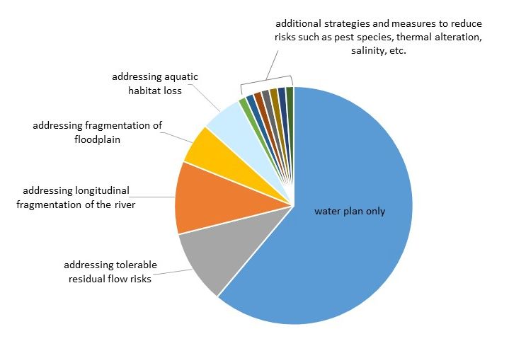
Table of figures
Figure 1. Map of the Border Rivers and Moonie water plan area ........................................................... 9
Figure 2. Queensland’s approach to developing a long-term watering plan. ....................................... 12
Figure 3. Examples of ecological assets and their links to different facets of the flow regime ............. 14
Figure 4. Conceptual representation of all management strategies that could contribute to reduce
risks to water plan ecological outcomes. The large blue segment represents risks that are managed
by a Queensland water plan. ................................................................................................................ 32
Figure 5. Examples of pressures, stressors and responses beyond those managed by a Water
Plan. ...................................................................................................................................................... 33

Table of tables
Table 1. Water supply schemes in the Border Rivers and Moonie water plan area ............................. 10
Table 2 - Alignment of Basin Plan terminology with Queensland water planning framework .............. 13
Table 3. Surface water environmental assets or ecological functions in the Border Rivers and Moonie
water plan area ..................................................................................................................................... 14
Table 4. Long-term watering plan for the Border Rivers and Moonie water plan area ......................... 17
Table 5. Operational rule — Environmental share for the Border Rivers water management area ..... 23
Table 6. Operational rule — Preservation of tributary inflow for Border Rivers .................................... 23
Table 7. Operational rule — Change in rate of release (Macintyre Brook Water Supply Scheme)...... 23
Table 8. Operational rule — Releases to provide for environmental flows (Macintyre Brook Water
Supply Scheme) .................................................................................................................................... 24
Table 9. Operational rule — Waterhole management (Macintyre Brook Water Supply Scheme)........ 24
Table 10. Monitoring and reporting rule — Monitoring the impact of storages on aquatic ecosystems
(Callandoon Water Supply Board and Yambocully Water Board) ........................................................ 24
Table 11. Operational rule — Change of location for allocations with nil passing flow condition ......... 25
Table 12. Long-term risks to asset and function indicators for the Border Rivers and Moonie water
plan area ............................................................................................................................................... 28
Table 13. Threat assessment for the Border Rivers and Moonie water plan area including strategies
for addressing residual flow risks and risk outside of the water plan .................................................... 34
Table 14. Aligning assets and functions to the Basin-wide environmental watering strategy .............. 43
1 Purpose
Chapter 8 of the Murray–Darling Basin Plan 2012 (Basin Plan) requires Basin States to prepare a
long-term watering plan (LTWP) for each Commonwealth water resource plan area that includes
surface water. The LTWP must identify priority environmental assets and ecosystem functions,
objectives and targets for the identified assets and functions, as well as corresponding environmental
watering requirements. It is recognised that each Basin State will adapt the Basin Plan requirements
for a LTWP to the different methodologies and policy frameworks used in that Basin State, to ensure
that those requirements are applied in an efficient and fit-for-purpose way.
Accordingly, this LTWP, prepared for the Queensland Border Rivers and Moonie Commonwealth
water resource plan area, describes how existing Queensland legal instruments and supporting
documents provide for environmental watering for the plan area in line with Basin Plan requirements.

Long-term watering plan for the Border Rivers and Moonie water plan area, Department of Natural Resources,
Mines and Energy. 2019                                                                                     4
2 Background
2.1 Queensland water planning framework
The Water Act 2000 (the Water Act) provides for the management and use of water resources across
Queensland by establishing a framework for the planning, allocation and use of water. The water
planning framework specifies arrangements to achieve the economic, social, cultural, 1 and
environmental outcomes for water set out in a water plan and established through consultative
processes for each water plan area. 2 These arrangements include rules and strategies for meeting
environmental outcomes.
The water planning framework, as it relates to environmental water, consists of:
    •       the Water Act
    •       water plans
    •       associated implementation instruments including:
        -     resource operations licences
        -     distribution operations licences
        -     water management protocols
        -     operations manuals.
The Queensland water planning framework is supported by water monitoring activities including water
quality, stream flow and environmental monitoring programs such as the Environmental Flows
Assessment Program (EFAP). The EFAP provides scientific data to assess how well the water
planning framework provides for environmental outcomes to be achieved. The program’s research
and monitoring contributes to a growing knowledge base of best available science. Together with
stream flow monitoring, this information is a vital component of the water planning framework and is
used to continually improve water planning.

2.2 Queensland water plans
The Water Act provides the legislative framework for the development of water plans and associated
implementation instruments (water management protocols, resource operations licences, distribution
operations licences and operations manuals). Together, this framework provides for the sustainable
management of water resources. The Water Act requires decisions about water management and
allocation to be consistent with water plans and the associated implementation instruments.

Water in the Queensland parts of the Border Rivers and Moonie catchments prior to February 2019
was managed under the Queensland Water Plan (Border Rivers) 2003 and Queensland Water Plan
(Moonie) 2003 and associated implementation instruments. These plans were reviewed and replaced
by the Water Plan (Border Rivers and Moonie) 2019 herein referred to as the Water Plan.

A water plan is subordinate legislation to the Water Act that defines the overall, long-term availability
of water for different purposes including for both environmental and consumptive water use. It
establishes:

1 The Mineral, Water and Other Legislation Amendment Bill 2018 willamended the Water Act 2000, section
43(1)(b) to include cultural water plan outcomes.
2 Under the Water Act, an environmental outcome is defined to mean a consequence for an ecosystem in its

component parts specified for aquifers, drainage basins, catchments, sub-catchments and watercourses.

Long-term watering plan for the Border Rivers and Moonie water plan area, Department of Natural Resources,
Mines and Energy. 2019                                                                                     5
• outcomes—aspirational targets (that may specify trajectories over time) that represent what
government and the community want to achieve through the water plan
• measures—measureable aspects or endpoints that contribute to achieving water plan
outcomes
• strategies for environmental water management—based on knowledge of ecological
requirements, these are comprised of rules managing the allocation and granting of water
entitlements to consumptive use, environmental flow objectives (and performance indicators)
in the water plan, and high-level requirements for the contents of water management
protocols.
The specific environmental outcomes, measures, objectives and strategies in a water plan are
mechanisms for achieving the sustainable management of available water and addressing
environmental water in ways that align with the key Basin Plan requirements for a LTWP.
2.3 Queensland water management protocols and operations
manuals
A water management protocol is prepared under the Water Act and is used to implement a water
plan. 3 It is prepared by the chief executive for implementing the water plan and includes specific rules
and requirements that have been developed, based on robust science and in consultation with
stakeholders, to achieve the outcomes stated in the water plan.
Key matters addressed by a water management protocol include:
• unallocated water (if provided for by the water plan)—the volumes of unallocated water
reserved for stated purposes
• water sharing rules for unsupplemented water—designed to provide equitable sharing of
water between users
• water dealing rules (water trading rules)—to encourage the efficient use of water and ensure
trading can occur without adversely affecting other water users and the environment—these
rules are developed taking into consideration the environmental flow objectives in the water
plan
• seasonal (temporary) water assignment rules for unsupplemented water allocations. 4
An operations manual is prepared under the Water Act where it is required as a condition of a
resource operations licence or a distribution operations licence. 5 An operations manual may include
the day to day operation rules for supplemented water schemes and must be approved by the chief
executive. They typically include the following:
• water releases from dams—ensuring that infrastructure is operated efficiently providing flows
for industry, agriculture, town water supply and for environmental and/or stock and domestic
purposes
3 Section 43(2) of the Water Act.
4 In Queensland, a water allocation is an authority to take water, and an entitlement to a share of the available
water resource in a catchment. It has a title separate from a land title and can be bought and sold independently
in a similar way to land. This enables water allocation holders to buy water to expand their operations or sell
water they don't need. Trading is voluntary and prices are set by the market. Anyone can buy a water allocation –
you do not need to be a landholder – however, movement of the water is restricted by trading rules specified in a
water management protocol or the Water Regulation 2016.
5 Section 197(1) of the Water Act.
Long-term watering plan for the Border Rivers and Moonie water plan area, Department of Natural Resources,
Mines and Energy. 2019 6• water sharing rules for supplemented water—to provide equitable water sharing between the
scheme’s water users
• seasonal (temporary) water assignment rules for supplemented water allocations.
All elements of the Queensland water plan framework reflect an intent to cap the long-term annual
average take of water to reflect sustainable diversion limits to minimise impacts on high-value water-
dependent ecosystems throughout each water plan area.
These initiatives are aligned with the intent of the Basin Plan with regard to the water plan area.
2.4 Border Rivers intergovernmental agreement
In the Border Rivers, the New South Wales – Queensland Border Rivers Intergovernmental
Agreement 2008 (the IGA) was developed jointly between the two states to manage water in this
shared catchment. All of Queensland’s water plans, protocols and operating procedures have been
developed to be consistent with the IGA.
The IGA contains key rules relating to environmental management in this catchment, including limits
on take, access and water sharing rules, and specific environmental rules as agreed between the
states. For example, the IGA sets aside 25 per cent of all unsupplemented access as an
environmental share to be protected from take.
2.5 Queensland’s rules-based approach to environmental water
Queensland’s water plans provide for the achievement of social, economic, cultural and
environmental outcomes by using water sharing rules, infrastructure operating rules and flow event
management rules. These rules, together with conditions on water entitlements, specify when water
can and can’t be accessed by all users, including water entitlements held for providing environmental
benefit (i.e. Commonwealth water entitlements). Such ‘access’ rules are included in the water plan
and the associated implementation instruments. The environmental outcomes encompass
environmental assets and ecosystem functions located within and downstream of the water plan area
(DNRM, 2017).
This rules-based approach is particularly suited to the Queensland Murray–Darling Basin which,
compared with the southern Basin, is characterised by highly ephemeral watercourses and wetlands
and a very limited capacity to regulate flow using in-stream storage infrastructure. There is limited
ability to provide flows for the environment or to water users on a needs basis.
Queensland’s water plans use an adaptive management framework which enables water plans to be
reviewed and amended to respond to new information and emerging issues. For example, the water
related impacts of climate change are assessed through hydrologic modelling, which is conducted
during the preparation of a new water plan, the review of an existing water plan or through an
amendment to a water plan. Water plans can also be adapted to cater for new economic
opportunities, sources of future demand, changing water use by entitlement holders, or new
ecological and cultural information.
Technical assessments and stakeholder consultation inform water plan development. During this
process, the environmental assets, ecosystem functions and environmental flow requirements are
identified.
The technical assessments which support the Water Plan review include:
Long-term watering plan for the Border Rivers and Moonie water plan area, Department of Natural Resources,
Mines and Energy. 2019 7• Review of Water Resource (Border Rivers) Plan 2003 — Ecological Risk Assessment Report
(DES, 2018a)
• Review of Water Resource (Moonie) Plan 2003 — Ecological Risk Assessment Report (DES,
2018b)
• Review of Water Resource (Border Rivers) Plan 2003 — Environmental Assessment Report
(DES, 2018c)
• Review of Water Resource (Moonie) Plan 2003 — Environmental Assessment Report (DES,
2018d)
• Review of Water Resource (Border Rivers) Plan 2003 — Summary of Monitoring Report
(DNRME, 2018a)
• Review of Water Resource (Moonie) Plan 2003 — Summary of Monitoring Report (DNRME,
2018b)
• Risk Assessment Report for the Border Rivers and Moonie (DNRME, 2019b);
• Review of Water Resource (Border Rivers) Plan 2003 — Asset Selection Report (DNRME,
2017a)
• Review of Water Resource (Moonie River) Plan 2003 — Asset Selection Report (DNRME,
2017b).
2.6 The Border Rivers and Moonie water plan area
The Moonie and Border Rivers catchments lie within the Murray–Darling Basin and, in Queensland,
cover around 41,000 square kilometres. Key towns in the Border Rivers and Moonie catchment
include Goondiwindi, Stanthorpe, Moonie and Thallon.
The Border Rivers and Moonie water plan area forms a boundary with New South Wales. The border
is formed by firstly the Dumaresq River then the Macintyre before flowing from the Border Rivers
catchment as the Barwon River and becoming the Darling River near Bourke. The location and
indicative extent of the water plan area is shown in Figure 1.
Like most of the Queensland Murray–Darling Basin, the Border Rivers and Moonie water plan area is
characterised by highly ephemeral watercourses and wetlands. The rivers and wetlands of the Border
Rivers system provide habitat for a variety of native fish species. The nationally significant Morella
Watercourse, Boobera Lagoon and Pungbougal Lagoon are located on the Macintyre River
floodplain, and are important places for Aboriginal peoples. The Moonie flows through the
endangered southern Brigalow belt, which contains remnants of Brigalow forests, poplar box, Wilga
and white cypress pine. Floodplain wetlands in the Moonie River system support bird breeding
events, high biodiversity and unique in-stream systems.
Long-term watering plan for the Border Rivers and Moonie water plan area, Department of Natural Resources,
Mines and Energy. 2019 8Figure 1. Map of the Border Rivers and Moonie water plan area 2.7 Water resource development in the water plan area The Border Rivers catchment includes the highly productive Granite Belt region where high value horticultural crops such as permanent plantings of grapes for wine, and seasonal fruit and vegetables are grown. Numerous businesses are dependent on these horticultural industries for their livelihood. This is particularly the case in the Stanthorpe area, which relies on water to support its high value irrigation industry and tourism. Queensland supports extensive water trading of water allocations within Queensland and also interstate with New South Wales. The New South Wales-Queensland Border Rivers Intergovernmental Agreement 2008 provides direction on groundwater and surface water sharing and access, interstate trading, and managing the flows of shared streams as well as water for the Murray– Darling Basin. In the Border Rivers catchments, including in the areas of larger scale irrigation development from Texas to Mungindi, most surface water entitlements are tradeable. In the Moonie, the majority of water stored is harvested through capture of overland flows and diversion during episodic flow events. Previous water plan amendments in late 2014 incorporated groundwater into the water planning framework to begin alignment with the Basin Plan. There are two regulated, or supplemented, water supply schemes in the Border Rivers catchment and none in the Moonie catchment as shown in Table 1. Long-term watering plan for the Border Rivers and Moonie water plan area, Department of Natural Resources, Mines and Energy. 2019 9
Table 1. Water supply schemes in the Border Rivers and Moonie water plan area
    Macintyre Brook Water Supply Scheme
    Location: Macintyre Brook
    Capacity: Coolmundra Dam – 69,000 ML
    Description: The scheme supplies water to the community of Inglewood as well as local irrigators down to the
    Dumaresq River. The total nominal volume of supplemented water allocations in the Macintyre Brook Water
    Supply Scheme is 24,997ML.
    Border Rivers Water Supply Scheme
    Location: Pike Creek to Mungindi
    Capacity: Glenlyon Dam – 254,000 ML, Boggabilla Weir – 5,850 ML
    Description: The Border Rivers Water Supply Scheme includes Glenlyon Dam on Pike Creek west of
    Stanthorpe, Boggabilla Weir on the Macintyre River near Goondiwindi plus a number of other minor works
    including weirs and regulators. The total nominal volume of supplemented water allocations in the Border
    Rivers Water Supply Scheme is 84,414ML.

Under the current water plan, the surface water resource development of the Border Rivers and
Moonie water plan area is 379 GL and 92 GL, 6 in the Queensland Border Rivers and Moonie SDL
reasource units respectively, made up of all forms of supplemented and unsupplemented take. As at
31 December 2018, water entitlements held by the Commonwealth Environmental Water Holder
totalled 13,335 ML in the Border Rivers catchment with an additional 2,523 ML held in the Moonie
catchment (CEWO, 2019). There is some level of underutilisation of water entitlements in general,
and entitlements held by the Commonwealth Environmental Water Office are typically left in stream,
so the modelled end-of-system-flow is conservative (i.e. actual end-of-system flow percentages are
likely to be higher than the modelled percentages).

See Figure 1 — Map of the Border Rivers and Moonie water plan area for additional information.

6Based on the estimation of baseline diversion limit for the Border-Rivers Moonie SDL reasource units (DNRME
2019c).

Long-term watering plan for the Border Rivers and Moonie water plan area, Department of Natural Resources,
Mines and Energy. 2019                                                                                     10
3 Queensland’s approach to the long-term watering plan
The long-term watering plan (LTWP) is contained in Table 4.
The following sections provide context of Queensland’s water planning process and a guide to
understanding the different components of the LTWP.
Queensland’s has a robust water planning framework to provide for the sustainable management and
allocation of its water resources. The water plan review is based on the following principles:
• apply a fit for purpose response—recognising the risk profile of the water plan area (DNRME
2017c — Risk Assessment Report of the Border Rivers and Moonie water plan)
• ensure no reduction to the availability of water for the environment
• ensure no impact on reliability of water supply for existing entitlement holders
• assess strategies and rules using full entitlement hydrological modelling (implementing the
precautionary principle)
• use the best available science supported by a highly targeted monitoring and research
program to facilitate ongoing improvement.
The foundation of the LTWP for the Border Rivers and Moonie water plan area is the Queensland
statutory water plan and its supporting implementation instruments. This LTWP draws on technical
work that underpins the water planning process, including the environmental, social and cultural risk
assessments and stakeholder consultation. Figure 2 illustrates Queensland’s water planning
approach, which satisfies the LTWP requirements.
In addition to the LTWP (Table 4), Table 13 identifies additional actions and mechanisms that may
further support the long-term maintenance and where possible improvements to the ecological
outcomes/objectives identified in the Water Plan. Matters covered include threats to water plan
ecological outcomes/objectives that are outside of the control of the Water Plan as well as potential
strategies to mitigate them.
Long-term watering plan for the Border Rivers and Moonie water plan area, Department of Natural Resources,
Mines and Energy. 2019 11Performance Monitoring
Environmental Flows Assessment Program:
- Ecological monitoring to assess ecological
performance
- Monitoring and research of flow requirements
Adaptive
management
Environmental Assessment
Environmental Assessment Report:
- Identify assets and risks to assets from water
delivery and management
- Risk mitigation strategies
State Planning
Water Plan
- Environmental outcomes and targets
- Environmental strategies, measures and
5 year statutory review
objectives (Minister’s report)
- Consultation
Operational Rules
- Water management protocols
- Operations manuals
- Resource operations licences
- Distribution operations licences
- Monitoring for Planned Environmental Water &
Held Environmental Water
Consideration of Commonwealth
environmental water delivery
Consultation with Commonwealth
Environmental Water Office
Delivery of
Environmental water
Figure 2. Queensland’s approach to developing a long-term watering plan.
Long-term watering plan for the Border Rivers and Moonie water plan area, Department of Natural Resources,
Mines and Energy. 2019 123.1 Aligning Basin Plan terminology to the Queensland water
planning framework
The Queensland water planning approach uses concepts consistent with the Basin Plan. Table 2
shows Queensland’s water planning framework terms and how they relate to the corresponding terms
in the Basin Plan.
Table 2 - Alignment of Basin Plan terminology with Queensland water planning framework
Queensland water planning Equivalent Basin Plan term for long- Basin Plan section
terminology terminology watering plans
Ecological assets (components, Priority environmental asset or 8.19(1)(a)
processes and services) which priority ecological function 8.19(2)(a)
represent Queensland water plan 8.49(1)&(2)
environmental outcome 8.50(1)&(2)
Queensland water plan Ecological objective 8.19(1)(b)
environmental outcome 8.19(2)(b)
Environmental flow objective and Ecological target 8.19(1)(b)
performance indicator 8.19(2)(b)
Ecohydrologic rules and thresholds of Environmental watering requirement 8.19(1)(c)
concern 8.19(2)(c)
8.51(1)&(2)
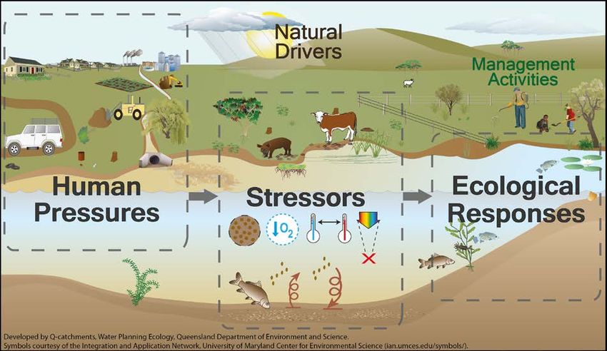
3.2 Selecting priority environmental assets and ecological functions
In the Queensland context, priority environmental assets and priority ecological functions as
defined in section 8.49(1) (b) of the Basin Plan, align with the ecological assets and functions from the
Ecological Risk Assessment Reports for the Border Rivers and Moonie (DES, 2018a and DES,
2018b).
Ecological assets may be a species, a group of species, an ecosystem function, an ecosystem, or a
place of natural value. They occur in the plan area, have an aspect(s) of life history or process
requirement critically linked to the flow regime, and are sensitive to the nature of flow regime
alteration relevant to the area of interest. As indicators, ecological assets are chosen to represent all
flow components relevant to water management. Consistent with Basin Plan Part 5, sections 8.49,
8.50, and 8.51, ecological assets used in Queensland’s environmental assessments are identified
based on the best available science, collectively have dependencies across all flow components, and
have environmental watering requirements which can be expressed in terms of the flow facets in
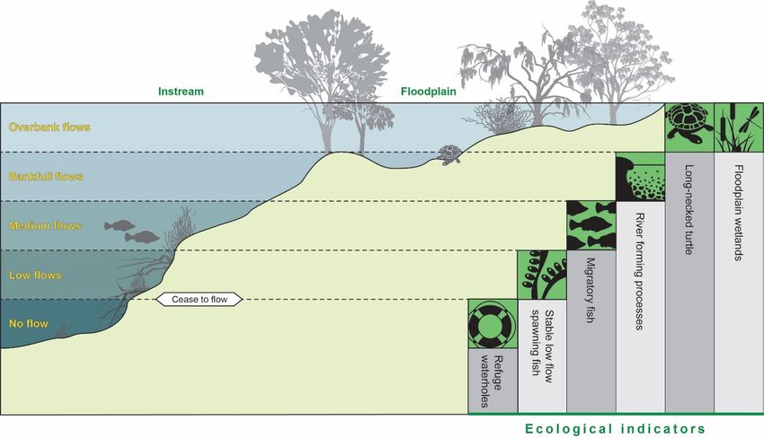
section Basin Plan 8.51 (b) (Figure 3).
Queensland’s priorities for environmental watering are embodied in the environmental outcomes
stated in the Water Plan. While the outcomes generally do not relate to discrete, place-based assets
able to be watered by making releases from storages, they are considered to be high-value
ecosystem components that should be supported over the long-term.
The priority surface water environmental assets and ecological functions (as well as the surface water
flow regimes they represent) are shown in Table 3 (refer Table 1 of the Ecological Risk Assessment
Report for the Border Rivers and Moonie (DES, 20188a and DES, 20188b)).
For more information on this environmental assessment process, refer to the Ecological Risk
Assessment Reports for the Border Rivers and Moonie (DES, 2018a and DES, 2018b). For
information about how the environmental assets were selected, refer to the Asset Selection Report for
the Border Rivers and Moonie (DNRME, 2017a and DNRME, 2017b).
Long-term watering plan for the Border Rivers and Moonie water plan area, Department of Natural Resources,
Mines and Energy. 2019 13Figure 3. Examples of ecological assets and their links to different facets of the flow regime
Table 3. Surface water environmental assets or ecological functions in the Border Rivers and Moonie water plan area
Surface water environmental asset
or Surface water flow regime Catchment
ecological function
Stable flow spawning fish Low flows Border Rivers and Moonie
Macintyre River Billabongs Medium flows and high flows Border Rivers
Fluvial geomorphology and river High flows Border Rivers and Moonie
forming processes
Floodplain wetlands High flows and overbank flows Border Rivers and Moonie
Eastern snake-necked turtle (Chelodina No flow and overbank flows Border Rivers and Moonie
longicollis)
Refuge waterholes No flow and low flows Moonie
Flow dependent ecosystems Mean annual flow Border Rivers and Moonie
Section 10 of this document demonstrates how the identification of assets and functions for the
Border Rivers and Moonie water plan area is consistent with the Basin Plan criteria and Basin-wide
environmental watering strategy.
Long-term watering plan for the Border Rivers and Moonie water plan area, Department of Natural Resources,
Mines and Energy. 2019 143.3 Identifying environmental watering requirements, and developing
ecological targets
In Queensland’s Murray–Darling Basin catchments, environmental watering requirements are based
on protecting components of the flow regime, or flow facets, that support the priority ecological assets
and functions. These flow facets (e.g. magnitude, duration, timing, frequency, rate of change) are
developed for each ecological asset from the best available science, and expressed as ecohydrologic
rules. These ecohydrologic rules are used in a modelling framework and applied to a daily flow time
series representing a water resource development scenario to generate a time series of opportunities
for an ecological response. This likelihood data represents the probability of an ecological
asset/indicator experiencing the critical flow conditions, when and where they are needed over the
assessment period. Thresholds of concern (ToC) are defined to represent the frequency of these
flow-opportunities required to protect asset long-term viability. ToCs represent failure points for the
ecological asset and as such can be considered minimum environmental water requirements. The
probability of achieving a desired ecological outcome is directly related to meeting a ToC over time.
Together, ecohydrologic rules and ToCs are an expression of the environmental watering
requirements of ecological assets (Table 4).
Assessment of ecological risk using the ecohydrologic rules and ToCs/environmental watering
requirements considers a range of metrics around the frequency, temporal sequence and spatial
patterns of ecological opportunities, requiring detailed ecological modelling. Performance indicators
and ecological flow objectives, which correspond to ecological targets required under the Basin Plan,
simplify the ecological requirements into single, node-specific metrics representing no increase in
risky periods for each asset (e.g. days between floodplain inundation events at a frequency required
by turtles). They are:
• Performance indicators—statistical measures calculated using a hydrologic model that
establishes a baseline level for a particular component of the flow regime important to an
ecological asset.
• Environmental flow objectives—the allowable limit for the performance indicator that
establishes the extent of change acceptable in that flow component. In other words, the level
of divergence from the natural conditions which will be allowed to occur under the water plan.
Together the performance indicator and environmental flow objective work to protect the
environment’s share of water by assessing the impacts of a change on ecosystems from water
management decisions. When a decision is proposed, the impact on the performance indicators is
calculated to assess the impact of the management decision on the environmental flow objectives.
Potential plan decisions are tested over the long-term using a specific hydrologic computer simulation
period (124 years in the Border Rivers and Moonie catchment). Decisions may include whether to
approve a trade or a change to a water management protocol or operations manual. If a proposed
decision fails to meet the environmental flow objectives specified in the plan, it cannot proceed.
For the purposes of the LTWP, the environmental watering requirements are translated into ecological
targets comprised of the performance indicator and environmental flow objective. Meeting the flow
objectives will ensure that future decisions made under the water plan will protect flow regimes that
contribute to the health of natural ecosystems, and will ensure that the ecological outcomes will be
achieved.
A full list of performance indicators and rationale for the Water Plan are listed in Appendix 4.
Long-term watering plan for the Border Rivers and Moonie water plan area, Department of Natural Resources,
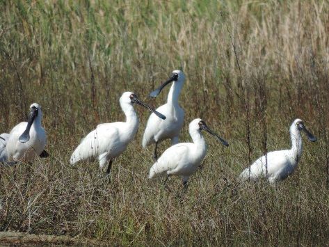
Mines and Energy. 2019 15Waterbirds environmental watering needs
Under the Queensland water planning framework,
the environmental watering needs of waterbirds
are addressed by providing for the watering needs
of important bird breeding habitat. This is
represented by the asset floodplain vegetation
and wetland systems. Further explanation can be
found in Section 4 in the Asset Selection Reports
for the Border Rivers and Moonie (DNRME,
2017e and DNRME 2017f).
Royal spoonbills
Additional water plan measures and rules to achieve environmental
outcomes/ecological objectives
Queensland water plans and other instruments specify rules and strategies to support the delivery of
environmental outcomes/objectives.
Rules for environmental water management are based on knowledge of ecological requirements,
comprised of specific flow management rules in the operations manuals that are designed to achieve
the water plan measures and the intent of the water plan outcomes.
Rules and strategies along with monitoring and reporting requirements are specified in the following:
1. provisions in the water plan
2. measures in the water plan
3. resource operations licences
4. distribution operations licences
5. water management protocols
6. operations manuals.
These include the monitoring of water quality and the impact of storage operations on aquatic
ecosystems and reporting requirements (e.g., annual report, operational report and emergency
report).
Long-term watering plan for the Border Rivers and Moonie water plan area, Department of Natural Resources,
Mines and Energy. 2019 164 Long-term watering plan for the Border Rivers and Moonie water plan area
Table 4. Long-term watering plan for the Border Rivers and Moonie water plan area
Priority environmental asset
ecological functions Environmental Performance indicator & Environmental watering requirement Measures and rules to achieve ecological objectives 7
outcomes/ecological objective environmental flow objective/
Ecological target
Minimise changes to flows of There should be no further Flow thresholds IGA provisions:
Golden Perch 8 water in the plan area increase in the number of days Site-specific mid-channel flow threshold, to • No increase in take above September 2000 level of development
that support fish movement and between fish movement and create connectivity between habitat patches • Access and sharing arrangements for unregulated flows, including commence
fish recruitment dispersal flow events and cease to pump thresholds
Required durations • 25% of unregulated flow left instream as environmental share
Medium flows Any • Operation of the Newinga Regulator and Boomi diversion
Performance indicator:
Required timings Overarching water plan strategies and rules:
Total number of days in spells of September to May to correspond with warm • Decisions must not increase water take
more than 4 years between fish water temperatures • Decisions must be consistent with the environmental flow objectives which
movement events, expressed as cover a range of flow components from no flow to floodplain inundation.
a percentage of the simulation Required frequencies • Monitoring and reporting requirements
period. A fish movement event is Every 4 years to give most individuals an
when a flow exceeds the opportunity for migration and potential Water Plan measures:
estimated mid channel flow spawning within their lifetime
• To require the measurement of take by surface water allocations, as well as
between September and May. relevant overland flow water to a standard set by the chief executive by 31
Maximum period between flow events
Environmental flow objective: December 2022.
10 years – representing the lifespan of golden
• To require the development of a detailed monitoring, evaluation and reporting
The performance indicator does perch in the region
strategy by 1 July 2020 to inform assessment of the water plan’s performance
not exceed what it was prior to
against stated outcomes over time.
commencement of the plan (i.e.
• To require the annual publication of determinations of the environmental share
number of days is no greater
of waterharvesting announcements.
than 100% of the total number of
days in the simulation period).
Additional rules and strategies:
• Releases to provide for environmental flows – Macintyre Brook Water Supply
Scheme (refer to table 8, section 4.1)
• Monitoring and reporting rule – Monitoring the impact of storages on aquatic
ecosystems (Callandoon Water Supply Board and Yambocully Water Board)
(refer to table 10, section 4.1)
Explanatory note for how ecological objectives are met
Fish undertake movement throughout the system for a variety of reasons including finding optimal habitat and breeding. Large-scale movement is often inhibited by
instream barriers which only drown out at bank full flows. It is important, however, to provide movement opportunities within these constrained river reaches at
timescales relevant to the survival and reproduction of these fish. In the Border Rivers and Moonie catchments, the relevant timescale is 4 years between fish
movement events that will result in connectivity between reaches. Return frequencies are based on a large fish age database for the Queensland Murray-Darling
catchments.
The environmental flow objective and performance indicator work together to ensure that water management decisions do not lead to a further increase in the number
of days between fish movement and dispersal events. This ensures that decisions do not impact on medium flows that are required to maintain fish movement and
support resilient populations.
Additional rules and measures also work to support fish movement and achieve the ecological objective, including by providing for releases from Macintyre Brook
Water Supply Scheme to support fish movement.
7Proposed measure and rules to support the water plan which are subject to change upon finalisation of the water plan and supporting documents
8Through the environmental risk assessment process migratory fish were identified as an environmental asset however there was insufficient knowledge to model golden perch as an indicator in the Border Rivers and Moonie catchments.
This asset will be prioritised for further research in this catchment however in the interim environmental watering consistent with that provided for the asset in the Condamine Balonne water plan area has been included in the plan. Golden
perch have also been included in this LTWP for consistency with other Queensland MDB catchments.
Long-term watering plan for the Border Rivers and Moonie water plan area, Department of Natural Resources, Mines and Energy. 2019 17Priority environmental asset
ecological functions Environmental Performance indicator & Environmental watering requirement Measures and rules to achieve ecological objectives 7
outcomes/ecological objective environmental flow objective/
Ecological target
Maintain and, if possible, There should be no further Flow threshold IGA provisions:
Fluvial
improve flows of water to decrease in the frequency or • No increase in take above September 2000 level of development
geomorphology and Site specific bankfull flow threshold
which this plan applies that duration of bank full flow events • Access and sharing arrangements for unregulated flows, including commence
river forming support river channels; and and cease to pump thresholds
processes (Border Required duration
river-forming processes High flows • 25% of unregulated flow left instream as environmental share
Rivers and Moonie)
Performance indicator:
Duration of bankfull flow events under pre- • Operation of the Newinga Regulator and Boomi diversion
development
The total number of days flow is Overarching water plan strategies and rules:
greater than the bank full Required timing • Decisions must not increase water take
discharge expressed as a
Any • Decisions must be consistent with the environmental flow objectives which
percentage of the total number
of days in the simulation period. cover a range of flow components from no flow to floodplain inundation.
Required frequency • Monitoring and reporting requirements
Environmental flow objective:
Frequency of bankfull flow events under pre-
The performance indicator does development Water Plan measures:
not exceed what it was prior to • To require the measurement of take by surface water allocations, as well as
commencement of the plan (i.e. Maximum period between flow events relevant overland flow water to a standard set by the chief executive by 31
number of days is no greater December 2022.
Not specified • To require the development of a detailed monitoring, evaluation and reporting
than 100% of the total number of
days in the simulation period) strategy by 1 July 2020 to inform assessment of the water plan’s performance
against stated outcomes over time.
• To require the annual publication of determinations of the environmental share
of waterharvesting announcements.
Additional rules and strategies
• Change in rate of release – Macintyre Brook Water Supply Scheme (refer to
table 7, section 4.1)
• Releases to provide for environmental flows – Macintyre Brook Water Supply
Scheme (refer to table 8, section 4.1)
• Monitoring and reporting rule – Monitoring the impact of storages on aquatic
ecosystems (Callandoon Water Supply Board and Yambocully Water Board
(refer to table 10, section 4.1)
Explanatory note for how ecological objectives are met
Flows with sufficient shear are required to maintain pools, riffles, waterhole depth and waterhole persistence by scouring out bed material. These flows also support
ecosystem health by transporting nutrients and sediments to downstream reaches. The minimum velocity to initiate transportation of bed material occurs at
approximately bank full discharge. To provide for processes such as sediment movement through erosion, transport and deposition within the watercourse, there
should be no further reduction in the frequency or duration of high flow (bankfull discharge volume) events.
The environmental flow objective and performance indicator work together to ensure that water management decisions do not lead to a further reduction in the number
of days of bankfull flow events. This ensures that decisions do not impact on high flows that are required to support river channels and river forming processes.
Additional rules and measures also work to support river channel maintenance and scouring of waterholes. For example, the change in rate of release rule requires that
Macintyre Brook Water Supply Scheme operators minimise changes to the rate of release from storages, to avoid extreme water level fluctuations.
Floodplain Maintain and, if possible, Floodplain Wetland IGA provisions:
wetlands improve flows of water to There should be no further Flow threshold • No increase in take above September 2000 level of development
which this plan applies that increase in the duration of Site specific wetland inundation flow • Access and sharing arrangements for unregulated flows, including commence
support floodplain extended periods between the thresholds. and cease to pump thresholds
ecosystems within and high flow events. • 25% of unregulated flow left instream as environmental share
Eastern snake- downstream of the plan area, Required duration • Operation of the Newinga Regulator and Boomi diversion
necked turtle including— the Macintyre River Site specific duration of wetland inundation
High flows and overbank
(Chelodina floodplain downstream of events under pre-development. Overarching water plan strategies and rules:
flows
longicollis) Goondiwindi; and channel- • Decisions must not increase water take
connected wetlands associated Performance indicator: Required timing
with that Any
Long-term watering plan for the Border Rivers and Moonie water plan area, Department of Natural Resources, Mines and Energy. 2019 18Priority environmental asset
ecological functions Environmental Performance indicator & Environmental watering requirement Measures and rules to achieve ecological objectives 7
outcomes/ecological objective environmental flow objective/
Ecological target
floodplain Total number of days flow is less • Decisions must be consistent with the environmental flow objectives which
Macintyre River than ‘floodplain reach Required frequency cover a range of flow components from no flow to floodplain inundation.
Billabongs commence to fill discharge' for Site specific frequency of wetland inundation • Monitoring and reporting requirements
(Border Rivers) spells greater than 4 years and events under pre-development.
7 months expressed as a Water Plan measures:
percentage of the total number Maximum period between flow events • To require the measurement of take by surface water allocations, as well as
of days in the simulation period. Site specific maximum periods between relevant overland flow water to a standard set by the chief executive by 31
wetland inundation events under pre- December 2022.
Environmental flow objective:
The performance indicator at
development. • To require the development of a detailed monitoring, evaluation and reporting
each node does not exceed strategy by 1 July 2020 to inform assessment of the water plan’s performance
Eastern Snake-necked turtle against stated outcomes over time.
what it was prior to
Flow threshold • To require the annual publication of determinations of the environmental share
commencement of the plan (i.e.
Site specific wetland inundation flow threshold. of waterharvesting announcements.
number of days is no greater
than 100% of the total number of
Required duration
days in the simulation period)
Any. Wetland filing is assumed to be achieved
once wetland inundation threshold is reached.
Required timing
Any
Required frequency
Site specific. Return frequency to prevent
wetlands being dry for > 7 months.
Maximum period between flow events
4 years
Macintyre Billabongs
Flow threshold
65 CTF thresholds applied to simulated flows
at Macintyre River at Goondiwindi (416201A)
Required duration
Any
Required timing
Any
Required frequency
Site specific frequency of billabong inundation
events under pre-development
Maximum period between flow events
Not specified
Explanatory note for how ecological objectives are met
Floodplain wetlands support several ecological and hydrological functions including nursery habitat for birds, fish and turtles, flood mitigation, erosion control and
sediment trapping. To sustain floodplain biota and communities and protect their productivity in arid and semi-arid areas, there should be no further reduction in the
frequency of high flows that provide lateral connectivity and inundate floodplains, or no further increase in the duration of extended periods between these high flows.
The environmental flow objective and performance indicator work together to ensure that water management decisions do not lead to a further reduction in the
frequency of high flows and no further increase in the duration of periods between high flows. This requirement is achieved by ensuring the number of days in spells of
greater than 4 years and 7 months where flows are below a flow threshold that would inundatefloodplain wetlands does not exceed a specified limit.
Long-term watering plan for the Border Rivers and Moonie water plan area, Department of Natural Resources, Mines and Energy. 2019 19Priority environmental asset
ecological functions Environmental Performance indicator & Environmental watering requirement Measures and rules to achieve ecological objectives 7
outcomes/ecological objective environmental flow objective/
Ecological target
These critical thresholds also satisfy the hydraulic requirements of the eastern snake necked turtle. The turtle needs wetland inundation flows to get out on the
floodplains to feed, breed and aestivate. The turtles can aestivate for up to 7 months, then they return to waterholes when the floodplains dry. Body condition and
breeding success declines during aestivation and residence in waterholes and research has shown that significant impacts occurif they have to inhabit waterholes for
periods greater than four years. Therefore, 7 months + 4 years results has been used as the recurrence requirement for both floodplain wetlands and turtles.
Maintain and, if possible, There should be no further Flow threshold IGA provisions:
Refuge improve flows of water to increase in the length of > 1 ML/day • No increase in take above September 2000 level of development
waterholes which this plan applies that extended dry periods between • Access and sharing arrangements for unregulated flows, including commence
(Moonie) support— flow events that fill waterholes Required duration and cease to pump thresholds
waterholes as refugia Any • 25% of unregulated flow left instream as environmental share
No flows and low flows • Operation of the Newinga Regulator and Boomi diversion
Required timing
Performance indicator: Any Overarching water plan strategies and rules:
The total number of days when • Decisions must not increase water take
Required frequency • Decisions must be consistent with the environmental flow objectives which
flow is below the no-flow
Waterhole dependent. Return frequency to cover a range of flow components from no flow to floodplain inundation.
threshold (5ML/day) for spells prevent waterhole reaching a depth of < 0.5
greater than the waterhole • Monitoring and reporting requirements
metres.
persistence time at the node
(e.g. 0.9-1.5 years), expressed Water Plan measures:
Maximum period between flow events
as a percentage of the total • To require the measurement of take by surface water allocations, as well as
Waterhole dependent. Should not exceed the
number of days in the simulation relevant overland flow water to a standard set by the chief executive by 31
persistence time of the waterhole to a depth of
period. December 2022.
0.5 metres.
• To require the development of a detailed monitoring, evaluation and reporting
Environmental flow objective:
strategy by 1 July 2020 to inform assessment of the water plan’s performance
The performance indicator does against stated outcomes over time.
not exceed what it was prior to • To require the annual publication of determinations of the environmental share
commencement of the plan (i.e. of waterharvesting announcements.
number of days is no greater
than 100% of the total number of Additional rules and strategies:
days in the simulation period) • Releases to provide for environmental flows – Macintyre Brook Water Supply
Scheme (refer to table 8, section 4.1)
• Waterhole management – Macintyre Brook Water Supply Scheme (refer to
table 9, section 4.1)
• Monitoring and reporting rule – Monitoring the impact of storages on aquatic
ecosystems (Callandoon Water Supply Board and Yambocully Water Board
(refer to table 10, section 4.1)
• Change of location for allocations with nil passing flow condition (refer to table
11, section 4.1)
Explanatory note for how ecological objectives are met
Waterholes play a vital role in many ephemeral river systems, acting as drought refuges that allow aquatic organisms (such as eastern snake-necked turtles) to survive
no-flow periods and limited surface water availability. The persistence of high-quality waterhole habitats for the duration of no-flow spells and reconnection to other
waterholes during subsequent flows are essential in maintaining viable aquatic populations.
The environmental flow objective and performance indicator work together to ensure that water management decisions do not lead to a further increase in the total
length of extended dry periods between flow events that fill waterholes. This ensures that decisions do not impact on flows required to maintain waterholes.
Additional rules and measures also work to support waterholes and achieve the ecological objective. For example, the change of location rule for water allocations
prevents water allocations with a nil flow condition from being able to relocate onto a waterhole and draw it down.
Relates to all environmental There should be further IGA provisions:
Flow
outcomes reduction in the mean annual • No increase in take above September 2000 level of development
dependant flow • Access and sharing arrangements for unregulated flows, including commence
ecosystems and cease to pump thresholds
Performance indicator: • 25% of unregulated flow left instream as environmental share
• Operation of the Newinga Regulator and Boomi diversion
Long-term watering plan for the Border Rivers and Moonie water plan area, Department of Natural Resources, Mines and Energy. 2019 20You can also read