Sowing Seeds of Interdisciplinary Work': Relict Plants at Medieval Castles - Dr Karen Dempsey - Funded by the Castle Studies Trust
←
→
Page content transcription
If your browser does not render page correctly, please read the page content below
‘Sowing Seeds of Interdisciplinary Work’:
    Relict Plants at Medieval Castles
        Funded by the Castle Studies Trust

           Dr Karen Dempsey
               NUI Galway, Archaeology

                kdempsey@nuigalway.ie

                                             1
Table of Contents

  Acknowledgements ............................................................................................................................ 3

  Figures................................................................................................................................................ 4

  Introduction, background and aims.................................................................................................... 5

  Relict Plants and Medieval Castles .................................................................................................... 6

  Survey methodology and case-study sites ......................................................................................... 7

  Project Activities ................................................................................................................................ 8

  Adare, Co. Limerick ........................................................................................................................ 10

  Castlecarra, Co. Mayo...................................................................................................................... 15

  Carbury, Co. Kildare ........................................................................................................................ 20

  Castleroche, Co. Louth .................................................................................................................... 28

  Project Reflections and Future Research Directions: ...................................................................... 34

  Bibliography .................................................................................................................................... 38

  Appendix I List of Archaeophytes from the case-study sites .......................................................... 45

  Appendix II Botanical Surveys by Dr Fiona MacGowan ................................................................ 47

                                                                                                                                                         2
Acknowledgements

This research was generously funded by the Castle Studies Trust. Their support enabled new ideas to
emerge and for novel research questions to be addressed. As an early career researcher being awarded
a grant to undertake potentially interpretatively risky work is a wonderful opportunity. I have
benefitted enormously from being supported to widen - even further – the multidisciplinary approaches
of castle studies.

During the final stages of the report writing feedback was received from two assessors, their insights
and helpful commentary improved this report.

Thanks to the Office of Public Work who facilitated access to Adare, Co. Limerick and to all of the
landowners who kindly gave access to the other remaining sites.

                                                                                                    3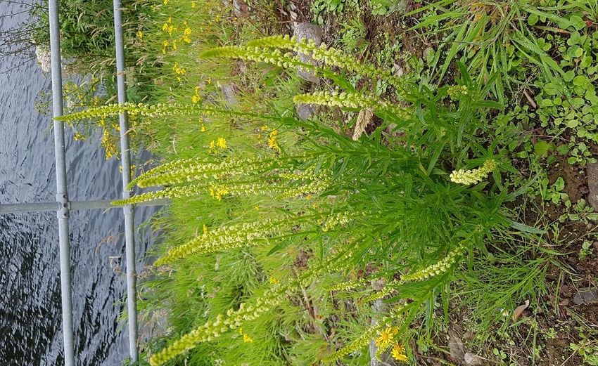
Figures
Figure 1 Distribution of case-study sites in Ireland ............................................................................... 5
Figure 2 Adare Castle, looking west from the bridge over the River Maigue ..................................... 10
Figure        3      Down          Survey          Map        1656-8,          showing           detail       of      Adare,         Co.       Limerick.
http://downsurvey.tcd.ie/down-survey-maps.php ................................................................................ 11
Figure 4 Adare Castle Plan, garden inset and location map (afer O'Keeffe 2015, 209) ...................... 12
Figure 5 Weld (Reseda luteola) adjacent to the castle on the banks of the River Maigue .................. 13
Figure 6 Adare medieval church and graveyard with potential proprietary chapel in foreground ...... 14
Figure 7 Castlecarra, Co. Mayo from the south-east. Image of chamber, latrine and later enclosing
masonry wall ........................................................................................................................................ 15
Figure 8 Looking north-east from Burriscarra Friary towards the parish church ................................ 16
Figure 9 Ordnance Survey Map 1925, Castlecarra to lower left and historic home including
outbuildings and gardens centrally placed. https://maps.archaeology.ie/HistoricEnvironment/ ......... 17
Figure 10 Wood sorrel (Oxalis acetosella) at Castlecarra, Co. Mayo ................................................. 18
Figure 11 Carbury Castle, Co. Kildare, facing north-east. Motte to left, masonry chamber placed
centrally with later additions and 16th century houses with chimneys to right. Earthworks visible in
foreground. ........................................................................................................................................... 20
Figure 12 Carbury Castle (centre top), aerial image showing very clear earthwork and garden features
to south, east and north-east http://map.geohive.ie/ ............................................................................. 21
Figure 13 Interior of masonry chamber block facing east. Large putlogs holes plus thick masonry walls
places this castle in the early thirteenth-century .................................................................................. 22
Figure 14 Colley Estate Map by Michael Byrn featuring Carbury Castle with some indication of
geometric garden (NLI Ms 9212) ........................................................................................................ 23
Figure 15 Carbury Castle interior, facing north-east with abundant vegetation growth visible. Hemlock
inset ...................................................................................................................................................... 24
Figure 16 Distribution of White stonecrop (Sedum album) ................................................................ 26
Figure 17 Carbury Castle in background with Hedge mustard (Sisymbrium officinale) and Comfrey
(Symphytum officinale) to fore ........................................................................................................... 27
Figure 18 Distribution of and Comfrey (Symphytum officinale) left and Hedge mustard (Sisymbrium
officinale) right .................................................................................................................................... 27
Figure 19 Castleroche, Co. Louth. View east across flat plateau ........................................................ 28
Figure 20 Castleroche, Co. Louth from southwest .............................................................................. 29
Figure 21 Castleroche Aerial Imagery http://map.geohive.ie/ ............................................................. 30
Figure 22 Distribution of Hemlock (Conium maculatum), left and Mallow (Malva sylvestris), right 31
Figure 23 Distribution of Milk thistle (Silybum marianum) in Ireland and Britain ............................ 32

                                                                                                                                                             4
Introduction, background and aims
‘Sowing Seeds of Interdisciplinary Work’, the project funded by the Castle Studies Trust, aims to
expand further the multidisciplinary approach of castles studies by including botanical surveys of
castle landscapes. Specifically, this approach comprises relict plant studies which involves the
examination of present-day landscapes for the occurrence of plants that are non-native or rare to that
particular location or region and absent from suitable surrounding terrain (Connolly 1994; Solberg et
al 2013). They are understood be ‘ancestral plants’, descendants of those introduced and/or cultivated
by people in the past (Connolly 1994). Relict plants are often located in isolated stands, typically on
masonry walls and adjacent areas of historic sites (Connolly 1994; Pearman 2008; Preston et al 2004).
Of particular interest for this project are non-native species, known as archaeophytes, which were
introduced pre-1500 AD (Preston et al 2002; Pearson 2007; Williamson et al 2008).

Relict plants studies are slowly becoming established as a novel way to gain insights into past
cultivation practices, medicinal and dietary concerns (Synott 1979; Connolly 1994; Solberg et al, 2013;
Persson 2014; Farstadvoll 2018). Together with detailed analysis of archaeological, historical and
architectural details of these castles, there is great potential for relict plants studies to enrich our
understanding of the ‘green’ lives of people in the past. In order to develop this study area further for
medieval archaeology, four geographically diverse but culturally similar medieval castles were
selected for botanical surveys: Adare. Co. Limerick, Castleroche, Co. Louth, Carbury, Co. Kildare and
Castlecarra, Co. Mayo (Figure 1). This project intended to seek out the botanical legacy of the castle
and its inhabitants, to ascertain if particular plants in the present-day landscape could be associated
with the castle, its possible gardens and the people who lived there.

                                                       Figure 1 Distribution of case-study sites in Ireland

                                                                                                              5
Relict Plants and Medieval Castles
Identification of non-native species of plants was a popular activity during the Victorian era in Ireland
and Britain but its popularity waned over the course of the twentieth century. In the early twenty-first
century, this research area was re-invigorated and botanical studies endeavoured to define and refine
the contributing factors that lead to a plant being considered native or non-native. This included debates
about the recently applied term ‘archaeophyte’ (Williamson et al 2008; Pearman 2008). While there
are still ongoing discussions as to what plants can be understood as archaeophytes, there is now a
general consensus that at least 96 plants were introduced to Ireland pre-1500 (Preston et al 2002;
Williamson et al 2008). Of course, it can be very difficult to establish exactly when these introduction
dates occurred. It may be that many of these archaeophytes were introduced very early on in prehistory.
For now, of note for this project, are introductions of plants which may be linked to medicinal practices
that were shared across networks of new religious or settler-colonial communities who arrived in
Ireland and Britain from the eleventh and twelfth century (Lyons 2015; Synott 1979).

Present ecologies at castles can still reflect past land uses (Creighton 2009, 16). Across Europe, castles
and historic towns are a recurrent focus for studies of relict plants. Research on the Manz and Harz
regions in Germany (Dehnman-Schutz 2004; Brandes 1996) identified a greater number of alien or
non-native species at castles than in comparison to the surrounding areas. Research at West Slavic
settlements and castles produced similar results (Celka 2011). Studies of relict plants in Britain
(Connolly 1994) and Ireland (Synott 1979; MacGowan 2015; Foley 2016) if less extensive have
produced similar results. Botanical observations during the 1920s at Askeaton Castle, Co. Limerick
noted the presence of ‘doubtfully native’ specimen such as Hemlock (Malva sylvestris) and Milkthistle
(Silybum marianum) (Praeger 1900). During the 1970s, Dr Donall Synott (1979), former Director of
the National Botanical Gardens, compiled a list of ten medicinal or culinary herbs which he noted as
regularly occurring at historic sites including Castleroche, Co. Louth and Dunamase, Co. Laois. He
noted that it was likely these species were originally introduced or that the knowledge of their culinary
or medicinal application was brought to Ireland by the Normans. This list included native and non-
native species such as Hemlock (Conium maculatum) which were present at some of the sites included
in this project.

Particularly relevant for ‘Sowing Seeds’, are the results from a large-scale survey of fifty Welsh
monastic and castle complexes completed by ecologist Ann Connolly (1994) which revealed that
certain native and non-native plants with known medicinal properties occur frequently at these sites
on walls or in adjacent areas (see Dempsey 2021, 270 for compiled table; Connolly 1994). She argued
that their prevalence coupled with a notable absence from apparently suitable surrounding terrain
suggest their deliberation curation or cultivation by medieval people living or working at castle or

                                                                                                        6
monastic complexes. More recently, a smaller scale survey was carried out at Bective Abbey to reveal
the botanical legacy of this important Cistercian foundation in Co. Meath established c. 1160. Here,
archaeophytes were found to be much more common along the roadside verges close to the monastic
complex and in townlands where there were grange farms than in control areas unlikely to have been
associated with medieval settlement (Foley 2016). As part of a community heritage project at Lea
Castle, Co. Laois, an ecological survey conducted by ecologist Dr Fiona MacGowan (who carried out
the surveys for ‘Sowing Seeds’) revealed the presence of two notable archaeophytes: greater celandine
(Chelidonium majus) and yellow wallflower (Erysimum cheiri) as well as the conspicuous presence of
navelwort (Umbilicus rupestris) which does not usually occur in this area (MacGowan 2015). There
is growing appreciation of the extra layers of understanding botanical surveys can bring to
archaeological narratives (Dempsey 2021).

Pioneering work employing archaeological approaches has to relict plants studies have been completed
on medieval monastic gardens in Norway (Åsen 2009) and Iceland (Kristjánsdóttir et al. 2014), as well
as historic homes and towns in Sweden (Farstadvoll 2018; Heimdahl 2018) and the Faroe Islands
(Christiansen & Fosaa 2009). This innovative work across the Nordic countries has demonstrated that
relict plants are a key resource in understanding the past but also are an important and overlooked
aspect of green heritage (Åsen 2009; Solberg et al, 2013; Persson 2014; Farstadvoll 2018). Sowing
Seeds aims to demonstrate the relevance of relict plants to castle studies through analysis of four case-
study sites and create a methodology for future studies in medieval archaeology.

Survey methodology and case-study sites
Dr Fiona MacGowan was commissioned to undertake the botanical surveys which were carried out at
four sites during May and June 2020. The scale of each survey varied from 2 to 8 hectares. The
recording process involved the identification of plants at each site, photographing notable samples and
the subsequent compilation of reports which detailed the findings. These reports are found in Appendix
II which is downloadable as a separate pdf. In this report, the archaeological, architectural and
historical profile of each site are discussed along with the notable findings from the botanical surveys.
To place the findings of the botanical surveys in context, plant distribution maps created by the
Botanical Society of Britain and Ireland are used. These are helpful but they imply larger coverage of
records which are only accurate to 1km or 10km grid level.

The case-study sites comprised high-status castles: Adare. Co. Limerick, Castleroche, Co. Louth,
Carbury, Co. Kildare and Castlecarra, Co. Mayo. Initially Mocollop Castle, Co. Waterford was
selected for study but owing to safety concerns, Carbury, Co. Kildare was chosen as a replacement.
These castles, apart from Adare, Co. Limerick, all remain relatively understudied. Adare has been
subject to archaeological investigation; the final report includes an extensive history of the castle and

                                                                                                       7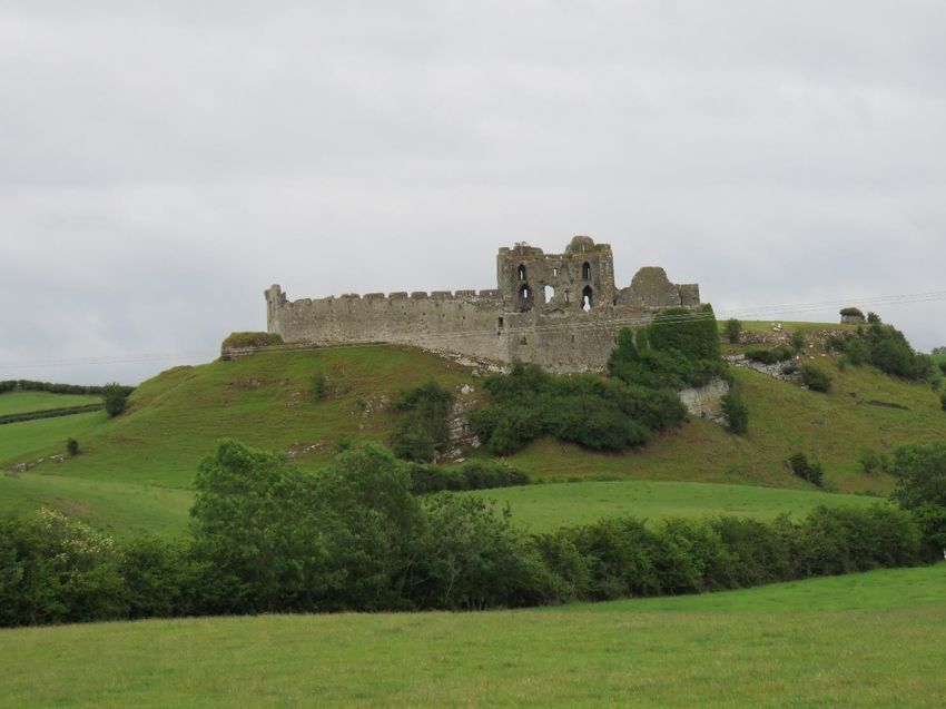
archaeobotanical analysis (Dunne & Kiely 2013). Recent and up-to-date histories or architectural
descriptions have not been published for Carbury or Castlecarra; Castleroche has been the subject of
an architectural history previously published in the Castle Studies Journal (O’Keeffe 2015). All four
have associated settlements and parish churches or religious houses. All sites mentioned within this
report have a corresponding Site and Monuments Number as per the Historic Environment register
compiled by The Archaeological Survey of Ireland (ASI) e.g. Adare Castle (LI021-032003-). These
site         reference        are           searchable       on       the        associated       webpage:
https://maps.archaeology.ie/HistoricEnvironment/

‘Sowing Seeds’ employs traditional castle research methodologies where historical documents such as
annals (e.g., Annals of the Four Masters), court records, inquisition extents and chancery letters from
Ireland are used to deepen understanding of the histories of the case-study sites. Drawing on more
wide-ranging historic sources, contemporary medicinal texts, area used to highlight how medieval
people may have viewed particular plants in terms of health practices. This includes historic sources
such as the Trota collection which contains a book on women’s health and was also translated into
Irish (Green 2002; Färber 2012). Further sources such as the Materia Medica of Tadhg Ó Cuinn from
1415 which was a compendium of international medical texts for an Irish audience (Färber 2019/20)
and the Physicians of Myddvai collection, who where hereditary physicians who practiced within the
royal Welsh court (Pughe 1861) and the early modern Culpepper’s Herbal, are all part of this analysis.
Attention is also given to the folklore around cures, remedies and practices (Allen & Hatfield 2004).
Most attention is given to archaeophytes but of course, many native plants, had medicinal uses from
oral solutions and poultices to more sympathetic practices.

Project Activities
Throughout the project I was keen to share news with various audiences. In May 2020, I wrote a blog
for    the    Castle     Studies    Trust     http://castlestudiestrust.org/blog/2020/05/05/sowing-seeds-of-
interdisciplinary-work-relict-plants-at-medieval-castles/ which outlined my emerging ideas relating to
relict plant studies as well as the planned site visits and various outreach activities. This was widely
read with 241 views from 212 people with a dwell time of over four minutes (Richard Nevell pers.
comm.). It is one of the most read blog posts for the Castle Studies Trust indicating that this subject
area is appealing to a wider interested audience. During fieldwork, aside from the typical
archaeological and architectural research, I made a series of videos that I shared via threads on Twitter
with pertinent information on each castle site. Some of these were very successful with more than
1,000 engagements, they were widely shared, and viewed over 100 times. These threads and tweets
can still be viewed at my @karrycrow Twitter handle.

                                                                                                          8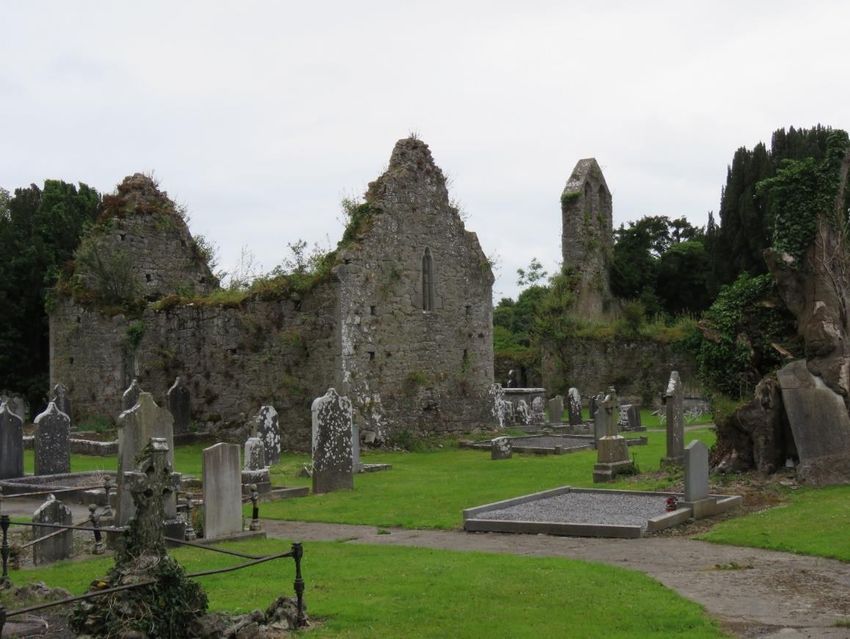
I had planned public engagement activities, but unfortunately these did not happen as anticipated
owing to the pandemic. Instead of the planned walking castle and plant tour at Castlecarra, I completed
a virtual talk for Heritage Week 2020 in Ireland ‘Plants, people and places: medieval castles and
modern landscapes’. This comprised preliminary results, contextual information about medieval
castles and gardens as well as virtual tours from our site visits. So far it has received 224+ views and
can be viewed at https://www.youtube.com/watch?v=HoqxcUee1lE&feature=youtu.be. I also gave a
second talk on the project for the Natural and Cultural Heritage Seminar Series at NUI Galway, Ireland.
This is a well-attended annual series of public talks and my paper ‘Green Lives at Medieval Castles’
had    over    80    attendees.      It   was   recorded   and    is    available   to   view         online:
https://nuigalway.mediaspace.kaltura.com/media/Spring+Lunchtime+Series+2021+Karen+Dempsey
/1_88n0bwr7/211424143. The final talk I gave related to the project finding was for Heritage Week
2021 for the Carlow Historical and Archaeological Society. This focused on castle gardens and how
the methodology for ‘Sowing Seeds’ could be harnessed for citizen science by communities to explore
relict plants at their local historic sites. It was recorded and is available to watch here:
https://www.youtube.com/watch?v=QV9jMNm1de0

In August 2021, for Heritage Week, I spoke with a journalist (Clodagh Finn) about Roesia de Verdun
and Castleroche, Co. Louth as well as the findings from the Castle Studies Trust survey. This was
featured      in    the      Irish        Examiner,    a     national     newspaper          in       Ireland
https://www.irishexaminer.com/opinion/columnists/arid-40361537.html           Subsequently,       I      was
interviewed for national radio (NewsTalkFM) in relation to the same findings. This is available here:
https://www.newstalk.com/podcasts/highlights-from-moncrieff/irelands-female-castle-builder

Dr Fiona MacGowan gave a talk to the Botanical Society of Britain and Ireland in March 2021 about
the project ‘Can botany provide a window to our medieval past?’ which can be viewed here:
https://www.youtube.com/watch?v=5VfNbZnmXsE These talks have sparked much interest and both
Fiona and I have received many enquiries in relation to the project. Working collaboratively with
county Heritage Officers, Fiona is in discussion to create an informative booklet that can be circulated
within community groups who might be interested in pursuing botanical surveys at local heritage sites.

A collaborative peer-reviewed paper ‘Planting new ideas: relict plants at medieval castles in Ireland’
is in preparation and will be submitted to Journal of Medieval Archaeology by November 2021. I am
in the process of writing a blog of our final report for the Castle Studies Trust website.

                                                                                                           9
Adare, Co. Limerick
The castle complex of Adare, Co. Limerick is situated on the northern banks of the River Maigue
(Figure 2), just outside the present-day town. Traces of the medieval town have been revealed in
excavations including an possible outer enclosure and burgage plots, all of which are located on the
south side of the River Maigue, south of the castle (Purcell 2019). This corresponds with historical
sources which record a grant of murage to the town in 1310 (CIRCLE, CR 4, Edw. II, 9). The location
of this later medieval town is supported by antiquarian accounts and later mapping (Figure 3). This
grant also documented a range of goods on which customs were to be paid demonstrating that Adare
was a lively market town and well provided with supplies from hides, textiles and dyes to kitchen
appliances and fresh fish.

Figure 2 Adare Castle, looking west from the bridge over the River Maigue

The town of Adare contains a range of upstanding religious buildings of archaeological interest whose
date spans the later middle ages. The earliest religious house, is a Trinitarian Abbey (LI021-032008-),
and while it is not certain it is believed to have been built by Geoffrey de Marisco (d. 1245) before
1226 (Gwynn & Hadcock 1970, 217). An Augustinian Friary, located south-east of the castle, on the
south side of the River Maigue, was founded by John FitzThomas FitzGerald, 1st earl of Kildare,
before 1316 (Gwynn & Hadcock 1970, 295; CIRCLE PR 11 Edward II, 61). During the fifteenth
century, a Franciscan Friary (LI021-032007) was established by Thomas Fitzmaurice Fitzgerald

                                                                                                    10
(d.1477/8) and Johanna Fitzgerald (d. 1486). All of whom were closely associated with the castle.
Close to the castle itself, c. 75m to the north-east lies a medieval parish church ruins (LI021-032004-)
dedicated to St. Nicholas and situated within an active graveyard which also has a possible medieval
chapel (LI021-032011-) in central position. This particular building is potentially the proprietary
chapel of the seigneurial family who occupied Adare Castle.
Figure 3 Down Survey Map 1656-8, showing detail of Adare, Co. Limerick. http://downsurvey.tcd.ie/down-survey-maps.php
Adare Castle (LI021-032003-) is a National monument in State Ownership No. 622 and has been
subject to antiquarian restoration as well as twentieth-century repairs and conservation. As revealed
during excavations, Adare Castle was constructed on a pre-Norman power centre from which the castle
emerged as a large D-shaped earthwork with a surrounding large ditch and river-fed moat (Dunne &
Kiely 2013). This later formed the inner ward, which was further enclosed by an external wall to the
north-west with a single mural tower and a gatehouse to the south (Figure 4). The outer court is
enclosed by masonry walling which is augmented by a ditch to the north and west. A pre-Norman
seigneurial hall as well as thirteenth-century aisled hall with services and a kitchen flank the River
Maigue which runs along the southern boundary of the castle. This river was navigable from the
Atlantic coast to c. 500m from the castle.
A contemporary historical account from the Book of Munster revealed Domhnall Mór ua Briain, King
of Thomond (d. 1194), as the patron of the early castle. Adare later became the caput of the Geraldines,
11a dynastic Anglo-Norman family. While the earliest historical reference to the Anglo-Norman manor
at Adare was in 1226 AD, this related to a grant to hold an annual fair, but there are no explicit
references at this point to the masonry castle (CDI ii, 214). The status, and upkeep of the castle and
town ebbed and flowed throughout the later medieval period. In 1344 the King granted an unknown
sum of money for the repair of the castle and building (CIRCLE, CR 8 Edward III, 8). During the later
fourteenth century, the town had been burned and damaged and in 1377, Maurice fitz Thomas, Earl of
Kildare (d. 1390) successfully petitioned King Edward III (d.1377) that taxies and levies from the
townspeople be redirected to fund the reconstruction of the town (CIRCLE CR 51 Edward III, 70).
The castle was repaired, renovated and inhabited throughout its life up until at least the sixteenth
century when it experienced another period of intense occupations as revealed in the archaeological
excavation (Dunne & Kiely 2013)
Figure 4 Adare Castle Plan, garden inset and location map (afer O'Keeffe 2015, 209)
During conservation works, parts of the castle deemed at-risk were excavated (Dunne & Kiely 2013).
This included archaeobotanical investigations which explored twenty-three different contexts
revealing plant remains from charred and waterlogged contexts. Charred plant remains tend to be
composed of crop processing waste or burnt refuse and therefore might include material brought into
the site from the fields as arable weeds, thatching and hay. It may also include vegetation growing
within the site that has been cleared or accidentally included in fires. At Adare, charred grains including
oat and wheat were revealed, which formed key parts of the daily diet of the castle inhabitants (Dillon
& Brewer 2013, 207- 224). Unsurprisingly, sedge, used in flooring was also very common.
Waterlogged material is more likely to include vegetation which was growing on site and dropped
12leaves or seeds into the wetter parts of the site such as the areas of the castle moat or wells. This could
also include domestic waste include garderobe/latrine waste. Dill (cf Anethum graveolens) was
discovered in waterlogged contexts from within the castle moat and from the well, it is common in
rubbish pits and latrines in Britain (Greig 1991, 325). Both its seeds and leaves are used for flavouring
foods. It has wide ranging medicinal qualities and can be used fresh, as a poultice or a drink when its
boiled and left to infuse in wine (Culpepper 1653, 154).
A broad range of native flowering plants such as docks, buttercups and orache were found as well as
thistles (Sonchus oleraceus) and Herb robert (Geranium robertanium). Present in the sample but less
common, were nettle (Urtica dioica), selfheal (Prunella vulgaris), broad-leaved plantain (Plantago
major) and bedstraw (Galium verum). They are common within medieval plants assemblages more
generally. These plants typically occur in grassland habitats of (mostly) disturbed ground taxa. They
have numerous uses from floor covering to wholesome medicinal infusions and poultices. All of these
native plants still occur at the castle today.
A number of archaeophytes (William et al 2008)
were present in the excavated assemblage such as
Black mustard (Basssica nigra/rapa), Greater
burdock (Articum lappa) and Hemlock (Conium
maculatum) but none of these were found in the
botanical assemblage at the present-day castle.
Hawkweed (Hieracum spp.) was detected in the
archaeological plant remains and Hawkweed
(Hieracum neosparsum) was identified at the
present-day castle. Unfortunately, Dr Fiona Mac
Gowan recorded that this particular plant is a modern
invasive species as a garden escapee. Weld (Reseda
luteola) was identified at the castle complex along
the bank of the River Maigue (Figure 5). This
archaeophyte is typically common within plant
remains at historic sites and is a recognised dyeplant
most used to give a bright colourfast yellow dye
(Tomlinson 1986; Dickinson 1996). However, it is
Figure 5 Weld (Reseda luteola) adjacent to the castle on the only present at Adare in relict form. No traditional
banks of the River Maigue
dyeplants were found in the archaeological
excavation though historical records (CIRCLE PR 4 Edward II, 9) tells us that people at Adare were
interested in dyes and dyed textiles. As part of the murage grant for Adare town c. 1326, certain
13customs were granted on merchandise coming to the town for sale: and noted was “from each 100 of
verdigris or other, of whatever colour, 2d” and “from each entire English cloth of whatever colour,
2d”. These things imply an interest in trading dye and buying cloth in multiple colours. Perhaps the
absence of archaeobotanical evidence for dye plants at the castle indicates that the craft of dyeing and
the plants used was not a concern for castle residents.
Figure 6 Adare medieval church and graveyard with potential proprietary chapel in foreground
As part of the Adare survey, the adjacent medieval parish church, (proprietary?) chapel and graveyard
were included (Figure 6). These buildings are likely to have been associated with the castle and are
located less than 100 metres to the north. Today, the castle and churchyard are separated by part of a
golf-course. The results from this survey revealed no archaeophytes but the building, and surrounding
areas were more species rich.
Overall, the results from Adare were very disappointing. The walls are completely clean and there is
noticeable pesticide use around the moats of the castle, and even along the river bank. Green lawns do
not promote biodiversity, they are a species poor mono-crop which does not reflect the past lives of
the castle. During the twentieth century, in conservation and heritage management there was an
emphasis on pristine landscapes, manicured lawns and paths. However, this is changing (Emerick
2014; Smith 2008). But, for now, it seems that these conservation ethics and resultant land
management practices have greatly impacted on plant life at the castle.
14Castlecarra, Co. Mayo
Castle Carra is a complex and multi-period castle site (MA100-08200) and is a National Monument in
State Care (No. 222). It is situated on the eastern shore of Lough Carra, in Co. Galway on a heavily-
wooded promontory which is now part of a large farm. Traversing the neck of the promontory is an
intermittent masonry and earthwork feature which may pre-date or be contemporary with the castle
(MA100-082005-). The castle now comprises a large three-storey focal building set within very
compact enclosure (MA100-082006-) which is a later, potentially fifteenth-century addition (Figure
7). This enclosing wall contains one D-shaped mural tower (4.5 diameter) in the north-east corner, and
two opposing entrances in the middle of the east and west walls. The relatively plain wall reaches up
to 2.5m thick in places and has a deep batter which is particularly pronounced at the northern end.
Figure 7 Castlecarra, Co. Mayo from the south-east. Image of chamber, latrine and later enclosing masonry wall
The focal building of the castle is a rectangular block (10.5m x 15m) built of roughly-coursed
limestone over a prominent base-batter on an E-W axis which was augmented at some point in the
castle’s life. The castle is raised on a rock-cut plinth and the western side is partially rock-hewn. It is
likely that this castle was originally two-stories with the later addition of an extra floor which
necessitated the addition of gabled roof. The castle no longer has crenellations; however, just below
the uppermost section of the walls rows of drip stones remain.
15Castle Carra was the caput of the barony of ‘Kerre’ which was awarded to Adam de Staunton, Lord of
Moone Co. Kildare by Richard de Burgh (d. 1242/3) (Orpen iii, 215). At least five castles were
constructed in the barony of ‘Cera’ and surrounding territories by the ‘barons’ who crossed into
Connacht as recorded in the Irish Annals (ALC, 349). The cantred or possibly castle of ‘Cera’ was
mentioned in relation to battles with Ua Chonchair and other Irish dynastic families (ALC 295, 331,
379). The AFM record the construction of a castle at Carra in 1238.
Burriscarra, the associated deserted medieval settlement, is situated c.1.15km directly north-east of the
castle. Here, there are some earthworks and linear features that are likely to represent the vill including
an enclosure (MA100-040). There are records of ‘Buirgés chinntrachta’ as early as 1247 AD when
the settlement was burned, but evidently was rebuilt as in 1307 the ‘Nova Villa de Kera’ is valued in
the Papal Taxation accounts (CDI v, Pap. Tax., 232). Almost certainly this refers to the settlement of
Burriscarra, which was most likely the medieval borough of the cantred. Adjacent to these remains,
but now divided by a modern road, is a thirteenth or fourteenth century parish church (MA100-040001)
with an active graveyard. The Annals of Tuam record Stauntons as still being associated with the parish
church in 1449 (Lateran Regesta 453A: 1449). West of the parish church (c. 30m) is Burriscarra Friary
(Figure 8). This was initially established as a Carmelite House c. 1298 but, it was later transferred to
the Augustinian friars of Ballinrobe (Gywn & Hadcock 1988, 277). Adam de Staunton was recorded
as the patron of Burriscarra Abbey c.1298 but this must be the son or grandson of the original grantee
(Gwynn & Hadcock 1970, 296-7). Adam de Staunton died in 1300 and we must presume that he was
a descendant of the first Adam de Staunton (ALC, 523).
Figure 8 Looking
north-east from
Burriscarra
Friary towards
the parish church
16The de Staunton family continue to be associated with the castle and settlement until the fifteenth
century. At the time of the Down Survey1 the castle and religious house are recorded on the edge of
the lake. Subsequent to this, the castle and the settlement of Burriscarra was confiscated from the
Stauntons and granted to Sir Henry Lynch after the Restoration whose family held it until the
nineteenth century (Gwynn and Hadcock 1970, 296-7). The Lynch family are responsible for the
construction of an early modern house and landscaped parkland adjacent to the castle including the
creation of a tree-lined avenue which comprised the unusual hornbeam trees noted by Dr MacGowan
in her report (Figure 9). By 1844 the house, outbuilding and grounds were described as "now almost
ruins" (see ‘Landed Estates Database’).
Figure 9 Ordnance Survey Map 1925, Castlecarra to lower left and historic home including outbuildings and
gardens centrally placed. https://maps.archaeology.ie/HistoricEnvironment/
While much conservation work has been undertaken at Castlecarra, it has not been excavated. It is
included in the Lough Mask and Lough Carra Special Area of Conservation (Site code 001774) and
the present-day woodland, adjacent to the castle, has the potential to be long-lived. These features
indicated its potential as a case-study site. The associated deserted medieval settlement and religious
house also provided potential comparative sites. Despite these promising attributes, no archaeophytes
were found at the castle. Unfortunately, the Apple tree (Malus domestica) found, understood as an
archaeophyte by Williamson et al 2008, is likely to have grown from a present-day discarded apple
core as noted by Dr MacGowan. But for future work that encompasses a broader chronological span,
the re-ordering of the landscape in the later sixteenth and seventeenth centuries left a significant
1
The Down Survey was undertaken between 1656-1658. It was a detailed national survey to measure all the land to be
forfeited by the Catholic Irish in order to facilitate its redistribution after the victory of the English Commonwealth,
commanded by Oliver Cromwell
17botanical legacy at Castlecarra with the introduction of large trees including Field maple (Acer
campestre), Sycamore (Acer pseudoplatanus) and Hornbeam (Carpinus betulus) some of which are
listed in a document created by Peter Lynch of Castlecarra in 1768 (NAI, CS/CP/ID/51/62, pp.2, 142).
Available here: http://loughcarra.org/wp-content/uploads/2017/05/trees_peter_lynch.pdf
Figure 10 Wood sorrel (Oxalis acetosella) at Castlecarra, Co. Mayo
What is notable then, is the absence of archaeophytes at Castlecarra. Not one of a possible 96 non-
native species introduced pre-1500 occurs at this castle or within the wider landscape. Even widespread
species such as Ground-elder (Aegopodium podagraria) were absent. Is this unusual? As Castlecarra
was the last site surveyed in this project it is possible that a long dry April and May in 2020 affected
flowering species which were no longer identifiable in June. Perhaps the wetter colder climate of
western Ireland is less suitable to certain plants. Present-day land management may also have led to
declines in certain species. Historic interventions in the areas surrounding the castle and later house
could also play a role in their absence. It is also possible that the people who lived at Castlecarra in the
medieval period did not curtate non-native species and different plants were used in medicinal and
health practices. For example, wood sorrel (Oxalis acetosella) (Figure 10), only occurring at
Castlecarra, was noted in Ó Cuinn’s 1415 herbal as a cure for fever when consumed as drink with a
number of other herbs (Färber 2012, 91). While archaeophytes were absent, three neophytes were
noted, indicating that imported plants can indeed be curated at the castle. Native plants such as Selfheal
18(Prunella vulgaris), Meadowsweet (Filipendula ulmaria) and Lady’s bedstraw (Galium verum) were
present. These were widely used in the medieval period for medicinal and culinary purposes, so we
must not assume that those living as Castlecarra were not in tune with the medicinal qualities of the
plants in their own green world. Indeed, these plants occur at all four of the castles, and while these
are relatively widely spread across the Irish landscape, they are notable for their uses in medieval daily
life. Nevertheless, the complete lack of archaeophytes at Castlecarra requires greater investigation. In
the future, further ecological surveys with multiple visits should be undertaken to ensure seasonally
variable plants are captured in the survey. In tandem with this, pending proper permissions, it would
be of great interest to carry out systematic coring to reveal paleoenvironmental data. The landscape of
Castlecarra particularly lends itself to this, and with the comparative site at Burriscarra, this future
programme of research would address some of these issues.
19Carbury, Co. Kildare
Carbury Castle set on Carbury Hill where it overlooks the surrounding landscape and the small village
of Derrinturn, in north Co. Kildare. This multi-period castle comprised a motte (KD008-001001-), a
thirteenth-century masonry castle (KD008-001002-) comprising a two-storey chamber block to which
later, potentially fifteenth and sixteenth centuries additions (KD008-001003-) to the north and north-
east were made (Figure 11). This complex culminated in a further three-storeyed expansion to the
south-east of the castle which is crowned by cut-stone star-shaped chimneys. Surrounding the castle
south and eastern side are likely early modern landscaped gardens (KD008-001004) that add to the
complexity of the site, but which could be earlier (Figure 12). The northern section of the hill, to the
rear of the castle has been subject to quarrying and the castle now sits on a precipice overlooking
boglands to the north. A ruined medieval church (KD008-001005-) and graveyard (KD008-001006-),
are located c. 80m south of the castle complex.
Figure 11 Carbury
Castle, Co. Kildare,
facing north-east.
Motte to left,
masonry chamber
placed centrally with
later additions and
16th century houses
with chimneys to
right. Earthworks
visible in
foreground.
Carbury Castle has a long and complicated history, it features regularly in historic sources from
medieval and early modern Ireland. The larger territory of Carbury is named in the Song of Dermot
and the Earl, a Norman French poem created during the thirteenth century focussing on the story of
Richard de Clare in Ireland. Giraldus Cambrensis also documents this land division in his Expugnatio
Hibernica. In 1170, Richard de Clare sub-infeudated the lands of Leinster to his barons and he granted
20the lands of Carbury to Meiler fitz Henry (d. 1220), grandson of King Henry I (d. 1135) and Nest ferch
Rhys (d. 1158). Meiler was later to become the Lord Chief Justice of Ireland. Given the early date that
Meiler held Carbury, it is likely that he constructed the earthwork and timber castle at Carbury (Otway-
Ruthen 1959, 183).
Figure 12 Carbury Castle (centre top), aerial image showing very clear earthwork and garden features to south, east and north-east
http://map.geohive.ie/
In 1203 the lands passed to William Marshall (d. 1219) through marriage to Isabel de Clare (d. 1219).
After some time, Meiler fitz Henry relinquished the lands to William and Isabel. It is possible that the
earliest masonry castle can be attributed to the married couple, perhaps constructed during 1208-1213
when Marshall was in Ireland (CDI i, 56). The first specific mention of a castle was by Henry III (d.
1272) when he ordered Hugh de Lacy, First Earl of Ulster (d. 1242) to return the castle of Carbury to
Gilbert Marshall (d. 1241) which had been seized from his father –William – during a dispute with the
King (CDI i, 322). It seems possible that if the castle had been taken from William Marshall, and the
chamber block appears to date to the very early thirteenth-century then it was likely constructed under
his and Isabel de Clare’s patronage (Figure 13).
The Marshall inheritance and subsequent division of Leinster is well-known (Otway-Ruthven 1961,
163-81). From the mid-thirteenth century onwards Carbury passed through many hands which
undoubtedly shaped the castles’ architecture. In 1249 Margaret Countess of Lincoln (d.1270) received
21the castles of Kildare and Carbury as part of her dower (CDI i, 446). On her death the lands were split
and Carbury was inherited by Agnes de Vescy (d. 1290), grand-daughter of Marshall. By 1297, they
have reverted to King on the death of William de Vescy (d. 1297), son of Agnes who had served as
Justiciar of Ireland for three years from 1290 AD (Waugh 2005). The de Vescy inheritance reverted to
the king on the death of William in 1297 (Waugh 2005).
Figure 13 Interior of masonry chamber block facing east. Large putlogs holes plus thick masonry walls places this castle in the early
thirteenth-century
At some point subsequent to this, Carbury becomes part of the de Bermingham landholdings. They
were a family associated with Leinster (Offelan) from at least the last quarter of the twelfth century.
In 1305 Peter de Bermingham was responsible for the murder of a dozen chief men of the O'Connors
of Offaly at Carbury (CJRI 1305-7, p. 82). In 1317 Carbury was demised to John Mohun by Edward
II for an annual rent of £100. It was subsequently transferred to John de Wogun (CPR 1317–21, 43;
CPR 1309–13, 122–3). When William de Bermingham was hanged at Dublin Castle 1 July 1332, by
order of Anthony Lucy, the Justiciar of Ireland, Carbury was back in the hands of the de Berminghams.
(see Connolly 1995 for an account of his attempted escape from Dublin Castle). Walter de
Bermingham, William’s son, eventually regained favour and in return for his services in battle King
Edward III restored lands to him in 1356. But prior to this, in 1354, James de Bermingham and
22entourage assaulted and killed. Simon Betagh, a sheriff, and imprisoned his stewards at Carbury (CPR,
1354-58, p381). In 1360, Walter dies leaving his estates to his sister Margaret de Bermingham (d.
1361). Margaret died shortly afterwards and Carbury passed to her husband Robert Preston, who was
the Chief Baron of the Exchequer. In 1368 the de Berminghams imprisoned not only the sheriff of
Meath but also the Chancellor of Ireland at Carbury. Unrest continues and in 1374 Robert Tyrell,
formerly keeper of the peace in Co. Dublin was captured and imprisoned there until a ransom was paid
(CIRCLE CR 48, Edward III, 85). The castle must have been returned to the de Berminghams, as in
1447, they dismantled the castle, apparently to prevent it falling into the hands of crown supporters.
However quite soon after the Lord Deputy of Ireland, Sir John Talbot, sent a company of soldiers to
rebuild it and defend the land against the O’Connors and de Berminghams (Salter 2004, 46).
Figure 14 Colley Estate Map by Michael Byrn featuring Carbury Castle with some indication of geometric garden (NLI Ms 9212)
In 1538, Walter Colley, Principal Solicitor for Ireland, leased the castle for an initial twenty-one year
period. The lease was renewed twice until 1569 when his grandson Henry received the manor and
castle at Carbury in a grant from the crown. It is possible that Henry Colley restored the older parts of
the castle and added a front section in Elizabethan style (Dempsey 2007). The tall, star-shaped cut-
stone chimneys, that tower above the castle date to this period and appear to confirm this theory. In
1719, the castle is the property of Henry Colley, the great, grandson of Walter Colley. When Henry
23passed away in 1723 he left the castle and estates to his two daughters: Elizabeth and Mary Colley
(Robinson 1991, 90). In 1744, the heiresses employed Mr. Michael Byrn to survey their estate. Byrn
describes the castle as being in need of much repair but with great potential; he also praises the castle
and its grounds deeming both to be fit for ladies and gentleman (Holton 2004, 99-100; Figure 14). A
map made for this survey shows the wider landscape layout of Carbury Castle in the eighteenth century
and geometric gardens, while of course this does not reveal the medieval castle it could indicate where
the favourable location for a garden may have been (Figure 12).
Clearly, Carbury has a long and very well documented history from the medieval and up to the early-
modern period. While at first this appears to be very tumultuous with raids, different occupations,
kidnappings and burnings seemingly common, in reality, these events were largely concentrated in the
fourteenth century. For most of the late medieval period the castle seems to have been held by the
crown but tended to or lived in by a series of stewards e.g. William Wellesley in 1382 (Patent Roll 5
Richard II, 135 - 10 Mar. 1382) or in 1387 Walter son of James Delahide was appointed as keeper of
that castle (CIRCLE PR 10 Richard II, 175 - 30 Mar. 1387). This series of stewards is hard to reconcile
as the architecture of the castle suggests that building was ongoing during this period. In keeping with
wider cultural traditions of castle life across Europe it would be expected that Carbury would have
gardens of various sorts from orchards, herb gardens and vegetable patches to the more ornamental
enclosed spaces. The people living and working at the castle would certainly have eaten the produce
from gardens but was it grown at Carbury? Did the early castle – the iteration of the twelfth and
thirteenth century - have a garden? Historic maps and present-day aerial imagery certainly indicate the
presence of gardens. These earthwork features including terracing and a sunken garden are visible at
ground level (Figure 12). However, their date is uncertain; they must date – at least – to the Renaissance
period when the Elizabethan extension to the south was constructed. There is a strong possibility that
these gardens were laid over those that already existed at the castle. Perhaps also possible is the
presence of a smaller garden, McNeill (1989/90, 61) noted that at some point the top of the motte was
surrounded by a wall to form a courtyard – could this space have been an enclosed garden?
It was hoped that the relict plants survey might provide another route towards addressing how medieval
people interacted with the green spaces of the castle. However, at Carbury, the landscape of the castle
complex is very grazed. The interior of the castle is somewhat more inaccessible to animals and
contains a much broader range of plants. Three archaeophytes were revealed here: White stonecrop
(Sedum album), Hedge mustard (Sisymbrium officinale) and Hemlock (Conium maculatum). This final
plant is abundant within its interior space. It has been revealed during castle excavations across Ireland
and Britain including at Adare, Co. Limerick as we saw earlier.
24Hemlock contains the chemical compound ‘coniine’ which is well known for its toxicity. It is
incredibly poisonous, and dangerous to humans and livestock (Lopez et al 1999; Hotti & Rischer
2017). Despite these concerns, this particular plant is incredibly versatile and widely used in medieval
medicinal practice and present-day medicine is increasingly turning towards its utility as a non-
addictive painkiller (Hotti & Rischer 2017). Hemlock was featured in the compendium of medieval
medical texts known as the Trotula which was in part written by Trota of Salerno. In the book on the
Diseases of Women, translated by Monica Green, it is used to encourage menstruation:
“Likewise, an excellent powder for provoking the menses: take some yellow flag, hemlock, castoreum,
mugwort, sea wormwood, myrrh, common centaury, sage. Let a powder be made and let her be given
to drink one dram of this with water in which savin and myrrh are cooked and let her drink this in the
bath. And let her be given one dose of one scruple” (Green 2002, 77)
But is also has uses for bladder complaints
“We place cooked watercress on the pubic area, and we put the patient in a decoction of the same
[herb].Women, indeed, labor from this same affliction, for whom we make a fumigation of horsemint,
catmint, and pennyroyal. For both men and women we should make a steambath, and place them in
water in which juniper, catmint, fleabane and horsemint, laurel leaves, pennyroyal, wormwood, [and]
mugwort have been boiled, and in the bath we give [to them] uncompounded hemlock. And thus the
patient is freed even if s/he has a bladder stone because, so long as it is not yet solidified, patients
purge it through their urine as if little grains of sand were coming out.” (Green 2002, 131).
Figure 15 Carbury Castle interior, facing north-east with abundant vegetation growth visible. Hemlock inset
25The uses of hemlock are also noted in Ó Cuinn’s Materia Medica herbal (Färber 2019/20, 92) who
cautions that the ingestion of seeds can be fatal but that its medical uses are numerous from lactation
suppression to soothing herpes flare-ups and easing pain in diseased joints.
White stonecrop is of interest but not for its
medicinal value. This plant, sometimes known as a
‘house-leek’ a name which is also applied to
navelwort (Devlin 2021; Culpepper 1653, 131). It
was grown on the roofs of houses, presumably
thatch, as it was thought to protect against lightning
strike which may cause fire (Dempsey 2021).
Interesting, the broad category of ‘house leek’ was
also believed to be a remedy for burns and scalds.
The dual use of this plant showcases medieval
understanding of the green world through this
sympathetic practice which can be unpicked through
the material trace of the living plant in present-day
landscapes (Figure 16).
Figure 16 Distribution of White stonecrop (Sedum album)
Hedge mustard, also found with the castle complex,
is from the Brassicaceae family and contains anti-microbial compounds (Blažević et al 2010). It is
known as “the singers’ plant” for its traditional use in treating aphonia, vocal disability and hoarseness
(De Nisi et al, 2021; Zorzan et al 2020). Its chemical composition suggests that it can be effective in
treatment of inflammatory pain and works as a muscle relaxant (Zorzan et al 2020). Perhaps this may
be responsible for its use as a laxative in the medical texts written by the Physicians of Myddvai (Pughe
1861, 358).
No other archaeophytes were located within the masonry castle or adjacent to the castle walls as at
other sites or as recorded by Connolly (1994). However, drawing inspiration from Foley’s 2016
Bective Abbey survey where road verges and hedgerows of the townland (territorial unit) were also
surveyed and one further archaeophyte was revealed at Carbury: Comfrey (Symphytum officinale)
which is relatively uncommon (Figure 17 and Figure 18). Comfrey is particularly notable, known as
knitbone, it was widely used as a healing poultice for broken bones throughout medieval medical texts
(Allen & Hatfield 2004, 208; Färber 2012, 89). Pharmacologically, this plant contains allantoin, which
promotes the creation of new cells and healing of connective tissue (Allen & Hatfield 2004, 208).
26Figure 17 Carbury Castle in background with Hedge mustard (Sisymbrium officinale) and Comfrey (Symphytum officinale) to fore
The survey at Carbury demonstrates the importance of including the wider landscape, hedgerows,
verges and townland boundaries especially given that many show indications of being ancient (Foley
2016). This is a really important methodological development in relict plant studies in Ireland.
Figure 18 Distribution of and Comfrey (Symphytum officinale) left and Hedge mustard (Sisymbrium officinale) right
27Castleroche, Co. Louth
Castleroche (LH003-029001-, National Monument in State Guardianship no 460) is situated on a rocky
outcrop overlooking the flat plains of north Co. Louth (Figure 19 and Figure 20). It was part of the
large territorial holdings of the de Verdun family who histories and Irish estates has been extensively
discussed (Otway-Ruthven 1968; Hagger 2001). The castle commands a prominent position in the
landscape, the curtain walls enclose a sub-triangular area, rising directly from the edge of bedrock on
all but northeast side along which a large twin-towered gatehouse is located. Situated above the gate
passage, the residential chamber once accessed the likely aisled hall situated along the southern side
of the castle complex. Analysis of ownership and research on the historic fabric of the castle (O’Keeffe
2014) indicated it was constructed by Roseia de Verdun in three stages, potentially to an altered plan,
during the early to mid-thirteenth century. However, little is known about what lies within its
immediate environs beyond the hall and possible kitchen which presents as a thick-walled square
building at the western end of the hall but placed centrally within the complex.
Figure 19
Castleroche, Co.
Louth. View east
across flat plateau
On a large plateau to the east of the castle, separated by a wide rock-cut fosse, are the alleged remains
of a possible deserted medieval village (DMV) (L003-029002) (Figure 19). Earthworks in this location
are understood to be indicative of a DMV. A weekly market and annual fair were established here by
1284 AD and a borough is mentioned in 1332 AD (CIRCLE CP Rolls, Richard II, 9). However, in
1332, an inquisition of the lands of Theobald Verdon (d. 1250) record that the “castle of le Roche, in
28which there are no buildings because the castle has been burnt by the Irish so that it is extended at no
value” (CIRCLE CP Rolls, Richard II, 9; Otway-Ruthven 1967, 447-455). Interestingly, for this study,
also recorded was ‘a small plot called parke, and a garden lying around the castle, and 4 acres of
meadow and pasture around the castle.’. In the original Latin transcription, the term ‘gardina’ was used
which implies a plural; therefore, the correct translation should be ‘gardens lying around the castle’.
Typically, the term ‘gardinum’ is used to denote a kitchen garden so it is possible that there were
multiple kitchen gardens in the area around the castle or, perhaps gardens of different kinds (Harvey
1981, 4). Swallow (2020) in her detailed study of Caernarfon Castle argues that the late-thirteenth-
century references to a gardinum at Caernarfon Castle may have referred to “a park-like, plaisance-
type of garden” (2020, 121-139). Caernarfon was a large royal castle, whose patrons had great financial
capacity. But the patron of Castleroche, Roesia de Verdun, was very much part of the royal circle –
King Henry III wrote letters separately to her and her father urging her to marry Theobald de Walter
(Hagger 1998, 62). There is potential then, for the gardinum at Castleroche to refer to a more ornate
garden commensurate with Roesia’s own place in the social elite of the later medieval period.
Figure 20 Castleroche, Co. Louth from southwest
While there seems to be some consensus that the DMV mentioned in the historic sources is located on
the plateau to the east of the castle, I am less sure. Certainly, there are earthworks visible in aerial
29You can also read