Source Water Protection Plan - Roswell Municipal Water System - Roswell-NM.gov
←
→
Page content transcription
If your browser does not render page correctly, please read the page content below
Roswell Municipal Water System

Source Water
Protection Plan
Final Draft
April 2019
Roswell Municipal Water System
                                          #NM3520203
                              SOURCE WATER PROTECTION PLAN
                                          Final Draft 4/12/2019

                                       This plan was prepared by:
 New Mexico Environment Department, Drinking Water Bureau, Source Water Protection Program
                                           in cooperation with
             Roswell Municipal Water System staff, board, and community stakeholders
                                 In follow‐up to the development of the
                            2018 City of Roswell Source Water Assessment

                                       C ONTACTS & R ESOURCES
Roswell Water Production:
Roger Buckley, Water Production Superintendent / 575‐347‐5421 / r.buckley@roswell‐nm.gov
https://www.roswell‐nm.gov/211/Water

New Mexico Environment Department – Drinking Water Bureau – Source Water
Jill Turner, Source Water Protection Program Manager / 505‐476‐8623 / jill.turner@state.nm.us
https://www.env.nm.gov/drinking_water/source‐water‐protection/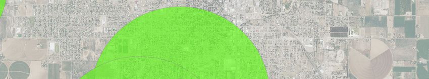
Table of Contents
Executive Summary.......................................................................................................................... ii

1 ‐ Introduction .............................................................................................................................. 1
     1.1 Background ‐ Source Water Protection Assistance for Public Water Systems.................. 1
     1.2 Roswell Source Water Protection ...................................................................................... 2

2 – Source Water Plan Development Process ................................................................................ 2
     2.1 Source Water Planning Stakeholder Participation ............................................................ 3

3 – Water System Facility Information ........................................................................................... 4
     3.1 Emergency & Contingency Planning ................................................................................... 4

4 – Water Production & Source Water Supply ............................................................................... 6
     4.1 Water Production:.............................................................................................................. 6
     4.2 Source Water Supply ‐ Regional Hydrogeology – Roswell Basin Aquifer System.............. 7
     4.3 Regional Source Water Quality .......................................................................................... 9

5 – Source Water Protection Area ................................................................................................ 10

6 ‐ Source Water Assessment and Potential Sources of Contamination (PSOC).......................... 11
     6.1 Inventory of Existing & Potential Contaminants.............................................................. 11
     6.2 Susceptibility Analysis ...................................................................................................... 11

7 – Managing for Source Water Protection .................................................................................. 16
     7.1 Issues of Concern – KNOWN EXISTING Sources of Contamination (SOCs) ...................... 16
     7.2 Issues of Concern ‐ POTENTIAL Sources of Contamination (PSOCs) ‐ Vulnerability
          Scores above 1 ................................................................................................................ 22
     7.3 Issues of Concern ‐ POTENTIAL Sources of Contamination (PSOCs) ‐ Vulnerability
          Scores below 1 ................................................................................................................ 25
     7.4 Issues of Concern – Other ................................................................................................ 27
            Voluntary Remediation Sites identified in 2018 Source Water Assessment .................. 27

8 Source Water Action Items & Priorities .................................................................................... 28

References ...................................................................................................................................... 1

Roswell – Source Water Protection Plan – April 2019, Final Draft                                                                                  i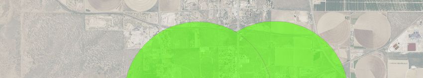
Executive Summary

The City of Roswell is dedicated to protecting the quantity and quality of drinking water for the
Roswell community. Through this Source Water Protection Plan, the City is using the assessment of
its water sources to develop action items and priorities that will help sustain drinking water supplies
for current and future generations.

An initial source water assessment was conducted by the New Mexico Environment Department
(NMED) in 2004. In 2018, the City of Roswell worked with NMED and their contractor Daniel B.
Stephens & Associates to complete an updated, in‐depth assessment of existing and potential
threats to the Roswell Municipal Water System’s supply. The assessment includes a review of the
water system’s facility, water production, source water hydrogeology, water quality, source water
area, and a susceptibility analysis. The source water area was defined for each of the system’s 20
groundwater wells using a fixed‐radius method. Within these areas, existing and potential sources
of contamination were identified and assessed for the level of risk they pose to the water supply.

This source water protection plan provides a summary of the 2018 assessment, descriptions of
identified source water impacts, and a table of actions items to be implemented by the City. The
susceptibility ranking for each well is derived from a calculated sensitivity score (based on the well’s
infrastructure and sensitivity of the aquifer) and a calculated vulnerability score (based on the
likelihood and impact of well contamination and a count of existing or potential sources of
contamination). Susceptibility rankings for the City wells reveal 6 wells with Moderately Low
susceptibility, 4 wells with Moderate susceptibility, 7 wells with Moderately High susceptibility, and
3 wells with High susceptibility.

The primary risks to the water supply come from the following types of existing contamination
sources: leaking underground petroleum storage tanks, the former Walker Air Force Base
contamination plume, the Lea & W. Second Street Superfund Site, and the McGaffey & Main
Superfund Site. Lower risks to the water supply come from these types of potential sources of
contamination: aboveground and underground petroleum storage tanks (not leaking), agricultural
fields, arroyos, auto salvage yards, plugged oil and gas wells, private wells, and septic systems.

Action items identified by the Roswell source water protection team include: hosting a public
forum to present this document and receive public feedback; obtaining more hydrological data on
the upper and lower aquifers and modeling a more accurate capture zone for the City wells; and
developing City zoning ordinances to protect and safeguard City wellfields. It is the intention of the
City to review and update the source water assessment and plan every two years.

Roswell – Source Water Protection Plan – April 2019, Final Draft                                    ii
1 - Introduction
Protecting Your Drinking Water through Source Water Protection Planning

Access to safe, clean drinking water is a right to every citizen in this state and is a key component in
maintaining a healthy and viable community. All drinking water sources are vulnerable to
contamination from a variety of human activities. Without attention to managing these potential
sources of contamination, communities will be faced with increased costs and potential loss of their
drinking water sources. Water sources in New Mexico are also highly vulnerable to depletion
through unsustainable use and drought. Careful planning and monitoring for source water supply is
invaluable.

Applying proactive measures through source water protection planning is less expensive and more
reliable over the long term. If an aquifer that supplies drinking water to a community becomes
contaminated, the cost of restoring clean drinking water costs far more than the costs of water
treatment alone. The underlying principle in Source Water Protection is that prevention is the most
effective and efficient method to assure long‐term safe drinking water.

Source Water Protection Plans (SWPP) go beyond a basic source water assessment to create an
effective management tool with strategies for protecting a community’s source of drinking water.
SWPPs not only provide a source water contaminant inventory and vulnerability assessment, but
include water system and hydrogeologic information, source water area maps, best management
practices, and action items developed by the public water system through a public participation
process.

The purpose of this document is to provide an effective planning tool for Roswell’s Municipal Water
System to protect its source of drinking water. This Source Water Protection Plan has been
developed in coordination with the New Mexico Environment Department (NMED) following
standard guidelines for source water plans developed by the U.S. Environmental Protection Agency
and NMED. The document is designed to provide relevant information that informs sustainable
source water management and that can be easily updated.

1.1 Background ‐ Source Water Protection Assistance for Public Water Systems

U.S. Congress amended the Safe Drinking Water Act in 1996 to provide for the assessment and
protection of sources of public water supply. The U.S. EPA provides guidance and encourages
partnerships for the voluntary process of source water protection planning. States, including New
Mexico completed source water assessments between 2002 and 2006 for all public water systems,
and are now implementing strategies to help local communities use and update the information
obtained from these assessments.

NMED’s Drinking Water Bureau’s, Source Water Protection Program works with individual water
systems, such as Roswell Municipal, with input from the community and other interested parties.

Roswell – Source Water Protection Plan – April 2019, Final Draft                                   1

The program assists in the development of a Source Water Protection Plan that is unique to your
individual system and offer ways to identify potential sources of contamination and other threats to
your drinking water, while designing a plan that will protect your water system.
1.2 Roswell Source Water Protection
Roswell is in Chaves County with a population of 48,600 served by 19,000 service connections.
Roswell provides water to Bottomless Lakes State Park (NM3580103) via a consecutive connection
serving 526 people with 10 service connections. Average daily water production for 2017 was about
11 million gallons.
Roswell’s Goals for Source Water Protection
Preserve the high‐quality drinking water source currently available in the aquifer
Encourage city residents to use city water instead of private wells (properly plug existing
wells
More public education on water issues such as conservation and cross connection.
Provide the public with additional and easier ways to notify the city of potential problems
with the water system.
Preserve a sustainable quantity of water available in the aquifer for future generations
Encourage water conservation practices throughout the city and region
2 – Source Water Plan Development Process
The source water planning process began with an update to the New Mexico Environment
Department, 2004; Source Water Assessment & Protection Program, Report of Roswell Municipal
Water Supply Water Utility, Public Water System #[NM35]20203 (NMED, 2004).
NMED and their contractor, Daniel B. Stephens & Associates (DBS&A) worked with the Roswell
Water Production Department to gather background information for the current system structure
and to identify all potential sources of contamination and other issues of concern for the system’s
wells. The assessment includes a susceptibility analysis on the risk of contamination for the city
wells. The 2018 “Source Water Assessment, City of Roswell, New Mexico (PWS #NM3520203)” is
available from the City of Roswell upon request.
Roswell – Source Water Protection Plan – April 2019, Final Draft 2
When the assessment was completed, the Roswell and NMED members of the assessment
workgroup expanded to include other City staff and outside entities who developed a draft source
water protection plan.

2.1 Source Water Planning Stakeholder Participation

Stakeholder participation is an important part of the source water planning process. Involving a
broad array of local officials, community groups, water professionals, and other interested
community members in the source water protection planning process, Roswell is helping to ensure
the ongoing success of this effort.

Table 1: Source Water Planning Participation

 Stakeholders                                                                                       Workgroups

 Participant           Title                                  Affiliation                        Assessment   SWPP

 Roger Buckley         Water Production Superintendent        City of Roswell                        X           X

 Jesus Talamantes      Water Production Supervisor            City of Roswell                        X           X

 Jill Turner           Program manager                        NMED DWB Source Water                  X           X
                                                              Protection Program

 David Torres          Source Water Protection Specialist     NMED DWB Source Water                  X           X
                                                              Protection Program

 Kelly Baker           Water Planner                          Daniel B. Stephens & Associates        X
                                                              (contractor to NMED‐DWB)

 Jennifer Hill         Senior Engineer                        Daniel B. Stephens & Associates        X
                                                              (contractor to NMED‐DWB)

 Louis Najar           Director of Planning & Engineering     City of Roswell                                    X

 Glenda Allen          Engineering ‐ civil engineering tech   City of Roswell                                    X

 Eric Boyda            Watershed manager                      Village of Ruidoso & Lower Pecos                   X
                                                              River Water Association

 Aron Balok            Superintendent                         PVACD Pecos Valley Artesian                        X
                                                              Conservancy District

(This section to be amended for final document)

Others who participated in the process and provided comments will be acknowledged here.

A public meeting to introduce the source water assessment and protection plan will be held in
spring 2019.

Roswell – Source Water Protection Plan – April 2019, Final Draft                                                 3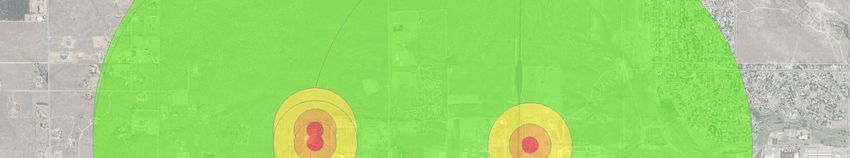
3 – Water System Facility Information
Roswell’s Water Production Department lies within the City’s Public Works.
Water Production employees are located at Central Control. There are 11 employees and their
primary responsibility is the operation and maintenance of the following:
5 reservoirs
4 pressure regulating stations
20 water wells
This facility is operated around the clock and water production and reservoir levels are continuously
monitored.
The City has 26,189 acre feet of water rights available for consumption per year
20,000 acre feet are currently pumped per year
There are 3,888 acre feet of water rights in reserve for future needs
The last source of water rights would be return flow credit for effluent discharged to the Rio
Hondo
The Roswell Municipal Water System consists of the following infrastructure:
20 active production wells
21 treatment plants (disinfection, gaseous chlorination, post)
2 booster stations with a total of 8 booster pumps
steel storage tanks: 3,500,000 gal, 5,000,000 gal, 500,000 gal, and 100,000 gal
2 concrete storage tanks 7,500,000 gal each
Additional information on the Roswell system, including water quality testing data, can be found on
New Mexico Environment Department’s Drinking Water Watch website at:
https://dww.water.net.env.nm.gov/NMDWW/
3.1 Emergency & Contingency Planning
Roswell Water System strives to be prepared for any emergency situation that may arise. There is
an emergency response plan in place that describes the people or organizations, along with their
contact information, that need to be contacted when various situations happen (“City of Roswell,
Central Control, Emergency Response Plan”, 10/15/2018.) There are also emergency backup
generators at our main location and two of our well sites in the event of a power failure.
Roswell – Source Water Protection Plan – April 2019, Final Draft 4
Roswell – Source Water Protection Plan – April 2019, Final Draft 5

4 – Water Production & Source Water Supply

Artesian groundwater provides the source for Roswell’s 20 active wells. The City is very fortunate to
have a quick recharge aquifer with a consistent supply of quality water. Currently there are no
conservation measures in place for consumers due to the ample water supply.

4.1 Water Production:

The Roswell Water System produced an average of 4.23 billion gallons in the period between 2008
and 2017 with the lowest amount (3.74 bg) in 2015 and the highest (4.89 bg) in 2011 (Figure 1).

The amount of water produced annually varies from year to year depending on the amount of
precipitation; over the last 10 years the water system has averaged about 4.2 billion gallons of
water produced annually. The amount of water produced each month follows a typical trend for
the southern New Mexico area with variations on an annual basis (Figure 2).

Figure 1

                               Annual Water Produced 2008 ‐ 2017
                                        (billion gallons)
                                                                                        Average = 4.23
                                           4.89
 5.00
                     4.50                            4.51
 4.50                           4.11                               4.30   4.10
           4.19                                                                                      4.02
 4.00                                                                            3.74       3.91

 3.50

 3.00

 2.50

 2.00

 1.50

 1.00

 0.50

 0.00
           2008      2009       2010      2011       2012          2013   2014   2015       2016     2017

Roswell – Source Water Protection Plan – April 2019, Final Draft                                            6
Figure 2
Monthly Average Water Production 2008‐2017
(million gallons)
600
506 517
500 478
452
393 380
400
321 311
300
250
216 202
201
200
100
0
jan feb mar apr may jun jul aug sep oct nov dec
4.2 Source Water Supply ‐ Regional Hydrogeology – Roswell Basin Aquifer System
The Roswell Basin aquifer system consists of two aquifers: an alluvial aquifer and an underlying
carbonate‐rock aquifer (DBS&A, 2018). The system covers an area of about 2,200 square miles,
extending from just north of Roswell to northwest of Carlsbad, New Mexico. This aquifer is the
most permeable and extensively used aquifer within a larger 12,000‐square mile area of carbonate
rocks that extends from Vaughn, New Mexico to the New Mexico‐Texas border.
The Roswell Basin aquifer system is primarily recharged from infiltration of precipitation in the
unconfined region of the carbonate‐rock aquifer and the overlying unconfined alluvium. Recharge
also stems from surface water in streams and ponds, and irrigation water applied to fields. The
carbonate‐rock aquifer also receives minimal recharge from the alluvial aquifer above through the
leaky confining layer between the two aquifers when the potentiometric surface of the carbonate‐
rock aquifer is lower than the potentiometric surface of the alluvial aquifer. The NM Bureau of
Geology states that “The Roswell Artesian Basin has been described as a world‐class example of a
rechargeable artesian aquifer system” (NMBG; 2018).
Roswell – Source Water Protection Plan – April 2019, Final Draft 7Figure 3: Roswell Artesian Basin (source: NM Bureau of Geology; 2018) In addition to the discharge from wells, the artesian aquifer also discharges to the shallow aquifer, and, in places where the river flows direction on top of the confining beds, directly to the Pecos river via fractures (USGS 1983). Water levels in the San Andres lime‐stone aquifer of the Roswell Artesian Basin fell by as much as 230 ft since being used for irrigation. Due to conservation, levels have rebound in most areas. Between 1975 and 2005 hydraulic head in the artesian aquifer increased by between 10 and 20 feet in the Roswell area. Due to the high transmissivity of the artesian aquifer, pumping results in shallow yet broad cones of depression (NMBG; 2007). Roswell – Source Water Protection Plan – April 2019, Final Draft 8
4.3 Regional Source Water Quality

In the northeastern portion of the carbonate aquifer, concentrations of dissolved sodium and
chloride in the groundwater are rather high. Sodium concentrations range from 1,500 to 3,000
mg/L, and chloride concentrations range from 2,000 to 5,000 mg/L. Total dissolved solids (TDS)
concentrations in this area can range from 7,000 to 12,000 mg/L. In the northern half of the aquifer,
the water is a mixed calcium‐sodium‐sulfate‐chloride type. Sulfate concentrations measured in
1994 from Roswell’s wells showed concentrations from just over 250 ppm to 690 ppm. In the
eastern part of the alluvial aquifer, chloride concentrations can be very high in the water near the
upper or lower parts of the aquifer. The chloride concentration changes with the irrigation
pumping, peaking after irrigation season. The largest seasonal variation in mineral concentrations
occurs in the area between Roswell and the Pecos River (USGS; 1983).

Samples from several Roswell wells including the Kerr wells, were taken as part of a survey of
community water systems for a 1980 report. The samples were taken between 1975 and 1979, with
the exact date unspecified. A comparison of the results from this survey for a few selected analytes
from 3 of the Kerr wells and more recent results is shown in Table 1. This comparison shows a fair
amount of consistency in the concentrations of the selected contaminants for each well between
the two sample periods. Several analytes were found to be below the detection limit for the Kerr
wells in the 1980 Report, including arsenic, mercury, and lead (NMEID, 1980).

Table 2: Kerr Well Water Quality Samples

 Kerr well sample results from the 1980 Chemical Quality Report and 1994

 Well                                    Kerr #1                      Kerr #2                    Kerr #3
 Analyte/Sample date           Pre-1980            1994    Pre-1980             1994   Pre-1980            1994
 Sulfate (mg/l)                  264.3             254        267.6             266      274.1             262
 Fluoride (mg/l)                  0.91             0.9         0.90             0.9       0.93              1
 Nitrate (mg/l)                   1.20             1.1         1.11             1.1       0.84             0.8

Roswell – Source Water Protection Plan – April 2019, Final Draft                                                  9
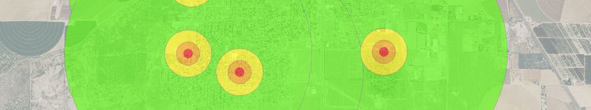
5 – Source Water Protection Area
For the 2018 Roswell Source Water Assessment, source water protection areas for individual wells
of the Roswell PWS were defined using an “arbitrary fixed radii” method resulting in four fixed
radius circular zones extending out to a one‐mile radius (DBS&A, 2018). These are:
Zone A: radius of 0 to 200 feet from the wellhead
Zone B: radius of 200 to 500 feet from the wellhead
Zone C: radius of 500 to 1,000 feet from the wellhead
Zone D: radius of 1,000 to 5,280 feet (1 mile) from the wellhead
These zones and distances are commonly used in source water planning and are intended to
roughly represent time of travel for water within the well capture zone. A more sophisticated
method of delineation can be used in a future phase of source water planning to provide increased
accuracy of the source water area and a well’s capture zone. Choosing a more advanced method
will depend on time, cost, and hydrogeologic data available.
Source Water Protection Area Maps from the 2018 Source Water Assessment are included in the
following pages.
Roswell – Source Water Protection Plan – April 2019, Final Draft 10Bright Sky Rd
Bright Sky
Co Rd 141
Moore Ave
Townsend Trl
Flying H Way
er
ow
S Atoka Loop nh
se
Ei
N Mullis Ave
N
US Hwy 70 Byp
W College Blvd W College Blvd
Co Rd 129
N Moore Ave Moore Ave
Dow Dr
N Brown Rd
Mark Rd
Le Anne Dr
Hamilton Dr
Mullis St
Leslie Ln
Hall Dr
Dogwood Rd Co Rd 155
Saunders Dr
Mullis Ave
Relief Rte
N
Pearson Dr
Mason Dr
N Hall Dr
)HHW
Co Rd 151
Co Rd 154 C1-151
Bahia Dr
r
aD
W 8th St
n
Can
Co Rd 143
dri
Allison Dr
Se
lo n
Dr
Xanadu Rd Co Rd 153 re
onc
Explanation Shink na
ta
Go
lito
le Dr Dr
Avenida de Vista Rd
ito
Ri
Cie
ve
Dr
Estrellita Dr
&LW\ZHOO
rs
Rosebud Rd SMW11
id
eD
Highland Rd
6RXUFHZDWHUSURWHFWLRQDUHD SMW10
r
SMW18
W 4th St
6RXUFHZDWHUSURWHFWLRQDUHD
EXIIHU]RQH
US Hwy 70 380 W 2nd St
Lookout Dr
US Hwy 380 US Hwy 70 W 2nd St
=RQH$
IW
Ransom Rd
Wooldridge-M argaret Rd
6
?352-(&76?10
B10('B':%B&$3B'(9?*,6?526:(//?0;'6?),*85(6?),*B362&6B60:B:(//60;'
=RQH%
IW
Ave B
Cass St W Juniper
Man
W Juniper St
Cass St
S Evergreen Ave
Ave G
=RQH&
IW
Pim a Dr
er Rd
n Av
S Birch Ave
Walnut St
Ave D
e
=RQH'
±IW
Ave C
enhow
t C1-218
Ave A
aS
Avenue E
W Alameda St
Ave F
ed
Foothill Blvd
m
S Pinon Ave
Ale
Carrol Ave
362&V
S Eis
W Hendricks St
Robles A
W Hendricks St
Ave D
$XWRVDOYDJH\DUG
Shepherds Way
C1-220 W Bland St
ve
$67IDFLOLW\ W Bland St
Irene Ave
Cochran St
S Spencer Ave
8QGHUJURXQGVWRUDJHWDQNIDFLOLW\
S Brown Rd
/HDNLQJXQGHUJURXQGVWRUDJHWDQN
Georgia Rd
Co Rd 189
VLWH Oly
mp
ia
6HSWLFV\VWHPLQVRXUFHZDWHU Rd C1-182 Co Rd 182
Co Rd 141
SURWHFWLRQDUHD
US Hwy 285 Byp
W Reed St
:HOOLQ26(GDWDEDVH W Jefferson St
'RPHVWLF Co Rd 185 W McGaffey St
Co Rd 168
2WKHU
C1-190
Thunderbird Ln
5RDG
$UUR\R
526:(//081,&,3$/:$7(56Explanation
&LW\ZHOO
6RXUFHZDWHUSURWHFWLRQDUHD
6RXUFHZDWHUSURWHFWLRQDUHD
EXIIHU]RQH
=RQH$
IW
=RQH%
IW
=RQH&
IW
=RQH'
±IW
362&V
$67IDFLOLW\ McGaffey St
CAP XXX - Main & McGaffey [Former Safeway]
8QGHUJURXQGVWRUDJHWDQNIDFLOLW\
/HDNLQJXQGHUJURXQGVWRUDJHWDQN SRW13
VLWH
/DQGILOOHQWUDQFH
9ROXQWDU\UHPHGLDWLRQVLWH
)DUPHTXLSPHQWVXSSOLHU
Kmart Store #7017
256
)XQHUDOKRPH
+DUGZDUHOXPEHUSDUWVVWRUH SRW17
9HWHULQDU\VXSSO\RUIDFLOLW\ Starlight Drive In Theatre
6HSWLFV\VWHPLQVRXUFHZDWHU
SURWHFWLRQDUHD
*URXQGZDWHUSHUPLW VWDWXV
6
?352-(&76?10
B10('B':%B&$3B'(9?*,6?526:(//?0;'6?),*85(6?),*B362&6B65:B:(//60;'
$FWLYH
Western Dairy Transport
2LODQGJDVZHOOV (015'2&'
2LOSOXJJHG SRW16 SRW12
:HOOLQ26(GDWDEDVH
'RPHVWLF SRW15
0RQLWRULQJ
South Park Cemetery
2WKHU
Main St
5RDG
Atkinson Ave
5DLOURDG
$UUR\R
0F*DIIH\DQG0DLQ*URXQG:DWHU
3OXPH6XSHUIXQG6LWH
*HQHUDOVRXUFHDUHD
3&(7&(SOXPH
/HDDQG:HVW6HFRQG6WUHHW
6XSHUIXQG6LWH
6LWH N
)HHW
6LWH 526:(//081,&,3$/:$7(56N
)HHW
Explanation RW3
RW5
&LW\ZHOO
6RXUFHZDWHUSURWHFWLRQDUHD
6RXUFHZDWHUSURWHFWLRQDUHD
EXIIHU]RQH
RW4 RW1
=RQH$
IW
=RQH%
IW
=RQH&
IW
=RQH'
±IW
:DONHU$)%
362&V
$EDWHPHQWVLWH
6
?352-(&76?10
B10('B':%B&$3B'(9?*,6?526:(//?0;'6?),*85(6?),*B362&6B5:B.:B:(//60;'
ROSWELL
$67IDFLOLW\ INTERNATIONAL
AIR CENTER
8QGHUJURXQGVWRUDJHWDQNIDFLOLW\
6HSWLFV\VWHPLQVRXUFHZDWHU KW5
SURWHFWLRQDUHD
*URXQGZDWHUSHUPLW VWDWXV
KW6
$FWLYH
7HUPLQDWHG
2LODQGJDVZHOOV (015'2&'
2LOSOXJJHG
:HOOLQ26(GDWDEDVH
'RPHVWLF
0RQLWRULQJ
2WKHU
5RDG
5DLOURDG 526:(//081,&,3$/:$7(566
?352-(&76?10
B10('B':%B&$3B'(9?*,6?526:(//?0;'6?),*85(6?),*B362&6B.:B:(//6B6287+0;'
Yo Xing Co Rd 255 Y O Rd
Co Rd 127
Yo Crossing Rd
Co Rd 58
Co Rd 125
Carson City Rd
Yo Rd
Nashville Rd
Co Rd 128 Richmond Rd
KW1
Honolulu Rd
K re
KW2 nze
l Rd
KW3
Co Rd 59
C3-116
Pierre R d KW4
16
d1
oR
Old Y O Crossing Rd
C
Stagecoach Rd
Zubi Draw Rd
Co Rd 13
Sa
l
em
Rd
13
Co
m
Rd
N
N
11
5
)HHW
1$,3DHULDOLPDJHU\
Explanation
362&
&LW\ZHOO
5RDG :HOOLQ26(GDWDEDVH
6RXUFHZDWHUSURWHFWLRQDUHD
$UUR\R 'RPHVWLF
6RXUFHZDWHUSURWHFWLRQDUHDEXIIHU]RQH
6HSWLFV\VWHPLQVRXUFHZDWHUSURWHFWLRQDUHD 2WKHU
=RQH$
IW
2LODQGJDVZHOOV (015'2&'
=RQH%
IW
2LOSOXJJHG
=RQH&
IW 526:(//081,&,3$/:$7(56N TW1 TW2
)HHW
Explanation
6
?352-(&76?10
B10('B':%B&$3B'(9?*,6?526:(//?0;'6?),*85(6?),*B362&6B7:B:(//60;'
&LW\ZHOO
6RXUFHZDWHUSURWHFWLRQDUHD
6RXUFHZDWHUSURWHFWLRQDUHD
EXIIHU]RQH
=RQH$
IW
=RQH%
IW
=RQH&
IW
=RQH'
±IW
362&V
6HSWLFV\VWHPLQVRXUFHZDWHU
SURWHFWLRQDUHD
:HOOLQ26(GDWDEDVH
'RPHVWLF
2WKHU
5RDG
526:(//081,&,3$/:$7(566 - Source Water Assessment and Potential Sources of Contamination (PSOC) The 2018 City of Roswell Source Water Assessment (Assessment) included an inventory of both existing and potential sources of contamination and a susceptibility analysis to determine the threat level of those contaminants to the system (DBS&A, 2018). Chemical contaminants considered are primarily limited to those under the National Primary Drinking Water Regulations with Maximum Contaminant Levels (MCLs) established by EPA. 6.1 Inventory of Existing & Potential Contaminants Potential sources of contamination (PSOCs) are defined as any possible site or event that could, under any circumstance and time frame, lead to contamination of a water system’s sources. Not all sites identified as PSOCs pose the same level of risk. Due to type of PSOC, some sites may pose little to no contamination risk, while others may pose an imminent threat. Sources of contamination (SOCs) are considered those activities which are currently threatening or contaminating the source water. Locations of SOCs and PSOCs for the Roswell system are found on the source water protection area maps of the Assessment. A full list of SOCs and PSOCs for each well are found in Table 6 of the Assessment. The Assessment included all identified existing and potential sources of contamination present in the source water areas for the Roswell city wells. The existing contamination is, so far, restricted to the upper aquifer only and is not known to affect the lower aquifer where the city wells draw their water. The SOCs and PSOCs pose different levels of risk to Roswell’s source water and so require varying levels of management. 6.2 Susceptibility Analysis The susceptibility analysis was developed to determine of risk of contamination for each well. The analysis combines results of a vulnerability assessment and a sensitivity assessment. Roswell – Source Water Protection Plan – April 2019, Final Draft 11
Susceptibility

                   Vulnerability                                        Sensitivity

                                                                 Well              Aquifer
       Severity Score              Count Score
                                                            Infrastructure        Sensitivity

        Vulnerability

        The vulnerability ranking is based on the type and number of PSOCs and SOCs present within
        a well’s SWPA and is calculated as: Severity Score x Count Score = Vulnerability Rank

        The severity score considers both the likelihood of a contamination event due to the type of
        PSOC or SOC, and the contaminant that might impact or has impacted the water source.
        The count is the number of times a given PSOC type occurs per zone. A count score is then
        given to represent the PSOC count range (i.e. counts of 2‐5 = 2; 6‐10 = 3…). This is done so
        that a large number of small sources such as septic tanks could not give such a high score
        and overwhelm all the other factors.

        Severity scores given to each SOC and PSOC in the assessment range from .1 to 5. PSOCs
        were given risk severity scores from 0‐1; SOCs were scored from 2‐5 given their greater
        threat value.

        Sensitivity

        The sensitivity is an evaluation of two components:

             1. well infrastructure (based on the 2002 SW Assessment by NMED)
             2. aquifer sensitivity within a well’s SWPA

Each well’s final susceptibility ranking from the assessment is shown in Table 1 below.

Roswell – Source Water Protection Plan – April 2019, Final Draft                                12
Table 3‐ Final Susceptibility Rank from 2018 Roswell Source Water Assessment
Final Susceptibility Rank by Well
Vulnerability Susceptibility
Well Sensitivity Ranking
Ranking Ranking
City Well #10 (SMW10) Moderate High Moderately high
City Well #11 (SMW11) Moderate High Moderately high
City Well #12 (SRW12) Moderate High Moderately high
City Well #13 (SRW13) Moderately high High High
City Well #15 (SRW15) Moderately high High High
City Well #16 (SRW16) Moderate Moderate Moderate
City Well #17 (SRW17) Moderately high Moderate Moderately high
City Well #18 (SMW18) Moderate Moderately high Moderately high
Riac Well #1 (RW1) Moderate High Moderately high
Riac Well #3 (RW3) Moderately high High High
Riac Well #4 (RW4) Moderate High Moderately high
Riac Well #5 (RW5) Moderate Moderate Moderate
Kerr Well #1 (KW1) Moderate Moderately low Moderate
Kerr Well #2 (KW2) Moderate Low Moderately low
Kerr Well #3 (KW3) Moderately low Moderately low Moderately low
Kerr Well #4 (KW4) Moderate Moderately low Moderate
Kerr Well #5 (KW5) Moderate Low Moderately low
Kerr Well #6 (KW6) Moderate Low Moderately low
Trigg Well #1 (TW1) Moderate Low Moderately low
Trigg Well #2 (TW2) Moderate Low Moderately low
Roswell – Source Water Protection Plan – April 2019, Final Draft 13Table 4 ‐ Contamination Threats with Vulnerability Score of 1 or Higher
PSOC & SOC
Buffer PSOC / Count Severity
Well Name PSOC & SOC Description Count Vulnerability
Zone SOC Score Score
Score
City Well #10 D PSOC AST facility 2 2 0.5 1
City Well #10 D SOC Leaking underground storage
tank 1 1 4 4
City Well #10 D PSOC Private well 194 10 0.2 2
City Well #10 D PSOC Septic system 234 10 0.3 3
City Well #11 D PSOC AST facility 2 2 0.5 1
City Well #11 D SOC Leaking underground storage
tank 1 1 4 4
City Well #11 D PSOC Private well 185 10 0.2 2
City Well #11 C PSOC Septic system 14 4 0.3 1.2
City Well #11 D PSOC Septic system 229 10 0.3 3
City Well #12 D SOC Leaking underground storage
tank 1 1 4 4
City Well #12 C SOC McGaffey and Main Ground
Water Plume Superfund Site 1 1 5 5
City Well #12 D PSOC Septic system 37 5 0.3 1.5
City Well #12 D PSOC Underground storage tank 5 2 0.8 1.6
City Well #12 D SOC Voluntary Remediation Site:
Kmart Store #7017 1 1 3 3
City Well #12 D SOC Voluntary Remediation Site:
Starlight Drive‐In Theater 1 1 3 3
City Well #13 D SOC
Lea and West Second Street
Superfund Site (Sites 1, 3, and
4) 3 2 5 10
City Well #13 D SOC Leaking underground storage
tank 4 2 4 8
City Well #13 D SOC McGaffey and Main Ground
Water Plume Superfund Site 1 1 5 5
City Well #13 D PSOC Private well 153 10 0.2 2
City Well #13 D PSOC Septic system 14 4 0.3 1.2
City Well #13 D PSOC Underground storage tank 6 3 0.8 2.4
City Well #13 D SOC
Voluntary Remediation Site:
CAP XXX Main & McGaffey
[former Safeway] 1 1 3 3
City Well #13 D SOC Voluntary Remediation Site:
Kmart Store #7017 1 1 3 3
City Well #15 D SOC Leaking underground storage
tank 1 1 4 4
City Well #15 D PSOC Private well 89 8 0.2 1.6
City Well #15 D PSOC Septic system 25 5 0.3 1.5
Roswell – Source Water Protection Plan – April 2019, Final Draft 14City Well #15 D PSOC Underground storage tank 4 2 0.8 1.6
City Well #16 D PSOC Private well 89 8 0.2 1.6
City Well #16 D PSOC Septic system 25 5 0.3 1.5
City Well #16 D PSOC Underground storage tank 2 2 0.8 1.6
City Well #17 D PSOC Private well 100 8 0.2 1.6
City Well #17 D PSOC Septic system 20 4 0.3 1.2
City Well #17 D PSOC Underground storage tank 2 2 0.8 1.6
City Well #18 D PSOC AST facility 2 2 0.5 1
City Well #18 D SOC Leaking underground storage
tank 1 1 4 4
City Well #18 D PSOC Private well 236 10 0.2 2
Kerr Well #1 D PSOC Septic system 19 4 0.3 1.2
Kerr Well #4 D PSOC Septic system 11 4 0.3 1.2
Riac Well #1 D SOC Abatement site: Walker Air
Force Base 1 1 4 4
Riac Well #1 D PSOC AST facility 6 3 0.5 1.5
Riac Well #1 D PSOC Private well 52 6 0.2 1.2
Riac Well #1 D PSOC Septic system 256 10 0.3 3
Riac Well #3 D SOC Abatement site: Walker Air
Force Base 1 1 4 4
Riac Well #3 D PSOC AST facility 5 2 0.5 1
Riac Well #3 D PSOC Private well 94 8 0.2 1.6
Riac Well #4 D SOC Abatement site: Walker Air
Force Base 1 1 4 4
Riac Well #4 D PSOC AST facility 6 3 0.5 1.5
Riac Well #4 D PSOC Private well 56 6 0.2 1.2
Riac Well #4 D PSOC Septic system 14 4 0.3 1.2
Riac Well #5 D PSOC AST facility 3 2 0.5 1
Riac Well #5 D PSOC Private well 119 9 0.2 1.8
Riac Well #5 D PSOC Septic system 54 6 0.3 1.8
Roswell – Source Water Protection Plan – April 2019, Final Draft 157 – Managing for Source Water Protection
This section of the Source Water Protection Plan considers the issues of concern and the
recommended management practices, actions, and protection strategies.
All of Roswell’s 20 municipal wells are artesian and have depths of over 300 feet with twelve over
500 feet. This depth, below the confining layer adds a level of protection from contamination
occurring at or near the surface; as such, contamination risk to these wells is reduced. However,
the thickness and structural integrity of the confining layer varies and is not understood in detail
throughout most of the area. A greater understanding of the hydrogeologic connection between
the upper and lower aquifers would greatly increase the ability assess risk of contamination for the
Roswell source water.
7.1 Issues of Concern – KNOWN EXISTING Sources of Contamination (SOCs)
Note: contaminants are expressed in milligrams per liter (mg/L) in order to correspond to
Maximum Contaminant Levels (MCL) for National Primary Drinking Water standards.
Abatement Site: Walker Air Force Base
Vulnerability Scores: 4
Wells & Zones Affected: Riac Wells #1 (all zones), 3, 4 (zone D)
Contaminants of Concern Trichloroethylene (TCE) (MCL = .005 mg/L)
Perchloroethylene (PCE/PERC)
Issue:
The site was operated by the Department of Defense from 1941‐1967. When the Base closed in
1967, a majority of the property was deeded to the city and became Roswell International Air
Center (RIAC). The city has leased the property to various tenants since that time.
TCE contamination was detected in residential wells of the Y‐O subdivision with
investigations of individual areas occurring since 1991. (Ball, 2009)
There are 2‐3 significant TCE plumes. The greatest concentration is found in the upper
aquifer with An abatement plan for the TCE was followed between 1998 – 2003 but was found
ineffective.
There have not been any remediation activities to date.
The US Army Corps of Engineers (USACE) currently administers the site; an initial Work
Plan was submitted to the NMED Ground Water Quality Bureau. Abatement and legal
processes between the City of Roswell, NMED, and USACE are ongoing
Concerns:
Potential contamination of source water (lower aquifer) by current groundwater
contamination plume. The contamination is mostly affecting the upper aquifer, however
there have been instances of deeper wells with traces of contamination, suggesting a
possible connection between the two aquifers.
One of the 4 deep aquifer monitoring wells, DW‐002 had TCE detections in 2003 of
0.0012 mg/L and in 2009 of 0.003 mg/L indicating that there is some amount of
contamination from this site is present in the lower aquifer (Snyder, 2018). Another deep
aquifer well, DW‐004, had a detection of 0 .0014 mg/L in a 2017 sampling event. DW‐002
was plugged after 2009 and so was not sampled in 2017 (EA Engineering, 2018).
RIAC Wells near the site have had detections of both chemicals, but they have been below
the Maximum Contaminant Level (MCLs) of 0.005 mg/L. Regulatory samples taken
between 2008 and 2018 show these varying results for TCE: RIAC #1 at 0.001 ‐ 0.004
mg/L; RIAC #3 at 0.001 ‐ .002 mg/L; and RIAC #4 at 0.001 ‐ .004 mg/L.
Riac Well #1 is within the east‐central plume area – though the well pulls from the deeper
confined aquifer and not from the upper aquifer where the greatest concentration of the
plume is located.
Riac Well #4 is on the edge of the western plume while well #3 is near the edge of the
east‐central plume.
In this source water area, the hydrologic conditions regulating exchange of water
between the two aquifers needs to be better understood.
Strategies:
Coordination with the NMED Ground Water Quality Bureau on remediation activities.
Review reports regarding this site as updates are made available.
Roswell is working to plug some of the monitoring wells on this site that have been
determined by the city as unnecessary.
Roswell – Source Water Protection Plan – April 2019, Final Draft 17Petroleum – Leaking Underground Storage Tank (LUST)
Vulnerability Scores: 4‐8
Wells & Zones Affected: City Wells #10, 11, 12, 13,15,18
Contaminants of Concern Volatile organic compounds such as benzene and synthetic
organic compounds such as ethylene dibromide (EDB)
Issues:
Leaking underground [petroleum] storage tanks (LUST) have been identified in several locations
near City wells. Many are resolved posing no further threat. Four remain under investigation or
are in a cleanup phase.
City Wells #10, 11, & 18:
These wells share overlapping source water areas (10 & 11 are less than 350 ft. apart).
Well # 18 is just inside the eastern edge of #10 & 11’s Zone D.
A new LUST site identified since the May 2018 Source Water Assessment is within all
three wells’ Zone D and is currently under investigation.
Just outside the west edge of Well #18 Zone C are two LUST sites. Both are within the
NMDOT Roswell Patrol yard. One was discovered in 1999 with a confirmed release and is
under “pre‐investigation”. The other was discovered in 1994 with a confirmed release
and deemed “no further action” meaning it is no longer considered to be a threat.
City Wells #12, 13, 15, 16, & 17:
Of the many LUST sites that have been identified in this area, most are listed as “no
further action” or “cleanup completed” and, as such, no longer pose a threat.
Well #12 has an active LUST site in north Zone D, discovered in 2007 and under
investigation.
Well #13 has an active LUST site in northeast Zone D, discovered in 2011 and undergoing
cleanup.
Concerns:
Potential for contamination of source water (lower aquifer) from existing product already
in groundwater.
The two active LUST sites are located well above the confined lower aquifer and do not
pose an immediate threat to the wells. However, a plume of free product (gasoline) does
exist.
Roswell – Source Water Protection Plan – April 2019, Final Draft 18Strategies:
Coordinating with the New Mexico Storage Tank Bureau to be notified when the
investigation of leaky underground storage tank sites within the SWPA has produced a
report.
Periodic review of groundwater reports from the New Mexico Petroleum Storage Tank
Bureau for existing leaky underground storage tank sites and periodic review of the New
Mexico EnviroMap.
Land use controls such as setbacks to supply wells and land use .
Superfund Site – Lea & W. Second St. (sites 1,3, & 4)
Vulnerability Scores: 10
Wells & Zones Affected: City Well #13
Contaminants of Concern Trichloroethylene (TCE) & perchloroethylene (PCE/PERC)
Issues:
The Lea and West Second Street Superfund Site consists of four combined sites, where soil and
ground water have been impacted by chlorinated solvents to varying degrees. The contaminants
containing chlorinated solvents include Trichloroethene (TCE), tetrachloroethene (PCE), cis‐1,2‐
dichloroethene, and trans‐1,2‐dichoroethene. Currently the site is in the remedial investigation
phase, as such little information is available regarding the extent and severity of the
contamination.
Contaminants predominantly from historical dry‐cleaning operations were released to the
soil and migrated to ground water.
Comingled contamination from 4 main sites at the north edge of Well #13’s Zone D along
West and East Second Street. On April 7, 2016, these four grouped sites were added to
the National Priorities List as the Lea and West Second Street Superfund NPL site.
Site 1 (“Denio’s”): (156 acres) ‐ 510 ‐ 514 W. Second St.
Contamination is present on the south side of a building which encompasses the stretch
between 510 and 514 West Second Street. Ground water contamination was initially
discovered in 2006 during a New Mexico Environment Department (NMED) Leaking
Underground Storage Tank (LUST) investigations of the Allsup’s 289 and Sawey Gulf
Petroleum facilities located downgradient of 510 and 514 West Second Street.
Site 2: (156 acres) ‐ 507 East Second Street (approximately 0.8 mile east of Site 1)
Contamination is likely the result of leakage from a private sewer line believed to be
associated with former dry cleaning operations that historically have been located
Roswell – Source Water Protection Plan – April 2019, Final Draft 19between 505 and 511 East Second Street. Ground water contamination was initially
discovered in private supply wells downgradient of 507 East Second Street.
Site 3: (276 acres) – West Second and Montana Ave
The contamination is suspected to have originated within an in‐ground separator tank
that is associated with drainage of wastes from former dry cleaning operations. Site 3 was
discovered by the NMED Superfund Oversight Section during a Site Inspection.
Chlorinated solvent contamination was also present in ground water samples from
monitoring wells at two adjacent properties on the northeast corner of the intersection of
West Second Street and North Montana Avenue.
Site 4 (“Parks Underground Storage Tank Site”: (123 acres) – Intersection of S. Virginia
Ave. and East Alameda St.
Ground water contamination was initially discovered during ground water monitoring
activities conducted at the Parks Site. No source has been identified for the detected
chlorinated solvent ground water plume detected in May 2005.
Concerns:
Potential for source water contamination (lower aquifer) from contamination already in
the upper aquifer.
Mobile and expanding contamination plume.
Proximity of plume horizontally to Wells #12 and 13
More detailed understanding of the hydrogeology in this area would be useful to better
determine risk.
Strategies:
Review existing information on the hydrogeology of the area.
Coordination with the EPA, review any reports regarding this site as updates are available.
Roswell – Source Water Protection Plan – April 2019, Final Draft 20Superfund Site – McGaffey & Main Ground Water Plume
Vulnerability Scores: 5
Wells & Zones Affected: City Wells #12 (Zones C & D) & #13 (zone D)
Contaminants of Concern Trichloroethylene (TCE) & perchloroethylene (PCE/PERC)
Issues:
550‐acre groundwater plume at the former site of several dry cleaners operated from
1956‐1963. These operations contaminated groundwater with tetrachloroethylene (PCE)
and trichloroethene (TCE).
2017 NMED review of the site found the groundwater plume has expanded since the
2008 Record of Decision with the leading edge expanding approximately 2,200 feet
further to the southeast of the dry‐cleaning area.
Plume extent:
Tetrachloroethene (PCE) detections of over 10,000 micrograms per liter have been detected in
several monitoring wells near the site that was the location of three former dry cleaners. The PCE
plume extends over two miles to the southeast with detections over the MCL detected at 1.75
miles from the source. From 2008 to 2013 the edge of the plume migrated about 2200 feet.
Other contaminants of concern include Trichloroethene (TCE), cis‐1,2‐dichloroethene, trans‐1,2‐
dichoroethene, and vinyl chloride.
Current remediation efforts:
To mitigate the high soil vapor concentrations from posing a risk, a vapor intrusion mitigation
system and enhanced soil vapor extraction system were installed at the source area. Currently,
ground water remediation has not been implemented. NMED had completed the design and
initial construction phases to treat the ground water plume hotspot area, however unforeseen
field conditions at the site will require further evaluation of the plan.
Concerns:
Potential source water (lower aquifer) contamination from existing contamination already
in the upper aquifer.
Expanding contamination plume.
More understanding of hydrogeology in area needed to determine connection between
upper and lower aquifer.
Future actions:
An addendum to the 5‐year plan is in the final stages of development and should be released
soon. It may contain information regarding future actions.
Roswell – Source Water Protection Plan – April 2019, Final Draft 21Strategies:
Review existing information on the hydrogeology of the area.
The City is cooperating with EPA and will continue to be involved in the remediation
process as it goes forward. The city will review any reports regarding this site as updates
are available.
7.2 Issues of Concern ‐ POTENTIAL Sources of Contamination (PSOCs) ‐
Vulnerability Scores above 1
Petroleum ‐ Above Ground Storage Tanks (AST)
Vulnerability Scores: 1.0 – 1.5
Wells & Zones Affected: City Wells # 10, 11, 18 (all zone D)
Riac Wells #3, 4, 5 (all zone D)
Contaminants of Concern Petroleum hydrocarbons
Volatile organic compounds such as benzene and synthetic
organic compounds such as ethylene dibromide (EDB)
Concerns:
Potential for leaking & contaminating groundwater of upper or lower aquifer.
The wells listed above all have 2 or more ASTs. Riac #3 has 5 ASTs and Riac #1 & 4 each
have 6 ASTs. The greater the number of tanks, the greater the probability of
contamination occurring, putting those wells at increased risk.
Strategies:
Periodic review of the New Mexico EnviroMap to check for new tanks.
Land use controls such as setbacks to supply wells
Roswell – Source Water Protection Plan – April 2019, Final Draft 22Petroleum – Underground Storage Tanks (UST)
Vulnerability Scores: 1.6 – 2.4
Wells & Zones Affected: City Wells #12, 13, 15, 16, 17 (all zone D)
Contaminants of Concern Petroleum hydrocarbons
Volatile organic compounds such as benzene and synthetic
organic compounds such as ethylene dibromide (EDB)
Concerns:
Have the potential to become leaky underground storage tank sites and contaminate
groundwater in upper or lower aquifer.
The wells listed above all have 2 or more USTs. Count: City Wells #12 (5), #13 (6), #15 (4),
#16 (2), #17 (2). The greater the number of tanks, the greater the probability of
contamination occurring, putting those wells at increased risk.
Strategies:
Periodic review of the New Mexico EnviroMap to look for new tanks.
Land use controls such as setbacks to supply wells.
Private Wells
Vulnerability Scores: 1.2 – 2.0
Wells & Zones Affected: City Wells # 10, 11, 13, 15, 16, 17, 18 (all zone D)
Riac Wells #1, 3, 4, 5 (all zone D)
Contaminants of Concern Any number of organic or inorganic contamination from land use
activities near well
Concerns:
Other wells – particularly unregulated private wells ‐ can be possible conduits for
contamination from the surface to reach groundwater. Though most private wells will
tend to be located within the upper and not lower aquifer, this should be confirmed.
There are a large number of private wells identified in the above source water protection
zones. Within the source water areas of the City Wells there are 1,046 private wells.
Within the source water areas of the Riac Wells there are 321 private wells.
The greater the number of private wells, the greater the probability of contamination
occurring, putting other private wells as well as the City’s wells at increased risk.
Roswell – Source Water Protection Plan – April 2019, Final Draft 23Strategies:
Coordination with the local New Mexico Office of the State Engineer to ensure abandoned
wells are properly plugged.
Septic Systems
Vulnerability Scores: 1.2 – 3.0
Wells & Zones Affected: City Wells # 10, 11 (zones C & D), 13, 15, 16, 17, 18 (all zone D
except where noted)
Kerr Wells #1, & #4 (both zone D)
Riac Wells #1, 4, 5 (all zone D)
Contaminants of Concern Septage, pathogens, nitrate, ammonia, chloride, heavy metals,
household pesticides, herbicides, cleaning agents / solvents, fuels
Concerns:
Improperly maintained and/or leaking septic systems leading to potential contamination
of source water in upper or lower aquifers.
Each of the source water areas cited above have multiple septic systems. Within the City
Well source water areas there are an estimated 598 septic systems; the highest numbers
occur within City Wells # 10 (234) & #11 (229). Riac Well #1 also has an estimated 256
septics. Other City, Kerr, and Riac wells have roughly 50 or fewer within a source water
zone.
The greater the number of septic systems, the greater the probability of contamination
occurring, putting those City wells at increased risk.
Strategies:
Public outreach and coordination with the local New Mexico Environmental Health
Bureau Office to provide information to septic system users in the SWPA regarding septic
systems.
Water conservation incentives.
Roswell – Source Water Protection Plan – April 2019, Final Draft 247.3 Issues of Concern ‐ POTENTIAL Sources of Contamination (PSOCs) ‐ Vulnerability
Scores below 1
Auto Salvage Yards
Vulnerability Scores: 0.4 ‐ 0.8
Wells & Zones Affected: City Well # 10 (zone C) , #11 (zone D)
Contaminants of Concern Fuel: gasoline, diesel
vehicular fluids: transmission, power steering, brake, oil
solvents
heavy metals
acids
Concerns:
Have potential to leach contaminants into soil and groundwater
Strategies:
Develop relationship with local auto salvage yard owners and encourage proper control of
inventory and use of best management practices
Oil and Gas Wells, plugged
Vulnerability Scores: 0.5
Wells & Zones Affected: Riac #1, 3, 4 (zone D)
Kerr #1, 2, 3 (zone D)
Contaminants of Concern Oil, gas, brine water, methane
Concerns:
Potential for pathway of oil, gas, or brine‐laded water to contaminate groundwater
supplies
Strategies:
Gather more information on well condition – Were they properly plugged? What is their
depth?
Roswell – Source Water Protection Plan – April 2019, Final Draft 25Agricultural Fields
Vulnerability Scores: 0.3
Wells & Zones Affected: City Well #12, 13, 15 (zone D), 17, 18 (zone D) *
Riac Well #4 (zone D)
Trigg Well #1, 2 (zone D)
*Note: In the 2018 Assessment, an Agricultural field was erroneously identified in
City Well #16 zone A. There is a city park/ballfields and open space in zone A.
Contaminants of Concern nitrates, amonia, chloride, fertilizers, pesticides, herbicides
Concerns:
Potential for groundwater contamination from agricultural activities; particularly from
excessive or improper use or storage (fertilizer or pesticide application, manure piles,
ponding, etc.)
Strategies:
Build and maintain communication with landowners regarding importance of
groundwater protection.
Promote and encourage best management practices for agriculture.
Arroyos
Vulnerability Scores: 0.2 – 0.6
Wells & Zones Affected: City Well # 10, 11 (zones C & D), 13, 15, 17 (zone D), 18 (zones C
& D)
Trigg Well #1, 2 (zone D)
Contaminants of Concern Various – depending on activity contributing to contamination
Concerns:
Arroyos channel surface water runoff and can be conduits for contaminants to mobilize
from one location to another. There is a possibility of contaminant concentration with
increased distance downstream as surface water runoff picks up and accumulates
contamination from multiple locations (example: oil from multiple roadways draining to a
single arroyo).
Arroyos are often areas of concentrated and extensive illegal dumping, the contents of
which can contain a wide range of contaminants including oils, acids, and heavy metals.
Contaminants can infiltrate from the bed of an unlined arroyo into the groundwater.
Roswell – Source Water Protection Plan – April 2019, Final Draft 26Strategies:
Managing stormwater runoff to reduce contamination carried to arroyos.
Managing illegal dumping in or around arroyos through municipal solid waste programs
and public education.
7.4 Issues of Concern – Other
Voluntary Remediation Sites identified in 2018 Source Water Assessment
Three Voluntary Remediation Sites were identified in the 2018 City of Roswell Source Water
Assessment completed in May 2018. These are sites where contamination exists under one of two
conditions: 1) contamination originated from an off‐site source and migrated to the site or 2)
contamination originated on the site. In either case, the current property owner(s) want to develop
the property and have chosen to participate in the NMED Ground Water Quality Bureau’s Voluntary
Remediation Program (VRP). Program participants work with the NMED to develop terms of
agreement to reach mitigation of the contamination to the satisfaction of NMED. Successfully
mitigated sites will receive a certificate of completion from NMED. VRP sites are media specific and
may or may not be concerned with groundwater contamination. This will vary between individual
sites.
Voluntary Remediation Site – CAP XXX Main & McGaffey (former Safeway)
(City Well #13, Zone D)
This site represents a voluntary remediation redevelopment project on property affected by a
perchloroethylene groundwater plume that migrated from the Main and McGaffey Superfund.
Though it appears in the SOC inventory as a separate site, is it not a source of contamination. As
required under the NMED VRP, CAP XXX‐Main/McGaffey, LLC conducted a Tier I Risk Assessment of
the site. The assessment shows that contamination present on the site migrated from an off‐site
source, and sufficient mitigation through institutional controls prevent risk of contamination to
future populations (CAP XXX‐Main/McGaffey, 2004).
This site was developed with residential properties until about 1954. A Safeway Supermarket
occupied the site from then until about 1980 and was unoccupied until development of a
Walgreens in 2004.
The CAP XXX Main & McGaffey site has been deemed complete by the NMED‐VRP in 2004.
Roswell – Source Water Protection Plan – April 2019, Final Draft 27You can also read