Site Specific Flood Risk Assessment - Project: Newmarket / Ardee Street BTR Development Job No. 19.308 - Newmarket SHD

Page created by Ivan Saunders
 
CONTINUE READING
Site Specific Flood Risk Assessment - Project: Newmarket / Ardee Street BTR Development Job No. 19.308 - Newmarket SHD
Site Specific Flood Risk Assessment

                                      Project:
                                      Newmarket / Ardee Street BTR
                                      Development

                                      Job No.
                                      19.308
Site Specific Flood Risk Assessment - Project: Newmarket / Ardee Street BTR Development Job No. 19.308 - Newmarket SHD
Document No.:                              19.308-IR-02                                                                                                               1

DOCUMENT CONTROL

Project:                                         Newmarket / Ardee Street BTR Development

Project No:                                      19.308

Document Title:                                  Site Specific Flood Risk Assessment

Document No:                                      19.308 – IR – 02

    DOCUMENT STATUS

    Issue              Date                  Description                                Orig.                        PE                          Issue Check

    1                  30.05.21              Draft                                      KB                           MH                          MH

    2                  04.06.21              PAC Issue                                  KB                           MH                          MH

    3                  29.06.21              PAC Issue                                  KB                           MH                          MH

    4                  01.12.21              SHD Submission                             KB                           MH                          MH

© Copyright Barrett Mahony Consulting Engineers. All rights reserved.

The report has been prepared for the exclusive use of our client and unless otherwise agreed in writing by Barrett Mahony Consulting Engineers no other party may
use, make use of or rely on the contents of this report. The report has been compiled using the resources agreed with the client and in accordance with the scope of
work agreed with the client. No liability is accepted by Barrett Mahony Consulting Engineers for any use of this report, other than the purpose for which it was prepared.
Barrett Mahony Consulting Engineers accepts no responsibility for any documents or information supplied to Barrett Mahony Consulting Engineers by others and no
legal liability arising from the use by others of opinions or data contained in this report. It is expressly stated that no independent verification of any documents or
information supplied by others has been made. Barrett Mahony Consulting Engineers has used reasonable skill, care and diligence in compiling this report and no
warranty is provided as to the report’s accuracy. No part of this report may be copied or reproduced, by any means, without the written permission of Barrett Mahony
Consulting Engineers.

    Prepared by:                                                                             Prepared for:

    BMCE                                                                                     Nrek1 Limited
    52-54 Lower Sandwith Street                                                              12 Northbrook Road
    Dublin 2                                                                                 Ranelagh
    D02WR26                                                                                  Dublin 6
    Director - Planning                                                                      D06E8W5
Site Specific Flood Risk Assessment - Project: Newmarket / Ardee Street BTR Development Job No. 19.308 - Newmarket SHD
Document No.:                19.308-IR-02                                                                                                 2

CONTENTS
1.    INTRODUCTION .................................................................................... 3
      1.1       General Description ............................................................................................. 3
      1.2       Scope Of This Report ........................................................................................... 3

2.    Stage 1: Flood Risk Identification .......................................................... 5
      2.1       Historical Flooding ............................................................................................... 5
      2.2       Coastal Flooding .................................................................................................. 6
      2.3       Fluvial Flooding .................................................................................................... 7
      2.4       Ground Water ...................................................................................................... 8
      2.5       Pluvial Flooding .................................................................................................... 9
      2.6       Climate Change .................................................................................................. 10

3.    Stage 2: Initial Flood Risk Assessment ................................................ 11
      3.1       Sequential Approach ......................................................................................... 11

4.    Residual Flood Risk Management ....................................................... 14

5.    Conclusion.......................................................................................... 14

APPENDICES

APPENDIX 1 - Site Plan Layout

APPENDIX 2 - OPW Flood Maps
Site Specific Flood Risk Assessment - Project: Newmarket / Ardee Street BTR Development Job No. 19.308 - Newmarket SHD
Document No.:               19.308-IR-02                                                            3

1.     INTRODUCTION

1.1    GENERAL DESCRIPTION

       Planning permission is being sought for a proposed mixed use, primarily residential
       development at Newmarket Square, Ardee Street and Mill Street, Newmarket, Dublin 8 on
       behalf of Nrek1 Limited.

       This report outlines the findings of the Site Specific Flood Risk Assessment (SSFRA) carried out
       for the proposed development.

       The proposed development site is approximately 0.32 hectares in area and consists of the
       demolition of all existing buildings/structures on the site and the construction of a 6-9 storey
       mixed use building with frontage onto Newmarket Square to the north, Ardee Street to the west
       and Mill Street to the south.

       Refer figure 1.1 and Site Plan Layout drawing in Appendix 1 for a satellite and a plan view of the
       site.

                                                    Building
                                                    Location

       Figure 1.1: Site Location

      The proposed building contains the following:
          • 134 no. Build-To-Rent (BTR) apartment dwellings, comprising 1 no. studio unit, 96 no. 1
             bed units, 7 no. 2 bed (3 person) units and 30 no. 2 bed (4 person) units. The proposed
             apartments are primarily provided from first to eight floor level (132 no. units) with 2 no.
             units provided at ground floor level with frontage onto Ardee Street.
          • 314 sqm of private amenity space for the BTR units is provided in the form of balconies
             on all elevations (55 no. balconies);
          • 1,131 sqm of external communal amenity space for future residents is provided in the
             form of a large first floor level communal courtyard (330 sqm) and 5 no. communal
             garden terraces at roof level (total of 801 sqm), incorporating associated landscaping,
             external lighting and seating areas.
          • 115.7 sqm of internal communal amenity space for future residents is provided at ground
             floor level, including a co-working area (60.6 sqm) and a games room (55.1 sqm). The co-
             working area addresses the corner of Ardee Street and Mill Street, while the games room
             addresses Mill Street;
Site Specific Flood Risk Assessment - Project: Newmarket / Ardee Street BTR Development Job No. 19.308 - Newmarket SHD
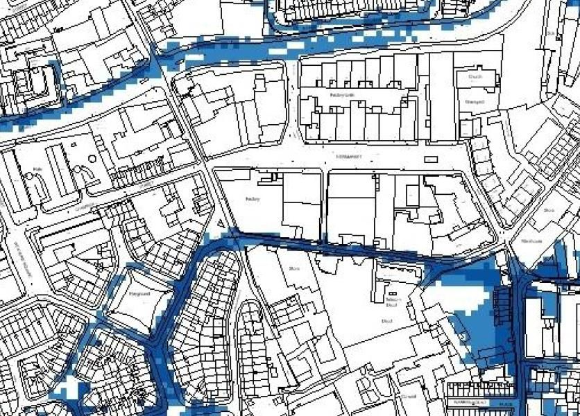
Document No.:              19.308-IR-02                                                              4

          •   The main resident access to the BTR units is provided via a foyer (50 sqm) at ground floor
              level fronting onto Ardee Street, incorporating a reception desk and
              management/maintenance office area. Ancillary services for BTR residents at ground
              floor level include a refuse storage area (58.3 sqm) and a bicycle storage area (184.4 sqm)
              accommodating 238 no. resident/visitor bicycle spaces and 2 no. spaces for cargo bikes.
              Additional external access to the bike and bin storage areas is provided via doors onto
              Mill Street.
          •   606.1 sqm of ground floor level commercial/retail space is proposed, with direct frontage
              onto Newmarket Square and at the corner of Newmarket Square and Ardee Street. The
              commercial/retail unit includes a dedicated refuse storage area (27.9 sqm) and a bike
              storage area (7.7 sqm) accommodating 8 no. spaces. Additional external access to the
              bike and bin storage areas is provided via doors onto Newmarket Square.
          •   The ground floor level also incorporates ancillary infrastructure/services for the building
              including an Energy Centre (80.0 sqm, Water Storage Plant (58.0 sqm) and 2 no. ESB
              substation/switch rooms. The ESB substation/switch rooms are accessed directly from
              Newmarket Square.

      Proposals are also provided for road, footpath, vehicular parking and public realm upgrade works
      in the immediate vicinity of the site. These proposals facilitate the provision of enhanced
      pedestrian facilities along Newmarket Square, Ardee Street and Mill Street, and at the 2 no. road
      junctions immediately to the north-west (Newmarket Square/Ardee Street/Chamber Street
      junction) and south-west (Mill Street/Ardee Street/Oscar Square/Clarance Mangan Road
      junction) of the site respectively. 5 no. additional car parking spaces (including 1 no. dedicated
      car share space) and 1 no. loading bay, together with the relocation of an existing bus stop are
      also provided by the proposed development along Ardee Street.

      The proposed development also includes all associated site and development works and ancillary
      infrastructure including water services, foul and surface drainage and connections, attenuation
      proposals, electrical connections, public lighting and signage.

1.2    SCOPE OF THIS REPORT
       This report outlines the findings of the SSFRA (site specific flood risk assessment) carried out for
       the proposed residential development, and takes cognisance of the following relevant
       guidelines and policies:
       • Department of the Environment Heritage and Local Government (DEHLG) and the Office of
          Public Works (OPW) Guidelines for Planning November 2009 on ‘The Planning System and
          Flood Risk Management Guidelines for Planning Authorities’.
       • The Planning and Development Act 2000.

       The stages involved in the assessment of flood risk are listed in the guidelines as follows:
       • Stage 1: Flood Risk Identification
       • Stage 2: Initial Flood Risk Assessment
       • Stage 3: Detailed Flood Risk Assessment

       The OPW and DEHLG’s publication also outline a Sequential Approach for determining whether
       a particular development is appropriate for a specified location in terms of flood risk. The
       categorisation of the subject site in terms of the OPW and DEHLG’s sequential approach is
       further outlined in Section 3.
Site Specific Flood Risk Assessment - Project: Newmarket / Ardee Street BTR Development Job No. 19.308 - Newmarket SHD
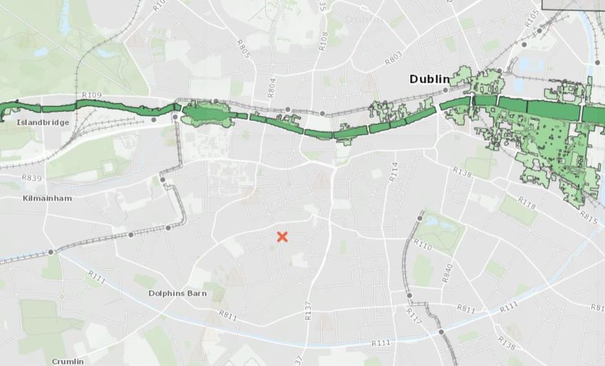
Document No.:              19.308-IR-02                                                         5

2.    STAGE 1: FLOOD RISK IDENTIFICATION

      Stage 1 identifies whether there are any flooding or surface water management issues at the
      subject site location and whether a flood risk assessment is required. This involves review of
      desk study information available as outlined in the following headings.

      Table 2.1 The possible sources of flood water

       Source              Pathway             Receptor    Likelihood   Consequence     Risk

         Tidal Note          Overtop            Property    Very         High             Low
                             Breach                          remote

         Fluvial Note        Overtop            Property    Remote       High             Medium
                             Breach
         Groundwater         Rising             Property    Very         Medium           Low
                             groundwater                    remote
                             levels
         Pluvial             Overflow      /    Property    Possible     Medium           Medium
         Surface water       Blockage

2.1   HISTORICAL FLOODING

      A review of the OPW Historical Flood Maps online was carried out and indicates no flooding
      events in the immediate vicinity of the site.

      On 20th January 1941 flooding associated with the Liffey catchment occurred approximately
      540m northwest of the subject site on Marrowbone Lane.

      Flooding occurred on 10th June 1963 on Clanbrassil Street, approximately 400m southeast of
      the subject site, which was associated with the Liffey catchment.

      Flooding occurred on Wexford Street on 26th July 2013 associated with the null catchment,
      which is approximately 850m east of the subject site.

      The Local Authority notes that a number of defence assets were put in place after these events.

      Recurrent flooding has been recorded at Camac Bow Bridge, however the Local Authority has
      put a number of defence assets in place. This location is 1.3km northwest of the subject site.

      Based on available and recorded information as outlined above, the subject site is considered
      not to have been subject to flooding in recent history.
Site Specific Flood Risk Assessment - Project: Newmarket / Ardee Street BTR Development Job No. 19.308 - Newmarket SHD
Document No.:            19.308-IR-02                                                             6

                           Site Location

      Figure 2.1 Recorded Past Flood Events (Source: OPW – www.floodinfo.ie)

2.2   COASTAL FLOODING
      Coastal flooding occurs when sea levels along the coast of in estuaries exceed neighbouring land
      levels or overcome coastal defences where these exist. A review of the OPW Tidal Flood Extents
      Mapping was carried out and indicates no coastal flooding at the subject site for the following
      flood event probabilities:
      • 10% Tidal AEP (Annual Exceedance Probabilities) or 1 in 10 year return period.
      • 0.5% Tidal AEP or 1 in 200 year return period.
      • 0.1% Tidal AEP or 1 in 1000 year return period.

      Therefore, the risk of tidal flooding is considered low as the subject site lies outside the 0.1%
      AEP.
Site Specific Flood Risk Assessment - Project: Newmarket / Ardee Street BTR Development Job No. 19.308 - Newmarket SHD
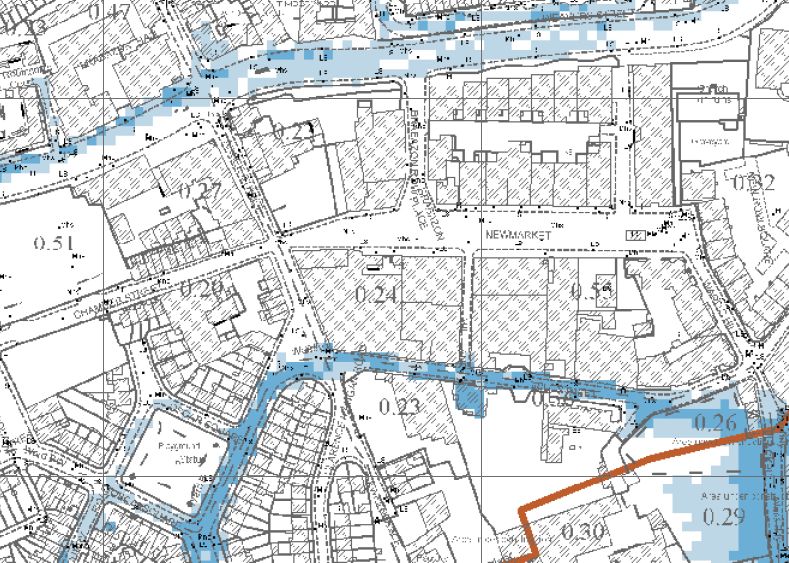
Document No.:            19.308-IR-02                                                             7

                                          Site Location

      Figure 2.2 Tidal Flood Extends (Source: OPW Eastern CFRAM Study)

2.3   FLUVIAL FLOODING
      Fluvial flooding occurs when rivers and streams break their banks and water flows out onto the
      adjacent low-lying areas. A review of the OPW Fluvial Flood Extents Mapping was carried out
      and indicates low and medium probability fluvial flooding at the southern boundary of the
      subject site for the following flood event probabilities:
      • 10% Fluvial AEP (Annual Exceedance Probabilities) or 1 in 10 year return period.
      • 1% Fluvial AEP or 1 in 200 year return period.
      • 0.1% Fluvial AEP or 1 in 1000 year return period.

      The site is not located near any major open watercourses, however a branch of the culverted
      River Poddle flows beneath Mill Street. A review of the OPW Flood Maps database does not
      indicate any history of flood events at or near the subject site. It is worth noting that an open
      part of the River Poddle is located to the south-east of the site, within the Sweeneys Corner
      Student Accommodation development that is currently under construction.

      Flood risk modelling conducted on behalf of the OPW under the Eastern CFRAM (Catchment
      Flood Risk Assessment and Management) Study indicates that the subject site is within an area
      with a fluvial flood event AEP of less than 1%. The risk of fluvial flooding within the site is
      therefore considered low. The OPW Fluvial Flood Extents Maps near the subject site is included
      in Appendix 2 for further information.
Site Specific Flood Risk Assessment - Project: Newmarket / Ardee Street BTR Development Job No. 19.308 - Newmarket SHD
Document No.:             19.308-IR-02                                                            8

                           Proposed
                           Building
                           Location

      Figure 2.3 Fluvial Flood Extents (Source: OPW Eastern CFRAM Study)

2.4   GROUND WATER

      Groundwater flooding occurs when the level of water stored in the ground rises as a result of
      prolonged rainfall, to meet the ground surface and flows out over. A desktop study was carried
      out to review previous site investigations in the surrounding area of the site out to identify
      ground water levels. Ground investigations on an adjacent site (‘The Eight Building’) to the east
      recorded groundwater at 7.70m BGL. The locations of this site investigations in relation to the
      proposed site are shown in Figure 2.4 below. The risk of flooding due to ground water ingress
      to the proposed development is considered low.

                                                                           Adjacent Site
                                                                           ‘The Eight Building’

                     Proposed
                     Building

      Figure 2.4 Site Investigation Info Available From Adjacent Site
Site Specific Flood Risk Assessment - Project: Newmarket / Ardee Street BTR Development Job No. 19.308 - Newmarket SHD
Document No.:             19.308-IR-02                                                               9

      A review of the groundwater vulnerability data from the Geological Survey Ireland (GSI) website
      was also carried out and the model indicates low risk of groundwater contamination. The map
      identifies how susceptible areas are to groundwater contamination.

                                                                           Site
                                                                           Location

      Figure 2.5 Groundwater Vulnerability (Source: GSI Data Viewer Map)

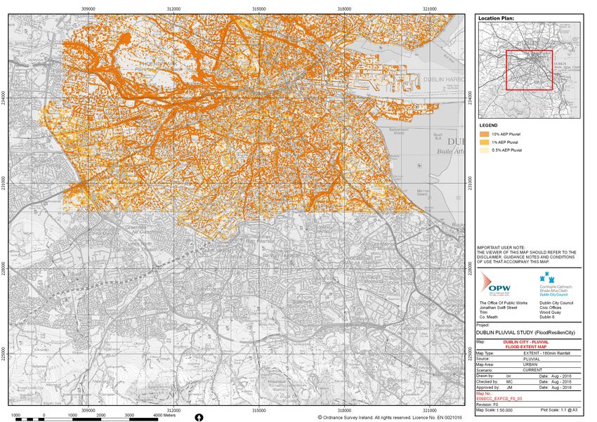
2.5   PLUVIAL FLOODING
      Pluvial flooding occurs when the amount of rainfall exceeds the capacity of urban surface water
      drainage systems or the ground to absorb it. A review of the available literature including the
      DCC FloodResilienCity (FRC) project was carried out and indicates some pluvial flooding
      surrounding the site. Note, these maps are ‘predictive’ flood maps showing areas predicted to
      be inundated during a theoretical or ‘design’ flood event with an estimated probability of
      occurrence, rather than information for actual floods that have occurred in the past, which is
      presented on ‘historical’ flood maps.

      The FRC project considers the subject site to be low risk of pluvial flooding as it is not located in
      low laying areas. The FRC project identifies the main surface of flooding to be surface water run-
      off conveyed by road networks into low lying areas.

      A new surface water system is proposed to collect rainwater from all impervious areas of the
      proposed building along with intensive and extensive green roof areas to reduce the
      developments impact on existing surface water drainage systems. All stormwater will be
      discharged to a Pluvial Cube Attenuation Tank and Soil Infiltration system. The risk of pluvial
      flooding is considered low, due to existing and proposed measures in place.
Document No.:            19.308-IR-02                                                           10

                                                     Site Location

      Figure 2.6 Pluvial Flood Extents (Source: OPW Eastern CFRAM Study)

2.6   CLIMATE CHANGE

      All new developments are required to take climate change into consideration when assessing
      the flood risk of a site. When designing for extreme rainfall events an allowance of 20%
      additional flow should be taken. The system is designed for storms up to and including the 1 in
      100 year storm and 20% extra for climate change. Hence the development can be considered
      to be climate change resilient.
Document No.:            19.308-IR-02                                                              11

3.    STAGE 2: INITIAL FLOOD RISK ASSESSMENT

      The purpose of an initial flood risk assessment is to examine flood risk issues highlighted as part
      of Stage 1 Flood Risk Identification.

      Based on available recorded information as outlined in Stage 1, the site is considered to not
      been subject to flooding in recent history.

      The risk of tidal flooding is considered low as the subject site lies outside the 0.1% AEP.

      The risk of fluvial flooding is considered low based on the Eastern CFRAM Study.

      The risk of flooding due to ground water ingress to the proposed building is considered low.

      The risk of pluvial flooding is considered low, due to the site location and proposed measures
      for the building.

3.1   SEQUENTIAL APPROACH

      The sequential approach used in this assessment follows the guidelines from The Planning
      System and Flood Risk Management Guidelines for Planning Authorities, 2009, see Figure 3.1
      for a graphical representation.

      As outlined in the OPW and DEHLG publication, new developments are divided into three
      categories which are as follows:

      • Highly Vulnerable Development (i.e. power stations, residential)
      • Less Vulnerable Development (i.e. retail, leisure)
      • Water-compatible Development (i.e. car parking, recreational space)

      The proposed residential development comes under the heading of Highly Vulnerable
      Development.
Document No.:              19.308-IR-02                                                                12

    Figure 3.1 Sequential Approach (Source: Guidelines for Planning Authorities, 2009)

    Table 3.1 Matrix of vulnerability versus flood zone (Source: Guidelines for Planning Authorities, 2009)
                                Flood Zone A              Flood Zone B              Flood Zone C

       Highly vulnerable
                                Justification Test        Justification Test        Appropriate
       development

       Less vulnerable
                                Justification Test        Appropriate               Appropriate
       development

       Water compatible
                                Appropriate               Appropriate               Appropriate
       development

    Geographical areas are similarly divided into three categories, based on their risk of river and
    tidal flooding. The three categories are as follows:

    • Flood Zone A – where the probability of flooding from rivers and the sea is highest (greater
      than 1% or 1 in 100 for river flooding or 0.5% or 1 in 200 for coastal flooding).
    • Flood Zone B – where the probability of flooding from rivers and the sea is moderate
      (between 0.1% or 1 in 1000 and 1% or 1 in 100 for river flooding and between 0.1% or 1 in
      1000 and 0.5% or 1 in 200 for coastal flooding).
    • Flood Zone C – where the probability of flooding from rivers and the sea is low (less than
      0.1% or 1 in 1000 for both river and coastal flooding i.e. all areas which are not within zone
      A or B).

    Based on the flood risk identification in Stage 1, the proposed building falls in Flood Zone C,
    Therefore, a ‘Justification Test’ and / or Stage 3 Detailed Flood Risk Assessment is not required.
    The sequential approach shown recommends mitigation measures for residual risks. In addition,
Document No.:           19.308-IR-02                                                              13

    extract from DCC Development Plan 2016-2022 in Figure 3.2 shows the proposed development
    in Flood Zone C in agreement with this SSFRA.

          Building
          Location

    Figure 3.2 Strategic Flood Risk Assessment (Source: Dublin City Development Plan 2016-2022)
Document No.:            19.308-IR-02                                                                14

4.   RESIDUAL FLOOD RISK MANAGEMENT

     As highlighted in Section 2, during extreme rainfall events and where the proposed drainage
     system is blocked, there is a chance that localised ponding will occur. Ensuring that internal
     finished floor levels are set above the highest external surface levels in the vicinity will allow for
     any runoff or ponding to be retained on access road and bicycle parking surfaces. This measure
     given the unlikely event, is considered appropriate for the nature of the development.

5.   CONCLUSION
     This report outlines the findings of the SSFRA carried out for the mixed use, primarily
     residential development at Newmarket Square, Ardee Street and Mill Street, Dublin 8.
     This SSFRA was carried out in accordance with the DEHLG guidelines for Planning 2009 and
     The Planning and Development Act 2000.

     Based on available and recorded information, the site has not been subject to flooding in recent
     history.

     The risk of tidal flooding is considered very low as the subject site lies outside the 0.1% AEP.

     The risk of fluvial flooding in the area is considered low as the proposed site lies outside the 1%
     AEP.

     The risk of flooding due to ground water ingress to the proposed development is considered
     low.

     The risk of pluvial flooding is considered low, due to the site location and proposed measures
     for the development.

     Based on the flood risk identification in Stage 1, the proposed development falls in Flood Zone
     C. Therefore, the proposed development is deemed ‘Appropriate’ in accordance with the
     guidelines of the OPW’s publication.
Appendix 1
Site Plan Layout
Notes:
                                                                                                                                                                                                                       DO NOT SCALE FROM THIS DRAWING. USE FIGURED DIMENSIONS IN ALL
                                                                                                                                                                                                                              CASES. VERIFY DIMENSIONS ON SITE AND REPORT ANY
                                                                                                                                                                                                                       DISCREPANCIES TO THE ARCHITECTS IMMEDIATELY. THIS DRAWING TO
                                                                                                                                                                                                                        BE READ IN CONJUNCTION WITH THE ARCHITECTS SPECIFICATION. ©
                                                                                                                                                                                                                        THIS DRAWING IS COPYRIGHT AND MAY ONLY BE REPRODUCED WITH
                                                                                                                                                                                                                                         THE ARCHITECTS PERMISSION.

                                                                                                                                                                                                                       Drawing Notes:
                                                                                                                                                                                                           BUS
          BUS                                                                                                                                                                                                                      N

                                                                                                                                                                                                    IN G
                                                                                                                                                                                                 LO AD
                                                                                                                                                                                          IN G
                                                                                                                                                                                       LO AD
                                                                                                                                                                                                                 BUS
                BUS

                                                                                                                                                   Refer to road
                                                                                                                                                   layout in Engineering

                                                                                                BUS
                                                                                                                                                   drawings                                                                  PLANNING LEGEND

                                                                                                                                                                     26959
                                                                                                                                                                                         NEWMARKET SQUARE

                                                                           BUS
                                                                                   17572
                                                                                                                                                                                                                                                 Site Boundary Line

                                           14424
                                                                                                                                                         LOADING   LOADING   LOADING

                                                                                                                                                                                                                                                 Applicant Ownership
                STOP

                                                                                                                                                                                                                                                 Boundary
                           STOP

                                                                                                                                    4373
                                                                                                                      3549

                          00
                       124
                                                                                       ROOF
                                                                                       PLANT                                                                       FFL +34.296 m
                                                                                                                             FFL +37.296 m
                                                                                                       FFL +43.339 m                                                                                                   P01   10.11.21    LH    ISSUED FOR PLANNING
                                  23                                                                                                UP
                               100                                                         UP
                                                                                           UP                                       UP
                                                                                                                                                                                                                       Rev       Date    DRN               Description
                           BUS

                                                                                                                                                         Refer to
                                                                                                                                                         Landscaping
                                           543
                                  AR

                                  BUS                                                                                         FFL +19.000 m              drawings
                                              70

                                                                                                   FFL +40.339 m

                                                                                                                                           19569
                                    DE

                                                                                                                                                       39079
                                                   LO
                                                    AD
                                                        IN G
                                       E

                                                                                                                                                                                                                             Reddy Architecture + Urbanism
                                                               LO

                                                                                                                                                                                                                             Dartry Mills,
                                                                AD
                                        S TR
                                                                    IN G

                                                                                                                                                                                                                             Dartry Road
                                                                                                                     3143                                                                                                    Dublin 6, D06 Y0E3.
                                                                                                                                                                                                                             T: +353 (0)1 4987000
                                            EE

                                                                                                                                                                                                                             W: www.reddyarchitecture.com
                                                                                                                                                                                                                             E: info@reddyarchitecture.com
                                                   T

                                                                                                       FFLUP
                                                                                                           +36.957 m
                                                                                                         UP                                                                                                            Client Details:
                                                                                                                                                                                                                       NREK1 Limited
                                                                                 7
                                                                              953
                                                                                                         17157
                                                                                                                                                                                                                       Project Details:
                                                                                                                                                                                                                       Ardee Street
                                                                                                              8154
                                                   STOP

                                                                                                                     10833

                                                                                                                                                                                                                       18 Newmarket, Dublin 8
                                                                                                       STOP

                                                                                                                                               MILL STR
                                                                               7

                                                                                                                                                       EET
                                                                             59
                                                                           23

                                                                                                                                                                                                                       Drawing Title:
                                                                                                                                                                                                                       Proposed Site Layout Plan

                                                                                                                                                                                                                       Job No                 Date               Scale@A3
                                                                                                                                                                                                                       P19-149D               11/23/21           1:500
                                                                                                STOP                                                                                                                   Status                                    Drawn By:
                                                                                                                                                                                                                       Planning                                  LH

                                                                                                                                                                                                                       Purpose                                   Checked By:
                                                                                                                                                                                                                       Planning                                  EOB
                                                                                                                                                                                                                       Drawing Number                                    Revision
Roof
1 : 500                                                                                                                                                                                                                P19-149D_RAU- 3.1_004                               P01
Appendix 2
OPW Flood Maps
Subject Site at Ardee St
/ Newmarket D8
314200                                  314400                             314600                              314800         315000                 315200                  315400                  315600                  315800

         Node Label        Water Level (OD) Flow (m³/s)     Water Level (OD) Flow (m³/s)   Water Level (OD) Flow (m³/s)
                           10% AEP          10% AEP         1% AEP           1% AEP        0.1% AEP         0.1% AEP
234400

                                                                                                                                                                                                                                               234400
         SO15331313           8.4            2.26                8.43         2.62              8.46         3.21
         SO15333813           5.52           4.19                5.94         4.67              6.63         5.72
         SO15345201           2.53           4.4                 2.59         4.98              2.69         6.27

                                                                                                                                                                                                                                                                                     Poddle

                                                                                                                                                                                            SO15345201
234200

                                                                                                                                                                                                                                               234200
                                                                                                                                                                                                            (
                                                                                                                                                                                                            !                                                   IMPORTANT USER NOTE:
                                                                                                                                                                                                                                                         THE VIEWER OF THIS MAP SHOULD REFER
                                                                                                                                                                                                                                                          TO THE DISCLAIMER, GUIDANCE NOTES
                                                                                                                                                                                                                                                              AND CONDITIONS OF USE THAT
                                                                                                                                                                                                                                                                 ACCOMPANY THIS MAP.
                                                                                                                                                                                                                                                         Legend
                                                                                                                                                                                                                                                                   10% Fluvial AEP Event
                                                                                                                                                                                                                                                                   1% Fluvial AEP Event
                                                                                                                                                                                                                                                                    0.1% Fluvial AEP Event
                                                                                                                                                                                                                                                                   Modelled River Centreline
234000

                                                                                                                                                                                                                                               234000
                                                                                                                                                                                                                                                                   AFA Extents

                                                                                                                                                                                                                                                           (
                                                                                                                                                                                                                                                           !       Node Point

                                                                                                                                                                                                                                                        Node ID Node Label

                                                                                                                                                                 SO15333813

                                                                                                                                                                                  (
                                                                                                                                                                                  !
233800

                                                                                                                                                                                                                                               233800
                                                                                                                                                                                                                                                                            FINAL

                                                                                                                                                                                                                                                         REV:        NOTE:                              DATE :
233600

                                                                                                                                                                                                                                               233600
                                          Subject Site at
                                          Ardee St /
                                          Newmarket D8
233400

                                                                                                                                                                                                                                               233400
                                                                                                                                                      (
                                                                                                                                                      !                                                                                                 The Office of Public Works
                                                                                                                                                                                                                                                        Jonathan Swift Street
                                                                                                                                                                                                                                                                                        Elmwood House T +44(0) 28 90 667914
                                                                                                                                                                                                                                                                                        74 Boucher Road F +44(0) 28 90 668286
                                                                                                                                                                                                                                                        Trim                            Belfast            W www.rpsgroup.com
                                                                                                                                                                                                                                                        Co Meath                        BT12 6RZ       E ireland@rpsgroup.com

                                                                                                                                                               SO15331313                                                                               Map:
                                                                                                                                                                                                                                                        Poddle River Fluvial Flood Extents
                                                                                                                                                                                                                                                        Map Type: EXTENT
                                                                                                                                                                                                                                                        Source:   FLUVIAL
                                                                                                                                                                                                                                                        Map Area: HPW
                                                                                                                                                                                                                                                        Scenario:        CURRENT
233200

                                                                                                                                                                                                                                               233200
                                                                                                                                                                                                                                                        Drawn By :           F.M.C.      Date : 11 August 2016
                                                                                                                                                                                                                                                        Checked By : A.S.                Date : 11 August 2016
                                                                                                                                                                                                                                                        Approved By : S.P.               Date : 11 August 2016
                                                                                                                                                                                                                                                        Drawing No. :

                                                                                                            (
                                                                                                            !                                                                                                                                           E09POD_EXFCD_F0_06
           314200                                  314400                             314600                              314800         315000                 315200                  315400                  315600                  315800
           0          50   100               200                300                  400               500
                                                                                                                                                                                                                                                        Map Series : Page 6 of 6

                                                                                                         Metres                      [
                                                                                                                            SO14337104        © Ordnance Survey Ireland. All rights reserved. Licence number EN 0021016/OfficeofPublicWorks.
                                                                                                                                                                                                                                                        Drawing Scale : 1:5,000 @A3
Document No.:   19.308-IR-02   1
You can also read