Resilience and adaptation to volcanoes in Late Middle Ages in Lipari island (Aeolian, Italy) - Annals of Geophysics
←
→
Page content transcription
If your browser does not render page correctly, please read the page content below
ANNALS OF GEOPHYSICS, 64, 5, VO549, 2021; doi:10.4401/ag-8648
        OPEN ACCESS

Resilience and adaptation to volcanoes in Late
Middle Ages in Lipari island (Aeolian, Italy)
Maria Clara Martinelli*,1, Marco Manni2, Mauro Coltelli2

(1)
      Parco Archeologico delle Isole Eolie - Museo Luigi Bernabò Brea, Lipari
(2)
      Istituto Nazionale di Geofisica e Vulcanologia - Osservatorio Etneo, Catania

Article history: received March 4, 2021; accepted August 17, 2021

               Abstract
               Volcanic activity resumed during early Middle Ages times at Lipari following at least 6000 years of
               quiescence. This phenomenon occurred in a social context that had continuously developed from
               prehistoric times to the Roman age and was burdened by a demographic crisis that involved the
               archipelago between the 6th and 11th century AD. The rare archaeological records relating to the 6th - 11th
               centuries suggest abrupt changes in the population of the islands. The medieval sources are rich in
               religious and fantastic references to volcanic events linked to Lipari and Vulcano, testifying the uneasy
               condition for the human communities. This work concerns the resilience and adaptation of the
               communities to volcanic activity during the Late Middle Ages in Lipari. Starting from 1083 the Aeolian
               archipelago was involved in a repopulation program, implemented in 1095 by the Constitutum and
               organized by the Benedictine Monastery with the annexed S. Bartolomeo Cathedral on the castle. From
               the 13th century the volcanic phenomena, strictly limited to the northern sector of the island, did not
               interfere as previously with the anthropic activities. The Monastery will be enlarged in the Norman
               phase during the first half of the 12th century with the construction of the cloister. New historical
               documents relating to the 1264, report news of fires and land movements on Lipari. Recent age
               determinations obtained for the obsidian flow of Rocche Rosse at 1220 ± 30 AD (archaeomagnetic
               dating) and for an obsidian block of the Lami pyroclastic cone at 1243 ± 190 (fission-track dating) allow
               to define the age of the last phase of activity of the Monte Pilato-Lami-Rocche Rosse complex, and to
               associate it the events reported on 1264’s historical documents. This work makes in comparison
               volcanological, archaeological and historical dates and described an updated summary of one of the
               lesser known phases of the history of the archipelago. The main consequence of the medieval volcanic
               activity at Lipari caused a clear division of the territory with the population confined in the southeast
               quadrant, protected to the north by Serra and Monte Rosa which represented a natural orographic barrier.

               Key words: Aeolian Island; Middle Ages; Lipari; Volcano activity.

1. Introduction
   The population of the Aeolian islands (Figure 1) in the medieval period, from the 6th century to the 13th century,
has many gaps in research that make difficult the historical reconstruction. This contribution will try to offer some
new information to the historical and cultural context of the last eruptions of Lipari that involved the island between

                                                                                                                             1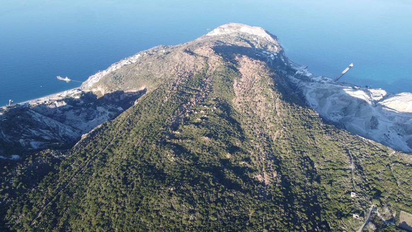
Maria Clara Martinelli et al.

the 8th and the 13th centuries. This contribution, although not exhaustive, take in consideration historical,
archaeological and volcanological data with the aim to focus the changes of the territory and human communities
in relation to the volcanic activity.

Figure 1. Localization of Aeolian islands in the southern Tyrrhenian sea (Italy).

2. Archaeological reports
    Lipari was inhabited since the middle of the sixth millennium BC, with some periods of demographic crisis
[Manni et al., 2019], as attested by the large archaeological reports [Martinelli, 2020; Bernabò Brea and Cavalier,
1998]. After the IV-VI century AD the archaeological data decrease considerably, indicating a period of abandonment
until the eleventh century. The archaeological evidences relating to the 4th - 6th centuries, although insufficient,
suggest that some changes occurred both in the population size and in the topography of the main settlements
[Zagari, 2015; 2017]. After the sixth century, data are drastically reduced and even today it is not possible to obtain
information about Lipari community that probably follows to inhabit the inner flat plains [Giustolisi, 2001]. The
archaeological stratigraphy of the Contrada Diana necropolis, previously used in the Greek and Roman age, provides
important information. The sector with burials dated to the 4th - 6th century AD was investigated in trench XXXVI
[Bernabò Brea and Cavalier, 1994] where, as had already been observed in other excavation trenches of the same
necropolis (Figure 2), the archaeological layers were covered by a pumice layer, usually very thin but in some areas
reaching a thickness of 20 cm. This layer occurs under 0.80 or 1.00 m from the modern agriculture level. It was used
in the stratigraphic sequence of the history of Lipari as a post quem term because it is connected to the volcanic
activity localized in the north-east sector of the island. A radiocarbon dating 1241 ± 31BP, corresponding to 776 AD
[Keller, 1970; 2002], was correlated with the pumice layer. In the stratigraphy of the Contrada Diana site the pumice
layer is covered by one meter of agricultural soil without material (pottery, stone etc.) referred to the human
occurrence after the sixth century. Furthermore, this layer appears intact suggesting the absence of any agricultural
or other activities that would have erased or dispersed the pumice [Bernabò Brea, 1988: 128].
    After the devastation caused by the Arabs in 838, the rebuilding of the fortified citadel of Lipari began in the
Norman age between 1082 and 1085 due to the arrival of a group of Benedictine monks led by Abbot Ambrogio
[Iacolino, 1998]. The church with the cloister is the most important architectural element [Bernabò Brea, 1998;
Bernabò Brea and Cavalier, 2003; Tabanelli, 2017] that was built on a blackish layer of burning covering the floor

2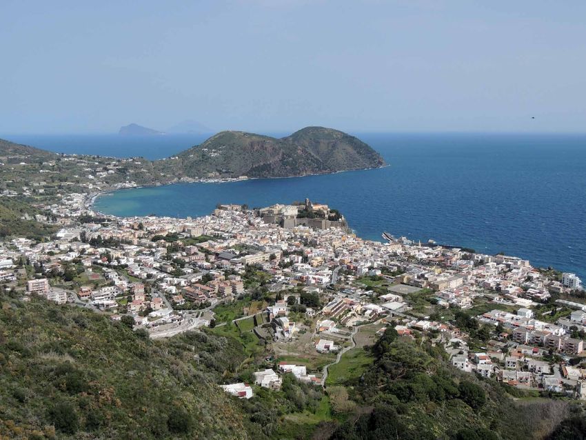
Resilience to volcanoes in Lipari island

of an older structure. This layer was attributed to the Arab destruction on the basis of the finding of a leaden seal
of the Byzantine age with the name of Constantino, who was strategist of Sicily in 813 [Bernabò Brea, 1998: 27].
    The Vulcano island does not preserve traces of settlements until the nineteenth century. Its constant and violent
volcanic activity has changed the morphology of the island several times where, however, occasional visits for
mining, hunting and forest exploitation likely occurred since the Bronze Age.

Figure 2. Excavation in Contrada Diana (Lipari): 1) Trench XXXVI – 1974; 2) Particular of pumice layer; 3) Trench XXIX
         – 1966 (after Bernabò Brea and Cavalier [1994]).

                                                                                                                    3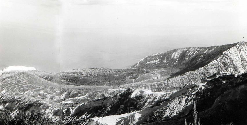
Maria Clara Martinelli et al.

3. Volcanological data
   During Middle Ages the activity of the Lipari-Vulcano complex is characterized by several eruptive events. In
Lipari (Figure 3), a main eruption occurs in the early Middle Ages in the Monte Pilato after a quiescence of about
6,000 years, forming a pumice cone of 150 m of elevation and about 1 km wide northernmost of the pre-historical
volcanic center of Gabellotto. The upper part is composed by pyroclastic deposits of pumice, that have been
deposited in a relatively short span of time due to the frequent fallouts produced by magmatic- and hydromagmatic-
type explosions [Dellino and La Volpe, 1995]. Two radiometric age determinations have been provided for this
eruption. The first standard radiocarbon dating [Keller, 1970] estimated its occurrence at 1220 ± 50 BP, which is a
calendar age of 780–785 AD, while the second performed through “high precision AMS radiocarbon” [Keller, 2002]
recorded the same at 1241 ± 31 BP and 776 AD calibrated age. Samples for both dating were collected from the
paleosol below the recent pumice, deposited on the south-east flank of Monte Chirica near Lami village.

Figure 3. Geological sketch map of the NE sector of Lipari (modified after Forni et al. [2013]). IGM Map sector with
          archaeological sites in Lipari around Monte Rosa (redrawing by Bernabò Brea and Cavalier in 1990).

4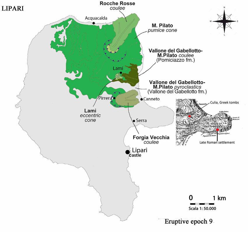
Resilience to volcanoes in Lipari island

    Successively, Lipari enters in a volcanic quiescence until the early XIII century, when the Forgia Vecchia eruption
occurs [Malaguti et al., 2020]. Although the dynamic of this eruptions is not yet clarified on the whole, the obsidian
lava was generated in the area of Pirrera–Forgia Vecchia and flowed eastward down to the coast forming a two lobes
flow behind Canneto village; this eruption was previously dated at 1,6 ± 38 BP [Bigazzi and Bonadonna, 1973; Forni
et al., 2013]. It should be noted that the absence of pumice layers on its surface seems to confirm as this event was
subsequent to the eruptive phases of Monte Pilato occurred in VIII century [Cortese et al., 1986]. Forni et al. (2013)
questioned the age attribution of Bigazzi and Bonadonna [1973], owing to the absence of the Monte Pilato
pumiceous products above the Forgia Vecchia lava flow. They proposed that the Forgia Vecchia and Monte Pilato
activities are time-equivalent.
    Furthermore, the eruptive activity resumed in the inner area of Monte Pilato center, forming the Rocche Rosse
crater, partially destroyed by the successive obsidian lava overflow. This latter has extensively covered the north-
east slope of the cone with the more than 60 m thick and 2 km long Rocche Rosse flow, reaching the sea in
correspondence of the actual Punta Castagna and Acquacalda village (Figure 4).
    Archaeomagnetic datings estimated this flow around 1230 +/- 40 AD [Tanguy et al., 2003; Forni et al., 2013],
1240 ± 30 [Arrighi et al., 2006] or around 1300 [Malaguti et al., 2020]. In the same time is the Lami cone eruption
occurred, near the small village of Lami on the south-east flank of Monte Pilato. Obsidian samples collected on the
cone have been dated through the fission tracks method at 1243 ± 190 AD [Bigazzi et al., 2003].

Figure 4. View from the Rocche Rosse crater area and Rocche Rosse obsidian flow down to Punta Castagna (photo M.
         Manni 2021).

4. Historical sources
   In the 7th - 8th century the reports of religious travellers [Garbini, 2010: 31-32] mainly concern Vulcano, with the
only exception of that given by San Gregorio in 787, where a description of both submarine volcanic activities
observed in the channel between Lipari and Vulcano, and an eruption on the island of Lipari is provided [Bernabò
Brea, 1988]. The voyage of San Willibald in 729 was determinant for the description of an eruption of pumice emitted
by Vulcano [Iacolino, 1996]. Arab sources of the 10th - 12th century are telling again about the pumice of Vulcano,
while a description of 1184-1185 concerns Vulcano and Vulcanello that “send fire forever” [see Pagliara, 1995 and
references therein].

                                                                                                                     5
Maria Clara Martinelli et al.
Historical data becomes more precise in the thirteenth century and in particular in the years 1264-1265 when
Lipari is mentioned in a chronicle of the Pisan Annals and in a report of the Universitas of Patti. The first describes
Lipari burned by the hellfire that arose from the same island in October 1264; the latter mentioned instead the loss
of documents due to destructions on Lipari. The words “everssione terre Lipparis” are used to indicate the devastation
of lands. This destructive event is still mentioned in 1265 to justify the loss of a document that granted a privilege
to the church of Patti.
5. Chronicle of the 1264 by Pisan Annals
A short chronicle given by an anonymous Pisan author belonging to the Ghibelline faction is contained in the
appendix to Annales Pisanorum (Pisan Annals) which covers the period from 1101 to 1268 [Lupo Gentile, 1930-1936].
A.D. MCCLXV, de mense Octub. insula Lipari combusta fuit igne infernali, sive qui exivit de inferis dicte insule.
In the year of the God 1265 (= 1264 of the current calendar), in the month of October, the island of Lipari was
burned by a hellfire, emerging from the same island.
6. Examination of the minutes of Universitas of Patti dated 1 September 1265
In a minute registered on 31 August 1265 at the Universitas of Patti there are two letters sent by King Manfredi
to Nicolao Tavily, the “stratigoto” (magistrate of the city) of Messina, respectively on 26 February and 13 August 1265
[Girgensohn and Kamp, 1965]. Both concerned a privilege claimed by the bishop of Lipari, Bonconte di Pendenza,
in favour of the bishopric of Lipari-Patti. It is a privilege granted by King William of Sicily who exempted the Church
of Patti from paying contributions in favour of the royal fleet. The original certificates of William II and Federico
II with regular signet, could not be provided because it was lost during the destruction of the lands of Lipari
(everssione terre Lipparis) [Iacolino, 2001].
a) Letter of Manfredi to the city magistrate dated: Orte, 26 February 1265.
“…quia dicta privilegia regis Guillelmi et domini patri nostri de predicta exempcione eclesie predicte indulta in
everssione terre Lipparis cum rebus aliis pluribus, quas habebat idem electus ibidem, ammissa fuerant et ea tibi,
dum contendis ab eo ius lignaminum et marinarie exigere, ad defensionem suam et dicte eclesie sue pretendere et
monstrare non potest, licet ipsa autenticata habebat …”.
..as the mentioned privileges of King William and our Lord father granted to the same church and as the
privileges were lost in the ruin of the lands of Lipari with a certain number of other things, which the same
elect kept in the same place, while he requires the timber and navy privileges, for both his and the Church
defence, cannot show the same authenticated as he had ...
b) Letter of Manfredi to the city magistrate dated: Amatrice, 13 August 1265.
“...exempcionem eclesie sue Pactensis de iure marinarie et lignaminum ostendere et edocere non posset per privilegia
divorum progenitorum nostrum, que in casu Lipparis se asserit ammisisse…”
The exemption of the Patti Church from navy and timber law, granted by privilege of our ancestors, cannot
be shown as it is claimed to have been lost in the events of Lipari [Iacolino, 2001: 295].
7. Discussion
The Middle Ages is characterized by an increasing of the volcanic activity of the Lipari-Vulcano system, which
involved the eruptive centres of Lipari (Monte Pilato, Forgia Vecchia and Rocche Rosse) (Figure 5) and Vulcano
(Gran Cratere and Vulcanello). The area of the Castle was rebuilt between 1082 and 1085, including a new church
and a Benedictine monastery related to the new settled community after the Arab invasion in 838.
The promulgation of the Constitutum in 1095 regulated the assignment of the land of the south-west part of Lipari to
private locals through concessions in perpetuum, with the aim of improve the recolonization of this island [Iacolino, 1998].
6Resilience to volcanoes in Lipari island
On the contrary, the land in the north-east sector (near Forgia Vecchia and Monte Pilato) was not assigned as
emphyteusis for many centuries. In fact, according to the description in an act of 1246 conserved in episcopal archive
of Patti [Iacolino, 2007], the subdivision of the farmlands owned by the Church included only the south-west sector
of the island.
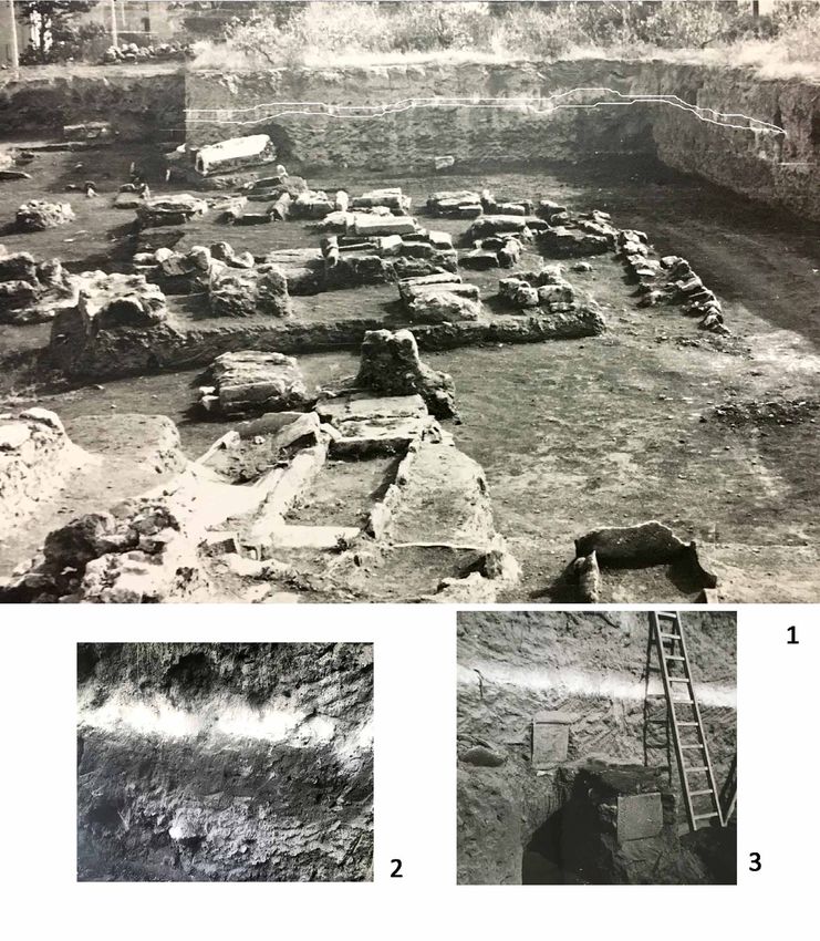
Figure 5. View of the Rocche Rosse crater (photo 1950).
The main reason is certainly related to the new cycle of volcanic activity that occurred since the eighth century
and that reached its maximum peak in the thirteenth century with the eruption Rocche Rosse [Tanguy et al., 2003;
Forni et al., 2013]. This latter culminated with the formation of the homonymous obsidian flow. The Rocche Rosse
flow (dated around 1230-1240) together with the Lami cone, on the south-east flank of Monte Pilato, (around 1243)
represent the last eruptions of Lipari.
Two documents dated at 1264 are the last historical sources where are described these important natural events
that occurred in Lipari and therefore could be referred to the last eruptions of Lipari, namely Rocche Rosse and
Lami. These events offer to the Lipari churchmen an useful piece of evidence to justify the lacking of a
documentation proving their privileges. At the same time, the volcanic activity determined strong constrains that
allow to use only the non-affected sector of the island, while northernmost of Monte Rosa (Figure 6) the hazard due
to the eruptive centres of Forgia Vecchia, Rocche Rosse and Lami represented an obstacle for human and agricultural
expansion.
Only from the end of the sixteenth century, a gradual demographic grow will determine the birth of the villages
of Canneto, Pirrera, Serra, Lami and Acquacalda, all located in the northern sector of the island where, it is presumed,
post-eruption effects like volcanic gas emission from the ground, not fertile volcanic soils, etc., has hampered the
human settlement for a long time. Still in 1593 in the locality of Acquacalda, only two areas were granted in
emphyteusis to private locals by the Church [Iacolino, 1998; 2007]. Finally, the Monte Pilato area was systematically
exploited as a pumice mining industry from 1880 to 2007.
7Maria Clara Martinelli et al.
Figure 6. View of Lipari city and Monte Rosa-Serra (photo M.C. Martinelli).
8. Conclusion
The end of the Roman Empire and the dependence by Byzantium of the Sicily after 535 AD [Zagari, 2017] brought
changes in human settlements. In the Aeolian Islands, these changes may have been influenced by the effect of the
volcanism, especially on the Lipari-Vulcano complex. At the island of Lipari, after a long period of quiescence from
the seventh millennium BC, the volcanic activity shown a significant recrudescence in the Middle Ages.
The lack of archaeological findings (settlements, walls, pottery, etc.) from the 6th to the 11th century AD suggests
a pauperisation of the communities with a consequent demographic decrease [Arena, 1991] and an economic decline
of the archipelago. This situation persisted until the 11th century when the Benedictine monastery was founded on
the castle of Lipari.
The morphology of the north-eastern sector of Lipari, affected by the eruptive phases of Forgia Vecchia, Lami
and Rocche Rosse that occurred in the thirteenth century, was completely upset and these areas remained
uninhabited until a few centuries ago. The geological dating of these eruptive phases are in agreement with two
historical sources: the first (Pisani Annals) could be referred to an eruption that occurred in October 1264, the
second (letters to Manfredi) confirm a destructive event occurred in the second half of the same year (before
February 26, 1265).
Although the last volcanic cycle did not hinder the life of the Lipari community in the urban area, it has deeply
marked the morphology of the north-east sector of the island, with the direct consequence to maintain a condition
of abandonment of the same. Only after the sixteenth century, therefore when the volcanic activity (including post-
eruption effects) has been definitively ceased, there are records of human exploitation and expansion in this area
[Iacolino, 2007]. On the other hand, all the eventual remains of ancient settlements in this area should be completely
erased by the successive strong volcanic events. This possibility is suggested by the only archaeological finding
8Resilience to volcanoes in Lipari island
from the Culia area (Figure 3) that lies northernmost the natural barrier of Monte Rosa-Serra and very close to the
southern boundary of Forgia Vecchia coulee, where a nucleus of tombs from the Greek age (4th century BC) attests
the occurrence of a settlement [Martinelli personal communication].
Acknowledgment. Our heartfelt thanks goes to: Francesca De Francesco and Sebastiano Ciavirella (Library University of
Messina) to help in the research of the historical sources. Pietro Lo Cascio (Nesos association, Lipari) for the discussion
on the Aeolian territory and for the reading of the text. Emanuela Guidoboni (EEDIS) for information on Pisan Annals.
References
Arena, G.A.M. (1991). Note sull’economia delle Isole Eolie dal Neolitico alla prima metà del XVI secolo, Annali
dell’Istituto Tecnico Commerciale Antonio Maria Jaci di Messina, 2 serie, II, Messina, 113-148.
Arrighi, S., J.C. Tanguy and M. Rosi (2006). Eruptions of the last 2200 years at Vulcano and Vulcanello (Aeolian
Islands, Italy) dated by high-accuracy archeomagnetism, Phys. Earth Planet. Int., 159, 225–233.
Bernabò Brea, L. (1988). Le Isole Eolie dal Tardo Antico ai Normanni, Mario Lapucci edizioni del Girasole, Ravenna.
Bernabò Brea, L. (1998). Il chiostro normanno di Lipari. La sua scoperta, il suo restauro, in Spigo U., A. Raffa A. and
M. Saija (Editors), Dal “Constitutum” alle “controversie liparitane”, Quaderni del Museo Archeologico
Regionale Eoliano, Regione Siciliana Assessorato dei Beni Culturali, Palermo, 11-28.
Bernabò Brea, L. and M. Cavalier (1994). Lipari, contrada Diana. Scavo XXXVI in proprietà Zagami (1975-1984),
Meligunis Lipara VII, Regione Siciliana Assessorato dei Beni Culturali, Palermo.
Bernabò Brea, L. and M. Cavalier (1998). Topografia di Lipari in età Greca e Romana, Meligunis Lipara IX, Regione
Siciliana Assessorato dei Beni Culturali, Palermo.
Bernabò Brea, L. and M. Cavalier (2003). Il monastero normanno di Lipari e il suo chiostro, Ricerche e scavi 1954-
1996, Quaderni di Archeologia Università di Messina, 4, 5-51
Bigazzi, G. and F. Bonadonna (1973). Fission Track Dating of the Obsidian of Lipari Island (Italy), Nature, 242, 322-323.
Bigazzi, G., M. Coltelli and P. Norelli (2003). Nuove età delle ossidiane di Lipari determinate con il metodo delle
tracce di fissione, in GeoItalia, 4th Forum FIST, Bellaria, 16–18 September, Abstract Volume, 444–446.
Cortese, M., G. Frazzetta and L. La Volpe (1986). Volcanic history of Lipari (Aeolian islands, Italy) during the last 10
000 years, J. Volcanol. Geother. Res., 27, 117–133.
Dellino, P., and L. La Volpe (1995). Fragmentation versus transportation mechanisms in the pyroclastic sequence of
Monte Pilato-Rocche Rosse (Lipari, Italy), J. Volcanol. Geotherm. Res., 64, 211-231.
Forni, F., F. Lucchi, A. Peccerillo, C.A. Tranne, P.L. Rossi and M.L. Frezzotti (2013). Stratigraphy and geological
evolution of the Lipari volcanic complex (central Aeolian archipelago), Geological Society, London, Memoirs,
37, Ch. 10, 213-279.
Garbini, P. (2010). Il visibilio funesto: i vulcani del medioevo latino, I Quaderni del M.AE.S. Journal of Mediæ Ætatis
Sodalicium, XII-XIII (2009-2010), 23-45.
Girgensohn, D. and N. Kamp (1965). Urkunden und Inquisitionen des 12. Und 13. Jahrhunderts aus Patti. Quellen und
forschungen aus italienischen archiven und bibliotheken. Herausgeben vom Deutschen Historischen Institut
in Rom, Band XLV. Max Niemeyer Verlag Tuingen, Biblioteca Facoltà di Lettere e Filosofia di Messina, 159-186.
Giustolisi, V. (2001). Alla ricerca di Lipari Bizantina, Giustolisi V. (Editor), Regione Siciliana, Assessorato dei Beni
Culturali e Ambientali e P.I., Palermo.
Iacolino, G. (1996). Le Isole Eolie nel risveglio delle memorie sopite. Il primo millennio cristiano, Aldo Natoli Editore,
Lipari.
Iacolino, G. (1998). La società eoliana nell’età della Rinascenza, in Spigo U., A. Raffa. and M. Sajia (Editors), Dal
“Constitutum” alle “controversie liparitane”, Quaderni del Museo Archeologico Regionale Eoliano, Regione
Siciliana Assessorato dei Beni Culturali, Palermo, 63-75.
Iacolino, G. (2001). Le Isole Eolie nel risveglio delle memorie sopite. Dalla rifondazione della Communitas Eoliana
alla battaglia di Lipari del 1339, Aldo Natoli Editore, Lipari.
Iacolino, G. (2007). Le Isole Eolie nel risveglio delle memorie sopite. Dalla battaglia di Lipari del 1339 alla vigilia della
“Ruina” del 1544, Archivio Vescovile di Lipari, Aldo Natoli Editore, Lipari.
9Maria Clara Martinelli et al.
Keller, J. (1970). Datierung der Obsidiane und Bimstuffe von Lipari. Neues Jahrbuch fur Geologie und Palaontologie,
Monatshefte, 1, Stuttgard, 90-101.
Keller, J. (2002). Lipari’s fiery past: dating the medieval pumice eruption of Monte Pelato, in International Conference
UNESCO, Regione Siciliana, Lipari September 29th– October 2nd, oral presentation.
Lupo Gentile, M. (1930-1936). Annales Pisani di Bernardo Maragone, in L.A. Muratori (Editor), (1904) Rerum
italicarum scriptores. Raccolta degli storici italiani dal cinquecento al millecinquecento, VI, II, nuova ed.,
Zanichelli, Bologna. https://archive.org/details/p2archiviomurato06fior/page/116/mode/2up
Malaguti, A.B., E. Billotta, M. Pistolesi, F. Lucchi, C.A. Tranne, P. G. Albert, A. Di Roberto, F. Speranza and M. Rosi
(2020). Volcanological and chronological characterization of the recent (last 2000 years) rhyolitic eruptions
of Lipari (Aeolian Islands, Southern Italy), in Conferenza A. Rittmann, Catania, 12-14 Febbraio 2020, Abstract,
Miscellania INGV 52, 58-60 https://www.conferenzarittmann.it/sessioni/programma.html
Manni, M., M. Coltelli and M.C. Martinelli (2019). Volcanic events that have marked the anthropic history of the
Aeolian Islands, Ann. Geophys., 62, 1, https://doi.org/10.4401/ag-7716
Martinelli, M.C. (2020). Isole vicine. L’arcipelago delle isole Eolie e le comunità umane nella preistoria mediterranea,
Edizioni di Storia e studi sociali, Ragusa.
Pagliara, A. (1995). Fonti per la storia dell’arcipelago eoliano in età greca con un’Appendice sull’epoca romana, in
Bernabò Brea L. and M. Cavalier, Meligunis Lipara VIII, parte seconda, Accademia di Scienze Lettere e Arti di
Palermo, Palermo.
Tabanelli, M. (2017). Il chiostro di San Bartolomeo a Lipari: sperimentazioni progettuali e decorative nella prima
comunità benedettina della Sicilia normanna, in Hortius Artum Medieval, 23/1, 318-327.
Tanguy, J.C., M. Le Goff, C. Principe, S. Arrighi, V. Chillemi, A. Paiotti, S. La Delfa and G. Patanè (2003).
Archeomagnetic dating of Mediterranean volcanics of the last 2100 years: validity and limits, Earth Planet. Sci.
Lett., 211, 121–123.
Zagari, F. (2015) Le isole Eolie in epoca bizantina. Primi dati di una rilettura topografica, in Arthur P. and M.L.
Imperiale (Editors), in VII congresso nazionale di archeologia medievale, vol. 2, All’insegna del Giglio, Firenze,
454-458.
Zagari, F. (2017). Due antiche diocesi dello stretto di Messina: insediamento, manufatti, infrastrutture e produzione
nell’epachia delle Saline e nelle isole Eolie tra Tardoantico e Alto Medioevo, Archeopress, Oxford.
*CORRESPONDING AUTHOR: Maria Clara MARTINELLI,
Parco Archeologico delle Isole Eolie,
Museo Luigi Bernabò Brea, Lipari (ME) Italy;
e-mail: martinellimariaclara@gmail.com
© 2021 the Author(s). All rights reserved.
Open Access. This article is licensed under a Creative Commons Attribution 3.0 International
10You can also read